Maryland ( EE. UU .: / ˈ m ɛr ɪ l ə n d / MERR-il-ənd)[b]es unestadode laregiónAtlántico MedioEstados Unidos.[8][9]Limita conVirginiaal sur,Virginia Occidentalal oeste,Pensilvaniaal norte,Delawarey elocéano Atlánticoal este, y la capital nacional deWashington, DCal suroeste. Con una superficie total de 12.407 millas cuadradas (32.130 km2), Maryland es elnoveno estado más pequeño por superficie terrestre,[10]y su población de 6.177.224 lo ubica como el19.º estado más pobladoy elquinto más densamente poblado. La capital de Maryland esAnnapolis, y la ciudad más poblada esBaltimore.[11]
La costa de Maryland fue explorada por primera vez por los europeos en el siglo XVI. Antes de eso, estaba habitada por varias tribus nativas americanas , principalmente los pueblos algonquinos . [12] Como una de las Trece Colonias originales , Maryland fue fundada por George Calvert , primer barón Baltimore, un católico converso [13] [14] que buscaba proporcionar un refugio religioso para los católicos perseguidos en Inglaterra. [15] En 1632, Carlos I de Inglaterra le otorgó a Lord Baltimore una carta colonial , nombrando la colonia en honor a su esposa, Henrietta Maria . [16] En 1649, la Asamblea General de Maryland aprobó una Ley sobre Religión , que consagró el principio de tolerancia . [17] Los conflictos religiosos fueron comunes en los primeros años de Maryland, y los católicos siguieron siendo una minoría, aunque en mayor número que en cualquier otra colonia inglesa. Los primeros asentamientos y centros de población de Maryland se agruparon alrededor de vías fluviales que desembocan en la bahía de Chesapeake . Su economía se basaba en gran medida en las plantaciones y se centraba principalmente en el cultivo de tabaco . La demanda de mano de obra barata por parte de los colonos de Maryland llevó a la importación de numerosos sirvientes contratados y africanos esclavizados . En 1760, los límites actuales de Maryland tomaron forma tras la resolución de una disputa fronteriza de larga data con Pensilvania. Muchos de sus ciudadanos desempeñaron papeles políticos y militares clave en la Guerra de la Independencia de los Estados Unidos . Aunque era un estado esclavista , Maryland permaneció en la Unión durante la Guerra Civil estadounidense , y su proximidad a Washington DC y Virginia lo convirtió en una ubicación estratégica importante . Después de que terminó la Guerra Civil, Maryland participó en la Revolución Industrial , impulsada por sus puertos marítimos, redes ferroviarias y la inmigración masiva desde Europa.
Desde la década de 1940, la población del estado ha crecido rápidamente, hasta aproximadamente seis millones de residentes, y se encuentra entre los estados más densamente poblados de EE. UU. En 2015 [actualizar], Maryland tenía el ingreso familiar promedio más alto de todos los estados, debido en gran parte a su proximidad a Washington, DC, y una economía altamente diversificada que abarca la manufactura, los servicios minoristas, la administración pública, los bienes raíces, la educación superior, la tecnología de la información, la contratación de defensa, la atención médica y la biotecnología. [18] Maryland es uno de los estados más multiculturales del país; es uno de los seis estados donde los no blancos componen la mayoría de la población , con el quinto porcentaje más alto de afroamericanos y un alto número de residentes nacidos en África , Asia , América Central y el Caribe . El papel central del estado en la historia de los EE. UU. se refleja en que alberga algunos de los números más altos de monumentos históricos per cápita.
La parte occidental del estado contiene tramos de los Montes Apalaches , la parte central está compuesta principalmente por el Piamonte y el lado oriental del estado constituye una parte importante de la Bahía de Chesapeake . Dieciséis de los veintitrés condados de Maryland y la ciudad de Baltimore bordean las aguas de marea del estuario de la Bahía de Chesapeake y sus numerosos afluentes, [19] [11] que combinados suman más de 4000 millas de costa. Aunque es uno de los estados más pequeños de los EE. UU., presenta una variedad de climas y características topográficas que le han valido el apodo de América en miniatura . [20] De manera similar, la geografía, la cultura y la historia de Maryland combinan elementos de las regiones del Atlántico Medio, Noreste y Sur del país.
Lo que ahora es Maryland estaba habitado originalmente por tribus como los piscataway (incluidos los patuxent ), los nanticoke (incluidos los tocwogh , los ozinie y otras subdivisiones), los powhatan , los lenape , los susquehannock , los shawnee , los tutelo , los saponi , los pocomoke y los massawomeck . [21] [ ¿ fuente autoeditada? ] George Calvert, primer barón de Baltimore (1579-1632), solicitó una carta del rey Carlos I para el territorio entre Massachusetts al norte y Virginia al sur inmediato. [22] Después de que Baltimore muriera en abril de 1632, la carta fue otorgada a su hijo, Cecilius Calvert, segundo barón de Baltimore (1605-1675), el 20 de junio de 1632. Oficialmente, la nueva "Colonia de Maryland" recibió el nombre en honor a Henrietta Maria de Francia , esposa de Carlos I. [23] Lord Baltimore propuso inicialmente el nombre "Crescentia", la tierra de crecimiento o incremento, pero "el Rey propuso Terra Mariae [Tierra de Mary], que se concluyó e insertó en el proyecto de ley". [15]
La capital original de Maryland fue St. Mary's City , en la costa norte del río Potomac , y el condado que la rodea, el primero erigido/creado en la provincia, [24] se llamó primero Augusta Carolina, en honor al Rey, y luego se llamó St. Mary's County. [25]
Los primeros colonos de Lord Baltimore llegaron a la nueva colonia en marzo de 1634, con su hermano menor, el Honorable Leonard Calvert (1606-1647), como primer gobernador provincial de Maryland . Hicieron su primer asentamiento permanente en St. Mary's City, en lo que ahora es el condado de St. Mary's . Compraron el sitio al jefe supremo de la región, que estaba ansioso por establecer el comercio. St. Mary's se convirtió en la primera capital de Maryland y permaneció así durante 60 años hasta 1695. Pronto llegaron más colonos. Sus cultivos de tabaco tuvieron éxito y rápidamente hicieron que la nueva colonia fuera rentable. Sin embargo, dada la incidencia de la malaria , la fiebre amarilla y la fiebre tifoidea , la esperanza de vida en Maryland era unos 10 años menor que en Nueva Inglaterra . [26]
Maryland fue fundada para proporcionar un refugio a la minoría católica romana de Inglaterra . [27] Aunque Maryland era la colonia más católica de las colonias continentales inglesas, la religión todavía era minoritaria y representaba menos del 10% de la población total. [28]
En 1642, varios puritanos abandonaron Virginia para ir a Maryland y fundaron la ciudad de Providence, ahora llamada Annapolis , en la costa occidental de la parte superior de la bahía de Chesapeake . [29] Una disputa con comerciantes de Virginia sobre la isla Kent en Chesapeake condujo a un conflicto armado. En 1644, William Claiborne , un puritano, se apoderó de la isla Kent mientras que su socio, el puritano pro-parlamento Richard Ingle , se hizo cargo de St. Mary's. [30] Ambos utilizaron la religión como herramienta para ganar apoyo popular. Los dos años de 1644 a 1646 en los que Claiborne y sus asociados puritanos dominaron se conocieron como "La época del saqueo". Capturaron a sacerdotes jesuitas, los encarcelaron y luego los enviaron de regreso a Inglaterra.
En 1646, Leonard Calvert regresó con tropas, recuperó la ciudad de St. Mary y restableció el orden. La Cámara de Delegados aprobó la "Ley sobre religión" en 1649, que otorgaba libertad religiosa a todos los cristianos trinitarios . [26]
En 1650, los puritanos se rebelaron contra el gobierno propietario. "Los protestantes expulsaron a los católicos de la legislatura ... y volvieron los conflictos religiosos". [26] Los puritanos establecieron un nuevo gobierno que prohibía tanto el catolicismo romano como el anglicanismo . El gobierno revolucionario puritano persiguió a los católicos de Maryland durante su reinado, conocido como la "época del saqueo". Las turbas quemaron todas las iglesias católicas originales del sur de Maryland. El gobierno puritano duró hasta 1658, cuando la familia Calvert y Lord Baltimore recuperaron el control propietario y promulgaron nuevamente la Ley de Tolerancia.
Después de la Gloriosa Revolución de Inglaterra en 1688, Maryland proscribió el catolicismo. En 1704, la Asamblea General de Maryland prohibió a los católicos operar escuelas, limitó la propiedad corporativa de la propiedad para impedir que las órdenes religiosas se expandieran o se mantuvieran a sí mismas y fomentó la conversión de niños católicos. [28] La celebración de los sacramentos católicos también fue restringida oficialmente. Esta situación duró hasta después de la Guerra de la Independencia de los Estados Unidos (1775-1783). Los ricos plantadores católicos construyeron capillas en sus tierras para practicar su religión en relativo secreto.
Hasta el siglo XVIII, sacerdotes individuales y líderes laicos reclamaron las granjas de Maryland pertenecientes a los jesuitas como propiedad personal y las legaron para evadir las restricciones legales a la propiedad de las organizaciones religiosas. [28]

La carta real concedió a Maryland la tierra al norte del río Potomac hasta el paralelo 40. Surgió un problema cuando Carlos II concedió una carta para Pensilvania . La concesión definía la frontera sur de Pensilvania como idéntica a la frontera norte de Maryland, el paralelo 40. Pero la concesión indicaba que Carlos II y William Penn asumieron que el paralelo 40 pasaría cerca de New Castle, Delaware , cuando se encuentra al norte de Filadelfia , el sitio que Penn ya había seleccionado para la capital de su colonia. Las negociaciones se produjeron después de que se descubriera el problema en 1681.
Un compromiso propuesto por Carlos II en 1682 se vio socavado por la concesión adicional que recibió Penn de lo que hoy es Delaware. [32] Penn argumentó con éxito que la carta de Maryland sólo otorgaba a Lord Baltimore derechos sobre tierras no colonizadas, y que el asentamiento holandés en Delaware era anterior a su carta. La disputa permaneció sin resolver durante casi un siglo, continuada por los descendientes de William Penn y Lord Baltimore: la familia Calvert , que controlaba Maryland, y la familia Penn , que controlaba Pensilvania. [32]
La disputa fronteriza con Pensilvania dio lugar a la Guerra de Cresap en la década de 1730. Las hostilidades estallaron en 1730 y se intensificaron durante la primera mitad de la década, culminando con el despliegue de fuerzas militares por parte de Maryland en 1736 y de Pensilvania en 1737. La fase armada del conflicto terminó en mayo de 1738 con la intervención del rey Jorge II, que obligó a negociar un alto el fuego. En 1732 se había establecido un acuerdo provisional. [32]
Las negociaciones continuaron hasta que se firmó un acuerdo final en 1760. El acuerdo definió la frontera entre Maryland y Pensilvania como la línea de latitud ahora conocida como la línea Mason-Dixon . La frontera de Maryland con Delaware se basó en una línea transpeninsular y el círculo de doce millas alrededor de New Castle. [32]
La mayoría de los colonos ingleses llegaron a Maryland como sirvientes contratados y tuvieron que cumplir una condena de varios años como trabajadores para pagar su pasaje. [33] En los primeros años, la línea entre los sirvientes contratados y los esclavos o trabajadores africanos era fluida, y los trabajadores blancos y negros vivían y trabajaban juntos y formaban sindicatos. Los niños mestizos nacidos de madres blancas eran considerados libres según el principio de partus sequitur ventrem , por el cual los niños adoptaban el estatus social de sus madres, un principio de la ley esclavista que se adoptó en todas las colonias, después de Virginia en 1662.
Muchas de las familias negras libres emigraron a Delaware, donde la tierra era más barata. [34] A medida que el flujo de trabajadores contratados a la colonia disminuyó con la mejora de las condiciones económicas en Inglaterra, los plantadores de Maryland importaron miles de esclavos más y las líneas de castas raciales se endurecieron.
Maryland fue una de las trece colonias que se rebelaron contra el dominio británico en la Guerra de Independencia de los Estados Unidos . Cerca del final de la Guerra de Independencia de los Estados Unidos (1775-1783), el 2 de febrero de 1781, Maryland se convirtió en el último y decimotercer estado en aprobar la ratificación de los Artículos de la Confederación y la Unión Perpetua , propuestos por primera vez en 1776 y adoptados por el Segundo Congreso Continental en 1778, que dieron origen a los Estados Unidos como un estado unido, soberano y nacional . También se convirtió en el séptimo estado admitido en la Unión después de ratificar la nueva Constitución federal en 1788. En diciembre de 1790, antes del traslado de la capital nacional desde Filadelfia en 1800, Maryland donó tierras seleccionadas por el primer presidente George Washington al gobierno federal para su creación. La tierra fue proporcionada a lo largo de la costa norte del río Potomac desde los condados de Montgomery y Prince George , así como desde el condado de Fairfax y Alexandria en la costa sur del Potomac en Virginia ; Sin embargo, la tierra donada por la Mancomunidad de Virginia fue posteriormente devuelta a ese estado mediante la retrocesión del Distrito de Columbia en 1846.

Influenciados por una economía cambiante, ideales revolucionarios y la prédica de los ministros, numerosos plantadores de Maryland liberaron a sus esclavos en los 20 años posteriores a la Guerra de la Independencia . En todo el Alto Sur, la población negra libre aumentó de menos del 1% antes de la guerra al 14% en 1810. [35] Los abolicionistas Harriet Tubman y Frederick Douglass nacieron esclavos durante esta época en el condado de Dorchester y el condado de Talbot , respectivamente. [36] [37]
Durante la Guerra de 1812 , el ejército británico intentó capturar Baltimore, que estaba protegida por Fort McHenry . Durante el bombardeo, Francis Scott Key escribió la canción " The Star-Spangled Banner " ; más tarde se adoptó como himno nacional.
La carretera nacional, posteriormente rebautizada como Ruta 40 de los EE. UU ., fue autorizada en 1817 como carretera federal y discurría desde Baltimore hasta San Luis . El ferrocarril Baltimore and Ohio (B&O), el primer ferrocarril autorizado en los Estados Unidos, abrió su primera sección de vía para su funcionamiento regular en 1830 entre Baltimore y Ellicott City , [38] y en 1852 se convirtió en la primera línea ferroviaria en llegar al río Ohio desde la costa este. [39]

El estado permaneció en la Unión durante la Guerra Civil estadounidense , [40] debido en gran parte a la demografía y a la intervención federal. El censo de 1860, realizado poco antes del estallido de la Guerra Civil, mostró que el 49% de los afroamericanos de Maryland eran libres . [35]
El gobernador Thomas Holliday Hicks suspendió la legislatura estatal y, para ayudar a asegurar la elección de un nuevo gobernador y legislatura pro-unión, el presidente Abraham Lincoln hizo arrestar a varios de sus políticos pro-esclavitud, incluido el alcalde de Baltimore, George William Brown ; suspendió varias libertades civiles, incluido el habeas corpus ; y ordenó colocar artillería en Federal Hill con vista a Baltimore.
En abril de 1861, las unidades federales y los regimientos estatales fueron atacados mientras marchaban por Baltimore, lo que desencadenó el motín de Baltimore de 1861 , el primer derramamiento de sangre en la Guerra Civil. [41] De los 115.000 habitantes de Maryland que se unieron al ejército durante la Guerra Civil, alrededor de 85.000, o el 77%, se unieron al ejército de la Unión , mientras que el resto se unió al Ejército Confederado . [ cita requerida ] La batalla más grande y más significativa en el estado fue la Batalla de Antietam el 17 de septiembre de 1862, cerca de Sharpsburg . Aunque fue un empate táctico, la batalla se consideró una victoria estratégica de la Unión y un punto de inflexión de la guerra.
Una nueva constitución estatal en 1864 abolió la esclavitud y Maryland fue reconocido por primera vez como un "Estado Libre" en ese contexto. [42] Tras la aprobación de enmiendas constitucionales que otorgaron derechos de voto a los libertos , en 1867 el estado extendió el sufragio a los varones no blancos.
El Partido Demócrata recuperó rápidamente el poder en el estado de manos de los republicanos . Los demócratas reemplazaron la Constitución de 1864 por la Constitución de 1867. Tras el final de la Reconstrucción en 1877, los demócratas idearon medios para privar de sus derechos a los negros, inicialmente mediante la intimidación física y el fraude electoral, y más tarde mediante enmiendas constitucionales y leyes. Sin embargo, los negros y los inmigrantes resistieron los esfuerzos del Partido Demócrata para privarlos de sus derechos en el estado. Los negros de Maryland formaban parte de una coalición republicana birracial elegida para el gobierno estatal entre 1896 y 1904 y comprendían el 20% del electorado. [43]
En comparación con otros estados, los negros estaban mejor establecidos tanto antes como después de la guerra civil. Casi la mitad de la población negra era libre antes de la guerra, y algunos habían acumulado propiedades. La mitad de la población vivía en ciudades. El nivel de alfabetización era alto entre los negros y, a medida que los demócratas ideaban medios para excluirlos, las campañas por el sufragio ayudaron a llegar a los negros y a enseñarles a resistir. [43] Los blancos impusieron la segregación racial en los establecimientos públicos y las leyes de Jim Crow , que efectivamente duraron hasta la aprobación de la legislación federal sobre derechos civiles a mediados de los años 1960.
Baltimore creció significativamente durante la Revolución Industrial , debido en gran parte a su puerto marítimo y a sus buenas conexiones ferroviarias, que atrajeron mano de obra inmigrante europea. Muchas empresas manufactureras se establecieron en el área de Baltimore después de la Guerra Civil. Los empresarios de Baltimore, incluidos Johns Hopkins , Enoch Pratt , George Peabody y Henry Walters , fundaron importantes instituciones en la ciudad que llevan sus nombres, entre ellas, respectivamente, una universidad , un sistema de bibliotecas , un conservatorio de música y danza y un museo de arte .
Cumberland fue la segunda ciudad más grande de Maryland en el siglo XIX. La proximidad a ella de los recursos naturales y los ferrocarriles favorecieron su crecimiento hasta convertirse en un importante centro manufacturero. [44]

La era progresista de finales del siglo XIX y principios del XX trajo consigo reformas políticas. En una serie de leyes aprobadas entre 1892 y 1908, los reformistas trabajaron para que los estados emitieran papeletas estándar (en lugar de las que distribuían y marcaban los partidos); obtuvieron cabinas de votación cerradas para evitar que los trabajadores del partido "ayudaran" a los votantes; iniciaron elecciones primarias para evitar que los jefes del partido seleccionaran candidatos; y tenían candidatos en listas sin símbolos del partido, lo que desalentaba la participación de los analfabetos . Estas medidas funcionaron en contra de los blancos y negros con poca educación. Los negros resistieron tales esfuerzos, y los grupos sufragistas llevaron a cabo la educación de los votantes. Los negros derrotaron tres esfuerzos para privarlos del derecho al voto, haciendo alianzas con inmigrantes para resistir varias campañas demócratas. [43] Los proyectos de ley de privación del derecho al voto en 1905, 1907 y 1911 fueron rechazados, en gran parte debido a la oposición negra. Los negros representaban el 20% del electorado y los inmigrantes el 15%, y la legislatura tuvo dificultades para idear requisitos contra los negros que no perjudicaran también a los inmigrantes. [43]
La era progresista también trajo consigo reformas en las condiciones laborales de la fuerza laboral de Maryland. En 1902, el estado reguló las condiciones en las minas , prohibió el trabajo infantil a los menores de 12 años, impuso la asistencia escolar obligatoria y promulgó la primera ley de compensación laboral del país . La ley de compensación laboral fue revocada en los tribunales, pero se volvió a redactar y finalmente se promulgó en 1910.
El gran incendio de Baltimore de 1904 duró más de 30 horas, destruyó 1.526 edificios y abarcó 70 manzanas de la ciudad. Más de 1.231 bomberos trabajaron para controlar el incendio.
Con la entrada del país en la Primera Guerra Mundial en 1917, se establecieron nuevas bases militares como Camp Meade , Aberdeen Proving Ground y Edgewood Arsenal . Las instalaciones existentes, incluido Fort McHenry , se ampliaron considerablemente.
Después de que el congresista de Georgia William D. Upshaw criticara abiertamente a Maryland en 1923 por no aprobar leyes de prohibición , el editor del Baltimore Sun, Hamilton Owens, acuñó el apodo de "Estado Libre" para Maryland en ese contexto, que fue popularizado por HL Mencken en una serie de editoriales de periódicos. [42] [45]
Las comunidades urbanas y rurales de Maryland vivieron experiencias diferentes durante la Gran Depresión . El " Ejército de Bonificaciones " marchó por el estado en 1932 en su camino hacia Washington, DC. Maryland instituyó su primer impuesto sobre la renta en 1937 para generar ingresos para las escuelas y la asistencia social. [46]
El servicio de barcos de vapor de pasajeros y mercancías, que alguna vez fue importante en toda la bahía de Chesapeake y sus numerosos ríos tributarios, finalizó en 1962. [47]
Baltimore fue un importante centro de producción bélica durante la Segunda Guerra Mundial . Las mayores operaciones fueron Fairfield Yard de Bethlehem Steel , que construía los barcos Liberty , y Glenn Martin , un fabricante de aviones.
Maryland experimentó un crecimiento demográfico después de la Segunda Guerra Mundial. A principios de la década de 1960, a medida que el crecimiento suburbano se afianzó alrededor de Washington, DC y Baltimore, el estado comenzó a adoptar una cultura más del Atlántico medio en oposición a la cultura tradicionalmente sureña y de Tidewater que anteriormente dominaba la mayor parte del estado. Las áreas agrícolas dieron paso a comunidades residenciales, algunas de ellas cuidadosamente planificadas, como Columbia , St. Charles y Montgomery Village . Al mismo tiempo, se construyó el sistema de autopistas interestatales en todo el estado, sobre todo la I-95 , la I-695 y la Capital Beltway , lo que alteró los patrones de viaje. En 1952, las mitades este y oeste de Maryland se conectaron por primera vez mediante el puente de la bahía de Chesapeake , que reemplazó a un servicio de ferry cercano . [48]
Las regiones de Maryland experimentaron cambios económicos después de la Segunda Guerra Mundial. La industria pesada disminuyó en Baltimore. En los cuatro condados más occidentales de Maryland, los empleos industriales, ferroviarios y mineros de carbón disminuyeron. En la costa este sur , las granjas familiares fueron compradas por grandes empresas y las granjas avícolas a gran escala y el cultivo de hortalizas se hicieron comunes. En el sur de Maryland, el cultivo de tabaco casi desapareció debido al desarrollo suburbano y a un programa estatal de compra de tabaco en la década de 1990.
En un esfuerzo por revertir la despoblación causada por la pérdida de industrias de la clase trabajadora, Baltimore inició proyectos de renovación urbana en la década de 1960 con el Charles Center y el Baltimore World Trade Center . Algunos de ellos dieron como resultado la desintegración de barrios residenciales intactos, lo que produjo volatilidad social, y algunas áreas residenciales más antiguas alrededor del puerto han sido renovadas y se han vuelto populares entre las nuevas poblaciones.
Maryland tiene una superficie de 12.406,68 millas cuadradas (32.133,2 km 2 ) y es comparable en superficie total con Bélgica [11.787 millas cuadradas (30.530 km 2 )]. [49] Es el 42º estado más grande y el 9º más pequeño y es el más cercano en tamaño al estado de Hawái [10.930,98 millas cuadradas (28.311,1 km 2 )], el siguiente estado más pequeño. El siguiente estado más grande es el vecino de Maryland, Virginia Occidental , que es casi el doble del tamaño de Maryland [24.229,76 millas cuadradas (62.754,8 km 2 )].


Maryland posee una variedad de topografía dentro de sus fronteras, lo que contribuye a su apodo de América en miniatura . [50] Varía desde dunas arenosas salpicadas de pastos marinos en el este, hasta pantanos bajos repletos de vida silvestre y grandes cipreses calvos cerca de la bahía de Chesapeake, hasta colinas suavemente onduladas de bosques de robles en la región de Piedmont y pinares en las montañas de Maryland al oeste.
Maryland limita al norte con Pensilvania , al norte y al este con Delaware , al este con el océano Atlántico y al sur y al oeste, al otro lado del río Potomac , con Virginia Occidental y Virginia . La parte media de su frontera con Virginia está interrumpida por Washington, DC , que se encuentra en tierras que originalmente formaban parte de los condados de Montgomery y Prince George y que incluyen Georgetown, Maryland , que fue cedido al gobierno federal de los Estados Unidos en 1790 para formar la Bahía de Chesapeake de Washington, DC casi divide el estado en dos, y los condados al este de la bahía se conocen colectivamente como la Costa Este .
La mayoría de las vías fluviales del estado forman parte de la cuenca hidrográfica de la bahía de Chesapeake, con la excepción de una pequeña porción del extremo occidental del condado de Garrett (drenado por el río Youghiogheny como parte de la cuenca hidrográfica del río Mississippi ), la mitad oriental del condado de Worcester (que desemboca en las bahías costeras atlánticas de Maryland) y una pequeña porción del extremo noreste del estado (que desemboca en la cuenca hidrográfica del río Delaware ). La bahía de Chesapeake es tan importante en la geografía y la vida económica de Maryland que ha habido agitación periódica para cambiar el apodo oficial del estado a "Bay State", un apodo que Massachusetts ha utilizado durante décadas.
El punto más alto de Maryland, con una elevación de 3360 pies (1020 m), es Hoye Crest en Backbone Mountain , en la esquina suroeste del condado de Garrett , cerca de la frontera con Virginia Occidental y cerca de las cabeceras del brazo norte del río Potomac. Cerca de la pequeña ciudad de Hancock , en el oeste de Maryland, aproximadamente a dos tercios del camino a través del estado, menos de 2 millas (3,2 km) separan sus fronteras, [51] la línea Mason-Dixon al norte y el río Potomac que se arquea hacia el norte al sur.
Algunas partes de Maryland están incluidas en varias regiones geográficas oficiales y no oficiales. Por ejemplo, la península de Delmarva está compuesta por los condados de la costa este de Maryland, todo el estado de Delaware y los dos condados que conforman la costa este de Virginia , mientras que los condados más occidentales de Maryland se consideran parte de los Apalaches . Gran parte del corredor Baltimore-Washington se encuentra justo al sur del Piamonte en la llanura costera, [52] aunque se extiende a lo largo de la frontera entre las dos regiones.
Los terremotos en Maryland son poco frecuentes y de pequeña magnitud debido a la distancia del estado a las zonas sísmicas. [53] [54] El terremoto de 5,8 M de Virginia en 2011 se sintió moderadamente en todo Maryland. Los edificios del estado no están bien diseñados para los terremotos y pueden sufrir daños con facilidad. [55] Además de esto, un terremoto de 4,8 M de Tewksbury en el centro de Nueva Jersey se sintió levemente en todo Maryland. [56]
Maryland no tiene lagos naturales, principalmente debido a la falta de historia glacial en el área. [57] Todos los lagos del estado en la actualidad fueron construidos, principalmente a través de represas. [58] Los geólogos creen que Buckel's Bog fue un remanente de un antiguo lago natural. [59]
Maryland tiene formaciones de esquisto que contienen gas natural, donde la fracturación hidráulica es teóricamente posible. [60]

Como es típico en los estados de la Costa Este , la vegetación de Maryland es abundante y saludable. Un volumen adecuado de precipitaciones anuales ayuda a sustentar muchos tipos de plantas, incluidas las praderas marinas y diversos juncos en el extremo más pequeño del espectro, hasta el gigantesco Wye Oak , un enorme ejemplo de roble blanco , el árbol del estado, que puede crecer más de 70 pies (21 m) de altura.
Los bosques costeros del Atlántico medio , típicos de la llanura costera del Atlántico sudoriental , crecen alrededor de la bahía de Chesapeake y en la península de Delmarva . Hacia el oeste, una mezcla de bosques costeros del noreste y bosques mixtos del sureste cubren la parte central del estado. Los montes Apalaches del oeste de Maryland albergan los bosques Apalaches-Blue Ridge . Estos dan paso a los bosques mesofíticos mixtos de los Apalaches cerca de la frontera con Virginia Occidental. [62]
En el estado se cultivan muchas especies extranjeras, algunas como plantas ornamentales y otras como especies novedosas. Entre ellas se incluyen el crespón , el ciprés italiano , la magnolia del sur , el roble vivo en las partes más cálidas del estado, [63] e incluso palmeras resistentes en las partes más cálidas del centro y el este del estado. [64] Las zonas de rusticidad de las plantas del USDA en el estado varían desde las zonas 5 y 6 en el extremo occidental del estado hasta la zona 7 en la parte central y la zona 8 alrededor de la parte sur de la costa, el área de la bahía y partes del área metropolitana de Baltimore . [65] Las especies de plantas invasoras, como el kudzu , el árbol del cielo , la rosa multiflora y el pasto japonés , sofocan el crecimiento de la vida vegetal endémica. [66] La flor estatal de Maryland, la susan de ojos negros , crece en abundancia en grupos de flores silvestres en todo el estado.
El estado alberga una cantidad considerable de venados de cola blanca , especialmente en el oeste boscoso y montañoso del estado, y la superpoblación puede convertirse en un problema. Se pueden encontrar mamíferos que van desde las montañas del oeste hasta las áreas centrales e incluyen osos negros , [67] linces , [68] zorros, coyotes , [69] mapaches y nutrias. [67]
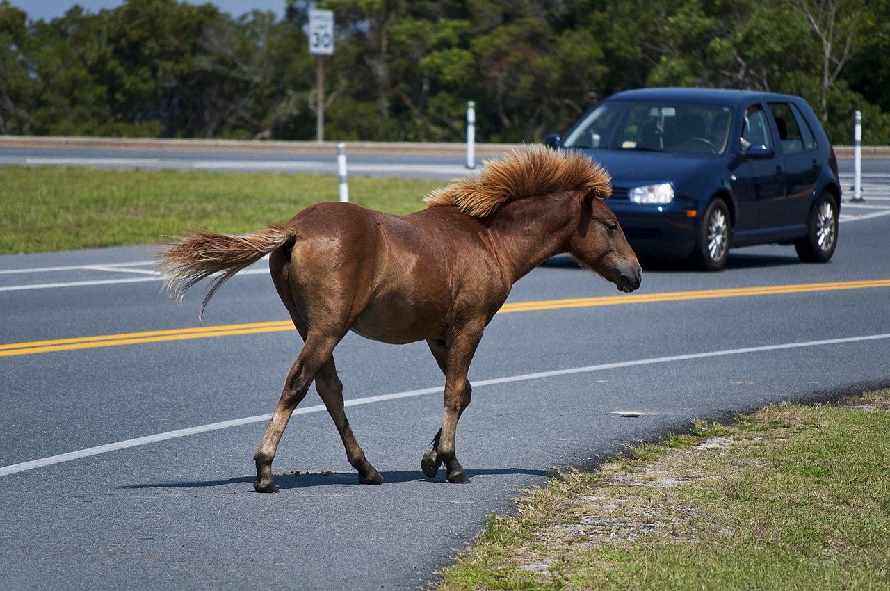
Hay una población de caballos salvajes (asilvestrados) raros en la isla Assateague . [70] Se cree que descienden de caballos que escaparon de naufragios de galeones españoles. [70] Cada año, durante la última semana de julio, son capturados y nadan a través de una bahía poco profunda para su venta en Chincoteague, Virginia , una técnica de conservación que garantiza que la pequeña isla no sea invadida por los caballos. [70] Los ponis y su venta se popularizaron gracias al libro infantil Misty of Chincoteague .
El perro de raza pura Chesapeake Bay Retriever fue criado específicamente para deportes acuáticos, caza y búsqueda y rescate en el área de Chesapeake. [71] En 1878, el Chesapeake Bay Retriever fue la primera raza de retriever individual reconocida por el American Kennel Club . [71] y luego fue adoptado por la Universidad de Maryland, Condado de Baltimore como su mascota.
La población de reptiles y anfibios de Maryland incluye la tortuga de espalda de diamante , que fue adoptada como mascota de la Universidad de Maryland, College Park , así como la amenazada tortuga de caja del este . [72] El estado es parte del territorio del oropéndola de Baltimore , que es el ave oficial del estado y mascota del equipo de la MLB, los Orioles de Baltimore . [73] Además del oropéndola, se han reportado otras 435 especies de aves en Maryland. [74]
El insecto del estado es la mariposa damero de Baltimore , aunque no es tan común en Maryland como lo es en el extremo sur de su área de distribución. [75]
Maryland se unió a los estados vecinos a fines del siglo XX para mejorar la salud de la bahía de Chesapeake . La vida acuática y la industria de mariscos de la bahía se han visto amenazadas por el desarrollo y por los fertilizantes y los desechos del ganado que ingresan a la bahía. [76] [77]
En 2007, Forbes.com clasificó a Maryland como el quinto estado "más verde" del país, detrás de tres de los estados del Pacífico y Vermont. Maryland ocupa el puesto 40 en consumo total de energía a nivel nacional, y gestionó menos desechos tóxicos per cápita que todos los estados excepto seis en 2005. [78] En abril de 2007, Maryland se unió a la Iniciativa Regional de Gases de Efecto Invernadero (RGGI), una iniciativa regional, formada por todos los estados del noreste, Washington, DC y tres provincias canadienses, para reducir las emisiones de gases de efecto invernadero. [79] En marzo de 2017, Maryland se convirtió en el primer estado con reservas probadas de gas en prohibir el fracking al aprobar una ley en su contra. Vermont tiene una ley de ese tipo, pero no el gas de esquisto, y Nueva York tiene una prohibición de ese tipo, aunque se hizo por orden ejecutiva. [60]
En 2023, AES Corporation anunció su intención de retirar la planta de carbón Warrior Run, de 23 años de antigüedad, en junio de 2024. Era la última planta de energía a carbón del estado que aún no tenía planes de cerrar. [80]


Maryland tiene una amplia variedad de climas, debido a las variaciones locales en elevación, proximidad al agua y protección contra el clima más frío debido a los vientos descendentes . La mitad oriental de Maryland, que incluye Ocean City , Salisbury , Annapolis y los suburbios sur y este de Washington, DC y Baltimore , se encuentra en la llanura costera atlántica , con topografía plana y suelo arenoso o fangoso. Esta región tiene un clima subtropical húmedo ( Köppen Cfa ), con veranos cálidos y húmedos e inviernos frescos a fríos; cae dentro de la zona de rusticidad 8a del USDA. [65]
La región de Piedmont , que incluye el norte y el oeste de Baltimore, Westminster , Gaithersburg , Frederick y Hagerstown , tiene nevadas estacionales promedio que generalmente superan las 20 pulgadas (51 cm) y, como parte de las zonas de rusticidad 7b y 7a del USDA, [65] las temperaturas inferiores a 10 °F (−12 °C) son menos raras. Desde el valle de Cumberland hacia el oeste, el clima comienza a transformarse en un clima continental húmedo ( Dfa de Köppen ).
En el oeste de Maryland, las elevaciones más altas de los condados de Allegany y Garrett , incluidas las ciudades de Cumberland , Frostburg y Oakland , muestran más características de la zona continental húmeda, debido en parte a la elevación. Se encuentran dentro de las zonas de rusticidad del USDA 6b y inferiores. [65]
Las precipitaciones en el estado son características de la costa este . La precipitación anual varía de 35 a 45 pulgadas (890 a 1140 mm) con más en las elevaciones más altas. Casi todas las partes de Maryland reciben 3,5 a 4,5 pulgadas (89 a 114 mm) por mes de lluvia. La nevada anual promedio varía de 9 pulgadas (23 cm) en las áreas costeras a más de 100 pulgadas (250 cm) en las montañas occidentales del estado. [81]
Debido a su ubicación cerca de la costa atlántica , Maryland es algo vulnerable a los ciclones tropicales , aunque la península de Delmarva y las orillas exteriores de Carolina del Norte proporcionan una gran protección, de modo que los impactos de huracanes importantes (categoría 3 o superior) ocurren con poca frecuencia. Más a menudo, Maryland recibe los restos de un sistema tropical que ya ha tocado tierra y ha liberado la mayor parte de su energía. Maryland tiene un promedio de alrededor de 30 a 40 días de tormentas eléctricas al año y un promedio de alrededor de seis tornados al año. [82]

La mayor parte de la población de Maryland vive en la región central del estado, en el área metropolitana de Baltimore y el área metropolitana de Washington , ambas parte del área metropolitana de Baltimore-Washington . La mayoría de la población de Maryland se concentra en las ciudades y suburbios que rodean Washington, DC , y en Baltimore y sus alrededores , la ciudad más poblada de Maryland. Históricamente, estas y muchas otras ciudades de Maryland se desarrollaron a lo largo de la Fall Line , la línea a lo largo de la cual los ríos, arroyos y riachuelos se ven interrumpidos por rápidos y cascadas. La capital de Maryland, Annapolis , es una excepción a este patrón, ya que se encuentra a lo largo de las orillas del río Severn , cerca de donde desemboca en la bahía de Chesapeake .
La costa este es menos poblada y más rural, al igual que los condados del oeste de Maryland. Los dos condados más occidentales de Maryland, Allegany y Garrett , son montañosos y escasamente poblados, y se parecen más a Virginia Occidental y Appalachia que al resto del estado. Sin embargo, tanto el este como el oeste de Maryland están salpicados de ciudades de importancia regional, como Ocean City , Princess Anne y Salisbury en la costa este y Cumberland , Frostburg y Hancock en el oeste de Maryland . El sur de Maryland todavía es algo rural, pero la suburbanización de Washington, DC, ha invadido significativamente desde la década de 1960; los centros de población locales importantes incluyen Lexington Park , Prince Frederick , California y Waldorf . [93] [94]

En el censo de los Estados Unidos de 2020 , la Oficina del Censo de los Estados Unidos encontró que la población de Maryland era de 6.185.278 personas, un aumento del 7,1% con respecto al censo de los Estados Unidos de 2010. [ 95] La Oficina del Censo de los Estados Unidos estimó que la población de Maryland era de 6.045.680 el 1 de julio de 2019, un aumento del 4,71% con respecto al censo de los Estados Unidos de 2010 y un aumento de 2.962 con respecto al año anterior. Esto incluye un aumento natural desde el último censo de 269.166 (464.251 nacimientos menos 275.093 muertes) y un aumento debido a la migración neta de 116.713 personas al estado. La inmigración desde fuera de los Estados Unidos resultó en un aumento neto de 129.730 personas, y la migración dentro del país produjo una pérdida neta de 13.017 personas. [96] En 2018, los principales países de origen de los inmigrantes de Maryland fueron El Salvador (11%), India (6%), China (5%), Nigeria (5%) y Filipinas (4%). [97] El centro de población de Maryland está ubicado en la línea del condado entre el condado de Anne Arundel y el condado de Howard , en la comunidad no incorporada de Jessup . [98]
La historia de Maryland como estado fronterizo lo ha llevado a exhibir características tanto de las regiones del norte como del sur de los Estados Unidos. En general, el oeste rural de Maryland entre el Panhandle de Virginia Occidental y Pensilvania tiene una cultura de los Apalaches ; las regiones de la costa sur y este de Maryland encarnan una cultura sureña , [99] mientras que el centro de Maryland densamente poblado, que irradia hacia afuera desde Baltimore y Washington, DC , tiene más en común con la del noreste . [100] La Oficina del Censo de los EE. UU. designa a Maryland como uno de los estados del Atlántico Sur , pero otras agencias federales, los medios de comunicación y algunos residentes lo asocian comúnmente con los estados del Atlántico Medio y el noreste de los Estados Unidos . [101] [102] [103] [104] [105]
Según el Informe Anual de Evaluación de Personas sin Hogar de 2022 del HUD , se estima que había 5.349 personas sin hogar en Maryland. [106] [107]
En 2011, el 58,0 por ciento de la población de Maryland menor de 1 año pertenecía a minorías. [108]
Nota: Los nacimientos en la tabla no suman porque los hispanos se cuentan tanto por su origen étnico como por su raza, lo que arroja un número general más alto.
Desde 2016, no se recopilan datos de nacimientos de origen hispano blanco , sino que se incluyen en un grupo hispano ; las personas de origen hispano pueden ser de cualquier raza.
Composición racial de Maryland excluyendo a los hispanos de las categorías raciales (2019) [121]
NH = No hispano
En 2016, los idiomas más hablados en Maryland aparte del inglés eran el español (9%), el chino (1,2%), las lenguas de África occidental (principalmente yoruba e igbo , 1%), el francés (1%), el coreano (0,7%), las lenguas afroasiáticas (principalmente amárico , 0,6%) y el tagalo (0,6%). Otros idiomas con una gran cantidad de hablantes en Maryland incluyen el vietnamita (0,4%), el árabe (0,4%), el ruso (0,4%), el hindi (0,3%), el urdu (0,3%), el persa (0,3%), el nepalí (0,3%), el criollo haitiano (0,2%) y el telugu (0,2%). [122] [123]

.svg/1280px-Maryland_Counties_by_race_(2020_census).svg.png)
En 1970, la Oficina del Censo de Estados Unidos informó que la población de Maryland era 17,8 por ciento afroamericana y 80,4 por ciento blanca no hispana. [128]
En 2019, los estadounidenses blancos no hispanos eran el 49,8% de la población de Maryland ( los estadounidenses blancos , incluidos los hispanos blancos , eran el 57,3%), lo que convirtió a Maryland en un estado de minoría mayoritaria . [129] El 50,2% de la población de Maryland no es blanca, o es hispana o latina, el porcentaje más alto de cualquier estado de la costa este , y el porcentaje más alto después de los estados de minoría mayoritaria de Hawái , Nuevo México , Texas , California , Nevada y Washington, DC. [130] Para 2031, se proyecta que las minorías se convertirán en la mayoría de los residentes elegibles para votar en Maryland. [131] El multiculturalismo y la diversidad de Maryland se pueden explicar por su población afroamericana históricamente grande y la inmigración traída por la importancia de las áreas de DC y Baltimore, especialmente de América Central, África, el Caribe y Asia.
Los afroamericanos forman una parte considerable de la población del estado, 31,1% a partir de 2020. [127] La mayoría son descendientes de personas transportadas a la zona como esclavos desde África Occidental. Las concentraciones de afroamericanos viven en la ciudad de Baltimore , el condado de Prince George , el condado de Charles , las partes occidentales del condado de Baltimore y la costa este sur. El condado de Charles y el condado de Prince George son los dos condados donde los afroamericanos tienen más éxito monetario en el país, con ingresos familiares promedio mucho más altos que en el resto del país. Como antiguo estado esclavista, Maryland ha tenido una gran población afroamericana durante gran parte de su historia; las poblaciones afroamericanas han aumentado con el tiempo con la Gran Migración a las áreas de DC y Baltimore, y en tiempos más recientes con la Nueva Gran Migración y con el movimiento desde Washington DC hacia los condados de Montgomery, Prince George y Charles, como resultado de la gentrificación y el aumento de los costos de la vivienda en DC, lo que provocó que muchos afroamericanos se fueran. El condado de Prince George, en particular, ha sido un imán para los afroamericanos de DC durante décadas; a menudo se lo conoce como el "distrito 9" de DC.
Maryland tiene, con diferencia, el porcentaje más alto de residentes nacidos en África fuera de cualquier estado; los residentes de ascendencia africana incluyen inmigrantes del siglo XX y posteriores de Nigeria , en particular de las tribus igbo y yoruba ; Etiopía , en particular los amharas con importantes poblaciones oromo y tigray ; Camerún , Ghana , Sierra Leona y Kenia . [132] Maryland también alberga poblaciones de otras naciones africanas y caribeñas . La población inmigrante africana de Maryland es generalmente bien educada y está más concentrada en los suburbios interiores de Baltimore y DC Los nigerianos son el cuarto grupo de inmigrantes más grande de Maryland, y se concentran en gran medida en el área de Baltimore y los suburbios circundantes, así como en el condado de Prince George. Muchos inmigrantes del Cuerno de África , especialmente Etiopía , se han establecido en Maryland, con grandes comunidades en los suburbios de Washington, DC, particularmente en los condados de Montgomery y Prince George. El área metropolitana de Washington tiene la población de etíopes más grande del mundo fuera de Etiopía. [133] La comunidad etíope del Gran DC estuvo históricamente basada en los barrios Adams Morgan y Shaw de Washington, DC, pero a medida que la comunidad ha crecido, muchos etíopes se han establecido en Silver Spring . [134] La población etíope estadounidense en Maryland y el resto del área de DC es en gran parte de habla amárica , pero también hay un número significativo de hablantes de oromo y tigriña . El área metropolitana de Washington también alberga una gran comunidad eritrea .
Las principales ascendencias declaradas por los residentes de Maryland son: alemana (15%), irlandesa (11%), inglesa (8%), estadounidense (7%), italiana (6%) y polaca (3%). [135]
Las poblaciones irlandesas americanas se pueden encontrar en toda el área de Baltimore , [136] y los suburbios del norte y este de Washington, DC, en Maryland, que eran descendientes de aquellos que se mudaron a los suburbios [137] de los vecindarios predominantemente irlandeses de Washington, DC [137] [138] ), así como en el oeste de Maryland, donde los trabajadores inmigrantes irlandeses ayudaron a construir el ferrocarril B&O. [136] Se pueden encontrar poblaciones irlandesas más pequeñas pero mucho más antiguas en el sur de Maryland, con algunas raíces que se remontan a la temprana colonia de Maryland. [139] Esta población, sin embargo, todavía sigue siendo culturalmente muy activa y se celebran festivales anuales. [140]
Un gran porcentaje de la población de la costa este y del sur de Maryland son descendientes de estadounidenses de origen británico. La costa este fue colonizada por protestantes, principalmente metodistas , y los condados del sur fueron colonizados inicialmente por católicos ingleses. El oeste y el norte de Maryland tienen grandes poblaciones germano-estadounidenses .
Los inmigrantes europeos más recientes de finales del siglo XIX y principios del XX se establecieron primero en Baltimore, atraídos por sus trabajos industriales. Estos grupos eran en gran parte de ascendencia judía , italiana , griega , polaca , checa , lituana , rusa y ucraniana . La comunidad griega incluye varios judíos griegos . [141] Estos inmigrantes del sur y el este de Europa se concentraron en gran medida en el sureste de Baltimore e influyeron significativamente en la cultura única de la ciudad; aunque muchos se han mudado a las áreas circundantes del condado de Baltimore debido a la gentrificación, la ciudad conserva la cultura y la influencia de estos inmigrantes, y los eventos culturales que celebran a estas comunidades son comunes en Baltimore. Maryland ha tenido una importante presencia judía estadounidense desde principios del siglo XX, con un gran número de inmigrantes judíos en el área de Baltimore, seguido de la migración judía al área de Washington DC; Maryland tiene el quinto porcentaje más alto de residentes judíos en el país (incluido Washington DC), con 239.000 judíos que representan el cuatro por ciento de la población, y el área estadística combinada de Washington-Baltimore , que tiene el séptimo mayor número de judíos de cualquier área metropolitana combinada en el país, con una población judía estimada en 300.000. [ cita requerida ]
La proporción de inmigrantes europeos nacidos en Europa del Este aumentó significativamente entre 1990 y 2010. Tras la disolución de la Unión Soviética, Yugoslavia y Checoslovaquia, muchos inmigrantes de Europa del Este llegaron a los Estados Unidos, de los cuales el 12 por ciento reside actualmente en Maryland. [142] [143]
Los inmigrantes hispanos de finales del siglo XX se han establecido en Aspen Hill , Hyattsville / Langley Park , Glenmont / Wheaton , Bladensburg , Riverdale Park , Gaithersburg , así como en Highlandtown y Greektown en el este de Baltimore. Maryland tiene el mayor porcentaje de residentes de origen centroamericano de todos los estados. [ cita requerida ] Los salvadoreños son el grupo hispano más grande de Maryland, y Maryland tiene el mayor porcentaje de residentes salvadoreños de todos los estados. [ cita requerida ] El área de DC también tiene el mayor porcentaje de salvadoreños de todas las áreas metropolitanas estadounidenses, que se concentran particularmente en los condados de Prince George y Montgomery, y tiene el segundo número total más alto de salvadoreños después del área de Los Ángeles . Otros grupos hispanos con poblaciones significativas en el estado incluyen mexicanos , guatemaltecos , hondureños , dominicanos , peruanos y puertorriqueños , junto con poblaciones crecientes de brasileños , colombianos , ecuatorianos y bolivianos . La población hispana de Maryland está especialmente concentrada en el condado de Montgomery y el condado de Prince George, con otras poblaciones importantes en el área de Baltimore y el condado de Frederick . Maryland tiene una de las poblaciones hispanas más diversas del país, con poblaciones significativas de varias naciones caribeñas y centroamericanas . [144]
Los caribeños americanos tienen una presencia significativa en Maryland, especialmente los jamaiquinos americanos , que representan el 0,6% de la población y han tenido una presencia e influencia significativas en la política y la cultura de Maryland; el actual gobernador de Maryland, Wes Moore , es hijo de una madre inmigrante jamaiquina. Otras nacionalidades caribeñas americanas con una gran población en Maryland incluyen dominicanos , haitianos , trinitarios y tobagonios y guyaneses . Los caribeños americanos están más concentrados en el condado de Prince George, la ciudad de Baltimore y el condado de Baltimore.
Los estadounidenses de origen asiático se concentran en los condados suburbanos que rodean Washington, DC, y en los suburbios de Baltimore, especialmente el condado de Howard , con comunidades chino-estadounidenses , coreano-estadounidenses y taiwanesas-estadounidenses en Rockville , Gaithersburg y Germantown . Los chinos, en particular, forman el segundo grupo más grande de estadounidenses de origen asiático, y son el grupo más grande en el condado de Montgomery. [ cita requerida ] Maryland también tiene una gran población coreano-estadounidense, especialmente en el condado de Howard, donde hay un Koreatown en Ellicott City . [ 145 ] [ 146 ] Los estadounidenses de origen filipino , el grupo más grande de asiáticos del sudeste, forman comunidades importantes en los condados de Montgomery, Prince George's y Charles; otros grandes grupos de asiáticos del sudeste incluyen a los vietnamitas, que se concentran en el condado de Montgomery, y a los birmanos, que se concentran en los condados de Frederick, Howard y Baltimore. [ cita requerida ] Maryland tiene una población estadounidense de origen asiático del sur muy grande y diversa que ha tenido una presencia importante en el estado desde la década de 1970. Los indios americanos son el grupo asiático más grande en Maryland, constituyendo el 1,7 por ciento de la población, y viven en todo el estado, especialmente en los condados de Montgomery y Howard , con grandes cantidades en los condados de Baltimore , Frederick y Prince George . [ cita requerida ] La población indio-americana es cultural y lingüísticamente diversa, y los idiomas indios más hablados son el hindi , el gujarati , el telugu y el tamil . [ cita requerida ] También hay grandes poblaciones pakistaní-americanas en todas las áreas de DC y Baltimore, especialmente en el condado de Baltimore y el condado de Howard, y una gran comunidad bangladesí-americana en el área de DC. [ cita requerida ] Maryland tiene una de las poblaciones más grandes de nepalí-americanos , incluidos los estadounidenses butaneses de ascendencia nepalí, en los EE. UU., muchos de los cuales son inmigrantes recientes o refugiados que buscaron asilo después de la expulsión de Bután o del terremoto de Nepal de 2015.; se estima que hay entre 20.000 y 25.000 nepalíes en Maryland, concentrados en el área de Baltimore con poblaciones significativas en el área de DC. [ cita requerida ] El primer estadounidense nepalí elegido para una legislatura estatal, Harry Bhandari , fue elegido en Maryland, en representación de parte del condado de Baltimore. [147] [148] Hay tres tribus reconocidas por el estado y, en 2020, 31.845 se identificaron como nativos americanos únicamente y 96.805 lo hicieron en combinación con una o más razas diferentes. [149]
Maryland, que atrae a asiáticos y africanos educados a los trabajos profesionales de la región, tiene la quinta mayor proporción de minorías raciales del país. [150]
En 2006, se contabilizaron 645.744 nacidos en el extranjero, lo que representa principalmente a personas de América Latina y Asia. Alrededor del cuatro por ciento son inmigrantes indocumentados . [151]
Según el análisis del censo de Estados Unidos de 2010 realizado por el Instituto Williams, en Maryland viven 12.538 parejas del mismo sexo, lo que representa 5,8 parejas del mismo sexo por cada 1.000 hogares. [152]

Maryland ha sido históricamente prominente para la tradición católica estadounidense porque la colonia inglesa de Maryland fue pensada por George Calvert como un refugio para los católicos ingleses. Baltimore fue la sede del primer obispo católico en los EE. UU. (1789), y Emmitsburg fue el hogar y lugar de entierro de la primera ciudadana nacida en Estados Unidos en ser canonizada , Santa Isabel Ana Seton . La Universidad de Georgetown , la primera universidad católica, fue fundada en 1789 en lo que entonces era parte de Maryland; se convirtió en parte del Distrito de Columbia cuando se creó en la década de 1790. La Basílica del Santuario Nacional de la Asunción de la Virgen María en Baltimore fue la primera catedral católica romana construida en los Estados Unidos, y el arzobispo de Baltimore es, aunque sin primacía formal, el cuasi- primado de los Estados Unidos , [ cita requerida ] y, a menudo, un cardenal. Entre los inmigrantes de los siglos XIX y XX de Europa del este y del sur había muchos católicos.
A pesar de su relevancia histórica para la Iglesia Católica en Estados Unidos, el porcentaje de católicos en el estado de Maryland está por debajo de la media nacional del 20%. Demográficamente, tanto los protestantes como quienes no se identifican con ninguna religión son más numerosos que los católicos.
Según el Pew Research Center en 2014, el 69 por ciento de la población de Maryland se identifica como cristiana . Casi el 52% de la población adulta son protestantes . [d] Después del protestantismo, el catolicismo es la segunda afiliación religiosa más grande, que comprende el 15% por ciento de la población. [153] [154] Las comunidades amish / menonitas se encuentran en los condados de St. Mary's , Garrett y Cecil . [155] El judaísmo es la religión no cristiana más grande en Maryland, con 241.000 seguidores, o el cuatro por ciento de la población total. [156] Los judíos son numerosos en todo el condado de Montgomery y en Pikesville y Owings Mills al noroeste de Baltimore. Se estima que 81.500 judíos estadounidenses viven en el condado de Montgomery, lo que constituye aproximadamente el 10% de la población total. [157] La sede mundial de la Iglesia Adventista del Séptimo Día y la sede nacional de los musulmanes Ahmadía están ubicadas en Silver Spring , en las afueras de Washington, DC.
Según el Public Religion Research Institute , en 2020 el 61 por ciento de la población de Maryland se identificaba con el cristianismo. [158] El protestantismo y el catolicismo romano siguieron dominando el panorama cristiano, y la comunidad judía se mantuvo en el 3% de la población religiosa total. En el caso de los no afiliados, el estudio del PRRI determinó que su porcentaje aumentó al 28% de la población.
Maryland tiene uno de los porcentajes más altos de personas LGBT en su población de todos los estados; el 5,7% de los habitantes de Maryland se identifican como lesbianas, gays, bisexuales, transgénero o queer, el porcentaje más alto de todos los estados. (Washington, DC ocupa un puesto más alto con una población LGBT del 8,6%). Maryland se clasifica como uno de los mejores estados de la nación en cuanto a los derechos de la comunidad LGBT, con protecciones contra la discriminación promulgadas desde 2001 por sexualidad y 2014 por género, legalización del matrimonio entre personas del mismo sexo en 2013, prohibiciones a la terapia de conversión promulgadas en 2018, abolición de la defensa del pánico gay en 2021 y emisión en 2023 de una orden ejecutiva que protege los derechos de las personas transgénero. En 2020, el condado de Montgomery aprobó por unanimidad una ordenanza que implementa una carta de derechos LGBTIQ+.
La primera persona que se describió a sí misma como drag queen fue William Dorsey Swann , nacido como esclavo en Hancock, Maryland. Swann fue el primer estadounidense del que se tiene constancia que emprendió acciones legales y políticas para defender el derecho de la comunidad LGBTQ a reunirse . [159]
En febrero de 2010, el Procurador General Doug Gansler emitió una opinión en la que se afirmaba que la ley de Maryland debía respetar los matrimonios entre personas del mismo sexo celebrados fuera del estado. En ese momento, la Corte Suprema del estado dictó una sentencia que confirmaba la discriminación en el matrimonio. [152]
El 1 de marzo de 2012, el gobernador de Maryland, Martin O'Malley, firmó la ley que prohibía el matrimonio homosexual, después de que fuera aprobada en la legislatura estatal. Los opositores al matrimonio entre personas del mismo sexo comenzaron a reunir firmas para revocar la ley, que se sometió a referéndum, como pregunta 6, en las elecciones de noviembre de 2012. [152] Una encuesta de enero de 2011 de Gonzales Research & Marketing Strategies mostró que el 51% apoyaba el matrimonio en el estado. [160]
En mayo de 2012, el Tribunal de Apelaciones de Maryland dictaminó que el estado reconocería los matrimonios de parejas del mismo sexo que se casaran fuera del estado, sin importar el resultado de las elecciones de noviembre. [152] Los votantes apoyaron el proyecto de ley, aprobando la Pregunta 6 con el 52% contra el 48% el 6 de noviembre de 2012. Las parejas del mismo sexo comenzaron a casarse en Maryland el 1 de enero de 2013. [152]

La Oficina de Análisis Económico estima que el producto estatal bruto de Maryland en 2016 fue de $382.4 mil millones. [161] Sin embargo, Maryland ha estado utilizando el Indicador de Progreso Genuino , un indicador de bienestar, para guiar el desarrollo del estado, en lugar de confiar solo en indicadores de crecimiento como el PIB. [162] [163] Según la Oficina del Censo de los EE. UU. , los hogares de Maryland son actualmente los más ricos del país, con un ingreso familiar promedio de $72,483 en 2013, [164] lo que lo coloca por delante de Nueva Jersey y Connecticut , que son segundo y tercero respectivamente. Dos de los condados de Maryland, Howard y Montgomery, son el segundo y undécimo condados más ricos de la nación respectivamente. Maryland tiene la mayor cantidad de millonarios per cápita en 2013, con una proporción del 7,7 por ciento. [165] Además, la tasa de pobreza del estado del 7,8 por ciento es la más baja del país. [166] [167] [168] El ingreso personal per cápita en 2006 fue de $43,500, el quinto en la nación. En marzo de 2022, la tasa de desempleo del estado era del 4,6 por ciento. [169]
La economía de Maryland se beneficia de la proximidad del estado al gobierno federal en Washington, DC , con énfasis en tareas técnicas y administrativas para la industria de defensa/aeroespacial y laboratorios de bioinvestigación, así como la dotación de personal de las sedes gubernamentales satélite en el área suburbana o exurbana de Baltimore/Washington. Ft. Meade sirve como sede de la Agencia de Sistemas de Información de Defensa , el Comando Cibernético de los Estados Unidos y la Agencia de Seguridad Nacional / Servicio de Seguridad Central . Además, varias instituciones de investigación médica y educativa se encuentran en el estado. De hecho, los diversos componentes de la Universidad Johns Hopkins y sus instalaciones de investigación médica son ahora el empleador individual más grande en el área de Baltimore. [ cita requerida ] En total, los trabajadores administrativos y técnicos de cuello blanco comprenden el 25 por ciento de la fuerza laboral de Maryland , [ cita requerida ] atribuible en parte a que la cercana Maryland es parte del Área Metropolitana de Washington , donde el empleo en las oficinas del gobierno federal es relativamente alto.
La industria manufacturera, si bien es grande en valor en dólares, está altamente diversificada y ningún subsector contribuye con más del 20 por ciento del total. Las formas típicas de fabricación incluyen electrónica, equipos informáticos y productos químicos. El otrora poderoso subsector de metales primarios, que alguna vez incluyó lo que entonces era la fábrica de acero más grande del mundo en Sparrows Point , todavía existe, pero está presionado por la competencia extranjera, las quiebras y las fusiones . [ cita requerida ] Durante la Segunda Guerra Mundial, la fábrica de aviones de Glenn Martin Company (ahora parte de Lockheed Martin ) empleó a unas 40.000 personas.
La minería, aparte de la de materiales de construcción, se limita prácticamente al carbón, que se encuentra en la montañosa parte occidental del estado. Las canteras de piedra rojiza del este, que dieron a Baltimore y Washington gran parte de su arquitectura característica a mediados del siglo XIX, fueron en su día un recurso natural predominante. Históricamente, solía haber pequeñas operaciones de extracción de oro en Maryland, algunas cerca de Washington, pero ya no existen.
En 2022, los principales empleadores privados por número de empleados fueron BYK Gardner , Clean Harbors , Holy Cross Hospital , Johns Hopkins Bayview Medical Center , Johns Hopkins University Applied Physics Laboratory , Johns Hopkins University School of Medicine , Maryland Neuroimaging Center , Northrop Grumman , University of Maryland y University of Maryland Medical Center . [170]
Una de las principales actividades de servicios es el transporte, centrado en el puerto de Baltimore y su acceso ferroviario y de transporte por carretera. El puerto ocupó el puesto 17 en los EE. UU. por tonelaje en 2008. [171] Aunque el puerto maneja una amplia variedad de productos, las importaciones más típicas son materias primas y productos a granel, como mineral de hierro , petróleo , azúcar y fertilizantes , que a menudo se distribuyen a los centros de fabricación relativamente cercanos del interior del Medio Oeste a través de un buen transporte terrestre. El puerto también recibe varias marcas de vehículos de motor importados y es el puerto automotriz número uno en los EE. UU. [172]
La ciudad de Baltimore se encuentra entre los 15 puertos más grandes del país [173] y fue uno de los seis puertos principales de Estados Unidos que formaron parte de la controversia de febrero de 2006 sobre el acuerdo Dubai Ports World [174] . El estado en su conjunto está muy industrializado, con una economía en auge y centros tecnológicos influyentes. Sus industrias informáticas son algunas de las más sofisticadas de los Estados Unidos y el gobierno federal ha invertido mucho en la zona. Maryland alberga varias bases militares de gran tamaño y decenas de puestos de alto nivel en el gobierno.
El canal de Chesapeake y Delaware es un canal de 23 km (14 millas) en la costa este que conecta las aguas del río Delaware con las de la bahía de Chesapeake, y en particular con el puerto de Baltimore, transportando el 40 por ciento del tráfico de barcos del puerto. [175]
Maryland tiene un gran sector de producción de alimentos. Un gran componente de este es la pesca comercial , centrada en la bahía de Chesapeake, pero que también incluye la actividad en la corta costa atlántica. Las capturas más importantes por especie son el cangrejo azul , las ostras , la lubina rayada y el sábalo . La bahía también tiene aves acuáticas que pasan el invierno en sus refugios de vida silvestre. Las aves acuáticas sustentan un sector turístico de deportistas .

Maryland tiene grandes áreas de tierra agrícola fértil en sus zonas costeras y de Piedmont , aunque este uso de la tierra está siendo invadido por la urbanización. La agricultura está orientada a la producción lechera (especialmente en las áreas de las colinas y el piedemonte) para los productores lecheros de las grandes ciudades cercanas, además de cultivos hortícolas perecederos especiales, como pepinos , sandías , maíz dulce , tomates , melones , calabazas y guisantes (Fuente: Perfiles de cultivos del USDA). Los condados del sur de la costa occidental de la bahía de Chesapeake son lo suficientemente cálidos como para sustentar una zona de cultivo comercial de tabaco , que ha existido desde los primeros tiempos coloniales, pero que disminuyó en gran medida después de una compra del gobierno estatal en la década de 1990. También hay un gran sector de cría de pollos automatizado en la parte sureste del estado; Salisbury es el hogar de Perdue Farms . Las plantas de procesamiento de alimentos de Maryland son el tipo de fabricación más importante por valor en el estado. La agricultura sufre de malezas como en cualquier otro lugar, incluida una ambrosía inusual y multirresistente ( Ambrosia artemisiifolia ) encontrada por Rousonelos et al. , 2012 con resistencias tanto a ALS como a PPO [176] y que en 2016 había desarrollado una tercera, resistencia a EPSP . [177] Esta población de ambrosía es un lastre para el cultivo de soja y, al 7 de mayo de 2022 , es el peor problema de malezas multirresistentes en el estado. [177][actualizar]
Maryland es un importante centro de investigación y desarrollo en el campo de las ciencias biológicas . Con más de 400 empresas de biotecnología radicadas allí, Maryland es el cuarto centro más importante en este campo en los Estados Unidos. [178]
Las instituciones y agencias gubernamentales con interés en investigación y desarrollo ubicadas en Maryland incluyen la Universidad Johns Hopkins , el Laboratorio de Física Aplicada Johns Hopkins , más de un campus del Sistema Universitario de Maryland , el Centro de Vuelo Espacial Goddard , la Oficina del Censo de los Estados Unidos , los Institutos Nacionales de Salud (NIH), el Instituto Nacional de Estándares y Tecnología (NIST), el Instituto Nacional de Salud Mental (NIMH), el Centro Médico Militar Nacional Walter Reed , la Administración de Alimentos y Medicamentos federal (FDA), el Instituto Médico Howard Hughes , la compañía Celera Genomics , el Instituto J. Craig Venter (JCVI) y AstraZeneca (anteriormente MedImmune ).
Maryland es el hogar del contratista de defensa Emergent BioSolutions , que fabrica y proporciona una vacuna contra el ántrax al personal militar del gobierno de EE. UU. [179]

El turismo es popular en Maryland. Muchos turistas visitan Baltimore, las playas de la costa este y la naturaleza del oeste de Maryland. Las atracciones en Baltimore incluyen Harborplace , el Acuario de Baltimore , Fort McHenry , así como el estadio de béisbol Camden Yards . Ocean City en la costa atlántica ha sido un destino de playa popular en verano, particularmente desde que se construyó el puente de la bahía de Chesapeake en 1952 que conecta la costa este con las ciudades más pobladas de Maryland. [48] La capital del estado, Annapolis, ofrece sitios como el edificio del capitolio estatal , el distrito histórico y la costa. Maryland también tiene varios sitios de interés para la historia militar, dado el papel de Maryland en la Guerra Civil estadounidense y en la Guerra de 1812. Otras atracciones incluyen las ciudades históricas y pintorescas a lo largo de la bahía de Chesapeake , como Saint Mary's , el primer asentamiento colonial de Maryland y la capital original. [180]
En 2017, las dos principales aseguradoras de salud que incluían todo tipo de seguros eran CareFirst BlueCross BlueShield con una participación de mercado del 47 %, seguida de UnitedHealth Group con un 15 %. [181]
Maryland ha experimentado con reformas en el pago de la atención médica, en particular a partir de la década de 1970 con un programa de fijación de tarifas para todos los pagadores regulado por la Comisión de Revisión de Costos de Servicios de Salud. [182] En 2014, cambió a un sistema de ingresos presupuestarios globales, mediante el cual los hospitales reciben un pago per cápita para atender a su población. [182]
El Departamento de Transporte de Maryland supervisa la mayor parte del transporte en el estado a través de sus diversas agencias de nivel administrativo. [183] La Autoridad de Transporte de Maryland independiente mantiene y opera las ocho instalaciones de peaje del estado.

Las autopistas interestatales de Maryland incluyen 110 millas (180 km) de la Interestatal 95 (I-95), que ingresa a la parte noreste del estado, pasa por Baltimore y se convierte en parte de la sección oriental de Capital Beltway hasta el puente Woodrow Wilson . La I-68 recorre 81 millas (130 km), conectando las partes occidentales del estado con la I-70 en la pequeña ciudad de Hancock. La I-70 ingresa desde Pensilvania al norte de Hancock y continúa hacia el este durante 93 millas (150 km) hasta Baltimore, conectando Hagerstown y Frederick en el camino.
La I-83 tiene 34 millas (55 km) en Maryland y conecta Baltimore con el centro sur de Pensilvania ( Harrisburg y York, Pensilvania ). Maryland también tiene una porción de 11 millas (18 km) de la I-81 que atraviesa el estado cerca de Hagerstown. La I-97 , completamente contenida dentro del condado de Anne Arundel y la autopista interestatal de uno o dos dígitos más corta (17,6 millas (28,3 km)) en los EE. UU. contiguos, conecta el área de Baltimore con el área de Annapolis.
También hay varias autopistas interestatales auxiliares en Maryland. Entre ellas se encuentran dos circunvalaciones que rodean las principales ciudades de la región: la I-695 , la McKeldin (Baltimore) Beltway, que rodea Baltimore; y una parte de la I-495 , la Capital Beltway, que rodea Washington, DC. La I-270 , que conecta el área de Frederick con el norte de Virginia y Washington, DC a través de los principales suburbios al noroeste de Washington, es una importante ruta de cercanías y tiene hasta catorce carriles de ancho en algunos puntos. La I-895 , también conocida como Harbor Tunnel Thruway, proporciona una ruta alternativa a la I-95 a través del puerto de Baltimore .
Tanto la I-270 como la Capital Beltway estaban extremadamente congestionadas ; sin embargo, el Intercounty Connector (ICC; MD 200 ) ha aliviado algo de la congestión con el tiempo. La construcción del ICC fue una parte importante de la plataforma de campaña del exgobernador Robert Ehrlich , que estuvo en el cargo desde 2003 hasta 2007, y del gobernador Martin O'Malley , quien lo sucedió. La I-595 , que es una autopista sin señalizar concurrente con la US 50 / US 301 , es la interestatal sin señalizar más larga del país y conecta el condado de Prince George y Washington, DC con Annapolis y la costa este a través del puente de la bahía de Chesapeake .
Maryland también tiene un sistema de carreteras estatales que contiene rutas numeradas del 2 al 999, sin embargo, la mayoría de las rutas con números más altos no están señalizadas o son relativamente cortas. Las carreteras estatales principales incluyen las rutas 2 (Governor Ritchie Highway/Solomons Island Road/Southern Maryland Blvd.), 4 ( Pennsylvania Avenue /Southern Maryland Blvd./Patuxent Beach Road/St. Andrew's Church Road), 5 (Branch Avenue/Leonardtown Road/Point Lookout Road), 32 , 45 (York Road), 97 (Georgia Avenue), 100 (Paul T. Pitcher Memorial Highway), 210 (Indian Head Highway), 235 (Three Notch Road), 295 (Baltimore-Washington Parkway), 355 (Wisconsin Avenue/Rockville Pike/Frederick Road), 404 (Queen Anne Highway/Shore Highway) y 650 (New Hampshire Avenue).
El aeropuerto más grande de Maryland es el Aeropuerto Internacional Thurgood Marshall de Baltimore-Washington , más conocido como BWI. El aeropuerto recibe su nombre de Thurgood Marshall , nacido en Baltimore y el primer juez afroamericano de la Corte Suprema . Los únicos otros aeropuertos con servicio comercial son los de Hagerstown y Salisbury .
Los suburbios de Washington, DC, en Maryland, también cuentan con el servicio de otros dos aeropuertos de la región, el Aeropuerto Nacional Ronald Reagan de Washington y el Aeropuerto Internacional Dulles , ambos en el norte de Virginia . El Aeropuerto College Park es el más antiguo del país, fundado en 1909, y todavía se utiliza. Wilbur Wright entrenó a aviadores militares en este lugar. [184] [185]

Los trenes de Amtrak , incluido el Acela Express de alta velocidad, llegan a Penn Station en Baltimore , al aeropuerto BWI , a New Carrollton y a Aberdeen a lo largo del corredor noreste de Washington, DC a Boston . El servicio de trenes de Amtrak a Rockville y Cumberland lo proporciona la línea Washington, DC, a Chicago Capitol Limited .
Los sistemas de tránsito rápido Metrorail y de autobuses locales Metrobus de la WMATA (el segundo y el sexto más concurridos del país en sus respectivos modos) brindan servicio en los condados de Montgomery y Prince George y los conectan con Washington DC. La Administración de Tránsito de Maryland (a menudo abreviada como "MTA Maryland"), una agencia estatal que forma parte del Departamento de Transporte de Maryland, también brinda servicios de tránsito dentro del estado. Con sede en Baltimore, los servicios de tránsito de la MTA se centran principalmente en el centro de Maryland, así como en algunas partes de la costa este y el sur de Maryland. Los sistemas Light RailLink y Metro SubwayLink de Baltimore brindan servicio a su densamente poblada zona céntrica y a los suburbios circundantes. La MTA también brinda servicio a la ciudad y sus suburbios con su servicio de autobuses locales (el noveno sistema más grande del país). El sistema de autobuses de cercanías de la MTA brinda servicio de autobuses exprés en rutas más largas que conectan Washington, DC y Baltimore con partes del centro y el sur de Maryland, así como con la costa este. El servicio de trenes de cercanías, conocido como MARC , opera tres líneas que terminan en la estación Washington Union y brindan servicio a las estaciones Penn y Camden de Baltimore , Perryville , Frederick y Martinsburg, en Virginia Occidental . Además, muchos condados suburbanos operan sistemas de autobuses locales que se conectan con los servicios más grandes de MTA y WMATA/Metro y los complementan.
La MTA también administrará la Línea Púrpura , una línea de tren ligero en construcción que conectará las ramas de Maryland de las líneas Roja , Verde / Amarilla y Naranja del Metro de Washington, y ofrecerá además transferencias a las tres líneas del sistema ferroviario de cercanías MARC. [186] [187]
El transporte de mercancías por ferrocarril se realiza principalmente mediante dos ferrocarriles de clase I , así como varios transportistas regionales y locales más pequeños. CSX Transportation tiene vías más extensas en todo el estado, con 560 millas (900 km), [188] seguida por Norfolk Southern Railway . Los principales patios ferroviarios se encuentran en Baltimore y Cumberland, [188] con una terminal intermodal (ferroviaria, de camiones y marítima) en Baltimore. [189]

.jpg/1280px-Maryland_state_coat_of_arms_(illustrated,_1876).jpg)
El gobierno de Maryland se rige por la constitución estatal . El gobierno de Maryland, al igual que los otros 49 gobiernos estatales , tiene autoridad exclusiva sobre asuntos que se encuentran enteramente dentro de las fronteras del estado, excepto en los casos en que la Constitución de los Estados Unidos lo limite .
El poder en Maryland se divide entre tres ramas de gobierno: ejecutiva , legislativa y judicial . La Asamblea General de Maryland está compuesta por la Cámara de Delegados de Maryland y el Senado de Maryland . El gobernador de Maryland es único en los Estados Unidos, ya que el cargo está investido de una importante autoridad en materia de presupuesto. A diferencia de muchos otros estados, se concede una autonomía significativa a muchos de los condados de Maryland .
La mayor parte de los asuntos de gobierno se llevan a cabo en Annapolis , la capital del estado ; sin embargo, algunos departamentos del gabinete y funcionarios estatales tienen sus oficinas en Baltimore . Las elecciones para gobernador y la mayoría de los cargos estatales, así como la mayoría de las elecciones de condado, se llevan a cabo en años de elecciones de mitad de período (años pares no divisibles por cuatro).
La rama judicial del gobierno estatal consta de un Tribunal de Distrito de Maryland unido que se encuentra en cada condado y en la ciudad de Baltimore, así como de 24 Tribunales de Circuito que se encuentran en cada condado y en la ciudad de Baltimore, siendo estos últimos tribunales de jurisdicción general para todas las disputas civiles de más de $30,000, toda jurisdicción equitativa y los principales procedimientos penales. El tribunal de apelación intermedio se conoce como el Tribunal de Apelaciones de Maryland y el tribunal supremo del estado es el Tribunal Supremo de Maryland . La apariencia de los jueces del Tribunal Supremo de Maryland es única; Maryland es el único estado cuyos jueces visten túnicas rojas. [190]
Maryland impone cinco tramos impositivos sobre la renta , que van del 2 al 6,25 por ciento de los ingresos personales. [191] La ciudad de Baltimore y los 23 condados de Maryland imponen impuestos sobre la renta locales "a cuentagotas" con tasas que oscilan entre el 1,25 y el 3,2 por ciento de los ingresos imponibles de Maryland. Los funcionarios locales fijan las tasas y los ingresos se devuelven a los gobiernos locales trimestralmente. El tramo impositivo más alto del 9,45 por ciento es el quinto tipo impositivo combinado estatal y local más alto del país, detrás del 11,35 por ciento de la ciudad de Nueva York, el 10,3 por ciento de California, el 9,9 por ciento de Rhode Island y el 9,5 por ciento de Vermont. [192]
El impuesto estatal sobre las ventas de Maryland es del seis por ciento. [193] Todos los bienes inmuebles en Maryland están sujetos al impuesto sobre la propiedad . [194] Generalmente, las propiedades que son propiedad y utilizadas por organizaciones religiosas, caritativas o educativas o las propiedades propiedad de los gobiernos federales, estatales o locales están exentas. [194] Las tasas de impuestos sobre la propiedad varían ampliamente. [194] El estado no impone restricciones ni limitaciones a los impuestos sobre la propiedad, lo que significa que las ciudades y los condados pueden establecer tasas impositivas al nivel que consideren necesario para financiar los servicios gubernamentales. [194]

Antes de la Guerra Civil estadounidense , las elecciones de Maryland estaban controladas en gran medida por los demócratas , que representan el 54,9% de todos los votantes registrados en mayo de 2017. [195]
Las elecciones estatales están dominadas por Baltimore y cuatro condados suburbanos populosos que limitan con Washington, DC y Baltimore: Montgomery , Prince George's , Anne Arundel y Baltimore . A julio de 2017, [196] el 66 por ciento de la población del estado reside en estas seis jurisdicciones, la mayoría de las cuales contienen grandes bloques de votantes tradicionalmente demócratas : afroamericanos en la ciudad de Baltimore y Prince George's; empleados federales en Prince George's, Anne Arundel y Montgomery; y posgraduados en Montgomery. El resto del estado, particularmente el oeste de Maryland y la costa este , apoya más a los republicanos . [ cita requerida ] Una de las figuras políticas más conocidas de Maryland es un republicano, el exgobernador Spiro Agnew , quien se declaró culpable de evasión fiscal y renunció en 1973. [197]
En 1980 , Maryland fue uno de los seis estados que votaron por Jimmy Carter . En 1992 , Bill Clinton obtuvo mejores resultados en Maryland que cualquier otro estado, excepto su estado natal, Arkansas . En 1996 , Maryland fue el sexto mejor estado para Clinton; en 2000 , Maryland ocupó el cuarto lugar para Gore; y en 2004 , John Kerry mostró su quinto mejor desempeño en Maryland. En 2008 , Barack Obama ganó los 10 votos electorales del estado con el 61,9 por ciento de los votos, frente al 36,5 por ciento de John McCain .
En 2002, el exgobernador Robert Ehrlich fue el primer republicano en ser elegido para ese cargo en cuatro décadas y, después de un mandato, perdió su escaño ante el alcalde de Baltimore y el demócrata Martin O'Malley . Ehrlich se postuló nuevamente para gobernador en 2010, perdiendo nuevamente ante O'Malley.
Las elecciones de 2006 no trajeron consigo ningún cambio en el patrón de dominio demócrata. Después de que el senador demócrata Paul Sarbanes anunciara que se retiraba, el congresista demócrata Benjamin Cardin derrotó al vicegobernador republicano Michael S. Steele , con el 55 por ciento de los votos, frente al 44 por ciento de Steele.
Aunque los republicanos suelen ganar más condados en las elecciones estatales acumulando amplios márgenes en el oeste y el este, suelen ser superados por el eje densamente poblado y sólidamente demócrata Baltimore-Washington. En 2008 , por ejemplo, McCain ganó 17 condados frente a los seis de Obama (más la ciudad de Baltimore). Si bien McCain ganó la mayoría de los condados occidentales y orientales por márgenes de 2 a 1 o más, quedó casi completamente excluido en los condados más grandes que rodean Baltimore y Washington; todos los condados grandes, excepto Anne Arundel, votaron por Obama, que ganó por 25 puntos en todo el estado. [199]
De 2007 a 2011, el congresista estadounidense Steny Hoyer ( MD-5 ), demócrata , fue elegido líder de la mayoría del 110.º Congreso y el 111.º Congreso de la Cámara de Representantes , y volvió a ocupar ese puesto de 2019 a 2023. Además, Hoyer se desempeñó como líder de la minoría de la Cámara de Representantes de 2003 a 2006 y de 2012 a 2018. Su distrito cubre partes de los condados de Anne Arundel y Prince George's , además de todos los condados de Charles , Calvert y St. Mary's en el sur de Maryland . [200]
En 2010, los republicanos ganaron el control de la mayoría de los condados. El Partido Demócrata mantuvo el control de ocho gobiernos de condados, incluido el de Baltimore . [201]
En 2022 , Wes Moore se convirtió en el primer demócrata elegido gobernador de Maryland desde 2010 , reemplazando al republicano Larry Hogan , quien no se postuló para la reelección debido a los límites de mandato. Moore es el primer gobernador afroamericano elegido de Maryland y el quinto gobernador afroamericano en la historia de Estados Unidos. [202]
Un periódico muy conocido en Maryland es The Baltimore Sun. [ 203] Muchos residentes del área metropolitana de Washington reciben The Washington Post . [ cita requerida ]
Las áreas más pobladas reciben el servicio de estaciones de radiodifusión de Baltimore o Washington, DC . La costa este recibe principalmente el servicio de medios de radiodifusión con sede en la península de Delmarva ; la sección noreste recibe estaciones de Baltimore y Filadelfia . El condado de Garrett , que es montañoso, recibe el servicio de estaciones de Pittsburgh y requiere cable o satélite para la recepción. Maryland recibe el servicio de la estación miembro de PBS estatal Maryland Public Television (MPT). [ cita requerida ]


Education Week clasificó a Maryland en el puesto número 1 en sus informes Quality Counts 2009-2013 a nivel nacional. [204] La educación primaria y secundaria en Maryland está supervisada por el Departamento de Educación del Estado de Maryland , que tiene su sede en Baltimore . [205] El funcionario educativo de mayor rango en el estado es el Superintendente Estatal de Escuelas , quien es designado por la Junta Estatal de Educación para un mandato de cuatro años. La Asamblea General de Maryland ha otorgado al Superintendente y a la Junta Estatal autonomía para tomar decisiones relacionadas con la educación, lo que limita su influencia en las funciones diarias de la educación pública. Cada condado y equivalente de condado en Maryland tiene una Junta de Educación local encargada de administrar las escuelas públicas en esa jurisdicción en particular.
El presupuesto para educación fue de $5.5 mil millones en 2009, lo que representa alrededor del 40 por ciento del fondo general del estado. [206] Los datos del censo de 2017 muestran que, entre los distritos escolares grandes, cuatro distritos de Maryland están entre los seis primeros en gasto anual por alumno, superados solo por los distritos de Boston y la ciudad de Nueva York. [207]
Maryland cuenta con una amplia gama de escuelas primarias y secundarias privadas. Muchas de ellas están afiliadas a diversas sectas religiosas, incluidas escuelas parroquiales de la Iglesia Católica , escuelas cuáqueras , escuelas adventistas del séptimo día y escuelas judías . En 2003, se modificó la legislación de Maryland para permitir la creación de escuelas concertadas financiadas con fondos públicos, aunque estas escuelas deben ser aprobadas por su Junta de Educación local y no están exentas de las leyes estatales sobre educación, incluidas las leyes de negociación colectiva.
En 2008, el estado lideró a todo el país en el porcentaje de estudiantes que aprobaron los exámenes de Colocación Avanzada . El 23,4 por ciento de los estudiantes obtuvieron calificaciones aprobatorias en las pruebas AP realizadas en mayo de 2008. Este es el primer año en que Maryland obtuvo este honor. [208] Tres escuelas secundarias de Maryland (en el condado de Montgomery) fueron clasificadas entre las 100 mejores del país por US News en 2009, basándose en gran parte en las puntuaciones de las pruebas AP. [209]
Maryland tiene varias universidades y colegios privados históricos y de renombre, el más destacado de los cuales es la Universidad Johns Hopkins , fundada en 1876 con una subvención del empresario Johns Hopkins de Baltimore .
La primera universidad pública del estado es la Universidad de Maryland, Baltimore , fundada en 1807 y que contiene el único centro académico público de salud , servicios humanos y uno de los dos centros de derecho (el otro es la Facultad de Derecho de la Universidad de Baltimore ). Siete escuelas profesionales y de posgrado capacitan a la mayoría de los médicos, enfermeras, dentistas, abogados, trabajadores sociales y farmacéuticos del estado. [210] La universidad insignia y la institución de pregrado más grande de Maryland es la Universidad de Maryland, College Park , que se fundó como Maryland Agricultural College en 1856 y se convirtió en una universidad pública de concesión de tierras en 1864. La Universidad Towson , fundada en 1866, es la segunda universidad más grande del estado.
En 1974, Maryland, junto con otros siete estados, principalmente del sur, presentó planes para desegregar sus universidades estatales; los planes de Maryland fueron aprobados por el Departamento de Salud, Educación y Bienestar de los EE. UU. [211].
Baltimore es el hogar de la Universidad de Maryland, Condado de Baltimore y el Instituto de Arte de Maryland . La mayoría de las universidades públicas del estado (Bowie State University, Coppin State University, Frostburg State University, Salisbury University y la Universidad de Maryland-Eastern Shore) están afiliadas al Sistema Universitario de Maryland . Dos instituciones financiadas por el estado, Morgan State University y St. Mary's College of Maryland , así como dos instituciones financiadas por el gobierno federal, la Universidad de Servicios Uniformados de Ciencias de la Salud y la Academia Naval de los Estados Unidos , no están afiliadas al Sistema Universitario de Maryland. El Campus Global de la Universidad de Maryland es la universidad pública más grande de Maryland [212] y una de las instituciones de educación a distancia más grandes del mundo. [213]
St. John's College en Annapolis y Washington College en Chestertown , ambas instituciones privadas, son las universidades más antiguas del estado y se encuentran entre las más antiguas del país. Otras instituciones privadas incluyen Mount St. Mary's University , McDaniel College (antes conocida como Western Maryland College), Hood College , Stevenson University (antes conocida como Villa Julie College), Loyola University Maryland y Goucher College , entre otras.
Los 24 sistemas de bibliotecas públicas de Maryland brindan educación pública para todos en el estado de Maryland a través de un plan de estudios que comprende tres pilares: educación autodirigida (libros y materiales en todos los formatos, recursos electrónicos), asistencia e instrucción en la investigación (asistencia en la investigación individualizada, clases para estudiantes de todas las edades) y experiencias instructivas y esclarecedoras (por ejemplo, clubes de lectura de verano, eventos de autores).
Los sistemas de bibliotecas de Maryland incluyen, en parte:
Muchos de los sistemas de bibliotecas han establecido asociaciones formalizadas con otras instituciones educativas en sus condados y regiones. [215]
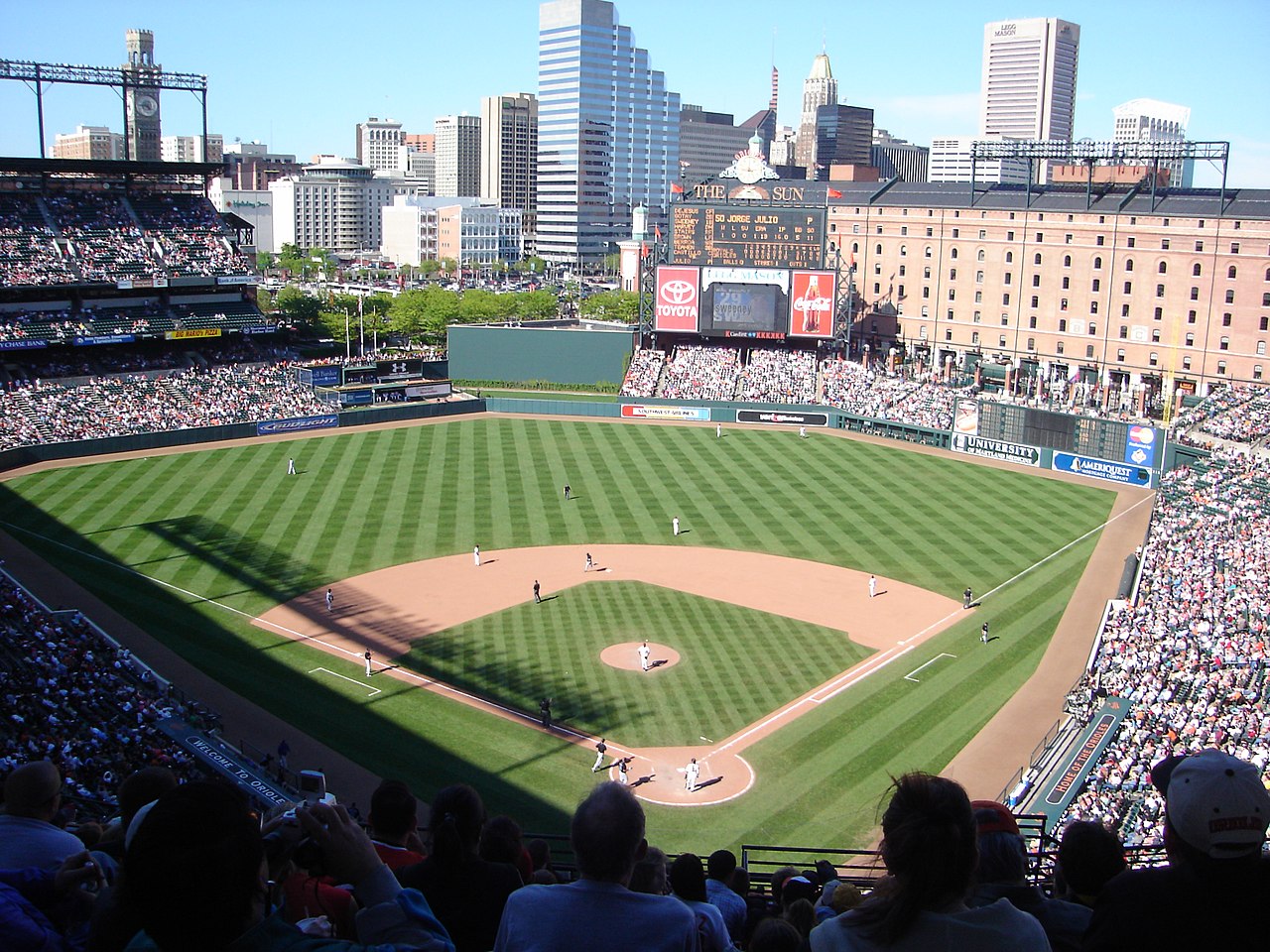

Maryland cuenta con dos áreas metropolitanas importantes y cuenta con varias franquicias deportivas profesionales importantes y menores. Dos equipos de la Liga Nacional de Fútbol Americano juegan en Maryland: los Baltimore Ravens en Baltimore y los Washington Commanders en Landover . Los Baltimore Colts representaron a la NFL en Baltimore desde 1953 hasta 1983 antes de mudarse a Indianápolis .
Los Baltimore Orioles son la franquicia de béisbol de las Grandes Ligas del estado . Los Washington Capitals de la Liga Nacional de Hockey y los Washington Wizards de la Asociación Nacional de Baloncesto jugaron anteriormente en Maryland, hasta la construcción de un estadio en Washington, DC en 1997 (ahora conocido como Capital One Arena ). El equipo de la Universidad de Maryland son los Maryland Terrapins .
Maryland goza de una considerable reputación histórica por los deportistas talentosos de su pasado, incluidos Cal Ripken Jr. y Babe Ruth . En 2012, The Baltimore Sun publicó una lista de los diez mejores atletas de Maryland en la historia del estado. La lista incluye a Babe Ruth, Cal Ripken Jr, Johnny Unitas , Brooks Robinson , Frank Robinson , Ray Lewis , Michael Phelps , Jimmie Foxx , Jim Parker y Wes Unseld . [216]
Otras franquicias deportivas profesionales en el estado incluyen tres equipos de béisbol de ligas menores afiliados, un equipo de béisbol de liga independiente , el equipo de fútbol de salón Baltimore Blast , dos equipos de fútbol de salón y tres equipos de fútbol al aire libre de nivel inferior. Maryland también es sede de una de las tres carreras de la Triple Corona anual de las carreras de caballos, la Preakness Stakes , que se corre cada primavera en el hipódromo de Pimlico en Baltimore. Los Baltimore Stallions fueron un equipo de fútbol canadiense en la CFL que jugó la temporada 1994-95.
El Congressional Country Club ha sido sede de tres torneos de golf: el Abierto de Estados Unidos y un Campeonato de la PGA .
El deporte oficial del estado de Maryland, desde 1962, es la justa ; el deporte oficial del equipo desde 2004 es el lacrosse . [217] El Salón Nacional de la Fama del Lacrosse se encuentra en Sparks, Maryland, en la sede de USA Lacrosse . En 2008, con la intención de promover la aptitud física para todas las edades, caminar se convirtió en el ejercicio oficial del estado. Maryland es el primer estado con un ejercicio estatal oficial. [218]
Maryland tiene relaciones con muchas provincias, estados y otras entidades en todo el mundo.
...
La sesión especial de 1937 de la Legislatura de Maryland impuso un impuesto sobre la renta
... gasto de fondos públicos en beneficio de personas físicamente aptas cuya incapacidad para mantenerse a sí mismas surge de la prevalencia del desempleo generalizado.
Superficie: comparativa: aproximadamente del tamaño de Maryland
Mapa que muestra
... provincias fisiográficas de Maryland
Históricamente, los linces rojos se distribuyeron por todo el estado, pero durante el período posterior a la colonización, las densidades comenzaron a desplomarse. A mediados de la década de 1900, las poblaciones probablemente habían alcanzado mínimos históricos, y solo existían poblaciones remanentes en el oeste de Maryland. Esto impulsó al Departamento de Recursos Naturales (DNR) a clasificarlos como una "especie de especial preocupación" en la lista estatal. Durante el último cuarto de siglo, el área de distribución ocupada y las densidades han aumentado notablemente. Los resultados de la encuesta anual Bowhunter Survey y la encuesta Hunter Mail han identificado avistamientos de linces rojos en 14 de los 23 condados de Maryland. Actualmente, los linces rojos tienen una clasificación legal dual en Maryland. Además de la designación de especie de especial preocupación, también se los define como animales de caza o de piel con una temporada de cosecha cerrada.
Los coyotes eran históricamente una especie occidental con poblaciones centrales que se encontraban al oeste del río Misisipi. Las alteraciones y/o eliminación de depredadores competidores durante el período posterior a la colonización europea facilitaron la rápida expansión de su área de distribución hacia el este de América del Norte durante el siglo XX. En la actualidad, existen poblaciones establecidas en todos los estados y provincias de América del Norte. Los coyotes son una incorporación relativamente nueva a los ecosistemas locales y se documentaron por primera vez en Maryland durante 1972. Los avistamientos iniciales confirmados ocurrieron en los condados de Cecil, Frederick y Washington. Desde entonces, las densidades de población y el área de distribución ocupada se han expandido de manera incremental y ahora los coyotes se encuentran en todo el estado.
Por otra parte, las zonas más allá de estos trece estados mantienen su cultura sureña en distintos grados. Gran parte de Missouri sigue siendo básicamente sureña, al igual que partes del sur de Maryland y la costa este de Maryland.
Kentucky, Missouri, Virginia Occidental y Maryland (estados y regiones esclavistas antes de la Guerra Civil que no se separaron de la Unión) también se incluyen a menudo como parte del Sur. Como estados fronterizos, estos estados siempre fueron una encrucijada de valores y costumbres, y hoy en día partes de Maryland parecen haberse convertido en parte del "Nordeste".
{{cite web}}: CS1 maint: nombres numéricos: lista de autores ( enlace )El condado de Prince George tiene el mayor porcentaje de hablantes de kru/ibo/yoruba de todos los condados del país.
El puerto de Baltimore maneja más automóviles que cualquier otro puerto de EE. UU.
En la actualidad, los 5.500 millones de dólares que Maryland gasta en educación representan aproximadamente el 40 por ciento del presupuesto del fondo general.
39°N 77°O / 39°N 77°O / 39; -77 (Estado de Maryland)