San Francisco , [25] oficialmente la Ciudad y Condado de San Francisco , es el centro comercial, financiero y cultural del norte de California . Con una población de 808,988 residentes en 2023, [16] San Francisco es la cuarta ciudad más poblada del estado estadounidense de California detrás de Los Ángeles , San Diego y San José . La ciudad cubre una superficie de 46,9 millas cuadradas (121 kilómetros cuadrados) [26] en el extremo superior de la península de San Francisco , lo que la convierte en la segunda ciudad importante más densamente poblada de EE. UU. detrás de la ciudad de Nueva York y el quinto condado más densamente poblado de EE. UU. , detrás de cuatro de los distritos de la ciudad de Nueva York . Entre las 92 ciudades de EE. UU. con más de 250 000 habitantes, San Francisco ocupa el primer lugar por ingresos per cápita y el sexto por ingresos agregados en 2022. [27] En 2023, el área metropolitana de San José, San Francisco y Oakland, California, es la quinta más grande del país, con una población aproximada de más de 9 001 024 habitantes.
Antes de la colonización europea , la ciudad moderna estaba habitada por los yelamu , que hablaban una lengua que ahora se conoce como ramaytush ohlone . El 29 de junio de 1776, los colonos de Nueva España establecieron el Presidio de San Francisco en el Golden Gate y la Misión de San Francisco de Asís a unas pocas millas de distancia, ambas llamadas así por Francisco de Asís . [4] La fiebre del oro de California de 1849 trajo consigo un rápido crecimiento, transformando una aldea sin importancia en un puerto activo, convirtiéndola en la ciudad más grande de la Costa Oeste en ese momento; entre 1870 y 1900, aproximadamente una cuarta parte de la población de California residía en la ciudad propiamente dicha. [27] En 1856, San Francisco se convirtió en una ciudad-condado consolidada . [28] Después de que tres cuartas partes de la ciudad fueran destruidas por el terremoto y el incendio de 1906 , [29] se reconstruyó rápidamente, albergando la Exposición Internacional Panamá-Pacífico nueve años después. En la Segunda Guerra Mundial , fue un importante puerto de embarque para los miembros del servicio naval que se dirigían al Teatro del Pacífico . [30] En 1945, se firmó la Carta de las Naciones Unidas en San Francisco, estableciendo las Naciones Unidas y en 1951, el Tratado de San Francisco restableció las relaciones pacíficas entre Japón y las Potencias Aliadas . [31] [32] [33] Después de la guerra, la confluencia de militares que regresaban, la inmigración significativa , las actitudes liberalizadoras, el surgimiento de las contraculturas beatnik e hippie , la revolución sexual , el movimiento por la paz que surgió de la oposición a la participación de los Estados Unidos en la Guerra de Vietnam y otros factores llevaron al Verano del Amor y al movimiento por los derechos de los homosexuales , consolidando a San Francisco como un centro de activismo liberal en los Estados Unidos .
San Francisco y el área circundante de la Bahía de San Francisco son un centro global de actividad económica y de artes y ciencias, [34] [35] impulsado por universidades líderes , [36] alta tecnología , atención médica, finanzas, seguros, bienes raíces y sectores de servicios profesionales. [37] A partir de 2020 [update], el área metropolitana, con 6,7 millones de residentes, ocupó el quinto lugar por PIB ($ 874 mil millones) y el segundo por PIB per cápita ($ 131,082) en los países de la OCDE , por delante de ciudades globales como París , Londres y Singapur . [38] [39] [40] San Francisco ancla la decimotercera área estadística metropolitana más poblada de los Estados Unidos con 4,6 millones de residentes, y la cuarta más grande por ingresos agregados y producción económica, con un PIB de $ 729 mil millones en 2022 [update]. [41] El área estadística combinada de San José-San Francisco-Oakland es la quinta más poblada del país, con alrededor de nueve millones de residentes, y la tercera más grande por producción económica, con un PIB de 1,32 billones de dólares en 2022. [update]En el mismo año, San Francisco propiamente dicho tenía un PIB de 252 200 millones de dólares y un PIB per cápita de 312 000 dólares. [41] San Francisco ocupaba el quinto lugar en el mundo y el segundo en los Estados Unidos en el Índice de centros financieros globales en septiembre de 2023. [update][ 42] A pesar de un continuo éxodo de empresas del centro de San Francisco, [43] [44] la ciudad todavía alberga numerosas empresas dentro y fuera de la tecnología, incluidas Salesforce , Uber , Airbnb , Levi's , Gap , Dropbox y Lyft .
En 2022, San Francisco tuvo más de 1,7 millones de visitantes internacionales (la quinta ciudad más visitada desde el extranjero en los Estados Unidos después de Nueva York, Miami , Orlando y Los Ángeles) y aproximadamente 20 millones de visitantes nacionales para un total de 21,9 millones de visitantes. [45] [46] La ciudad es conocida por sus empinadas colinas y su mezcla ecléctica de arquitectura en variados barrios , así como por sus veranos refrescantes, su niebla y sus lugares de interés notables, como el puente Golden Gate , los teleféricos y Alcatraz , junto con los distritos de Chinatown y Mission . [47] La ciudad alberga varias instituciones educativas y culturales, como la Universidad de California en San Francisco , la Universidad de San Francisco , la Universidad Estatal de San Francisco , el Conservatorio de Música de San Francisco , el Museo de Young , el Museo de Arte Moderno de San Francisco , la Sinfónica de San Francisco , el Ballet de San Francisco , la Ópera de San Francisco , el Centro SFJAZZ y la Academia de Ciencias de California . Dos equipos deportivos de las grandes ligas , los San Francisco Giants y los Golden State Warriors , juegan sus partidos como locales en San Francisco. El Aeropuerto Internacional de San Francisco (SFO) ofrece vuelos a más de 125 destinos, mientras que una red de trenes ligeros y autobuses , en conjunto con los sistemas BART y Caltrain , conectan casi todas las partes de San Francisco con la región en general. [48] [49]
San Francisco, que en español significa "San Francisco", toma su nombre de la Misión San Francisco de Asís , que a su vez recibió su nombre de San Francisco de Asís . La misión recibió su nombre en 1776, cuando fue fundada por los españoles bajo el liderazgo del Padre Francisco Palóu . La ciudad ha sido conocida oficialmente como San Francisco desde 1847, cuando Washington Allon Bartlett , que entonces se desempeñaba como alcalde de la ciudad , la rebautizó de Yerba Buena (en español, "buena hierba"), que había sido un nombre utilizado en las eras española y mexicana desde aproximadamente 1776. El nombre Yerba Buena continúa usándose en lugares de la ciudad, como en la isla Yerba Buena y en el Centro de las Artes Yerba Buena y los Jardines Yerba Buena .
Mientras que las personas que residen fuera del Área de la Bahía de San Francisco usan apodos como "Frisco" y "San Francisco", los residentes locales del Área de la Bahía a veces se refieren a San Francisco como "la Ciudad" o "SF". [1] [50] La elección del apodo que usa una persona es una forma común que tienen los locales de distinguir a los residentes de larga data de los turistas y los recién llegados. "San Francisco" y "Frisco" a veces se consideran apodos controvertidos entre los residentes de San Francisco. [51] [52] [50]
La evidencia arqueológica más temprana de habitación humana en el territorio de San Francisco data del año 3000 a. C. [53] El grupo Yelamu del pueblo Ramaytush residía en unas pocas aldeas pequeñas cuando un grupo de exploración española llegó por tierra el 2 de noviembre de 1769, la primera visita europea documentada a la Bahía de San Francisco . [54] El nombre Ohlone para San Francisco era Ahwaste , que significa "lugar en la bahía". [55] La llegada de los colonos españoles y la implementación de su sistema de misiones marcaron el comienzo del genocidio del pueblo Ramaytush y la privación de su lengua y cultura. [56] [57] [58]
.jpg/1280px-Victor_Adam_after_Louis_Choris_-_Vue_du_Presidio_san_Francisco,_1822_(cropped).jpg)
_(cropped).jpg/1280px-Mission_San_Francisco_de_As%C3%ADs_(Oriana_Day)_(cropped).jpg)
El Imperio español reclamó a San Francisco como parte de Las Californias , una provincia del Virreinato de Nueva España . Los españoles llegaron por primera vez a lo que hoy es San Francisco el 2 de noviembre de 1769, cuando la expedición de Portolá liderada por Don Gaspar de Portolá y Juan Crespí llegó a la bahía de San Francisco . Habiendo notado los beneficios estratégicos del área debido a su gran puerto natural, los españoles enviaron a Pedro Fages en 1770 para encontrar una ruta más directa a la península de San Francisco desde Monterey , que se convertiría en parte de la ruta de El Camino Real . En 1774, Juan Bautista de Anza había llegado al área para seleccionar los sitios para una misión y un presidio . La primera presencia marítima europea en la bahía de San Francisco ocurrió el 5 de agosto de 1775, cuando el barco español San Carlos , comandado por Juan Manuel de Ayala , se convirtió en el primer barco en anclar en la bahía. [59]
Poco después, el 28 de marzo de 1776, Anza estableció el Presidio de San Francisco . El 9 de octubre, la Misión San Francisco de Asís , también conocida como Misión Dolores, fue fundada por el Padre Francisco Palóu . [4] En 1794, el Presidio estableció el Castillo de San Joaquín , una fortificación en el lado sur del Golden Gate , que más tarde llegó a ser conocido como Fort Point.
En 1804 se creó la provincia de Alta California , que incluía a Yerba Buena , que era el antiguo nombre de San Francisco. En su apogeo, entre 1810 y 1820, la población media del asentamiento de Mission Dolores era de unas 1.100 personas. [60]
_(cropped).jpg/1280px-Do%C3%B1a_Juana_Briones_de_Miranda_(7222900876)_(cropped).jpg)
En 1821, España cedió las Californias a México . El extenso sistema de misiones de California fue perdiendo influencia gradualmente durante el período de dominio mexicano . Las tierras agrícolas se privatizaron en gran medida como ranchos , como estaba ocurriendo en otras partes de California. El comercio costero aumentó, incluyendo media docena de barcas de varios puertos del Atlántico que navegaban regularmente en aguas de California. [62] [63]
Yerba Buena (por una hierba nativa), un puesto comercial con asentamientos entre el Presidio y la Misión creció alrededor de la Plaza de Yerba Buena . La plaza fue rebautizada más tarde como Plaza Portsmouth (hoy situada en el barrio chino y distrito financiero de la ciudad ). El Presidio fue comandado en 1833 por el capitán Mariano G. Vallejo . [62]
En 1833, Juana Briones de Miranda construyó su rancho cerca del manantial El Polín , fundando así el primer hogar civil de San Francisco, que anteriormente sólo estaba compuesto por el asentamiento militar del Presidio y el asentamiento religioso de la Misión Dolores. [61]
En 1834, Francisco de Haro se convirtió en el primer alcalde de Yerba Buena. De Haro era originario de México, de la ciudad de Compostela, Nayarit , en la costa oeste de esa nación . Un estudio topográfico de Yerba Buena fue realizado por el inmigrante suizo Jean Jacques Vioget como preludio al plan de la ciudad. El segundo alcalde José Joaquín Estudillo era un californiano de una prominente familia de Monterey . En 1835, mientras estaba en el cargo, aprobó la primera concesión de tierras en Yerba Buena: a William Richardson , un ciudadano mexicano naturalizado de nacimiento inglés. Richardson había llegado a San Francisco a bordo de un barco ballenero en 1822. En 1825, se casó con María Antonia Martínez, la hija mayor del californiano Ygnacio Martínez . [64] [a]
._On_July_9,_1846,_Capt._Montgomery_of_the_Sloop_of_War_Portsmouth,_raised_the_American_Flag_in_the_plaza_and_seized_the_region_of_the_United_States_LCCN2004666425.jpg/1280px-thumbnail.jpg)
Yerba Buena comenzó a atraer colonos estadounidenses y europeos; un censo de 1842 enumeraba a 21 residentes (11%) nacidos en Estados Unidos o Europa, así como a un comerciante filipino. [65] Tras la Rebelión de la Bandera del Oso en Sonoma y el comienzo de la Conquista estadounidense de California , las fuerzas estadounidenses bajo el mando de John B. Montgomery capturaron Yerba Buena el 9 de julio de 1846, con poca resistencia de la población local de California. A finales de mes, el Brooklyn llegó con un grupo de colonos mormones, que habían partido de la ciudad de Nueva York seis meses antes. Tras la captura, las fuerzas estadounidenses designaron a José de Jesús Noé y Washington Allon Bartlett para que sirvieran como co- alcaldes , mientras la conquista continuaba en el resto de California. Tras el Tratado de Guadalupe Hidalgo en 1848, Alta California fue cedida de México a los Estados Unidos .

A pesar de su atractiva ubicación como puerto y base naval, después de la conquista, San Francisco seguía siendo un pequeño asentamiento con una geografía inhóspita. [66] Se decía que su población en 1847 era de 459 habitantes . [62]
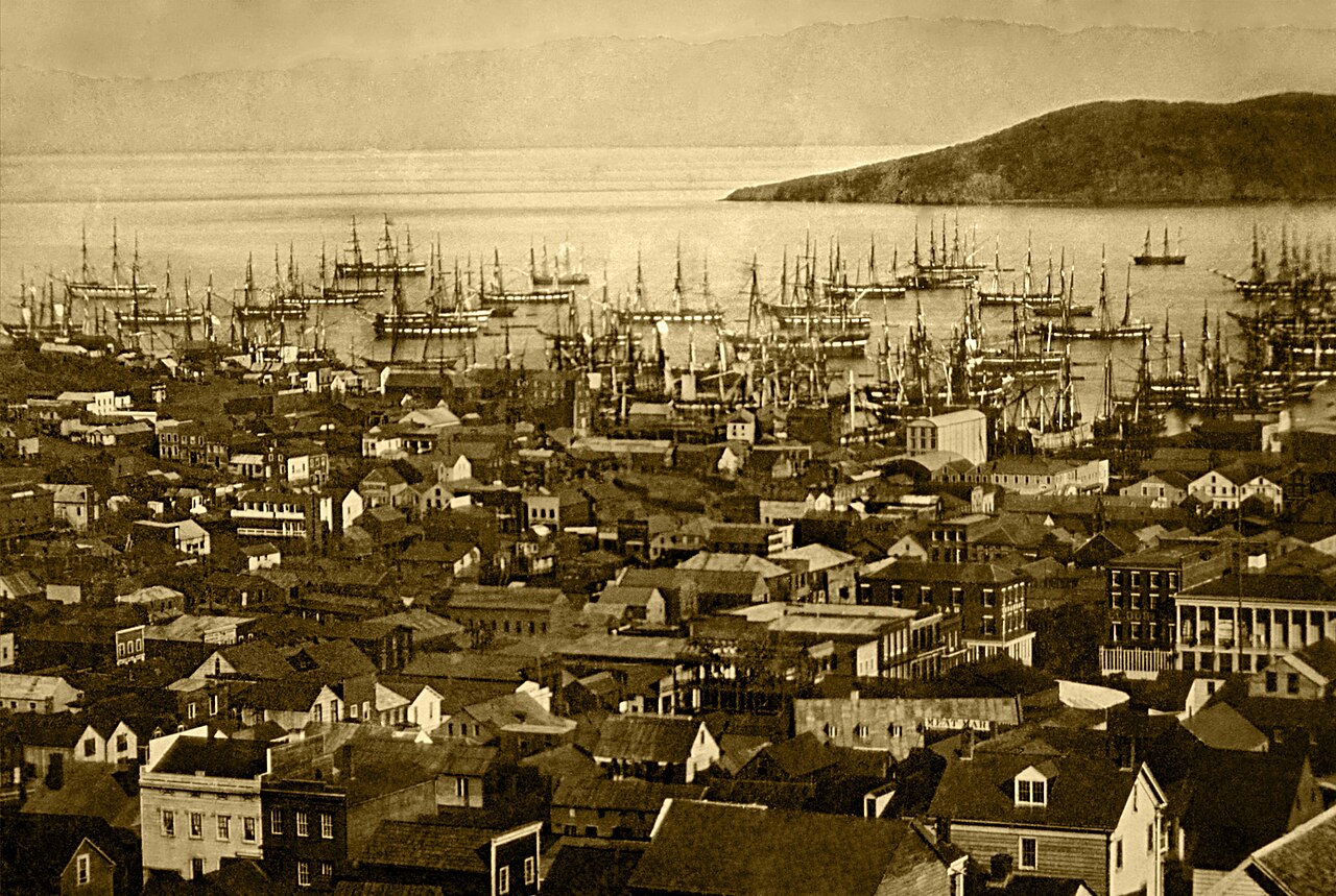
La fiebre del oro en California trajo consigo una oleada de buscadores de tesoros (conocidos como "cuarenta y nueve", como en "1849"). Con su pan de masa madre a cuestas, [67] los buscadores se acumularon en San Francisco sobre su rival Benicia , [68] aumentando la población de 1.000 en 1848 a 25.000 en diciembre de 1849. [69] La promesa de riqueza era tan fuerte que las tripulaciones de los barcos que llegaban desertaron y se apresuraron a ir a los yacimientos de oro, dejando atrás un bosque de mástiles en el puerto de San Francisco. [70] Algunos de estos aproximadamente 500 barcos abandonados se utilizaron en ocasiones como barcos de almacenamiento , salones y hoteles; muchos se dejaron pudrir y algunos se hundieron para establecer el título de propiedad del lote submarino. En 1851, el puerto se extendió hacia la bahía mediante muelles mientras se erigían edificios sobre pilotes entre los barcos. En 1870, la ensenada Yerba Buena se había rellenado para crear nueva tierra. Ocasionalmente, los barcos enterrados quedan expuestos cuando se cavan cimientos para nuevos edificios. [71]
En 1850, California obtuvo rápidamente la condición de estado y el ejército estadounidense construyó Fort Point en el Golden Gate y un fuerte en la isla de Alcatraz para proteger la bahía de San Francisco. El condado de San Francisco fue uno de los 18 condados originales del estado establecidos en la condición de estado de California en 1850. [72] Hasta 1856, los límites de la ciudad de San Francisco se extendían al oeste hasta Divisadero Street y Castro Street, y al sur hasta 20th Street. En 1856, el gobierno del estado de California dividió el condado. Luego se trazó una línea recta a través de la punta de la península de San Francisco, justo al norte de la montaña de San Bruno . Todo lo que estuviera al sur de la línea se convirtió en el nuevo condado de San Mateo, mientras que todo lo que estuviera al norte de la línea se convirtió en la nueva ciudad y condado consolidados de San Francisco. [73]
.jpg/1280px-Bank_of_California_Building_San_Francisco_(cropped).jpg)
La fiebre del oro en California desencadenó una ola de actividad empresarial, en la que los individuos buscaban sacar provecho de la nueva riqueza. El descubrimiento de yacimientos de plata, en particular la veta Comstock en Nevada en 1859, impulsó aún más el rápido crecimiento demográfico y la expansión económica. [75]
San Francisco, como puerta de entrada a los yacimientos de oro, experimentó un aumento de la población y la actividad comercial. Sin embargo, la afluencia de buscadores de fortuna también trajo consigo desafíos. La anarquía era rampante y el distrito de Barbary Coast se convirtió en sinónimo de vicio, atrayendo a criminales, prostitutas y actividades ilícitas, incluidas, entre otras, la prostitución, el contrabando y el juego. [76]
Una de las figuras más influyentes de esta era fue William Chapman Ralston . Un astuto banquero e inversor, Ralston amasó una considerable riqueza e influencia en San Francisco. Obtuvo el control sobre una parte significativa de las minas de oro y plata de Comstock Lode , estableciendo un monopolio virtual. Usando su increíble influencia, Ralston fue capaz de generar millones de dólares para San Francisco durante sus vertiginosos años de auge. [77] Fundó el Bank of California , el primer banco en el oeste de los Estados Unidos, y construyó el opulento Palace Hotel, un símbolo de la nueva prosperidad de San Francisco y el hotel más grande del país en ese momento. [78] Su imperio financiero, sin embargo, se derrumbó en 1875 como resultado del Pánico de 1873 , lo que desencadenó una importante crisis económica en San Francisco.
El desarrollo del puerto de San Francisco y el establecimiento en 1869 de un acceso terrestre al sistema ferroviario del este de los EE. UU. a través del recién terminado Ferrocarril del Pacífico (cuya construcción la ciudad sólo ayudó a financiar a regañadientes [79] ) ayudaron a hacer del Área de la Bahía un centro de comercio. Para satisfacer las necesidades y los gustos de la creciente población, Levi Strauss abrió un negocio de artículos secos y Domingo Ghirardelli comenzó a fabricar chocolate. Los inmigrantes chinos convirtieron la ciudad en una cultura políglota, atraídos por la "Old Gold Mountain", y crearon el barrio chino de la ciudad . En 1880, los chinos constituían el 9,3% de la población. [80]
.jpg/1280px-The_City_of_San_Francisco,_panorama_by_Currier_&_Ives,_1878_(cropped).jpg)
Los primeros tranvías transportaron a los habitantes de San Francisco por Clay Street en 1873. El mar de casas victorianas de la ciudad comenzó a tomar forma y los líderes cívicos hicieron campaña por un espacioso parque público, lo que resultó en planes para el Golden Gate Park . Los habitantes de San Francisco construyeron escuelas, iglesias, teatros y todos los distintivos de la vida cívica. El Presidio se convirtió en la instalación militar estadounidense más importante de la costa del Pacífico. [81] En 1890, la población de San Francisco se acercaba a los 300.000 habitantes, lo que la convirtió en la octava ciudad más grande de los Estados Unidos en ese momento. Alrededor de 1901, San Francisco era una ciudad importante conocida por su estilo extravagante, sus majestuosos hoteles, sus ostentosas mansiones en Nob Hill y una próspera escena artística. [82] La primera epidemia de peste de América del Norte fue la peste de San Francisco de 1900-1904 . [83]

A las 5:12 am del 18 de abril de 1906, un gran terremoto golpeó San Francisco y el norte de California. Mientras los edificios se derrumbaban por el temblor, las tuberías de gas rotas provocaron incendios que se extendieron por toda la ciudad y ardieron sin control durante varios días. Con las tuberías principales de agua fuera de servicio, el Cuerpo de Artillería del Presidio intentó contener el infierno dinamitando bloques de edificios para crear cortafuegos. [84] Más de las tres cuartas partes de la ciudad estaban en ruinas, incluida casi la totalidad del centro de la ciudad. [29] Los relatos contemporáneos informaron que murieron 498 personas, aunque las estimaciones modernas elevan la cifra a varios miles. [85] Más de la mitad de la población de la ciudad, de 400.000 personas, se quedó sin hogar. [86] Los refugiados se establecieron temporalmente en aldeas de tiendas de campaña improvisadas en el Golden Gate Park, el Presidio, en las playas y en otros lugares. Muchos huyeron de forma permanente a East Bay . Se recuerda a Jack London por haber elogiado el terremoto: "Nunca en la historia una ciudad imperial moderna ha sido destruida tan completamente. San Francisco ha desaparecido". [87]
.jpg/1280px-General_View_of_Civic_Center_and_New_City_Hall_(Engineering_News-Record,_vol_75_no_26_p_1222_fig_2).jpg)
La reconstrucción fue rápida y se llevó a cabo a gran escala. Rechazando los llamados a rehacer completamente la cuadrícula de calles, los habitantes de San Francisco optaron por la velocidad. [88] El Banco de Italia de Amadeo Giannini , que luego se convertiría en el Banco de América , proporcionó préstamos a muchas de las personas cuyos medios de vida habían sido devastados. La influyente Asociación de Planificación e Investigación Urbana de San Francisco o SPUR se fundó en 1910 para abordar la calidad de la vivienda después del terremoto. [89] El terremoto aceleró el desarrollo de los barrios occidentales que sobrevivieron al incendio, incluido Pacific Heights , donde muchos de los ricos de la ciudad reconstruyeron sus hogares. [90] A su vez, las mansiones destruidas de Nob Hill se convirtieron en grandes hoteles. El Ayuntamiento se levantó de nuevo en estilo Beaux Arts , y la ciudad celebró su renacimiento en la Exposición Internacional Panamá-Pacífico en 1915. [91]

Durante este período, San Francisco construyó algunas de sus infraestructuras más importantes. El ingeniero civil Michael O'Shaughnessy fue contratado por el alcalde de San Francisco, James Rolph, como ingeniero jefe de la ciudad en septiembre de 1912 para supervisar la construcción del embalse Twin Peaks, el túnel de Stockton Street , el túnel Twin Peaks , el ferrocarril municipal de San Francisco , el sistema auxiliar de suministro de agua y nuevas alcantarillas. El sistema de tranvía de San Francisco, del que sobreviven hoy en día las líneas J , K , L , M y N , fue completado por O'Shaughnessy entre 1915 y 1927. Fueron la presa O'Shaughnessy , el embalse Hetch Hetchy y el acueducto Hetch Hetchy los que tendrían el mayor efecto en San Francisco. [92] Un suministro de agua abundante permitió que San Francisco se desarrollara hasta convertirse en la ciudad que es hoy.

En los años siguientes, la ciudad consolidó su posición como capital financiera; a raíz de la crisis bursátil de 1929 , ningún banco con sede en San Francisco quebró. [93] De hecho, fue en el apogeo de la Gran Depresión que San Francisco emprendió dos grandes proyectos de ingeniería civil, construyendo simultáneamente el Puente de la Bahía de San Francisco-Oakland y el Puente Golden Gate , completándolos en 1936 y 1937, respectivamente. Fue en este período que la isla de Alcatraz , una antigua empalizada militar, comenzó a funcionar como prisión federal de máxima seguridad, albergando a reclusos notorios como Al Capone y Robert Franklin Stroud , el Hombre Pájaro de Alcatraz. San Francisco celebró más tarde su grandeza recuperada con una feria mundial , la Exposición Internacional Golden Gate en 1939-40, creando la Isla del Tesoro en medio de la bahía para albergarla. [94]
_van_der_Plas_en_andere_leden_van_de_Nederlandse_delegatie_het_handvast_van_de_Uni,_KITLV_403000.tiff/lossy-page1-1280px-thumbnail.tiff.jpg)
Durante la Segunda Guerra Mundial , el Sharp Park, propiedad de la ciudad , en Pacifica se utilizó como campo de internamiento para detener a los estadounidenses de origen japonés . [95] El Astillero Naval de Hunters Point se convirtió en un centro de actividad y Fort Mason se convirtió en el principal puerto de embarque para los miembros del servicio que se enviaban al Teatro de Operaciones del Pacífico . [30] La explosión de puestos de trabajo atrajo a mucha gente, especialmente a afroamericanos del sur , a la zona. Después del final de la guerra, muchos militares que regresaban del servicio en el extranjero y civiles que originalmente habían venido a trabajar decidieron quedarse. La Carta de las Naciones Unidas que creó las Naciones Unidas se redactó y firmó en San Francisco en 1945 y, en 1951, el Tratado de San Francisco restableció las relaciones pacíficas entre Japón y las Potencias Aliadas . [96]
Los proyectos de planificación urbana de los años 1950 y 1960 implicaron la destrucción generalizada y la reurbanización de los barrios del lado oeste y la construcción de nuevas autopistas , de las cuales solo se construyeron una serie de segmentos cortos antes de ser detenidos por la oposición ciudadana . [97] El inicio de la contenerización hizo que los pequeños muelles de San Francisco quedaran obsoletos y la actividad de carga se trasladó al puerto más grande de Oakland . [98] La ciudad comenzó a perder empleos industriales y se volcó al turismo como el segmento más importante de su economía. [99] Los suburbios experimentaron un rápido crecimiento y San Francisco experimentó un cambio demográfico significativo, ya que grandes segmentos de la población blanca abandonaron la ciudad, suplantados por una creciente ola de inmigración de Asia y América Latina. [100] [101] De 1950 a 1980, la ciudad perdió más del 10 por ciento de su población.

Durante este período, San Francisco se convirtió en un imán para el movimiento de contracultura de Estados Unidos . Los escritores de la Generación Beat impulsaron el Renacimiento de San Francisco y se centraron en el barrio de North Beach en la década de 1950. [102] Los hippies acudieron en masa a Haight-Ashbury en la década de 1960, alcanzando un pico con el Verano del Amor de 1967. [103] En 1974, los asesinatos de Zebra dejaron al menos 16 personas muertas. [104] En la década de 1970, la ciudad se convirtió en un centro del movimiento por los derechos de los homosexuales , con el surgimiento de The Castro como un pueblo gay urbano , la elección de Harvey Milk para la Junta de Supervisores y su asesinato , junto con el del alcalde George Moscone , en 1978. [105]
Bank of America , con sede en Charlotte , Carolina del Norte , fue fundado en San Francisco; el banco completó la construcción de 555 California Street en 1969. La Pirámide Transamerica se completó en 1972, [106] lo que desencadenó una ola de " manhattanización " que duró hasta fines de los años 1980, un período de desarrollo extensivo de edificios de gran altura en el centro de la ciudad. [107] La década de 1980 también vio un aumento dramático en el número de personas sin hogar en la ciudad, un problema que persiste hoy en día, a pesar de los muchos intentos de abordarlo. [108]
El terremoto de Loma Prieta de 1989 causó destrucción y pérdida de vidas en toda la zona de la Bahía. En San Francisco, el terremoto dañó gravemente las estructuras de los distritos de Marina y South of Market y precipitó la demolición de la autopista Embarcadero dañada y gran parte de la autopista Central dañada , lo que permitió a la ciudad recuperar el Embarcadero como su zona costera histórica del centro y revitalizar el barrio de Hayes Valley . [109]
En las últimas dos décadas se han producido auges impulsados por la industria de Internet. Durante el auge de las puntocom de finales de los años 1990, las empresas emergentes dinamizaron la economía de San Francisco. Un gran número de empresarios y desarrolladores de aplicaciones informáticas se trasladaron a la ciudad, seguidos de profesionales del marketing, el diseño y las ventas, lo que cambió el panorama social a medida que los barrios antaño más pobres se iban gentrificando cada vez más . [110] La demanda de nuevas viviendas y espacios de oficina desencadenó una segunda oleada de desarrollo de edificios de gran altura, esta vez en el distrito de South of Market. [111] En 2000, la población de la ciudad alcanzó nuevos máximos, superando el récord anterior establecido en 1950. Cuando la burbuja estalló en 2001 y de nuevo en 2023, muchas de estas empresas cerraron y sus empleados fueron despedidos. Sin embargo, la alta tecnología y el espíritu emprendedor siguen siendo pilares de la economía de San Francisco. A mediados de la década de 2000, el auge de las redes sociales había comenzado, y San Francisco se convirtió en un lugar popular para las oficinas de tecnología y un lugar común para vivir para las personas empleadas en empresas de Silicon Valley como Apple y Google . [112]
A principios de la década de 2020, las empresas tecnológicas abandonaron el centro de San Francisco a raíz de la pandemia de COVID-19 y de las dificultades para hacer frente a la falta de vivienda y el consumo de drogas en la vía pública. Aunque algunos observadores han planteado la posibilidad de que las vacantes de oficinas y la disminución de los ingresos fiscales pudieran hacer que San Francisco entrara en un círculo vicioso económico , [113] [114] otras fuentes han refutado esta caracterización generalizada de la ciudad en su conjunto, afirmando que los problemas que preocupan se limitan principalmente al núcleo urbano de San Francisco. [43] [115] En marzo de 2024, Union Square se encontraba en "lamentable estado" y había perdido su posición tradicional como centro comercial regional del Área de la Bahía [116] en favor de Westfield Valley Fair en San José. [117]
El edificio de correos de la estación de Ferry , el edificio Armour & Co. , Atherton House y el hotel YMCA son edificios históricos entre las docenas de monumentos históricos de la ciudad, según los listados del Registro Nacional de Lugares Históricos de San Francisco . [118]
.jpg/1280px-San_Francisco_Peninsula_by_Sentinel-2,_2019-03-11_(cropped).jpg)
San Francisco está situada en la costa oeste de los Estados Unidos , en el extremo norte de la península de San Francisco e incluye importantes extensiones del océano Pacífico y la bahía de San Francisco dentro de sus límites. Varias islas pintorescas ( Alcatraz , Treasure Island y la adyacente isla Yerba Buena , y pequeñas porciones de la isla Alameda , la isla Red Rock y la isla Angel ) forman parte de la ciudad. También se incluyen las deshabitadas islas Farallón , a 43 km de la costa en el océano Pacífico. El continente dentro de los límites de la ciudad forma aproximadamente un "cuadrado de siete por siete millas", un coloquialismo local común que se refiere a la forma de la ciudad, aunque su área total, incluida el agua, es de casi 600 km² .
Hay más de 50 colinas dentro de los límites de la ciudad. [119] Algunos barrios reciben el nombre de la colina en la que están situados, incluyendo Nob Hill , Potrero Hill y Russian Hill . Cerca del centro geográfico de la ciudad, al suroeste del centro de la ciudad, hay una serie de colinas menos densamente pobladas. Twin Peaks , un par de colinas que forman uno de los puntos más altos de la ciudad, forma un mirador. La colina más alta de San Francisco, Mount Davidson , tiene 928 pies (283 m) de altura y está coronada por una cruz de 103 pies (31 m) de altura construida en 1934. [120] Dominando esta zona se encuentra Sutro Tower , una gran torre de transmisión de radio y televisión roja y blanca que alcanza los 1.811 pies (552 m) sobre el nivel del mar.
.jpg/1280px-Lake_Merced_Park,_Fort_Funston,_and_SF_Zoo_(cropped).jpg)
Las fallas de San Andrés y Hayward, que se encuentran cerca de la ciudad , son responsables de gran parte de la actividad sísmica, aunque ninguna de ellas atraviesa físicamente la ciudad. La falla de San Andrés causó los terremotos de 1906 y 1989. Los terremotos menores ocurren con regularidad. La amenaza de terremotos importantes desempeña un papel importante en el desarrollo de la infraestructura de la ciudad. La ciudad construyó un sistema auxiliar de suministro de agua y ha actualizado repetidamente sus códigos de construcción, lo que exige reformas para los edificios más antiguos y estándares de ingeniería más altos para las nuevas construcciones. [121] Sin embargo, todavía hay miles de edificios más pequeños que siguen siendo vulnerables a los daños causados por los terremotos. [122] El Servicio Geológico de los Estados Unidos ha publicado el pronóstico de terremotos de California , que modela la ocurrencia de terremotos en California. [123]
La línea costera de San Francisco ha crecido más allá de sus límites naturales. Barrios enteros como Marina , Mission Bay y Hunters Point , así como grandes secciones del Embarcadero , se asientan sobre áreas de vertedero . Treasure Island se construyó a partir de material dragado de la bahía, así como material resultante de la excavación del Túnel Yerba Buena a través de la Isla Yerba Buena durante la construcción del Puente de la Bahía. Dicho terreno tiende a ser inestable durante los terremotos. La licuefacción del suelo resultante causa grandes daños a las propiedades construidas sobre él, como se evidenció en el distrito de Marina durante el terremoto de Loma Prieta de 1989. [ 124] Algunos lagos y arroyos naturales ( lago Merced , lago Mountain , lago Pine , arroyo Lobos , manantial El Polin ) se encuentran dentro de parques y permanecen protegidos en lo que es esencialmente su forma original, pero la mayoría de los cursos de agua naturales de la ciudad, como Islais Creek y Mission Creek , han sido parcial o completamente entubados y construidos. Sin embargo, desde la década de 1990, la Comisión de Servicios Públicos ha estado estudiando propuestas para aclarar o restaurar algunos arroyos. [125]

El centro histórico de San Francisco es el cuadrante noreste de la ciudad, anclado por Market Street y el paseo marítimo. Aquí se centra el Distrito Financiero , con Union Square , el principal distrito comercial y hotelero, y el Tenderloin cerca. Los tranvías llevan a los pasajeros por empinadas pendientes hasta la cima de Nob Hill , antaño el hogar de los magnates empresariales de la ciudad, y hasta las atracciones turísticas frente al mar de Fisherman's Wharf y Pier 39 , donde muchos restaurantes ofrecen cangrejo Dungeness de una industria pesquera aún activa. También en este cuadrante se encuentran Russian Hill , un barrio residencial con la famosa Lombard Street ; North Beach , la Little Italy de la ciudad y antiguo centro de la Generación Beat ; y Telegraph Hill , donde se encuentra la Torre Coit . Colindante con Russian Hill y North Beach se encuentra el Chinatown de San Francisco , el barrio chino más antiguo de Norteamérica. [126] [127] [128] [129] El South of Market , que alguna vez fue el núcleo industrial de San Francisco, ha experimentado una importante remodelación tras la construcción de Oracle Park y una infusión de empresas emergentes . Nuevos rascacielos, lofts para vivir y trabajar y condominios salpican el área. Se están llevando a cabo más desarrollos justo al sur en el área de Mission Bay , un antiguo patio de ferrocarril, que ahora tiene un segundo campus de la Universidad de California, San Francisco y Chase Center , que abrió en 2019 como el nuevo hogar de los Golden State Warriors . [130]
Al oeste del centro, al otro lado de la avenida Van Ness , se encuentra el gran barrio Western Addition , que se estableció con una gran población afroamericana después de la Segunda Guerra Mundial . Western Addition suele dividirse en barrios más pequeños, entre ellos Hayes Valley , Fillmore y Japantown , que alguna vez fue el Japantown más grande de América del Norte, pero sufrió cuando sus residentes estadounidenses de origen japonés fueron expulsados a la fuerza e internados durante la Segunda Guerra Mundial. Western Addition sobrevivió al terremoto de 1906 con sus victorianos prácticamente intactos, incluidas las famosas " Damas pintadas ", que se encuentran junto a Alamo Square . Al sur, cerca del centro geográfico de la ciudad, se encuentra Haight-Ashbury , famosa por su asociación con la cultura hippie de los años 60. [131] Haight es ahora [¿ período de tiempo? ] el hogar de algunas boutiques caras [132] [ se necesita una mejor fuente ] y algunas cadenas de tiendas controvertidas, [133] aunque todavía conserva [ ¿período de tiempo? ] [ cita requerida ] cierto carácter bohemio .
.jpg/1280px-SF_Chinatown_CA_(cropped).jpg)
Al norte de Western Addition se encuentra Pacific Heights , un barrio adinerado que cuenta con las casas construidas por los ricos de San Francisco a raíz del terremoto de 1906. Directamente al norte de Pacific Heights, frente a la costa, se encuentra Marina , un barrio popular entre los jóvenes profesionales que se construyó en gran parte sobre tierras recuperadas de la bahía. [134]
En el cuadrante sureste de la ciudad se encuentra el Distrito de la Misión , poblado en el siglo XIX por californianos e inmigrantes de clase trabajadora de Alemania, Irlanda, Italia y Escandinavia. En la década de 1910, una ola de inmigrantes centroamericanos se instaló en la Misión y, en la década de 1950, los inmigrantes de México comenzaron a predominar. [135] En los últimos años, la gentrificación ha cambiado la demografía de partes de la Misión de latinos a profesionales de veintitantos años . Noe Valley al suroeste y Bernal Heights al sur son cada vez más populares entre las familias jóvenes con niños. Al este de la Misión se encuentra el vecindario de Potrero Hill , un vecindario principalmente residencial que cuenta con vistas panorámicas del centro de San Francisco. Al oeste de la Misión, el área históricamente conocida como Eureka Valley , ahora popularmente llamada Castro , alguna vez fue un área de clase trabajadora escandinava e irlandesa. Se ha convertido en el primer pueblo gay de América del Norte y ahora es el centro de la vida gay en la ciudad. [136] Ubicado cerca del límite sur de la ciudad, el Distrito Excelsior es uno de los barrios con mayor diversidad étnica de San Francisco. El Bayview-Hunters Point, en el extremo sureste de la ciudad, es uno de los barrios más pobres, aunque la zona ha sido el foco de varios proyectos de revitalización y renovación urbana .

La construcción del túnel Twin Peaks en 1918 conectó los barrios del suroeste con el centro de la ciudad a través del tranvía, acelerando el desarrollo de West Portal y de los afluentes barrios de Forest Hill y St. Francis Wood . Más al oeste, extendiéndose hasta el Océano Pacífico y al norte hasta el Golden Gate Park , se encuentra el vasto Sunset District , una gran zona de clase media con una población predominantemente asiática. [137]
El cuadrante noroeste de la ciudad contiene Richmond , un barrio mayoritariamente de clase media al norte del Golden Gate Park, hogar de inmigrantes de otras partes de Asia, así como de muchos inmigrantes rusos y ucranianos . Juntas, estas áreas se conocen como The Avenues . Estos dos distritos a veces se dividen en dos regiones: Outer Richmond y Outer Sunset pueden referirse a las partes más occidentales de su respectivo distrito y Inner Richmond e Inner Sunset pueden referirse a las partes más orientales.
Muchos muelles permanecieron abandonados durante años hasta que la demolición de la autopista Embarcadero reabrió el paseo marítimo del centro de la ciudad, lo que permitió su renovación. El Ferry Building , el elemento central del puerto , aunque todavía recibe tráfico de transbordadores de pasajeros, ha sido restaurado y rehabilitado como un mercado gourmet.

San Francisco tiene un clima mediterráneo de veranos cálidos ( Köppen : Csb , Trewartha : Csll), característico de la costa de California, con inviernos húmedos y veranos secos. [138] El clima de San Francisco está fuertemente influenciado por las corrientes frías del Océano Pacífico en el lado oeste de la ciudad, y el agua de la Bahía de San Francisco al norte y al este. Esto modera las oscilaciones de temperatura y produce un clima notablemente templado durante todo el año con poca variación de temperatura estacional. [139]
Entre las principales ciudades de EE. UU., San Francisco tiene las temperaturas medias, máximas y mínimas diarias más frías para junio, julio y agosto. [140] Durante el verano, el aire caliente ascendente en los valles interiores de California crea un área de baja presión que atrae vientos de la Alta del Pacífico Norte a través del Golden Gate , lo que crea los vientos fríos y la niebla característicos de la ciudad . [141] La niebla es menos pronunciada en los vecindarios del este y durante finales del verano y principios del otoño. Como resultado, el mes más cálido del año, en promedio, es septiembre y, en promedio, octubre es más cálido que julio, especialmente durante el día.
Las temperaturas alcanzan o superan los 80 °F (27 °C) en un promedio de solo 21 y 23 días al año en el centro de la ciudad y el Aeropuerto Internacional de San Francisco (SFO), respectivamente. [142] El período seco de mayo a octubre es templado a cálido, con una temperatura media mensual normal que alcanza su punto máximo en septiembre con 62,7 °F (17,1 °C). [142] El período lluvioso de noviembre a abril es ligeramente más frío, con una temperatura media mensual normal que alcanza su punto más bajo en enero con 51,3 °F (10,7 °C). [142] En promedio, hay 73 días lluviosos al año y la precipitación anual promedia 23,65 pulgadas (601 mm). [142] La variación en la precipitación de un año a otro es alta. Los años de lluvia superior a la media a menudo se asocian con condiciones cálidas de El Niño en el Pacífico, mientras que los años secos a menudo ocurren en períodos de La Niña de agua fría. En 2013 (un año de "La Niña"), se registró un récord de 142 mm (5,59 pulgadas) de lluvia en el centro de San Francisco, donde se llevan registros desde 1849. [142] Las nevadas en la ciudad son muy raras, con solo 10 acumulaciones mensurables registradas desde 1852, la más reciente en 1976, cuando cayeron hasta 13 cm (5 pulgadas) en Twin Peaks. [143] [144]

La temperatura más alta registrada en la estación de observación oficial del Servicio Meteorológico Nacional en el centro de la ciudad [b] fue de 106 °F (41 °C) el 1 de septiembre de 2017. [146] Durante esa ola de calor, también se registró la noche más cálida de la historia, de 71 °F (22 °C). [147] La temperatura más baja registrada fue de 27 °F (−3 °C) el 11 de diciembre de 1932. [148]
Durante un año promedio entre 1991 y 2020, San Francisco registró una noche más cálida de 18 °C (64 °F) y un día más frío de 9 °C (49 °F). [142] La temperatura máxima diurna más fría desde la apertura de la estación en 1945 se registró en diciembre de 1972 con 37 °F (3 °C). [142]
Como ciudad costera, San Francisco se verá muy afectada por el cambio climático . A partir de 2021 [update], se prevé que el nivel del mar aumente hasta 1,5 m, lo que provocará inundaciones periódicas, aumento del nivel de las aguas subterráneas e inundaciones en las tierras bajas debido a tormentas más severas. [149]
San Francisco se encuentra dentro de la zona de rusticidad de plantas 10b del USDA , aunque algunas áreas, particularmente el centro, limitan con la zona 11a. [150] [151]

Históricamente, el alce tule estaba presente en el condado de San Francisco, según la evidencia arqueológica de restos de alces en al menos cinco montículos de conchas de nativos americanos diferentes : en Hunter's Point, Fort Mason, Stevenson Street, Market Street y Yerba Buena. [157] [158] Quizás el primer registro histórico de un observador fue el de la Expedición De Anza del 23 de marzo de 1776. Herbert Eugene Bolton escribió sobre el campamento de la expedición en Mountain Lake, cerca del extremo sur del actual Presidio : "Alrededor pastaban ciervos, y esparcidas aquí y allá estaban las astas de grandes alces". [159] Además, cuando Richard Henry Dana Jr. visitó la bahía de San Francisco en 1835, escribió sobre grandes manadas de alces cerca del Golden Gate: el 27 de diciembre "... llegamos a fondear cerca de la boca de la bahía, bajo una colina alta y hermosamente inclinada, sobre la que había manadas de cientos y cientos de ciervos rojos [nota: "ciervo rojo" es el término europeo para "alce"], y el ciervo, con sus altas astas ramificadas, saltaban de un lado a otro...", aunque no está claro si se trataba del lado de Marin o del lado de San Francisco. [160]
El censo de los Estados Unidos de 2020 mostró que la población de San Francisco era de 873.965, un aumento del 8,5% con respecto al censo de 2010. [ 16] Con aproximadamente una cuarta parte de la densidad de población de Manhattan , San Francisco es la segunda ciudad estadounidense grande más densamente poblada , solo detrás de la ciudad de Nueva York entre las ciudades de más de 200.000 habitantes, y el quinto condado estadounidense más densamente poblado , después de solo cuatro de los cinco distritos de la ciudad de Nueva York .
San Francisco es parte del Área Estadística Metropolitana de cinco condados de San Francisco-Oakland-Hayward, CA , una región de 4,7 millones de personas ( la 13.ª más poblada de los EE. UU. ), y ha servido como su foco demográfico tradicional. También es parte del Área Estadística Combinada de 14 condados de San José-San Francisco-Oakland, CA , cuya población es de más de 9,6 millones, lo que la convierte en la quinta más grande de los Estados Unidos en 2018. [update][ 161] [ verificación fallida ]

Según el [update]censo de 2020, la composición racial y la población de San Francisco incluían: 361.382 blancos (41,3 %), 296.505 asiáticos (33,9 %), 46.725 afroamericanos (5,3 %), 86.233 estadounidenses multirraciales (9,9 %), 6.475 nativos americanos y nativos de Alaska (0,7 %), 3.476 nativos hawaianos y otras islas del Pacífico (0,4 %) y 73.169 personas de otras razas (8,4 %). Había 136.761 residentes hispanos o latinos de cualquier raza (15,6 %).
San Francisco es una ciudad con mayoría minoritaria , ya que los residentes blancos no hispanos representan menos de la mitad de la población; en 1940 formaban el 92,5% de la población. [162]
En 2010, los residentes de etnia china constituían el grupo minoritario étnico más grande en San Francisco con un 21% de la población; otros grandes grupos asiáticos incluyen filipinos (5%) y vietnamitas (2%), con japoneses , coreanos y muchos otros grupos asiáticos e isleños del Pacífico representados en la ciudad. [163] La población de ascendencia china está más concentrada en Chinatown y los distritos Sunset y Richmond . Los filipinos están más concentrados en SoMa y Crocker-Amazon ; este último vecindario comparte frontera con Daly City , que tiene una de las mayores concentraciones de filipinos en América del Norte. [163] [164] El distrito Tenderloin alberga una gran parte de la población vietnamita de la ciudad, así como empresas y restaurantes, que se conoce como el Pequeño Saigón de la ciudad. [163]
Los principales grupos hispanos de la ciudad eran los de ascendencia mexicana (7%) y salvadoreña (2%). La población hispana está más concentrada en el Distrito de la Misión , el Distrito de Tenderloin y el Distrito de Excelsior . [165] El porcentaje de residentes hispanos de la ciudad es menos de la mitad del del estado.
Los afroamericanos constituían aproximadamente el 5% de la población de San Francisco en 2020; su proporción en la población de la ciudad ha estado disminuyendo desde la década de 1970. [166] La mayoría de los residentes negros de la ciudad viven en los vecindarios de Bayview-Hunters Point , Visitacion Valley y Fillmore District . [165] Hay comunidades negras más pequeñas en Diamond Heights , Glen Park y Mission District .
La ciudad ha sido durante mucho tiempo el hogar de una importante comunidad judía; en 2018, los judíos estadounidenses representaban aproximadamente el 10% (80.000) de la población de la ciudad. Es la tercera comunidad judía más grande en términos proporcionales en los Estados Unidos, solo detrás de las de la ciudad de Nueva York y Los Ángeles, respectivamente, y también es relativamente joven en comparación con otras ciudades importantes de EE. UU. [167] La comunidad judía reside en toda la ciudad, pero el distrito de Richmond alberga un enclave étnico de judíos principalmente rusos . [168] El distrito de Fillmore fue anteriormente un vecindario mayoritariamente judío desde la década de 1920 hasta la de 1970, cuando muchos de sus residentes judíos se mudaron a otros vecindarios de la ciudad, así como a los suburbios del cercano condado de Marin . [169]
_(cropped).png/1280px-Race_and_ethnicity_2010-_San_Francisco,_Oakland,_Berkeley_(5560477152)_(cropped).png)
Según un estudio de 2018 de la Federación de la Comunidad Judía de San Francisco, los judíos representan el 10% (80.000) de la población de la ciudad, lo que convierte al judaísmo en la segunda religión más grande de San Francisco después del cristianismo. [167] Un estudio previo de 2014 del Pew Research Center , las agrupaciones religiosas más grandes en el área metropolitana de San Francisco son los cristianos (48%), seguidos de los que no tienen religión (35%), los hindúes (5%), los judíos (3%), los budistas (2%), los musulmanes (1%) y una variedad de otras religiones tienen menos seguidores. Según el mismo estudio del Pew Research Center , alrededor del 20% de los residentes en el área son protestantes y el 25% profesan creencias católicas romanas . Mientras tanto, el 10% de los residentes en el área metropolitana de San Francisco se identifican como agnósticos , mientras que el 5% se identifican como ateos . [172] [173]
En 2010 [update], el 55% (411.728) de los residentes de San Francisco hablaban solo inglés en casa, mientras que el 19% (140.302) hablaba una variedad de chino (principalmente taishanés y cantonés [174] [175] ), el 12% (88.147) español, el 3% (25.767) tagalo y el 2% (14.017) ruso. En total, el 45% (342.693) de la población de San Francisco hablaba un idioma en casa distinto del inglés. [176]
San Francisco tiene varios barrios chinos, mexicanos y filipinos prominentes, incluidos Chinatown y Mission District . Las investigaciones realizadas sobre los grupos de inmigrantes en la ciudad muestran que más de la mitad de la población asiática en San Francisco nació en China (40,3%) o en Filipinas (13,1%), y de la población mexicana, el 21% nació en México, lo que significa que se trata de personas que inmigraron recientemente a los Estados Unidos. [177] Entre los años 1990 y 2000, el número de residentes nacidos en el extranjero aumentó del 33% a casi el 40%. [177] Durante este mismo período de tiempo, el área metropolitana de San Francisco recibió 850.000 inmigrantes, ocupando el tercer lugar en los Estados Unidos después de Los Ángeles y Nueva York. [177]

De todas las ciudades importantes de los Estados Unidos, San Francisco tiene el segundo porcentaje más alto de residentes con un título universitario, superado solo por Seattle . Más del 44% de los adultos tienen una licenciatura o un título superior. [179] San Francisco tuvo la tasa más alta con 7031 por milla cuadrada, o más de 344 000 graduados en total en las 46,7 millas cuadradas (121 km 2 ) de la ciudad. [180]
San Francisco tiene el porcentaje estimado más alto de individuos homosexuales y lesbianas de cualquiera de las 50 ciudades más grandes de Estados Unidos, con un 15%. [181] San Francisco también tiene el porcentaje más alto de hogares del mismo sexo de cualquier condado estadounidense, y el Área de la Bahía tiene una concentración más alta que cualquier otra área metropolitana . [182]
San Francisco ocupa el tercer lugar entre las ciudades estadounidenses en cuanto a ingresos familiares medios [183], con un valor de 2007 de 65.519 dólares. [184] El ingreso familiar medio es de 81.136 dólares. [184] Una emigración de familias de clase media ha dejado a la ciudad con una proporción menor de niños que cualquier otra gran ciudad estadounidense, [185] y se cita que la población de perros supera a la población infantil de 115.000 en 2018. [186] La tasa de pobreza de la ciudad es del 12%, inferior a la media nacional. [187] La falta de vivienda ha sido un problema crónico para San Francisco desde principios de la década de 1970. [188] Se cree que la ciudad tiene el mayor número de habitantes sin hogar per cápita de todas las grandes ciudades de Estados Unidos. [189] [190]
Hay 345.811 hogares en la ciudad, de los cuales: 133.366 hogares (39%) eran individuos, 109.437 (32%) eran parejas casadas del sexo opuesto , 63.577 (18%) tenían niños menores de 18 años viviendo en ellos, 21.677 (6%) eran parejas no casadas del sexo opuesto y 10.384 (3%) eran parejas o parejas casadas del mismo sexo . El tamaño promedio del hogar era de 2,26; el tamaño promedio de la familia era de 3,11. 452.986 personas (56%) vivían en viviendas de alquiler y 327.985 personas (41%) vivían en viviendas ocupadas por sus propietarios. La edad media de la población de la ciudad es de 38 años.
San Francisco se declaró ciudad santuario en 1989, y los funcionarios municipales reforzaron su postura en 2013 con su ordenanza de "Debido proceso para todos". La ley declaró que las autoridades locales no podían detener a inmigrantes por delitos de inmigración si no tenían antecedentes de delitos violentos y no enfrentaban cargos en ese momento. [191] La ciudad emite una tarjeta de identificación de residente independientemente del estatus migratorio del solicitante. [192]
.jpg/1280px-San_Francisco_Homeless_Tents_(cropped).jpg)
La falta de vivienda en San Francisco surgió como un problema importante a finales del siglo XX y sigue siendo un problema creciente en los tiempos modernos. [193]
En el recuento de personas sin hogar de 2019 en las calles y refugios de San Francisco, se contabilizaron 8.035 personas sin hogar. Esto supuso un aumento de más del 17 % con respecto al recuento de 2017, de 6.858 personas. 5.180 de las personas vivían sin refugio en las calles y en parques. [194] El 26 % de los encuestados en el recuento de 2019 identificó la pérdida del empleo como la causa principal de su falta de vivienda, el 18 % citó el consumo de alcohol o drogas y el 13 % citó el desalojo de su residencia. [194] La ciudad de San Francisco ha aumentado drásticamente su gasto para atender la creciente crisis de personas sin hogar: el gasto aumentó en 241 millones de dólares en 2016-17 hasta un total de 275 millones de dólares, en comparación con un presupuesto de solo 34 millones de dólares el año anterior. En 2017-18, el presupuesto para combatir la falta de vivienda se situó en 305 millones de dólares. [195] En el año presupuestario 2019-2020, la ciudad presupuestó $368 millones para servicios para personas sin hogar. En el presupuesto propuesto para 2020-2021, la ciudad presupuestó $850 millones para servicios para personas sin hogar. [196]
En enero de 2018, una relatora especial de las Naciones Unidas sobre las personas sin hogar, Leilani Farha, declaró que estaba "totalmente conmocionada" por la crisis de las personas sin hogar en San Francisco durante una visita a la ciudad. Comparó las "condiciones deplorables" de los campamentos de personas sin hogar que presenció en las calles de San Francisco con las que había visto en Mumbai . [195] En mayo de 2020, San Francisco autorizó oficialmente los campamentos de personas sin hogar . [197]
.jpg/1280px-Police_Horse_with_Giants_Hat_(8146841565).jpg)
La tasa de delitos violentos de San Francisco es baja en comparación con otras ciudades importantes, aunque muchos residentes todavía están preocupados por ello. [198]
En 2011, se denunciaron 50 asesinatos, lo que supone 6,1 por cada 100.000 personas. [199] Se produjeron unas 134 violaciones, 3.142 robos y unas 2.139 agresiones. Se produjeron unos 4.469 robos, 25.100 hurtos y 4.210 robos de vehículos de motor. [200] La zona de Tenderloin tiene la tasa de criminalidad más alta de San Francisco: el 70% de los delitos violentos de la ciudad y alrededor de una cuarta parte de los asesinatos de la ciudad se producen en este barrio. En Tenderloin también se registran altas tasas de abuso de drogas, violencia de pandillas y prostitución. [201] Otra zona con altas tasas de criminalidad es la de Bayview-Hunters Point . En los primeros seis meses de 2015 hubo 25 asesinatos en comparación con 14 en los primeros seis meses de 2014. Sin embargo, la tasa de asesinatos sigue siendo mucho más baja que en décadas pasadas. [202] Esa tasa, sin embargo, aumentó nuevamente a fines de 2016. Según el Departamento de Policía de San Francisco, hubo 59 asesinatos en la ciudad en 2016, un total anual que marcó un aumento del 13,5% en el número de homicidios (52) a partir de 2015. [203] La ciudad también se ha ganado una reputación por los robos de automóviles, con más de 19.000 robos de automóviles ocurridos en 2021. [204]
Durante la primera mitad de 2018, las heces humanas en las aceras de San Francisco fueron la segunda queja más frecuente de los residentes de la ciudad, con unas 65 llamadas al día. La ciudad ha formado una "patrulla de excrementos" para intentar combatir el problema. [205]
.JPG/1280px-San_Francisco_Police_Department_vehicles_Market_Street_(July_2022).JPG)
En enero de 2022, CBS News informó que un solo sospechoso era "responsable de más de la mitad de todos los crímenes de odio denunciados contra la comunidad API en San Francisco el año pasado", y que "se le permitió estar libre a pesar de la cantidad de cargos en su contra". [206]
Varias pandillas callejeras han operado en la ciudad a lo largo de las décadas, incluidas la MS-13 , [207] los Sureños y los Norteños en el Distrito de la Misión. [208]
Las pandillas callejeras afroamericanas conocidas en otras ciudades, incluidos los Bloods , Crips y sus bandas, han tenido dificultades para establecerse en San Francisco, [209] mientras que la policía y los fiscales han sido acusados de etiquetar liberalmente a los jóvenes afroamericanos como miembros de pandillas. [210]
Las bandas criminales con jefes de policía en China, incluidos grupos de la Tríada como Wo Hop To , estuvieron activas en San Francisco en el siglo XX. [211] Según las estadísticas publicadas por el SFPD en abril de 2024, las cifras de delitos disminuyeron en los primeros 100 días del año, es decir, en términos de robos, allanamientos y hurtos. [212] En la primera mitad de 2024, San Francisco experimentó una disminución del 32% en la delincuencia general en comparación con el año anterior. El robo de propiedad personal experimentó una reducción del 41% y los delitos violentos, incluidos los incidentes relacionados con armas de fuego, disminuyeron un 30%. [213]

La ciudad tiene una economía de servicios diversificada , con empleo repartido en una amplia gama de servicios profesionales, incluidos el turismo , los servicios financieros y (cada vez más) la alta tecnología . [215] En 2016, aproximadamente el 27% de los trabajadores estaban empleados en servicios empresariales profesionales; el 14% en ocio y hostelería; el 13% en servicios gubernamentales; el 12% en educación y atención sanitaria; el 11% en comercio, transporte y servicios públicos; y el 8% en actividades financieras. [215] En 2019, el PIB en el área metropolitana de cinco condados de San Francisco creció un 3,8% en términos reales hasta los 592 000 millones de dólares. [216] [217] Además, en 2019 el área estadística combinada de 14 condados de San José-San Francisco-Oakland tuvo un PIB de 1,086 billones de dólares, [217] ocupando el tercer lugar entre las CSA y por delante de todos los países excepto 16 . En 2019 , el condado de San Francisco era el séptimo condado con mayores ingresos en los Estados Unidos (entre 3142), con un ingreso personal per cápita de $139 405. [218] El condado de Marin , directamente al norte sobre el puente Golden Gate , y el condado de San Mateo , directamente al sur en la península , eran el sexto y el noveno condado con mayores ingresos respectivamente.[update]
.jpg/1280px-San_Francisco,_California_April_2022_skyline_(cropped2).jpg)
El legado de la fiebre del oro de California convirtió a San Francisco en el principal centro bancario y financiero de la Costa Oeste a principios del siglo XX. [219] Montgomery Street en el Distrito Financiero se hizo conocida como la " Wall Street del Oeste ", sede del Banco de la Reserva Federal de San Francisco y el sitio de la ahora desaparecida Bolsa de Valores de la Costa del Pacífico . [219] Bank of America , pionero en hacer que los servicios bancarios sean accesibles a la clase media, fue fundado en San Francisco y en la década de 1960, construyó el emblemático rascacielos moderno en 555 California Street para su sede corporativa, desde entonces se trasladó a Charlotte, Carolina del Norte . Muchas grandes instituciones financieras, bancos multinacionales y empresas de capital de riesgo tienen su sede o sedes regionales en la ciudad. Con más de 30 instituciones financieras internacionales, [220] seis empresas Fortune 500 , [221] y una gran infraestructura de apoyo de servicios profesionales, que incluyen derecho, relaciones públicas, arquitectura y diseño, San Francisco está designada como una Ciudad Mundial Alfa (-) . [222] El Índice de Centros Financieros Globales de 2017 clasificó a San Francisco como el sexto centro financiero más competitivo del mundo. [223]
A partir de la década de 1990, la economía de San Francisco se diversificó desde las finanzas y el turismo hacia los campos en crecimiento de la alta tecnología, la biotecnología y la investigación médica . [224] Los empleos tecnológicos representaron solo el 1 por ciento de la economía de San Francisco en 1990, creciendo al 4 por ciento en 2010 y un estimado del 8 por ciento para fines de 2013. [225] San Francisco se convirtió en un centro de empresas emergentes de Internet durante la burbuja punto-com de la década de 1990 y el posterior auge de las redes sociales de fines de la década de 2000 (década). [226] Desde 2010, San Francisco ha atraído una proporción cada vez mayor de inversiones de capital de riesgo en comparación con el cercano Silicon Valley , atrayendo 423 financiaciones por valor de 4.580 millones de dólares en 2013. [227] [228] [229] En 2004, la ciudad aprobó una exención del impuesto sobre la nómina para las empresas de biotecnología [230] para fomentar el crecimiento en el barrio de Mission Bay , sitio de un segundo campus y hospital de la Universidad de California, San Francisco (UCSF). Mission Bay alberga el Centro Médico de la UCSF , el Instituto de Medicina Regenerativa de California , el Instituto de Biociencias Cuantitativas de California y los Institutos Gladstone , [231] así como más de 40 empresas de ciencias de la vida del sector privado. [232]
.jpg/1280px-Union_Square_-_San_Francisco_(cropped).jpg)
Según el académico Rob Wilson, San Francisco es una ciudad global , un estatus que precedió a la popularidad de la ciudad durante la fiebre del oro de California . [234] Sin embargo, la pandemia de COVID-19 ha provocado altas tasas de vacancia de oficinas y el cierre de muchos negocios minoristas y tecnológicos en el centro de San Francisco. [235] [236] Las causas atribuidas incluyen un cambio al trabajo remoto en los sectores de tecnología y servicios profesionales, así como altos niveles de personas sin hogar , consumo de drogas y delincuencia en áreas alrededor del centro de San Francisco, como los vecindarios de Tenderloin y Mid-Market . [237] [238]
El principal empleador en San Francisco es el propio gobierno de la ciudad, que emplea al 5,6% (más de 31.000 personas) de la fuerza laboral de la ciudad, seguido de la UCSF con más de 25.000 empleados. [239] El mayor empleador del sector privado es Salesforce , con 8.500 empleados, a partir de 2018. [update][ 240] Las pequeñas empresas con menos de 10 empleados y las empresas autónomas constituían el 85% de los establecimientos de la ciudad en 2006, [241] y el número de habitantes de San Francisco empleados por empresas de más de 1.000 empleados se ha reducido a la mitad desde 1977. [242] El crecimiento de las grandes superficies nacionales y las cadenas minoristas de fórmula en la ciudad se ha visto dificultado intencionadamente por el consenso político y cívico. En un esfuerzo por impulsar a las pequeñas empresas privadas en San Francisco y preservar la personalidad minorista única de la ciudad, la Comisión de Pequeñas Empresas inició una campaña publicitaria en 2004 para mantener una mayor proporción de dólares minoristas en la economía local, [243] y la Junta de Supervisores ha utilizado el código de planificación para limitar los vecindarios donde los establecimientos minoristas de fórmula pueden establecerse, [244] un esfuerzo afirmado por los votantes de San Francisco. [245] Sin embargo, en 2016, San Francisco fue calificado bajo por las pequeñas empresas en una Encuesta de Amabilidad Empresarial. [246]
.jpg/1280px-San_Francisco_Ferry_Building_January_2014_002_(cropped).jpg)
Al igual que muchas ciudades de EE. UU ., San Francisco alguna vez tuvo un sector manufacturero significativo que empleaba a casi 60.000 trabajadores en 1969, pero casi toda la producción se fue a lugares más baratos en la década de 1980. [247] A partir de 2014 [update], San Francisco ha visto un pequeño resurgimiento en la manufactura, con más de 4.000 empleos de manufactura en 500 empresas, duplicándose desde 2011. El empleador manufacturero más grande de la ciudad es Anchor Brewing Company , y el más grande por ingresos es Timbuk2 . [247]
En el primer trimestre de 2022 [update], el valor medio de las viviendas en el condado de San Francisco era de 1.297.030 dólares. Ocupa el tercer puesto en los condados de EE. UU. con el valor medio de vivienda más alto, detrás de Nantucket, Massachusetts y el condado de San Mateo, California . [248]

San Francisco became a hub for technological driven economic growth during the internet boom of the 1990s, and still holds an important position in the world city network today.[177][249] Intense redevelopment towards the "new economy" makes business more technologically minded. Between the years of 1999 and 2000, the job growth rate was 4.9%, creating over 50,000 jobs in technology firms and internet content production.[177] However, the technology industry has become geographically dispersed.[250][251]
In the second technological boom driven by social media in the mid-2000s, San Francisco became a location for companies such as Apple, Google, Ubisoft, Facebook, and Twitter to base their tech offices and for their employees to live.[252]

Tourism is one of San Francisco's most important private-sector industries, accounting for more than one out of seven jobs in the city.[224][253] The city's frequent portrayal in music, film, and popular culture has made the city and its landmarks recognizable worldwide. In 2016, it attracted the fifth-highest number of foreign tourists of any city in the United States.[254] More than 25 million visitors arrived in San Francisco in 2016, adding US$9.96 billion to the economy.[255]With a large hotel infrastructure and a major convention facility in the Moscone Center, San Francisco is a popular destination for annual conventions and conferences.[256]
Some of the most popular tourist attractions in San Francisco, as noted by the Travel Channel, include the Golden Gate Bridge and Alamo Square Park, home to the famous "Painted Ladies." Both of these locations were often used as landscape shots for the hit American television sitcom Full House. There is also Lombard Street, known for its "crookedness" and extensive views. Tourists also visit Pier 39, which offers dining, shopping, entertainment, and views of the bay, sunbathing California sea lions, the Aquarium of the Bay, and the famous Alcatraz Island.[257]


San Francisco also offers tourists varied nightlife in its neighborhoods.[258][259]
The new Terminal Project at Pier 27 opened September 25, 2014, as a replacement for the old Pier 35.[260] Itineraries from San Francisco usually include round-trip cruises to Alaska and Mexico.
A heightened interest in conventioneering in San Francisco, marked by the establishment of convention centers such as Yerba Buena, acted as a feeder into the local tourist economy and resulted in an increase in the hotel industry: "In 1959, the city had fewer than thirty-three hundred first-class hotel rooms; by 1970, the number was nine thousand; and by 1999, there were more than thirty thousand."[261] The commodification of the Castro District has contributed to San Francisco's tourist economy.[262]

Although the Financial District, Union Square, and Fisherman's Wharf are well known around the world, San Francisco is also characterized by its numerous culturally rich streetscapes featuring mixed-use neighborhoods anchored around central commercial corridors to which residents and visitors alike can walk.[citation needed] Because of these characteristics,[original research?] San Francisco is ranked the "most walkable" city in the United States by Walkscore.com.[263] Many neighborhoods feature a mix of businesses, restaurants and venues that cater to the daily needs of local residents while also serving many visitors and tourists. Some neighborhoods are dotted with boutiques, cafés and nightlife such as Union Street in Cow Hollow, 24th Street in Noe Valley, Valencia Street in the Mission, Grant Avenue in North Beach, and Irving Street in the Inner Sunset. This approach especially has influenced the continuing South of Market neighborhood redevelopment with businesses and neighborhood services rising alongside high-rise residences.[264][failed verification]
_(cropped).jpg/1280px-Entering_the_Castro_district,_San_Francisco_(31984322697)_(cropped).jpg)
Since the 1990s, the demand for skilled information technology workers from local startups and nearby Silicon Valley has attracted white-collar workers from all over the world and created a high standard of living in San Francisco.[266] Many neighborhoods that were once blue-collar, middle, and lower class have been gentrifying, as many of the city's traditional business and industrial districts have experienced a renaissance driven by the redevelopment of the Embarcadero, including the neighborhoods South Beach and Mission Bay. The city's property values and household income have risen to among the highest in the nation,[267][268][269] creating a large and upscale restaurant, retail, and entertainment scene. According to a 2014 quality of life survey of global cities, San Francisco has the highest quality of living of any U.S. city.[270] However, due to the exceptionally high cost of living, many of the city's middle and lower-class families have been leaving the city for the outer suburbs of the Bay Area, or for California's Central Valley.[271] By June 2, 2015, the median rent was reported to be as high as $4,225.[272] The high cost of living is due in part to restrictive planning laws which limit new residential construction.[273]
_(cropped).jpg/1280px-2019_San_Francisco_Carnaval_Grand_Parade_431_(49490263633)_(cropped).jpg)
The international character that San Francisco has enjoyed since its founding is continued today by large numbers of immigrants from Asia and Latin America. With 39% of its residents born overseas,[242] San Francisco has numerous neighborhoods filled with businesses and civic institutions catering to new arrivals. In particular, the arrival of many ethnic Chinese, which began to accelerate in the 1970s, has complemented the long-established community historically based in Chinatown throughout the city and has transformed the annual Chinese New Year Parade into the largest event of its kind on the West Coast.
With the arrival of the "beat" writers and artists of the 1950s and societal changes culminating in the Summer of Love in the Haight-Ashbury district during the 1960s, San Francisco became a center of liberal activism and of the counterculture that arose at that time. The Democrats and to a lesser extent the Green Party have dominated city politics since the late 1970s, after the last serious Republican challenger for city office lost the 1975 mayoral election by a narrow margin. San Francisco has not voted more than 20% for a Republican presidential or senatorial candidate since 1988.[274] In 2007, the city expanded its Medicaid and other indigent medical programs into the Healthy San Francisco program,[275] which subsidizes certain medical services for eligible residents.[276][277][278]

Since 1993, the San Francisco Department of Public Health has distributed 400,000 free syringes every month aimed at reducing HIV and other health risks for drug users, as well as providing disposal sites and services.[279][280][281]
San Francisco also has had a very active environmental community. Starting with the founding of the Sierra Club in 1892 to the establishment of the non-profit Friends of the Urban Forest in 1981, San Francisco has been at the forefront of many global discussions regarding the environment.[282][283] The 1980 San Francisco Recycling Program was one of the earliest curbside recycling programs.[284] The city's GoSolarSF incentive promotes solar installations and the San Francisco Public Utilities Commission is rolling out the CleanPowerSF program to sell electricity from local renewable sources.[285][286] SF Greasecycle is a program to recycle used cooking oil for conversion to biodiesel.[287]
The Sunset Reservoir Solar Project, completed in 2010, installed 24,000 solar panels on the roof of the reservoir. The 5-megawatt plant more than tripled the city's 2-megawatt solar generation capacity when it opened in December 2010.[288][289]

San Francisco has long had an LGBT-friendly history. It was home to the first lesbian-rights organization in the United States, Daughters of Bilitis; the first openly gay person to run for public office in the United States, José Sarria; the first openly gay man to be elected to public office in California, Harvey Milk; the first openly lesbian judge appointed in the U.S., Mary C. Morgan; and the first transgender police commissioner, Theresa Sparks. The city's large gay population has created and sustained a politically and culturally active community over many decades, developing a powerful presence in San Francisco's civic life.[290] Survey data released in 2015 by Gallup places the proportion of LGBT adults in the San Francisco metro area at 6.2%, which is the highest proportion of the 50 most populous metropolitan areas as measured by the polling organization.[291]
.jpg/1280px-The_Castro_(6163133524).jpg)
One of the most popular destinations for gay tourists internationally, the city hosts San Francisco Pride, one of the largest and oldest pride parades. San Francisco Pride events have been held continuously since 1972. The events are themed and a new theme is created each year.[292] In 2013, over 1.5 million people attended, around 500,000 more than the previous year.[293] Pink Saturday is an annual street party held the Saturday before the pride parade, which coincides with the Dyke march.
The Folsom Street Fair (FSF) is an annual BDSM and leather subculture street fair that is held in September, endcapping San Francisco's "Leather Pride Week."[294] It started in 1984 and is California's third-largest single-day, outdoor spectator event and the world's largest leather event and showcase for BDSM products and culture.[295]
.jpg/1280px-San_Francisco_Opera_House_(cropped).jpg)
.jpg/1280px-Golden_Gate_Theatre_-_San_Francisco,_CA_-_DSC06532_(cropped).jpg)
San Francisco's War Memorial and Performing Arts Center hosts some of the most enduring performing arts companies in the country. The War Memorial Opera House houses the San Francisco Opera, the second-largest opera company in North America[296] as well as the San Francisco Ballet, while the San Francisco Symphony plays in Davies Symphony Hall. Opened in 2013, the SFJAZZ Center hosts jazz performances year round.[297]
The Fillmore is a music venue located in the Western Addition. It is the second incarnation of the historic venue that gained fame in the 1960s, housing the stage where now-famous musicians such as the Grateful Dead, Janis Joplin, Led Zeppelin, and Jefferson Airplane first performed, fostering the San Francisco Sound.[298] It closed its doors in 1971 with a final performance by Santana and reopened in 1994 with a show by the Smashing Pumpkins.[299]
San Francisco has a large number of theaters and live performance venues. Local theater companies have been noted for risk taking and innovation.[300] The Tony Award-winning non-profit American Conservatory Theater (A.C.T.) is a member of the national League of Resident Theatres. Other local winners of the Regional Theatre Tony Award include the San Francisco Mime Troupe.[301]San Francisco theaters frequently host pre-Broadway engagements and tryout runs,[302] and some original San Francisco productions have later moved to Broadway.[303]

The San Francisco Museum of Modern Art (SFMOMA) houses 20th century and contemporary works of art. It moved to its current building in the South of Market neighborhood in 1995 and attracted more than 600,000 visitors annually.[304] SFMOMA closed for renovation and expansion in 2013. The museum reopened on May 14, 2016, with an addition, designed by Snøhetta, that has doubled the museum's size.[305]
The Palace of the Legion of Honor holds primarily European antiquities and works of art at its Lincoln Park building modeled after its Parisian namesake. The de Young Museum in Golden Gate Park features American decorative pieces and anthropological holdings from Africa, Oceania and the Americas, while Asian art is housed in the Asian Art Museum. Opposite the de Young stands the California Academy of Sciences, a natural history museum that also hosts the Morrison Planetarium and Steinhart Aquarium. Located on Pier 15 on the Embarcadero, the Exploratorium is an interactive science museum. The Contemporary Jewish Museum is a non-collecting institution that hosts a broad array of temporary exhibitions. On Nob Hill, the Cable Car Museum is a working museum featuring the cable car powerhouse, which drives the cables.[306] Wattis Institute for Contemporary Arts was founded in 1998 and is part of the California College of the Arts.[307]
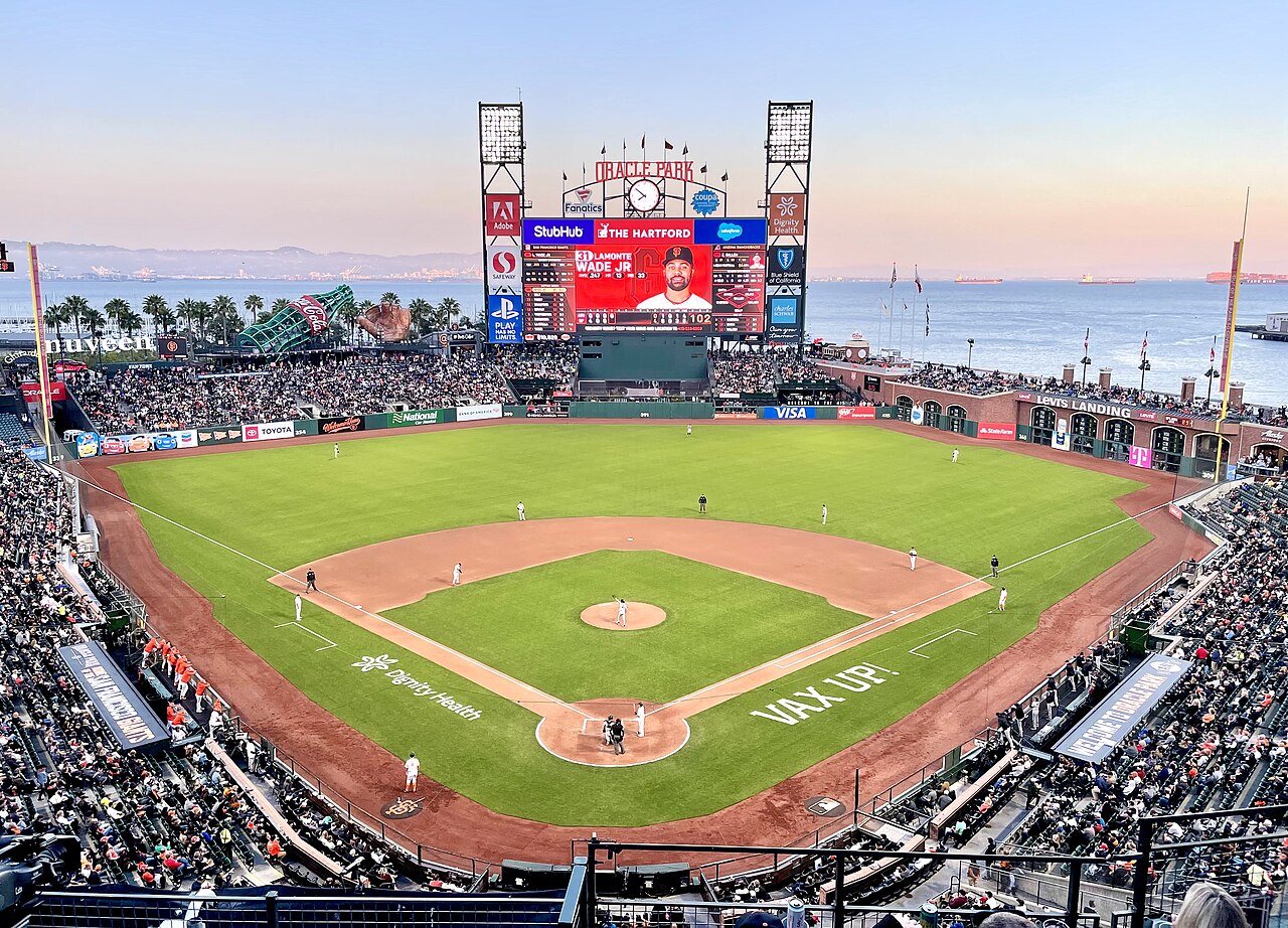
Major League Baseball's San Francisco Giants have played in San Francisco since moving from New York in 1958. The Giants play at Oracle Park, which opened in 2000.[308] The Giants won World Series titles in 2010, 2012, and in 2014. The Giants have boasted stars such as Willie Mays, Willie McCovey, and Barry Bonds (MLB's career home run leader). In 2012, San Francisco was ranked No. 1 in a study that examined which U.S. metro areas have produced the most Major Leaguers since 1920.[309]
The San Francisco 49ers of the National Football League (NFL) began playing in 1946 as an All-America Football Conference (AAFC) league charter member, moved to the NFL in 1950 and into Candlestick Park in 1971. The team left San Francisco in 2014, moving approximately 50 miles south to Santa Clara, and began playing its home games at Levi's Stadium,[310][311] Despite this, the 49ers are still branded as a San Francisco team, and when the team hosted Super Bowl 50 events were hosted in San Francisco such as The annual NFL Experience which was held at the Moscone Center and "Super Bowl City" which opened on January 30 at Justin Herman Plaza on The Embarcadero.[312][313] The 49ers have won five Super Bowl titles between 1982 and 1995.

The NBA's Golden State Warriors have played in the San Francisco Bay Area since moving from Philadelphia in 1962. The Warriors played as the San Francisco Warriors, from 1962 to 1971, before being renamed the Golden State Warriors prior to the 1971–1972 season in an attempt to present the team as a representation of the whole state of California, which had already adopted "The Golden State" nickname.[314] The Warriors' arena, Chase Center, is located in San Francisco.[315] After winning two championships in Philadelphia, they have won five championships since moving to the San Francisco Bay Area,[316] and made five consecutive NBA Finals from 2015 to 2019, winning three of them. They won again in 2022, the franchise's first championship while residing in San Francisco proper.
At the collegiate level, the San Francisco Dons compete in NCAA Division I. Bill Russell led the Dons basketball team to NCAA championships in 1955 and 1956. There is also the San Francisco State Gators, who compete in NCAA Division II.[317] Oracle Park hosted the annual Fight Hunger Bowl college football game from 2002 through 2013 before it moved to Santa Clara.
There are a handful of lower-league soccer clubs in San Francisco playing mostly from April – June.

The Bay to Breakers footrace, held annually since 1912, is best known for colorful costumes and a celebratory community spirit.[318] The San Francisco Marathon attracts more than 21,000 participants.[319] The Escape from Alcatraz triathlon has, since 1980, attracted 2,000 top professional and amateur triathletes for its annual race.[320] The Olympic Club, founded in 1860, is the oldest athletic club in the United States. Its private golf course has hosted the U.S. Open on five occasions. San Francisco hosted the 2013 America's Cup yacht racing competition.[321]
With an ideal climate for outdoor activities, San Francisco has ample resources and opportunities for amateur and participatory sports and recreation. There are more than 200 miles (320 km) of bicycle paths, lanes and bike routes in the city.[322]San Francisco residents have often ranked among the fittest in the country.[323] Golden Gate Park has miles of paved and unpaved running trails as well as a golf course and disc golf course. Boating, sailing, windsurfing and kitesurfing are among the popular activities on San Francisco Bay, and the city maintains a yacht harbor in the Marina District.
San Francisco also has had Esports teams, such as the Overwatch League's San Francisco Shock. Established in 2017,[324] they won two back-to-back championship titles in 2019 and 2020.[325][326]
.jpg/1280px-Aerial_view_of_San_Francisco,_30_Jun_2018_(cropped).jpg)
Several of San Francisco's parks and nearly all of its beaches form part of the regional Golden Gate National Recreation Area, one of the most visited units of the National Park system in the United States with over 13 million visitors a year. Among the GGNRA's attractions within the city are Ocean Beach, which runs along the Pacific Ocean shoreline and is frequented by a vibrant surfing community, and Baker Beach, which is located in a cove west of the Golden Gate Bridge, as well as the California Academy of Sciences, a research institute and natural history museum.
The Presidio of San Francisco is the former 18th century Spanish military base, which today is one of the city's largest parks and home to numerous museums and institutions. Also within the Presidio is Crissy Field, a former airfield that was restored to its natural salt marsh ecosystem. The GGNRA also administers Fort Funston, Lands End, Fort Mason, and Alcatraz. The National Park Service separately administers the San Francisco Maritime National Historical Park – a fleet of historic ships and waterfront property around Aquatic Park.[citation needed]


There are more than 220 parks maintained by the San Francisco Recreation & Parks Department.[328] The largest and best-known city park is Golden Gate Park,[329] which stretches from the center of the city west to the Pacific Ocean. Once covered in native grasses and sand dunes, the park was conceived in the 1860s and was created by the extensive planting of thousands of non-native trees and plants. The large park is rich with cultural and natural attractions such as the Conservatory of Flowers, Japanese Tea Garden and San Francisco Botanical Garden.[citation needed]
Lake Merced is a fresh-water lake surrounded by parkland[citation needed] and near the San Francisco Zoo, a city-owned park that houses more than 250 animal species, many of which are endangered.[330] The only park managed by the California State Park system located principally in San Francisco, Candlestick Point was the state's first urban recreation area.[331]
Most of San Francisco's islands are protected as parkland or nature reserves. Alcatraz Island, operated by the National Park Service, is open to the public. The Farallon Islands are protected wildlife refuges. The Seal Rocks are protected as part of Golden Gate National Recreation Area. Red Rock Island is the only privately owned island in San Francisco Bay, but is uninhabited. Yerba Buena Island is largely utilized by the military.
San Francisco is the first city in the U.S. to have a park within a 10-Minute Walk of every resident.[332][333] It also ranks fifth in the U.S. for park access and quality in the 2018 ParkScore ranking of the top 100 park systems across the United States, according to the nonprofit Trust for Public Land.[334]
_(cropped).jpg/1280px-San_Francisco_City_Hall_(front)_(cropped).jpg)
The mayor is also the county executive, and the county Board of Supervisors acts as the city council. The government of San Francisco is a charter city and is constituted of two co-equal branches: the executive branch is headed by the mayor and includes other citywide elected and appointed officials as well as the civil service; the 11-member Board of Supervisors, the legislative branch, is headed by a president and is responsible for passing laws and budgets, though San Franciscans also make use of direct ballot initiatives to pass legislation.[335]
Because of its unique city-county status, the local government is able to exercise jurisdiction over certain property outside city limits. San Francisco International Airport, though located in San Mateo County, is owned and operated by the City and County of San Francisco. San Francisco's largest jail complex (County Jail No. 5) is located in San Mateo County, in an unincorporated area adjacent to San Bruno. San Francisco was also granted a perpetual leasehold over the Hetch Hetchy Valley and watershed in Yosemite National Park by the Raker Act in 1913.[336]

The members of the Board of Supervisors are elected as representatives of specific districts within the city.[337] Upon the death or resignation of the mayor, the President of the Board of Supervisors becomes acting mayor until the full Board elects an interim replacement for the remainder of the term. In 1978, Dianne Feinstein assumed the office following the assassination of George Moscone and was later selected by the board to finish the term.[citation needed] In 2011, Ed Lee was selected by the board to finish the term of Gavin Newsom, who resigned to take office as Lieutenant Governor of California.[338] Lee (who won two elections to remain mayor) was temporarily replaced by San Francisco Board of Supervisors President London Breed after he died on December 12, 2017. Supervisor Mark Farrell was appointed by the Board of Supervisors to finish Lee's term on January 23, 2018.
Most local offices in San Francisco are elected using ranked choice voting.[339]
.jpg/1280px-San_Francisco_Federal_Building_(main_structure,_seen_from_Mission_and_7th,_2020).jpg)
San Francisco serves as the regional hub for many arms of the federal bureaucracy, including the U.S. Court of Appeals, the Federal Reserve Bank, and the U.S. Mint. Until decommissioning in the early 1990s, the city had major military installations at the Presidio, Treasure Island, and Hunters Point—a legacy still reflected in the annual celebration of Fleet Week. The State of California uses San Francisco as the home of the state supreme court and other state agencies. Foreign governments maintain more than seventy consulates in San Francisco.[340]
The municipal budget for fiscal year 2015–16 was $8.99 billion,[341] and is one of the largest city budgets in the United States.[342] The City of San Francisco spends more per resident than any city other than Washington, D.C., over $10,000 in FY 2015–2016.[342] The city employs around 27,000 workers.[343]
_(cropped).jpg/1280px-U.S._Post_Office_&_Courthouse_(San_Francisco)_(cropped).jpg)
In the California State Senate, San Francisco is in the 11th Senate District, represented by Democrat Scott Wiener. In the California State Assembly, it is split between the 17th Assembly District, represented by Democrat Matt Haney, and the 19th Assembly District, represented by Democrat Phil Ting.[344]
In the United States House of Representatives, San Francisco is split between two congressional districts. Most of the city is in the 11th District, represented by Nancy Pelosi (D–San Francisco). A sliver in the southwest is part of the 15th District represented by Kevin Mullin (D–South San Francisco).[345] Pelosi served as the House Speaker from January 3, 2019, to January 3, 2023, a post she also held from 2007 through 2011. She has also held the post of House Minority Leader, from 2003 to 2007 and 2011 to 2019.
.jpg/1280px-Lone_Mountain_Campus_(cropped).jpg)
The University of California, San Francisco is the sole campus of the University of California system entirely dedicated to graduate education in health and biomedical sciences. It is ranked among the top five medical schools in the United States[346] and operates the UCSF Medical Center, which ranks as the number one hospital in California and the number 5 in the country.[347] UCSF is a major local employer, second in size only to the city and county government.[348][349][350] A 43-acre (17 ha) Mission Bay campus was opened in 2003, complementing its original facility in Parnassus Heights. It contains research space and facilities to foster biotechnology and life sciences entrepreneurship and will double the size of UCSF's research enterprise.[351] All in all, UCSF operates more than 20 facilities across San Francisco.[352]
The University of California College of the Law, San Francisco, founded in Civic Center in 1878, is the oldest law school in California and claims more judges on the state bench than any other institution.[353]San Francisco's two University of California institutions have recently formed an official affiliation in the UCSF/UC Law SF Consortium on Law, Science & Health Policy.[354]

San Francisco State University is part of the California State University system and is located near Lake Merced.[355] The school has approximately 30,000 students and awards undergraduate, master's and doctoral degrees in more than 100 disciplines.[355] The City College of San Francisco, with its main facility in the Ingleside district, is one of the largest two-year community colleges in the country. It has an enrollment of about 100,000 students and offers an extensive continuing education program.[356]
.JPG/1280px-McAllister_Tower_in_San_Francisco_(TK2).JPG)
Founded in 1855, the University of San Francisco, a private Jesuit university located on Lone Mountain, is the oldest institution of higher education in San Francisco and one of the oldest universities established west of the Mississippi River.[357] Golden Gate University is a private, nonsectarian university formed in 1901 and located in the Financial District.
With an enrollment of 13,000 students, the Academy of Art University is the largest institute of art and design in the nation.[358] The California College of the Arts, located north of Potrero Hill, has programs in architecture, fine arts, design, and writing.[359] The San Francisco Conservatory of Music, the only independent music school on the West Coast, grants degrees in orchestral instruments, chamber music, composition, and conducting. The San Francisco Art Institute, founded in 1871 and the oldest art school west of the Mississippi,[360] closed in 2022.
The California Culinary Academy, associated with the Le Cordon Bleu program, offers programs in the culinary arts, baking and pastry arts, and hospitality and restaurant management.California Institute of Integral Studies, founded in 1968, offers a variety of graduate programs in its Schools of Professional Psychology & Health, and Consciousness and Transformation.

Public schools are run by the San Francisco Unified School District, which covers the entire city and county,[361] as well as the California State Board of Education for some charter schools. Lowell High School, the oldest public high school in the U.S. west of the Mississippi,[362] and the smaller School of the Arts High School are two of San Francisco's magnet schools at the secondary level. Public school students attend schools based on an assignment system rather than neighborhood proximity.[363]
Just under 30% of the city's school-age population attends one of San Francisco's more than 100 private or parochial schools, compared to a 10% rate nationwide.[364] Nearly 40 of those schools are Catholic schools managed by the Archdiocese of San Francisco.[365]
San Francisco has nearly 300 preschool programs primarily operated by Head Start, San Francisco Unified School District, private for-profit, private non-profit and family child care providers.[366] All four-year-old children living in San Francisco are offered universal access to preschool through the Preschool for All program.[367]

The major daily newspaper in San Francisco is the San Francisco Chronicle, which is currently Northern California's most widely circulated newspaper.[368] The Chronicle is most famous for a former columnist, the late Herb Caen, whose daily musings attracted critical acclaim and represented the "voice of San Francisco." The San Francisco Examiner, once the cornerstone of William Randolph Hearst's media empire and the home of Ambrose Bierce, declined in circulation over the years and now takes the form of a free daily tabloid, under new ownership.[369][370]
Sing Tao Daily claims to be the largest of several Chinese language dailies that serve the Bay Area.[371] SF Weekly is the city's alternative weekly newspaper. San Francisco and 7x7 are major glossy magazines about San Francisco. The national newsmagazine Mother Jones is also based in San Francisco. San Francisco is home to online-only media publications such as SFist, and AsianWeek.

The San Francisco Bay Area is the sixth-largest television market.[372] It is the fourth-largest radio market after that of New York City, Los Angeles, and Chicago.[373] in the U.S.
All major U.S. television networks have affiliates serving the region, with most of them based in the city. CNN, MSNBC, BBC, Russia Today, and CCTV America also have regional news bureaus in San Francisco. Bloomberg West was launched in 2011 from a studio on the Embarcadero and CNBC broadcasts from One Market Plaza since 2015. ESPN uses the local ABC studio for their broadcasting. The regional sports network, Comcast SportsNet Bay Area and its sister station Comcast SportsNet California, are both located in San Francisco. The Pac-12 Network is also based in San Francisco.

Public broadcasting outlets include both a television station and a radio station, both broadcasting under the call letters KQED from a facility near the Potrero Hill neighborhood. KQED-FM is the most-listened-to National Public Radio affiliate in the country.[374]
KUSF is a student-run radio station by college students from the University of San Francisco.[375] Another local broadcaster, KPOO, is an independent, African-American owned and operated noncommercial radio station established in 1971.[376] CNET, founded 1994, and Salon.com, 1995, are based in San Francisco. Sutro Tower is an important broadcast tower located between Mount Sutro and the Twin Peaks, built in 1973 for KTVU, KRON, and KPIX.

Transit is the most used form of transportation every day in San Francisco. Every weekday, more than 560,000 people travel on Muni's 69 bus routes and more than 140,000 customers ride the Muni Metro light rail system.[377] 32% of San Francisco residents use public transportation for their daily commute to work, ranking it fourth in the United States and first on the West Coast.[378] The San Francisco Municipal Railway, primarily known as Muni, is the primary public transit system of San Francisco. As of 2023, Muni is the eighth-largest transit system in the United States.[379] The system operates a combined light rail and subway system, the Muni Metro, as well as large bus and trolley coach networks.[380] Additionally, it runs a historic streetcar line, which runs on Market Street from Castro Street to Fisherman's Wharf.[380] It also operates the famous cable cars,[380] which have been designated as a National Historic Landmark and are a major tourist attraction.[381]
Bay Area Rapid Transit (BART), a regional Rapid Transit system, connects San Francisco with the East Bay and San Jose through the underwater Transbay Tube. The line, which contains all except the Orange Line, runs under Market Street to Civic Center where it turns south to the Mission District, the southern part of the city, and through northern San Mateo County, to the San Francisco International Airport, and Millbrae.[380]BART also shares stations with SFMTA Muni Metro under Market Street.
.JPG/1280px-L_Taraval_train_on_Ulloa_Street,_June_2017-001_(cropped).JPG)
Another commuter rail system, Caltrain, runs from San Francisco along the San Francisco Peninsula to San Jose.[380] Historically, trains operated by Southern Pacific Lines ran from San Francisco to Los Angeles, via Palo Alto and San Jose.
Amtrak Thruway runs a shuttle bus from three locations in San Francisco to its station across the bay in Emeryville.[382] Additionally, BART offers connections to San Francisco from Amtrak's stations in Emeryville, Oakland and Richmond, and Caltrain offers connections in San Jose and Santa Clara. Thruway service also runs south to San Luis Obispo with connection to the Pacific Surfliner.
San Francisco was an early adopter of carsharing in America. The non-profit City CarShare opened in 2001[383] and Zipcar closely followed.[384]
.jpg/1280px-The_Larkspur_Ferry_%E2%80%9CMendocino%E2%80%9D_at_the_San_Francisco_Ferry_Terminal_in_June_of_2023_(cropped).jpg)
San Francisco Bay Ferry operates from the Ferry Building and Pier 39 to points in Oakland, Alameda, Bay Farm Island, South San Francisco, Richmond, and north to Vallejo in Solano County.[385] The Golden Gate Ferry is the other ferry operator with service between San Francisco and Marin County.[386] SolTrans runs supplemental bus service between the Ferry Building and Vallejo.
To accommodate the large amount of San Francisco citizens who commute to the Silicon Valley daily, employers like Genentech, Google, and Apple have begun to provide private bus transportation for their employees, from San Francisco locations. These buses have quickly become a heated topic of debate within the city, as protesters claim they block bus lanes and delay public buses.[387]

In 2014, only 41.3% of residents commuted by driving alone or carpooling in private vehicles in San Francisco, a decline from 48.6% in 2000.[388] There are 1,088 miles of streets in San Francisco with 946 miles of these streets being surface streets, and 59 miles of freeways.[388] Due to its unique geography, and the freeway revolts of the late 1950s,[389]Interstate 80 begins at the approach to the Bay Bridge and is the only direct automobile link to the East Bay. U.S. Route 101 connects to the western terminus of Interstate 80 and provides access to the south of the city along San Francisco Bay toward Silicon Valley. Northward, the routing for U.S. 101 uses arterial streets to connect to the Golden Gate Bridge, the only direct automobile link to Marin County and the North Bay.
As part of the retrofitting of the Golden Gate Bridge and installation of a suicide barrier, starting in 2019 the railings on the west side of the pedestrian walkway were replaced with thinner, more flexible slats in order to improve the bridge's aerodynamic tolerance of high wind to 100 mph (161 km/h). Starting in June 2020, reports were received of a loud hum produced by the new railing slats, heard across the city when a strong west wind was blowing.[390]

State Route 1 also enters San Francisco from the north via the Golden Gate Bridge and bisects the city as the 19th Avenue arterial thoroughfare, joining with Interstate 280 at the city's southern border. Interstate 280 continues south from San Francisco, and also turns to the east along the southern edge of the city, terminating just south of the Bay Bridge in the South of Market neighborhood. After the 1989 Loma Prieta earthquake, city leaders demolished the Embarcadero Freeway and a portion of the Central Freeway, converting them into street-level boulevards.[389]
State Route 35 enters the city from the south as Skyline Boulevard and terminates at its intersection with Highway 1. State Route 82 enters San Francisco from the south as Mission Street, and terminates shortly thereafter at its junction with 280. The western terminus of the historic transcontinental Lincoln Highway, the first road across America, is in San Francisco's Lincoln Park.
In 2014, San Francisco committed to Vision Zero, with the goal of ending all traffic fatalities caused by motor vehicles within the city by 2024.[391] San Francisco's Vision Zero plan calls for investing in engineering, enforcement, and education, and focusing on dangerous intersections. In 2013, 25 people were killed by car and truck drivers while walking and biking in the city and 9 car drivers and passengers were killed in collisions. In 2019, 42 people were killed in traffic collisions in San Francisco.[392]

Though located 13 miles (21 km) south of downtown in unincorporated San Mateo County, San Francisco International Airport (SFO) is under the jurisdiction of the City and County of San Francisco. SFO is a hub for United Airlines[393] and Alaska Airlines.[394] SFO is a major international gateway to Asia and Europe, with the largest international terminal in North America.[395] In 2011, SFO was the eighth-busiest airport in the U.S. and the 22nd-busiest in the world, handling over 40.9 million passengers.[396]
Located in the South Bay, the San Jose International Airport (SJC) is the second-busiest airport in the Bay Area, followed by San Francisco Bay Oakland International Airport, which is a popular, low-cost alternative to SFO. Geographically, San Francisco Bay Oakland Airport is approximately the same distance from downtown San Francisco as SFO, but due to its location across San Francisco Bay, it is greater driving distance from San Francisco.[citation needed]

Cycling is a popular mode of transportation in San Francisco, with 75,000 residents commuting by bicycle each day.[397] In recent years,[when?] the city has installed better cycling infrastructure such as protected bike lanes and parking racks.[398] Bay Wheels, previously named Bay Area Bike Share at inception, launched in August 2013 with 700 bikes in downtown San Francisco, selected cities in the East Bay, and San Jose. The San Francisco Municipal Transportation Agency and Bay Area Air Quality Management District are responsible for the operation with management provided by Motivate.[399] A major expansion started in 2017, along with a rebranding as Ford GoBike; the company received its current name in 2019.[400]Pedestrian traffic is also widespread. In 2015, Walk Score ranked San Francisco the second-most walkable city in the United States.[401][402][403]
San Francisco has significantly higher rates of pedestrian and bicyclist traffic deaths than the United States on average. In 2013, 21 pedestrians were killed in vehicle collisions, the highest since 2001,[404] which is 2.5 deaths per 100,000 population – 70% higher than the national average of 1.5.[405]
.jpg/1280px-Critical_Mass,_San_Francisco,_April_29,_2005_(cropped).jpg)
Cycling is becoming increasingly popular in the city. The 2010 Municipal Transportation Agency (MTA) annual bicycle count showed the number of cyclists at 33 locations had increased 58% from the 2006 baseline counts.[406] In 2008, the MTA estimated that about 128,000 trips were made by bicycle each day in the city, or 6% of total trips.[407] As of 2019[update], 2.6% of the city's streets have protected bike lanes, with 28 miles of protected bike lanes in the city.[377] Since 2006, San Francisco has received a Bicycle Friendly Community status of "Gold" from the League of American Bicyclists.[408] In 2022 a measure on the ballot passed to protect JFK drive in Golden Gate Park as a pedestrian and biking space with 59% of voters in favor.[409]
The San Francisco Police Department was founded in 1849.[410] The portions of the Golden Gate National Recreation Area located within the city, including the Presidio and Ocean Beach, are patrolled by the United States Park Police.
The San Francisco Fire Department provides both fire suppression and emergency medical services to the city.[411]
San Francisco participates in the Sister Cities program.[412] A total of 41 consulates general and 23 honorary consulates have offices in the San Francisco Bay Area.[413]
In January 1980, Mayor Dianne Feinstein signed a sister cities agreement with Shanghai during a visit to China.[414]
San Francisco was incorporated as a City on April 15th, 1850 by act of the Legislature.
The final, insurmountable decline in San Francisco's shipping activity was heralded in 1958 by the departure of the first containerized freighter from San Francisco Bay.
During the 1960s and 1970s San Francisco's historic maritime industry relocated to Oakland. ... San Francisco remained a center for business and professional services (such as consulting, law, accounting and finance) and also successfully developed its tourism sector, which became the leading local industry.
The findings support what many social workers have long suspected – that there was a "big bang" homeless population explosion as federal housing programs were slashed and the closing of mental hospitals hit home in the mid-1980s and that this core group constitutes the bulk of the street population.
Another positive trend for the future is San Francisco's highly entrepreneurial, flexible and innovative economy...San Francisco's very high reliance on small business and self-employment is typical of other dynamic, fast-growing, high-technology areas across the country.
What it's like to live in a city that no longer believes its problems can be fixed.
{{cite web}}: |last= has generic name (help){{cite news}}: CS1 maint: url-status (link)On any given week in San Francisco, office buildings are at about 40 percent of their prepandemic occupancy.
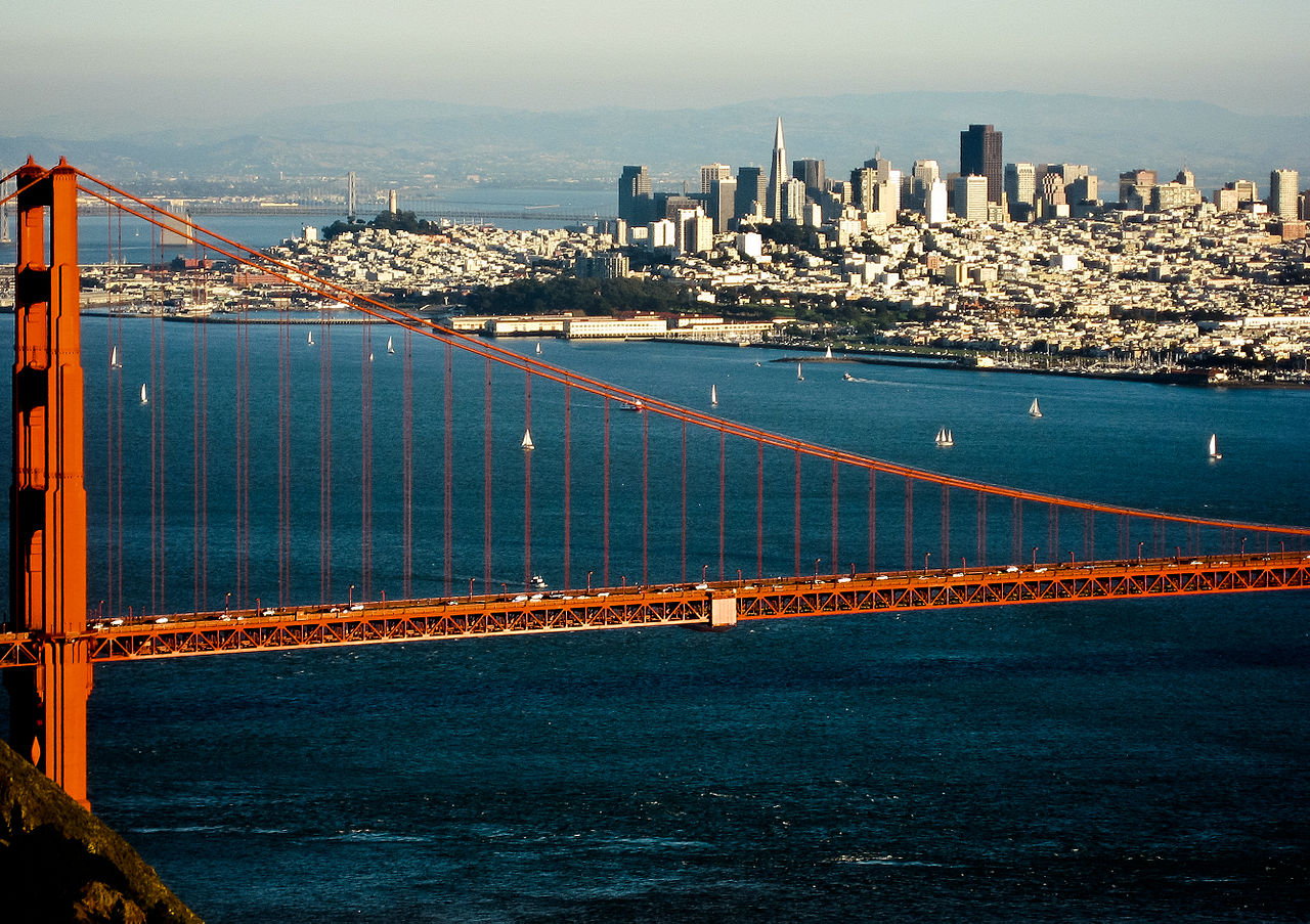