


La Era de los Descubrimientos , también conocida como la Era de la Exploración , fue parte del período moderno temprano y se superpuso en gran medida con la Era de la Navegación . Fue un período desde aproximadamente fines del siglo XV hasta el siglo XVII , durante el cual los navegantes de varios países europeos exploraron, colonizaron y conquistaron regiones en todo el mundo. La Era de los Descubrimientos fue un período transformador en la historia mundial cuando partes del mundo previamente aisladas se conectaron para formar el sistema mundial y sentaron las bases para la globalización . La extensa exploración en ultramar, en particular la apertura de rutas marítimas a las Indias y la colonización europea de las Américas por parte de españoles y portugueses , a los que luego se unieron ingleses , franceses y holandeses , impulsaron el comercio global internacional . La economía global interconectada del siglo XXI tiene su origen en la expansión de las redes comerciales durante esta era.
La exploración también creó imperios coloniales y marcó una mayor adopción del colonialismo como política gubernamental en varios estados europeos. Como tal, a veces se la considera sinónimo de la primera ola de colonización europea . La colonización reformuló la dinámica del poder, lo que provocó cambios geopolíticos en Europa y creó nuevos centros de poder más allá de Europa. Después de haber marcado la historia humana en el curso común global, el legado de la Era todavía da forma al mundo actual.
La exploración oceánica europea comenzó con las expediciones marítimas de Portugal a las Islas Canarias en 1336, [1] [2] y más tarde con los descubrimientos portugueses de los archipiélagos atlánticos de Madeira y Azores , la costa de África occidental en 1434, y el establecimiento de la ruta marítima a la India en 1498 por Vasco da Gama , que inició la presencia marítima y comercial portuguesa en Kerala y el Océano Índico . [3] [4]
Durante la Era de los Descubrimientos, España patrocinó y financió los viajes transatlánticos del navegante italiano Cristóbal Colón , que de 1492 a 1504 marcaron el inicio de la colonización en América, y la expedición del explorador portugués Fernando de Magallanes para abrir una ruta desde el océano Atlántico hasta el Pacífico, que luego logró la primera circunnavegación del globo entre 1519 y 1522. Estas expediciones españolas impactaron significativamente las percepciones europeas del mundo. Estos descubrimientos dieron lugar a numerosas expediciones navales a través de los océanos Atlántico , Índico y Pacífico , y expediciones terrestres en América, Asia , África y Australia que continuaron hasta fines del siglo XIX, seguidas por la exploración de las regiones polares en el siglo XX.
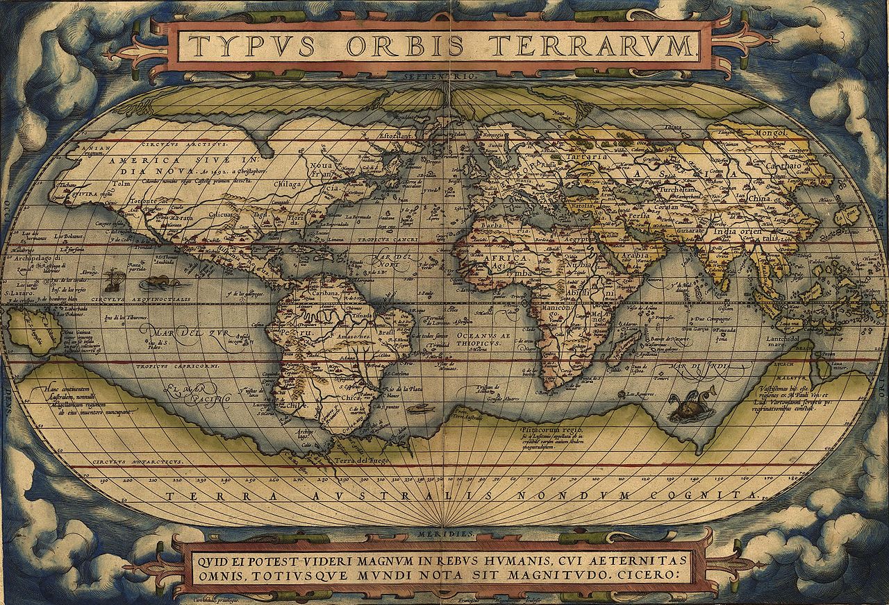
La exploración europea inició el intercambio colombino entre el Viejo Mundo (Europa, Asia y África) y el Nuevo Mundo (América y Australia). Este intercambio implicó la transferencia de plantas, animales, poblaciones humanas (incluidos esclavos ), enfermedades contagiosas y cultura a través de los hemisferios oriental y occidental . La Era de los Descubrimientos y la exploración europea implicaron la cartografía del mundo , dando forma a una nueva visión del mundo y facilitando el contacto con civilizaciones distantes. Los continentes dibujados por los cartógrafos europeos de la época evolucionaron a partir de "manchas" abstractas en los contornos más reconocibles para nosotros hoy. [5] Simultáneamente, la propagación de nuevas enfermedades, especialmente las que afectaban a los indios americanos , condujo a una rápida disminución de la población . La era vio una esclavitud generalizada , la explotación y la conquista militar de las poblaciones nativas , al mismo tiempo que la creciente influencia económica y la difusión de la cultura , la ciencia y la tecnología occidentales y europeas , lo que llevó a un crecimiento demográfico más rápido que exponencial en todo el mundo.
El concepto de descubrimiento ha sido analizado, destacando críticamente la historia del término central de esta periodización . [6] El término "era del descubrimiento" se encuentra en la literatura histórica y todavía se usa comúnmente. J. H. Parry , llamando al período la Era del Reconocimiento , sostiene que no solo fue la era de las exploraciones europeas, sino que también produjo la expansión del conocimiento geográfico y la ciencia empírica . "También vio las primeras victorias importantes de la investigación empírica sobre la autoridad, los comienzos de esa estrecha asociación de ciencia, tecnología y trabajo cotidiano que es una característica esencial del mundo occidental moderno". [7] Anthony Pagden se basa en el trabajo de Edmundo O'Gorman para la afirmación de que "Para todos los europeos, los eventos de octubre de 1492 constituyeron un 'descubrimiento'. Algo de lo que no tenían conocimiento previo se había presentado de repente ante sus ojos". [8] O'Gorman sostiene que el encuentro físico con nuevos territorios fue menos importante que el esfuerzo de los europeos por integrar este nuevo conocimiento en su cosmovisión, lo que él llama "la invención de América". [9] Pagden examina los orígenes de los términos "descubrimiento" e "invención". En inglés, "descubrimiento" y sus formas en las lenguas romances derivan de " disco-operio" , que significa descubrir, revelar, exponer a la mirada", lo que fue revelado existía previamente. [10] Pocos europeos durante el período utilizaron el término "invención" para los encuentros europeos, con la excepción de Martin Waldseemüller , cuyo mapa utilizó por primera vez el término " América ". [11]
Un concepto jurídico central de la doctrina del descubrimiento , expuesta por la Corte Suprema de los Estados Unidos en 1823, se basa en afirmaciones sobre el derecho de las potencias europeas a reclamar tierras durante sus exploraciones. El concepto de "descubrimiento" se ha utilizado para hacer cumplir las reclamaciones coloniales y el descubrimiento, pero ha sido cuestionado por los pueblos indígenas [12] y los investigadores. [13] Muchos pueblos indígenas han cuestionado fundamentalmente el concepto de reivindicación colonial de "descubrimiento" sobre sus tierras y su gente, por considerarlo una presencia indígena forzada y negadora.
El período, llamado alternativamente la Era de la Exploración , ha sido examinado a través de reflexiones sobre la exploración . Su comprensión y uso, se ha discutido como enmarcado y utilizado para aventuras coloniales, discriminación y explotación , al combinarlo con conceptos como la " frontera " (como en la Tesis de la Frontera ) y el destino manifiesto , [14] hasta la era contemporánea de la exploración espacial . [15] [16] [17] [18] Alternativamente, el término contacto , como en primer contacto , se ha utilizado para arrojar más luz sobre la era del descubrimiento y el colonialismo, utilizando los nombres alternativos de Era del Contacto [19] o Periodo de Contacto , [20] discutiéndolo como un "proyecto inacabado, diverso". [21] [22]
Los portugueses comenzaron a explorar sistemáticamente la costa atlántica de África en 1418, bajo el patrocinio del príncipe Enrique el Navegante . En 1488, Bartolomeu Dias llegó al océano Índico por esta ruta. [23]
En 1492, los Reyes Católicos de España financiaron el plan del navegante genovés Cristóbal Colón ( en italiano : Cristoforo Colombo ) de navegar hacia el oeste para llegar a las Indias , cruzando el Atlántico. Colón se encontró con un continente no cartografiado por los europeos (aunque había sido explorado y colonizado temporalmente por los nórdicos 500 años antes). [24] Más tarde, se llamó América en honor a Américo Vespucio , un comerciante que trabajaba para Portugal . [25] [26] Portugal reclamó rápidamente esas tierras bajo los términos del Tratado de Alcáçovas , pero Castilla pudo persuadir al Papa, que era castellano, para que emitiera cuatro bulas papales para dividir el mundo en dos regiones de exploración, donde cada reino tenía derechos exclusivos para reclamar tierras recién descubiertas. Estos fueron modificados por el Tratado de Tordesillas , ratificado por el Papa Julio II . [27] [28]

En 1498, una expedición portuguesa comandada por Vasco da Gama llegó a la India navegando alrededor de África, abriendo el comercio directo con Asia. [29] Mientras que otras flotas exploratorias fueron enviadas desde Portugal al norte de América del Norte, las Armadas de la India portuguesas también extendieron esta ruta oceánica oriental, tocando América del Sur y abriendo un circuito desde el Nuevo Mundo hasta Asia (iniciada en 1500 por Pedro Álvares Cabral ), y exploraron islas en el Atlántico Sur y el Océano Índico Sur. Los portugueses navegaron más al este, a las valiosas Islas de las Especias en 1512, desembarcando en China un año después. Los portugueses llegaron a Japón en 1543. En 1513, el español Vasco Núñez de Balboa cruzó el istmo de Panamá y llegó al "otro mar" desde el Nuevo Mundo. Así, Europa recibió por primera vez noticias del Pacífico oriental y occidental en un lapso de un año alrededor de 1512. La exploración del este y el oeste se superpuso en 1522, cuando una expedición española que navegaba hacia el oeste, liderada por el navegante portugués Fernando de Magallanes y, después de su muerte, por el navegante Juan Sebastián Elcano , completó la primera circunnavegación del mundo. [30] Los conquistadores españoles exploraron el interior de las Américas y algunas de las islas del Pacífico Sur. Su principal objetivo era interrumpir el comercio portugués en Oriente.
A partir de 1495, los franceses, ingleses y holandeses se lanzaron a la carrera de la exploración, tras conocer las hazañas de Colón, desafiando el monopolio ibérico del comercio marítimo buscando nuevas rutas. La primera expedición fue la de John Cabot en 1497 hacia el norte, al servicio de Inglaterra, seguida de expediciones francesas a Sudamérica y, más tarde, a Norteamérica. Expediciones posteriores se dirigieron al océano Pacífico, rodeando Sudamérica, y finalmente, siguiendo a los portugueses por África, hasta el océano Índico, descubriendo Australia en 1606, Nueva Zelanda en 1642 y Hawai en 1778. Desde la década de 1580 hasta la de 1640, los rusos exploraron y conquistaron casi toda Siberia y Alaska en la década de 1730.
Después de que la caída del Imperio Romano de Occidente cortara en gran medida la conexión entre Europa y las tierras más al este, la Europa cristiana quedó en gran medida atrasada en comparación con el mundo árabe, que conquistó e incorporó grandes territorios en Oriente Medio y el norte de África. Las cruzadas cristianas para recuperar Tierra Santa , de manos de los musulmanes, no fueron un éxito militar, pero sí pusieron a Europa en contacto con Oriente Medio y los valiosos bienes que allí se fabricaban o comercializaban. A partir del siglo XII, la economía europea se transformó gracias a la interconexión de las rutas comerciales fluviales y marítimas. [31] : 345
Antes del siglo XII, un obstáculo para el comercio al este del estrecho de Gibraltar , que dividía el Mediterráneo del océano Atlántico, era el control musulmán del territorio, incluida la península Ibérica y los monopolios comerciales de las ciudades-estado cristianas en la península italiana, especialmente Venecia y Génova . El crecimiento económico de Iberia siguió a la reconquista cristiana de Al-Ándalus en lo que hoy es el sur de España y al asedio de Lisboa (1147 d. C.), en Portugal. El declive de la fuerza naval del califato fatimí , que comenzó antes de la Primera Cruzada , ayudó a los estados marítimos italianos, principalmente Venecia, Génova y Pisa, a dominar el comercio en el Mediterráneo oriental , con comerciantes allí volviéndose ricos y políticamente influyentes. Otro cambio en la situación mercantil en el Mediterráneo oriental fue la disminución del poder naval bizantino cristiano tras la muerte del emperador Manuel I Comneno en 1180, cuya dinastía había hecho notables tratados y concesiones con los comerciantes italianos, permitiendo el uso de los puertos cristianos bizantinos. La conquista normanda de Inglaterra, a finales del siglo XI, permitió el comercio pacífico en el Mar del Norte . La Liga Hanseática , una confederación de gremios de comerciantes y sus ciudades en el norte de Alemania, a lo largo del Mar del Norte y el Mar Báltico, fue fundamental en el desarrollo comercial de la región. En el siglo XII, las regiones de Flandes , Henao y Brabante produjeron los textiles de mejor calidad del noroeste de Europa, lo que animó a los comerciantes de Génova y Venecia a navegar hasta allí desde el Mediterráneo, a través del estrecho de Gibraltar y hasta la costa atlántica. [31] : 316–38 Nicolòzzo Spinola realizó el primer viaje directo registrado desde Génova a Flandes en 1277. [31] : 328
Los avances tecnológicos que fueron importantes para la Era de la Exploración fueron la adopción de la brújula magnética y los avances en el diseño de barcos.
La brújula fue una adición al antiguo método de navegación basado en la observación del sol y las estrellas. Fue inventada durante la dinastía Han china y se había utilizado para la navegación en China en el siglo XI. Fue adoptada por los comerciantes árabes en el océano Índico. La brújula se extendió a Europa a fines del siglo XII o principios del siglo XIII. [32] El uso de la brújula para la navegación en el océano Índico se mencionó por primera vez en 1232. [31] : 351–2 La primera mención del uso de la brújula en Europa fue en 1180. [31] : 382 Los europeos usaban una brújula "seca", con una aguja en un pivote. La tarjeta de la brújula también fue una invención europea. [31]
Los barcos aumentaron de tamaño, requerían tripulaciones más pequeñas y podían navegar distancias más largas sin detenerse. Esto condujo a costos de envío de larga distancia significativamente más bajos en el siglo XIV. [31] : 342 Los barcos de pesca siguieron siendo populares para el comercio debido a su bajo costo. Las galeras también se usaban en el comercio. [31]

El Periplo del mar Eritreo , un documento del 40-60 d. C., describe una ruta recién descubierta a través del mar Rojo hasta la India, con descripciones de los mercados en las ciudades alrededor del mar Rojo, el golfo Pérsico y el océano Índico, incluso a lo largo de la costa este de África, que afirma que "más allá de estos lugares, el océano inexplorado se curva hacia el oeste y, al correr por las regiones al sur de Etiopía, Libia y África, se mezcla con el mar occidental (posible referencia al océano Atlántico)". El conocimiento medieval europeo sobre Asia más allá del alcance del Imperio bizantino se obtuvo de informes parciales, a menudo oscurecidos por leyendas, [33] que datan de las conquistas de Alejandro Magno y sus sucesores. Otra fuente fueron las redes comerciales judías radhanitas de comerciantes establecidas como intermediarios entre Europa y el mundo musulmán durante la época de los estados cruzados .

En 1154, el geógrafo árabe Muhammad al-Idrisi creó una descripción del mundo y un mapa del mundo , la Tabula Rogeriana , en la corte del rey Roger II de Sicilia , [34] [35] pero todavía África era solo parcialmente conocida por los cristianos, genoveses y venecianos, o los marineros árabes, y su extensión al sur era desconocida. Había informes del gran Sahara africano , pero el conocimiento estaba limitado para los europeos, a la costa mediterránea y poco más, ya que el bloqueo árabe del norte de África impedía la exploración del interior. El conocimiento sobre la costa atlántica africana estaba fragmentado y derivaba principalmente de antiguos mapas griegos y romanos basados en el conocimiento cartaginés, incluida la exploración romana de Mauritania . El Mar Rojo apenas se conocía y solo los vínculos comerciales con las repúblicas marítimas , especialmente Venecia, fomentaron la recopilación de conocimientos marítimos precisos. [36] Las rutas comerciales del Océano Índico fueron navegadas por comerciantes árabes.
En 1400, una traducción latina de la Geographia de Ptolomeo llegó a Italia desde Constantinopla. El redescubrimiento del conocimiento geográfico romano fue una revelación, [37] tanto para la cartografía como para la cosmovisión, [38] aunque reforzó la idea de que el océano Índico no tenía salida al mar.


Un preludio a la Era de los Descubrimientos fue una serie de expediciones europeas que cruzaron Eurasia por tierra a finales de la Edad Media. [39] Los mongoles habían amenazado a Europa, pero los estados mongoles también unificaron gran parte de Eurasia y, a partir de 1206, la Pax Mongolica permitió rutas comerciales seguras y líneas de comunicación desde Oriente Medio hasta China. [40] [41] Los estrechos vínculos italianos con el Levante despertaron la curiosidad y el interés comercial en los países que se encontraban más al este. [42] [ página necesaria ] Hay algunos relatos de comerciantes del norte de África y el Mediterráneo, que comerciaban en el Océano Índico a finales de la época medieval. [31]
Durante las invasiones mongolas del Levante , se enviaron embajadas cristianas hasta Karakorum , donde obtuvieron una mayor comprensión del mundo. [43] [44] El primero de estos viajeros fue Giovanni da Pian del Carpine , enviado por el papa Inocencio IV al Gran Khan , que viajó a Mongolia y regresó entre 1241 y 1247. [40] El príncipe ruso Yaroslav de Vladimir y sus hijos Alexander Nevsky y Andrey II de Vladimir viajaron a la capital de Mongolia. Aunque tuvieron fuertes implicaciones políticas, sus viajes no dejaron relatos detallados. Otros viajeros los siguieron, como el francés André de Longjumeau y el flamenco Guillermo de Rubruck , que llegaron a China a través de Asia Central. [45] Marco Polo , un comerciante veneciano, dictó un relato de viajes por toda Asia desde 1271 hasta 1295, describiendo haber sido invitado a la corte de la dinastía Yuan de Kublai Khan en Viajes . Fue leído en toda Europa. [46]
La flota musulmana que custodiaba el estrecho de Gibraltar fue derrotada por Génova en 1291. [47] En ese año, los genoveses intentaron su primera exploración atlántica cuando los hermanos comerciantes Vadino y Ugolino Vivaldi zarparon de Génova con dos galeras, pero desaparecieron frente a la costa marroquí, alimentando los temores de los viajes oceánicos. [48] [49] De 1325 a 1354, un erudito marroquí de Tánger , Ibn Battuta , viajó por el norte de África, el desierto del Sahara, África occidental, el sur de Europa, Europa oriental, el Cuerno de África, Oriente Medio y Asia, habiendo llegado a China. Después de regresar, dictó un relato a un erudito que conoció en Granada, The Rihla ("El viaje"), [50] la fuente no anunciada sobre sus aventuras. [51] Entre 1357 y 1371, un libro de supuestos viajes compilado por John Mandeville adquirió popularidad. A pesar de la naturaleza poco fiable y a menudo fantástica de sus relatos, se utilizó como referencia [52] para Oriente, Egipto y el Levante en general, afirmando la antigua creencia de que Jerusalén era el centro del mundo . Tras el período de relaciones timúridas con Europa , en 1439, Niccolò de' Conti publicó un relato de sus viajes como comerciante musulmán a la India y el sudeste asiático. En 1466-1472, el comerciante ruso Afanasy Nikitin de Tver viajó a la India, que describió en su libro Un viaje más allá de los tres mares .
Estos viajes por tierra tuvieron poco efecto inmediato. El Imperio mongol se derrumbó casi tan rápido como se formó y pronto la ruta hacia el este se volvió más difícil y peligrosa. La peste negra del siglo XIV también bloqueó los viajes y el comercio durante un tiempo. [53]
La religión desempeñó un papel fundamental en la motivación del expansionismo europeo . En 1487, los enviados portugueses Pero da Covilhã y Afonso de Paiva fueron enviados en una misión encubierta para reunir información sobre una posible ruta marítima a la India e indagar sobre el Preste Juan , un patriarca y rey nestoriano , que se creía que gobernaba partes del subcontinente. Covilhã fue recibido calurosamente a su llegada a Etiopía, pero se le prohibió salir. [54]

Durante la Edad Media, la expansión del cristianismo por toda Europa alimentó el deseo de predicar en tierras lejanas. Este esfuerzo evangélico se convirtió en una parte importante de las conquistas militares de las potencias europeas, como Portugal , España y Francia , que a menudo condujeron a la conversión de pueblos indígenas, voluntaria o forzada. [55] [56]
Las órdenes religiosas, como los franciscanos , los dominicos , los agustinos y los jesuitas , participaron en la mayoría de las iniciativas misioneras en el Nuevo Mundo . A finales del siglo XVI y durante el siglo XVII, la presencia de estos últimos aumentó en su intento de reafirmar su poder y revivir la cultura católica de Europa, que había sido dañada por la Reforma . [57]

Los chinos tenían amplias conexiones a través del comercio en Asia y habían estado navegando hacia Arabia , África Oriental y Egipto desde la dinastía Tang (618-907 d. C.). Entre 1405 y 1421, el tercer emperador Ming, Yongle, patrocinó misiones tributarias de largo alcance en el océano Índico bajo el mando del almirante Zheng He . [58] Estos viajes no resultaron en vínculos permanentes con territorios de ultramar, debido a cambios en la política aislacionista, que pusieron fin a los viajes y al conocimiento de ellos.
Se preparó una gran flota de nuevos barcos basura para las expediciones diplomáticas internacionales. El más grande de estos juncos, que los chinos denominaban bao chuan (barcos del tesoro) , puede haber medido 121 metros, y participaron miles de marineros. La primera expedición partió en 1405. Se lanzaron al menos siete expediciones bien documentadas, cada una más grande y más cara que la anterior. Las flotas visitaron Arabia , África Oriental , India , el archipiélago malayo y Tailandia (entonces llamada Siam ), intercambiando bienes en el camino. [59] Presentaron regalos de oro, plata, porcelana y seda ; a cambio, recibieron novedades como avestruces , cebras , camellos , marfil y jirafas . [60] [61] Después de la muerte del emperador, Zheng He dirigió una expedición final que partió de Nanking en 1431 y regresó a Beijing en 1433. Es probable que esta última expedición llegara hasta Madagascar . Los viajes fueron relatados por Ma Huan , un viajero y traductor musulmán que acompañó a Zheng He en tres de las expediciones; su relato se publicó como Yingya Shenglan (Estudio general de las costas del océano) (1433). [62]
Los viajes tuvieron un efecto significativo y duradero en la organización de una red marítima , utilizando y creando nodos y conductos a su paso, reestructurando así las relaciones e intercambios internacionales y transculturales. [63] Fue especialmente impactante ya que ninguna otra entidad política había ejercido dominio naval sobre todos los sectores del Océano Índico, antes de estos viajes. [64] Los Ming promovieron nodos alternativos como una estrategia para establecer el control sobre la red. [65] Por ejemplo, debido a la participación china, puertos como Malaca (en el sudeste asiático), Cochin (costa de Malabar) y Malindi (costa de Swahili) habían crecido como alternativas clave a otros puertos establecidos. [a] [66] La aparición de la flota del tesoro Ming generó e intensificó la competencia entre las entidades políticas contendientes y rivales, cada una buscando una alianza con los Ming. [63]
Los viajes propiciaron la integración regional del océano occidental y aumentaron la circulación internacional de personas, ideas y bienes. Proporcionó una plataforma para los discursos cosmopolitas , que tuvieron lugar en lugares como los barcos de la flota del tesoro Ming, las capitales Ming de Nanjing y Pekín, y las recepciones de banquetes organizadas por la corte Ming para los representantes extranjeros. [63] Diversos grupos de personas de países marítimos se congregaron, interactuaron y viajaron juntos mientras la flota del tesoro navegaba desde y hacia China. [63] Por primera vez, la región marítima desde China hasta África estaba bajo el dominio de una sola potencia imperial y permitió la creación de un espacio cosmopolita. [67]
Estos viajes de larga distancia no tuvieron continuidad, ya que la dinastía Ming se replegó en el haijin , una política de aislacionismo , habiendo limitado el comercio marítimo. Los viajes se detuvieron abruptamente después de la muerte del emperador, ya que los chinos perdieron interés en lo que denominaban tierras bárbaras, volviéndose hacia el interior, [68] y los emperadores sucesores sintieron que las expediciones eran perjudiciales para el estado chino; el emperador Hongxi puso fin a las expediciones posteriores y el emperador Xuande suprimió gran parte de la información sobre los viajes de Zheng He.

Desde el siglo VIII hasta el siglo XV, la República de Venecia y las repúblicas marítimas vecinas mantuvieron el monopolio del comercio europeo con Oriente Medio. El comercio de la seda y las especias , que incluía especias, incienso , hierbas, drogas y opio , enriqueció fenomenalmente a estas ciudades-estado mediterráneas. Las especias se encontraban entre los productos más caros y demandados de la Edad Media, ya que se utilizaban en la medicina medieval , [69] los rituales religiosos, los cosméticos, la perfumería, así como los aditivos y conservantes alimentarios. [70] Todas ellas se importaban de Asia y África.
Los comerciantes musulmanes dominaban las rutas marítimas en todo el océano Índico, aprovechando las regiones de origen en el Lejano Oriente y enviando mercancías a los emporios comerciales de la India, principalmente Kozhikode , hacia el oeste hasta Ormus en el golfo Pérsico y Jeddah en el mar Rojo . Desde allí, las rutas terrestres conducían a las costas mediterráneas. Los comerciantes venecianos distribuían las mercancías por toda Europa hasta el surgimiento del Imperio otomano , que finalmente condujo a la caída de Constantinopla en 1453, lo que impidió a los europeos algunas importantes rutas combinadas de tierra y mar en áreas alrededor del Egeo, el Bósforo y el mar Negro. [ cita requerida ] Los venecianos y otras repúblicas marítimas mantuvieron un acceso más limitado a las mercancías asiáticas, a través del comercio del sudeste del Mediterráneo, en puertos como Antioquía, Acre y Alejandría.
Obligados a reducir sus actividades en el Mar Negro y en guerra con Venecia, los genoveses se habían volcado al comercio norteafricano de trigo, aceite de oliva y a la búsqueda de plata y oro. Los europeos tenían un déficit constante de plata y oro , [71] ya que solo salían, gastados en el comercio oriental ahora cortado. Varias minas europeas se agotaron, [72] la falta de lingotes condujo al desarrollo de un complejo sistema bancario para gestionar los riesgos en el comercio (el primer banco estatal, el Banco di San Giorgio , fue fundado en 1407 en Génova). Navegando también hacia los puertos de Brujas (Flandes) e Inglaterra, las comunidades genovesas se establecieron entonces en Portugal, [73] que se beneficiaron de su espíritu emprendedor y su experiencia financiera.
La navegación europea se había basado principalmente en el cabotaje terrestre , guiado por cartas portulanas . Estas cartas especificaban rutas oceánicas comprobadas guiadas por puntos de referencia costeros: los navegantes partían de un punto conocido, seguían el rumbo de una brújula e intentaban identificar su ubicación por sus puntos de referencia. [74] Para la primera exploración oceánica, los europeos occidentales utilizaron la brújula, así como los nuevos avances progresivos en cartografía y astronomía. Las herramientas de navegación árabes, como el astrolabio y el cuadrante, se utilizaron para la navegación celestial .
Las tierras musulmanas en Asia estaban generalmente más desarrolladas económicamente y tenían mejor infraestructura que Europa en ese momento, a pesar de los cambios económicos de Europa provocados por la Peste Negra que permitieron más libertades para la gente de clase baja y alta. [75] Los imperios de la pólvora ocultaron el conocimiento a los comerciantes cristianos europeos sobre dónde se encontraban lugares lucrativos como Indonesia , lo que estimuló un mayor deseo de comercio cristiano con otras naciones musulmanas además de los imperios de la pólvora a pesar de que los cristianos europeos generalmente tenían antipatía hacia los musulmanes. [75]

En 1297, el rey Dionisio de Portugal se interesó personalmente en las exportaciones. En 1317, hizo un acuerdo con el marino mercante genovés Manuel Pessanha , nombrándolo primer almirante de la Armada portuguesa , para defender el país contra las incursiones piratas musulmanas. [76] Los brotes de peste bubónica llevaron a una grave despoblación en la segunda mitad del siglo XIV: solo el mar ofrecía alternativas, y la mayoría de la población se instaló en áreas costeras de pesca y comercio. [77] Entre 1325 y 1357, Alfonso IV de Portugal fomentó el comercio marítimo y ordenó las primeras exploraciones. [78] Las Islas Canarias , ya conocidas por los genoveses, fueron reclamadas como oficialmente descubiertas bajo el patrocinio de los portugueses, pero en 1344 Castilla las disputó, expandiendo su rivalidad al mar. [79] [80]
Para asegurar su monopolio del comercio, los europeos (empezando por los portugueses) intentaron instalar un sistema de comercio mediterráneo que utilizaba el poder militar y la intimidación para desviar el comercio a través de los puertos que controlaban; allí podría ser gravado. [81] En 1415, Ceuta fue conquistada por los portugueses con el objetivo de controlar la navegación de la costa africana. El joven príncipe Enrique el Navegante estaba allí y se dio cuenta de las posibilidades de lucro en las rutas comerciales transaharianas . Durante siglos, las rutas de comercio de esclavos y oro que unían África occidental con el Mediterráneo pasaban por el desierto del Sahara occidental, controlado por los moros del norte de África.
Enrique deseaba saber hasta dónde se extendían los territorios musulmanes en África, con la esperanza de evitarlos y comerciar directamente con África occidental por mar, encontrar aliados en las legendarias tierras cristianas del sur [82] como el supuesto reino cristiano perdido hace mucho tiempo del Preste Juan [83] y sondear si era posible llegar a las Indias por mar, la fuente del lucrativo comercio de especias . Invirtió en patrocinar viajes por la costa de Mauritania , reuniendo a un grupo de comerciantes, armadores y partes interesadas en nuevas rutas marítimas. Pronto se llegaron a las islas atlánticas de Madeira (1419) y las Azores (1427). El líder de la expedición que estableció asentamientos en Madeira fue el explorador portugués João Gonçalves Zarco . [84]
Los europeos no sabían qué había más allá del cabo Non ( cabo Chaunar ) en la costa africana, y si era posible regresar una vez cruzado. [85] Los mitos náuticos advertían de monstruos oceánicos o de un fin del mundo, pero la navegación de Enrique desafió tales creencias: a partir de 1421, la navegación sistemática lo superó, llegando al difícil cabo Bojador que en 1434 uno de los capitanes de Enrique, Gil Eanes , finalmente pasó.
A partir de 1440, las carabelas se utilizaron ampliamente para la exploración de la costa de África. Se trataba de un tipo de barco ibérico existente, utilizado para la pesca, el comercio y con fines militares. A diferencia de otras embarcaciones de la época, la carabela tenía un timón montado en la popa (a diferencia de un remo de dirección montado en el lateral). Tenía un calado poco profundo, lo que era útil para explorar costas desconocidas. Tenía un buen rendimiento de navegación, con una capacidad de ceñida que era notable para los estándares de la época. [b] El aparejo latino era menos útil cuando se navegaba a favor del viento, lo que explica que Cristóbal Colón ( en italiano : Cristoforo Colombo ) cambiara el aparejo de la Niña por uno cuadrado . [87]
Para la navegación astronómica, los portugueses utilizaban las efemérides , que experimentaron una notable difusión en el siglo XV. Se trataba de cartas astronómicas que trazaban la ubicación de las estrellas durante un período de tiempo determinado. Publicado en 1496 por el astrónomo, astrólogo y matemático judío Abraham Zacuto , el Almanaque Perpetuum incluía algunas de estas tablas para los movimientos de las estrellas. [88] Estas tablas revolucionaron la navegación, permitiendo el cálculo de la latitud . La longitud exacta siguió siendo esquiva para los navegantes durante siglos. [89] [90] Utilizando la carabela, la exploración sistemática continuó cada vez más al sur, avanzando en promedio un grado al año. [91] Se llegó a Senegal y la península de Cabo Verde en 1445 y en 1446, Álvaro Fernandes avanzó casi hasta la actual Sierra Leona .
En 1453, la caída de Constantinopla ante los otomanos fue un golpe percibido para la cristiandad y estableció vínculos comerciales con Oriente. En 1455, el papa Nicolás V emitió la bula Romanus Pontifex reforzando la anterior Dum Diversas (1452), otorgando todas las tierras y mares descubiertos más allá del cabo Bojador al rey Afonso V de Portugal y sus sucesores, así como cortando en gran parte el comercio y permitiendo la conquista y el aumento de la guerra contra musulmanes y paganos, iniciando una política de mare clausum en el Atlántico. [92] El rey, que había estado preguntando a los expertos genoveses sobre una ruta marítima a la India, encargó el mapa del mundo de Fra Mauro , que llegó a Lisboa en 1459. [93] En 1456, Diogo Gomes llegó al archipiélago de Cabo Verde . En la década siguiente, los capitanes al servicio del príncipe Enrique descubrieron las islas restantes que fueron ocupadas durante el siglo XV. El Golfo de Guinea se alcanzaría en la década de 1460.
In 1460, Pedro de Sintra reached Sierra Leone. Prince Henry died in November of that year after which, given the meagre revenues, exploration was granted to Lisbon merchant Fernão Gomes in 1469, who in exchange for the monopoly of trade in the Gulf of Guinea had to explore 100 miles (161 kilometres) each year for five years.[94] With his sponsorship, explorers João de Santarém, Pedro Escobar, Lopo Gonçalves, Fernão do Pó, and Pedro de Sintra made it beyond those goals. They reached the Southern Hemisphere and islands of the Gulf of Guinea, including São Tomé and Príncipe and Elmina on the Gold Coast in 1471. There, in what came to be called the "Gold Coast" in what is today Ghana, a thriving alluvial gold trade was found among the natives, Arab and Berber traders.
In 1478, during the War of the Castilian Succession, near the coast at Elmina a large battle was fought between a Castilian armada of 35 caravels, and a Portuguese fleet for the hegemony of the Guinea trade (gold, slaves, ivory, and malagueta pepper). The war ended with a Portuguese naval victory, followed by the official recognition by the Catholic Monarchs of Portuguese sovereignty over most of the disputed West African territories embodied in the Treaty of Alcáçovas, 1479. This was the first colonial war among European powers.[citation needed]
In 1481, João II decided to build São Jorge da Mina factory. In 1482 the Congo River was explored by Diogo Cão,[95] who in 1486 continued to Cape Cross (modern Namibia).

The next crucial breakthrough was in 1488, when Bartolomeu Dias rounded the southern tip of Africa, which he named Cabo das Tormentas, "Cape of Storms", anchoring at Mossel Bay and then sailing east as far as the mouth of the Great Fish River, proving the Indian Ocean was accessible from the Atlantic. Simultaneously Pero da Covilhã, sent out travelling secretly overland, had reached Ethiopia having collected important information about the Red Sea and Quenia coast, suggesting a sea route to the Indies would soon be forthcoming.[96] Soon the cape was renamed by King John II of Portugal the "Cape of Good Hope", because of the great optimism engendered by the possibility of a sea route to India, proving false the view that had existed since Ptolemy that the Indian Ocean was land-locked.
Based on many later stories of the phantom island known as Bacalao and the carvings on Dighton Rock some have speculated that Portuguese explorer João Vaz Corte-Real discovered Newfoundland in 1473, but the sources are considered unreliable.[97]

Portugal's Iberian rival, Castile, had begun to establish its rule over the Canary Islands in 1402 but became distracted by internal Iberian politics and the repelling of Islamic invasion attempts and raids through most of the 15th century. Late in the century, following the unification of the crowns of Castile and Aragon, an emerging modern Spain became fully committed to the search for new trade routes overseas. The Crown of Aragon had been an important maritime power in the Mediterranean, controlling territories in eastern Spain, southwestern France, major islands like Sicily, Malta, and the Kingdom of Naples and Sardinia, with mainland possessions as far as Greece. In 1492 the joint rulers conquered the Moorish kingdom of Granada, which had been providing Castile with African goods through tribute, and decided to fund Christopher Columbus's expedition in the hope of bypassing Portugal's monopoly on west African sea routes, to reach "the Indies" (east and south Asia) by travelling west.[98] Twice before, in 1485 and 1488, Columbus had presented the project to the king John II of Portugal, who rejected it.
On the evening of 3 August 1492, Columbus departed from Palos de la Frontera. The land was sighted on 12 October 1492, and Columbus called the island (one of the islands now comprising The Bahamas) San Salvador, in what he thought to be the "East Indies". Columbus explored the northeast coast of Cuba and the northern coast of Hispaniola, by 5 December. He was received by the native cacique Guacanagari, who gave him permission to leave some of his men behind.

Columbus left 39 men and founded the settlement of La Navidad in what is now Haiti.[99] Before returning to Spain, he kidnapped some ten to twenty-five natives and took them back with him. Only seven or eight of the native 'Indians' arrived in Spain alive, but they made an impression on Seville.[100] On 15 March 1493 he arrived in Barcelona, where he reported to Queen Isabella and King Ferdinand. Word of his discovery of new lands rapidly spread throughout Europe.[101]
Columbus and other Spanish explorers were initially disappointed with their discoveries—unlike Africa or Asia, the Caribbean islanders had little to trade with the Castilian ships. The islands thus became the focus of colonization efforts. It was not until the continent itself was explored that Spain found the wealth it had sought.

Shortly after Columbus's return from what would later be called the "West Indies", a division of influence became necessary to avoid conflict between the Spanish and Portuguese.[102] On 4 May 1493, two months after Columbus's arrival, the Catholic Monarchs received a bull (Inter caetera) from Pope Alexander VI stating all lands west and south of a pole-to-pole line 100 leagues west and south of the Azores or the Cape Verde Islands should belong to Castile and, later, all mainlands and islands then belonging to India. It did not mention Portugal, which could not claim newly discovered lands east of the line.
King John II of Portugal was displeased with the arrangement, feeling that it gave him far too little land—preventing him from reaching India, his main goal. He then negotiated directly with King Ferdinand and Queen Isabella of Spain to move the line west, allowing him to claim newly discovered lands east of it.[103] In 1494, the Treaty of Tordesillas divided the world between Portugal and Spain. Portugal gained control over Africa, Asia, and eastern South America (Brazil), encompassing everything outside Europe east of a line drawn 370 leagues west of the Cape Verde islands (already Portuguese). The Spanish (Castile) received everything west of this line, including the islands discovered by Columbus on his first voyage, named in the treaty as Cipangu and Antilia (Cuba and Hispaniola). The dividing line, situated about halfway between Portuguese Cape Verde and Spanish discoveries in the Caribbean, split the known world of Atlantic islands evenly.
In 1500, Pedro Álvares Cabral, initially considering the Brazilian coast as a large island, claimed it for Portugal east of the dividing line. This claim was acknowledged by the Spanish. Cabral, heading towards India, followed a corridor in the Atlantic negotiated by the treaty for favorable winds. While some speculate earlier secret Portuguese discovery of Brazil, there is no credible evidence for this. Similarly, suspicions about Duarte Pacheco Pereira alleged 1498 discovery lack credibility among historians.[citation needed]
Later the Spanish territory would prove to include huge areas of the continental mainland of North and South America, though Portuguese-controlled Brazil would expand across the line, and settlements by other European powers ignored the treaty.

Little of the divided area had actually been seen by Europeans, as it was only divided by a geographical definition rather than control on the ground. The desire to compete with the Ottoman Empire and Columbus's first voyage in 1492 spurred further maritime exploration and, from 1497, several other explorers headed west.
That year John Cabot (Italian: Giovanni Caboto), also a commissioned Italian, got letters patent from King Henry VII of England. Sailing from Bristol, probably backed by the local Society of Merchant Venturers, Cabot crossed the Atlantic from a northerly latitude hoping the voyage to the "West Indies" would be shorter[104] and made landfall somewhere in North America, possibly Newfoundland.
In 1499 João Fernandes Lavrador was licensed by the King of Portugal and together with Pero de Barcelos they first sighted Labrador, which was granted and named after him. After returning he possibly went to Bristol to sail in the name of England.[105]
Between 1499 and 1502 the brothers Gaspar and Miguel Corte Real explored and named the coasts of Greenland and Newfoundland.[106] Both explorations are noted in the 1502 Cantino planisphere.
In 1497, newly crowned King Manuel I of Portugal sent an exploratory fleet eastwards, fulfilling his predecessor's project of finding a route to the Indies. In July 1499, news spread that the Portuguese had reached the "true Indies", as a letter was dispatched by the Portuguese king to the Spanish Catholic Monarchs.[107]
The third expedition by Columbus in 1498 was the beginning of the first successful Castilian (Spanish) colonization in the West Indies, on the island of Hispaniola. Despite growing doubts, Columbus refused to accept he had not reached the Indies. During the voyage he discovered the mouth of the Orinoco River on the north coast of South America (now Venezuela) and thought that the huge quantity of fresh water coming from it could only be from a continental land mass, which he was certain was the Asian mainland.
As shipping between Seville and the West Indies grew, knowledge of the Caribbean islands, Central America and the northern coast of South America grew. One of these Spanish fleets, that of Alonso de Ojeda and Amerigo Vespucci in 1499–1500 reached land at the coast of what is now Guyana, when the two explorers seem to have separated in opposite directions. Vespucci sailed southward, discovering the mouth of the Amazon River in July 1499,[108][109] and reaching 6°S, in present-day north east Brazil, before turning around.
In the beginning of 1500, Vicente Yáñez Pinzon was blown off course by a storm and reached what is now the northeast coast of Brazil on 26 January 1500, exploring as far south as the present-day state of Pernambuco. His fleet was the first to fully enter the Amazon River estuary which he named Río Santa María de la Mar Dulce (Saint Mary's River of the Freshwater Sea).[110] The land was too far east for the Castilians to claim under the Treaty of Tordesillas, but the discovery created Castilian interest, with a second voyage by Pinzon in 1508 (the Pinzón–Solís voyage, an expedition that coasted the northern coast to the Central American coastal mainland, in search of a passage to the East) and a voyage in 1515–16 by a navigator of the 1508 expedition, Juan Díaz de Solís. The 1515–16 expedition was spurred on by reports of Portuguese exploration of the region (see below). It ended when de Solís and some of his crew disappeared when exploring the River Plata in a boat, but what they found reignited Spanish interest, and colonization began in 1531.
In April 1500, the second Portuguese India Armada, headed by Pedro Álvares Cabral, with a crew of expert captains, encountered the Brazilian coast as it swung westward in the Atlantic while performing a large "volta do mar" to avoid becalming in the Gulf of Guinea. On 21 April 1500, a mountain was seen and named Monte Pascoal, and on 22 April Cabral landed on the coast. On 25 April, the entire fleet sailed into the harbour they named Porto Seguro (Port Secure). Cabral perceived that the new land lay east of the line of Tordesillas, and sent an envoy to Portugal with the discovery in letters, including the letter of Pero Vaz de Caminha. Believing the land to be an island, he named it Ilha de Vera Cruz (Island of the True Cross).[111] Some historians have suggested that the Portuguese may have encountered the South American bulge earlier while sailing the "volta do mar", hence the insistence of John II in moving the line west of Tordesillas in 1494—so his landing in Brazil may not have been an accident; although John's motivation may have just been to claiming new lands in the Atlantic easier.[112] From the east coast, the fleet then turned eastward to resume the journey to the southern tip of Africa and India. Cabral was the first captain to touch four continents, leading the first expedition that connected and united Europe, Africa, the New World, and Asia.[113][114]
At the invitation of King Manuel I of Portugal, Amerigo Vespucci[115] participated as an observer in these exploratory voyages to the east coast of South America. The expeditions became widely known in Europe after two accounts attributed to him, published between 1502 and 1504, suggested the newly discovered lands were not the Indies but a "New World",[116] the Mundus novus; this is also the Latin title of a contemporary document based on Vespucci letters to Lorenzo di Pierfrancesco de' Medici, which had become popular in Europe.[117] It was soon understood that Columbus had not reached Asia but found a new continent, the Americas. The Americas were named in 1507 by cartographers Martin Waldseemüller and Matthias Ringmann, after Amerigo Vespucci.
From 1501 to 1502, one of these Portuguese expeditions, led by Gonçalo Coelho (and/or André Gonçalves or Gaspar de Lemos), sailed south along the coast of South America to the bay of present-day Rio de Janeiro. Vespucci's account states that the expedition reached the latitude "South Pole elevation 52° S", in the "cold" latitudes of what is now southern Patagonia, before turning back. Vespucci wrote that they headed toward the southwest and south, following "a long, unbending coastline", apparently coincident with the southern South American coast. This seems controversial, since he changed part of his description in the subsequent letter, stating a shift, from about 32° S (Southern Brazil) to the south-southeast, to open sea, maintaining that they reached 50°/52° S.[118][119]
In 1503, Binot Paulmier de Gonneville, challenging the Portuguese policy of mare clausum, led one of the earliest French Normand and Breton expeditions to Brazil. He intended to sail to the East Indies, but near the Cape of Good Hope, his ship was diverted to the west by a storm, and landed in the present-day state of Santa Catarina (southern Brazil), on 5 January 1504.

From 1511 to 1512, Portuguese captains João de Lisboa and Estevão de Fróis reached the River Plata estuary in present-day Uruguay and Argentina, and went as far south as the present-day Gulf of San Matias at 42°S.[120][121] The expedition reached a cape extending north to south which they called Cape of "Santa Maria" (Punta del Este, keeping the name the Cape nearby); and after 40°S they found a "Cape" or "a point or place extending into the sea", and a "Gulf" (in June and July). After they had navigated for nearly 300 km (186 mi) to round the cape, they again sighted the continent on the other side and steered towards the northwest, but a storm prevented them from making any headway. Driven away by the Tramontane or north wind, they retraced their course. Also gives the first news of the White King and the "people of the mountains" to the interior (the Inca Empire), and a gift, an ax of silver, obtained from the Charrúa natives on their return ("to the coast or side of Brazil"), and "to West" (along the coast and the River Plata estuary), and offered to King Manuel I.[122] Christopher de Haro, a Flemish of Sephardic origin (one of the financiers of the expedition along with D. Nuno Manuel), who would serve the Spanish Crown after 1516, believed the navigators had discovered a southern strait to west and Asia.
In 1519, an expedition sent by the Spanish Crown to find a way to Asia was led by the experienced Portuguese navigator Ferdinand Magellan. The fleet explored the rivers and bays as it charted the South American coast until it found a way to the Pacific Ocean through the Strait of Magellan.
From 1524 to 1525, Aleixo Garcia, a Portuguese conquistador, led a private expedition of shipwrecked Castilian and Portuguese adventurers, who recruited about 2,000 Guaraní Indians. They explored the territories of present-day southern Brazil, Paraguay, and Bolivia, using the native trail network, the Peabiru. They were the first Europeans to cross the Chaco and reach the outer territories of the Inca Empire on the hills of the Andes.[123]

Protected from direct Spanish competition by the Treaty of Tordesillas, Portuguese eastward exploration and colonization continued apace. Twice, in 1485 and 1488, Portugal officially rejected Genoese Christopher Columbus's idea of reaching India by sailing westwards. King John II of Portugal's experts rejected it, for they held the opinion that Columbus's estimation of a travel distance of 2,400 miles (3,860 km) was low,[124] and in part because Bartolomeu Dias departed in 1487 trying the rounding of the southern tip of Africa. They believed that sailing east would require a far shorter journey. Dias's return from the Cape of Good Hope in 1488, and Pero da Covilhã's travel to Ethiopia overland indicated that the richness of the Indian Ocean was accessible from the Atlantic. A long-overdue expedition was prepared.

In July 1497, a small exploratory fleet of four ships and about 170 men left Lisbon under the command of Vasco da Gama. By December the fleet passed the Great Fish River—where Dias had turned back—and sailed into waters unknown to the Europeans. Sailing into the Indian Ocean, da Gama entered a maritime region that had three different and well-developed trade circuits. The one da Gama encountered connected Mogadishu on the east coast of Africa; Aden, at the tip of the Arabian peninsula; the Persian port of Hormuz; Cambay, in northwestern India; and Calicut, in southwestern India.[125] On 20 May 1498, they arrived at Calicut. The efforts of Vasco da Gama to get favorable trading conditions were hampered by the low value of their goods, compared with the valuable goods traded there.[126][page needed] Two years and two days after departure, Gama and a survivor crew of 55 men returned in glory to Portugal as the first ships to sail directly from Europe to India. Da Gama's voyage is romanticized in the Os Lusíadas, an epic poem by fellow discovery-era traveler Luís de Camões. The poem is widely regarded as Portugal's greatest literary achievement.[127][128]
In 1500, a second, larger fleet of thirteen ships and about 1500 men were sent to India. Under the command of Pedro Álvares Cabral, they made the first landfall on the Brazilian coast, giving Portugal its claim. Later, in the Indian Ocean, one of Cabral's ships reached Madagascar (1501), which was partly explored by Tristão da Cunha in 1507; Mauritius was discovered in 1507, Socotra occupied in 1506. In the same year Lourenço de Almeida landed in Sri Lanka, the eastern island named "Taprobane" in remote accounts of Alexander the Great's and 4th-century BC Greek geographer Megasthenes. On the Asiatic mainland, the first factories (trading-posts) were established at Kochi and Calicut (1501) and then Goa (1510).

The Portuguese continued sailing eastward from India, entering a second existing circuit of the Indian Ocean trade, from Calicut and Quillon in India, to southeast Asia, including Malacca, and Palembang.[125] In 1511, Afonso de Albuquerque conquered Malacca for Portugal, then the center of Asian trade. East of Malacca, Albuquerque sent several diplomatic missions: Duarte Fernandes as the first European envoy to the Kingdom of Siam (modern Thailand).
Learning the location of the so-called "spice islands", heretofore a secret from the Europeans, were the Maluku Islands, mainly the Banda, then the world's only source of nutmeg and cloves. Reaching these was the main purpose for the Portuguese voyages in the Indian Ocean. Albuquerque sent an expedition led by António de Abreu to Banda (via Java and the Lesser Sunda Islands), where they were the first Europeans to arrive in early 1512, after taking a route through which they also reached first the islands of Buru, Ambon and Seram.[129][130] From Banda Abreu returned to Malacca, while his vice-captain Francisco Serrão, after a separation forced by a shipwreck and heading north, reached once again Ambon and sank off Ternate, where he obtained a license to build a Portuguese fortress-factory: the Fort of São João Baptista de Ternate, which founded the Portuguese presence in the Malay Archipelago.
In May 1513 Jorge Álvares, one of the Portuguese envoys, reached China. Although he was the first to land on Lintin Island in the Pearl River Delta, it was Rafael Perestrello—a cousin of the famed Christopher Columbus—who became the first European explorer to land on the southern coast of mainland China and trade in Guangzhou in 1516, commanding a Portuguese vessel with crew from a Malaccan junk that had sailed from Malacca.[131][132] Fernão Pires de Andrade visited Canton in 1517 and opened up trade with China. The Portuguese were defeated by the Chinese in 1521 at the Battle of Tunmen and in 1522 at the Battle of Xicaowan, during which the Chinese captured Portuguese breech-loading swivel guns and reverse engineered the technology, calling them "Folangji" 佛郎機 (Frankish) guns, since the Portuguese were called "Folangji" by the Chinese. After a few decades, hostilities between the Portuguese and Chinese ceased and in 1557 the Chinese allowed the Portuguese to occupy Macau.
To enforce a trade monopoly, Muscat and Hormuz in the Persian Gulf were seized by Afonso de Albuquerque in 1507 and in 1515, respectively. He also entered into diplomatic relations with Persia. In 1513, while trying to conquer Aden, an expedition led by Albuquerque cruised the Red Sea inside the Bab al-Mandab and sheltered at Kamaran island. In 1521, a force under António Correia conquered Bahrain, ushering in a period of almost eighty years of Portuguese rule of the Gulf archipelago.[133] In the Red Sea, Massawa was the most northerly point frequented by the Portuguese until 1541, when a fleet under Estevão da Gama penetrated as far as Suez.
In 1513, about 40 miles (64 kilometres) south of Acandí, in present-day Colombia, Spanish Vasco Núñez de Balboa heard unexpected news of an "other sea" rich in gold, which he received with great interest.[134] With few resources and using information given by caciques, he journeyed across the Isthmus of Panama with 190 Spaniards, a few native guides, and a pack of dogs.
Balboa, using a brigantine and ten native canoe, explored the coast, facing battles and dense jungles. On September 25, after crossing the Chucunaque River mountains, he became the first European to see the Pacific Ocean from the New World. The expedition briefly navigated the Pacific, naming the bay San Miguel and the sea Mar del Sur (South Sea). Seeking gold, Balboa traversed cacique lands to the islands, naming the largest Isla Rica (now Isla del Rey) and the group Archipiélago de las Perlas, names still in use today.[citation needed]
From 1515 to 1516, the Spanish fleet led by Juan Díaz de Solís sailed down the east coast of South America as far as Río de la Plata, which Solís named shortly before he died while trying to find a passage to the "South Sea".

By 1516, several Portuguese navigators conflicting with King Manuel I of Portugal gathered in Seville to serve the newly crowned Charles I of Spain. Among them were explorers Diogo and Duarte Barbosa, Estêvão Gomes, João Serrão and Ferdinand Magellan, cartographers Jorge Reinel and Diogo Ribeiro, cosmographers Francisco and Ruy Faleiro and the Flemish merchant Christopher de Haro. Ferdinand Magellan had sailed in India for Portugal up to 1513, when the Maluku Islands were reached, and had kept contact with Francisco Serrão who was living there.[135][136] Magellan developed the theory that the Maluku Islands were in the Tordesillas Spanish area, based on studies by Faleiro brothers.
Aware of the efforts of the Spanish to find a route to India by sailing west, Magellan presented his plan to Charles I of Spain. The king and Christopher de Haro financed Magellan's expedition. A fleet was put together, and Spanish navigators such as Juan Sebastián Elcano joined the enterprise. On August 10, 1519, they departed from Seville with a fleet of five ships—the caravel flagship Trinidad under Magellan's command, and carracks San Antonio, Concepcion, Santiago and Victoria. They contained a crew of about 237 European men from several regions, with the goal of reaching the Maluku Islands by travelling west, trying to reclaim it under Spain's economic and political sphere.[137]

The fleet sailed south, avoiding Portuguese Brazil, and became the first to reach Tierra del Fuego. Starting on October 21, they navigated the 373-mile (600 km) Strait of Magellan, entering the Pacific on November 28, which Magellan named Mar Pacífico for its calm waters.[138] After crossing the Pacific, Magellan was killed in the battle of Mactan in the Philippines. Juan Sebastián Elcano completed the voyage, reaching the Spice Islands in 1521. On September 6, 1522, the Victoria returned to Spain, completing the first circumnavigation of the globe. Of the original crew, only 18 men completed the circumnavigation; 17 returned later, including twelve captured by the Portuguese and five survivors of the Trinidad. Antonio Pigafetta, a Venetian scholar, kept a detailed journal that is a key source of information about the voyage.[citation needed]
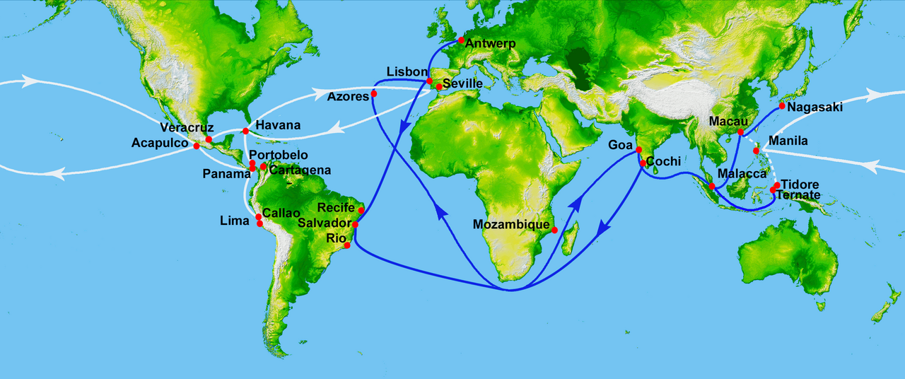
This round-the-world voyage gave Spain valuable knowledge of the world and its oceans which later helped in the exploration and settlement of the Philippines. Although this was not a realistic alternative to the Portuguese route around Africa[139] (the Strait of Magellan was too far south, and the Pacific Ocean too vast to cover in a single trip from Spain) successive Spanish expeditions used this information to explore the Pacific Ocean and discovered routes that opened up trade between Acapulco, New Spain (present-day Mexico) and Manila in the Philippines.[140]
,_The_Moluccas_(Maluku)_(15182126636).jpg/1280px-Pulau_Maitara_and_Pulau_Tidore_from_the_Floridas_Restaurant_in_Pulau_Ternate_(Ternate_Island),_The_Moluccas_(Maluku)_(15182126636).jpg)

Soon after Magellan's expedition, the Portuguese rushed to seize the surviving crew and built a fort in Ternate.[141] In 1525, Charles I of Spain sent another expedition westward to colonize the Maluku Islands, claiming that they were in his zone of the Treaty of Tordesillas. The fleet of seven ships and 450 men was led by García Jofre de Loaísa and included the most notable Spanish navigators: Juan Sebastián Elcano and Loaísa, who died then, and the young Andrés de Urdaneta.
Near the Strait of Magellan one of the ships was pushed south by a storm, reaching 56° S, where they thought seeing "earth's end": so Cape Horn was crossed for the first time. The expedition reached the islands with great difficulty, docking at Tidore.[141] The conflict with the Portuguese established in nearby Ternate was inevitable, starting nearly a decade of skirmishes.[143][144]
As there was not a set eastern limit to the Tordesillas line, both kingdoms organized meetings to resolve the issue. From 1524 to 1529, Portuguese and Spanish experts met at Badajoz-Elvas trying to find the exact location of the antimeridian of Tordesillas, which would divide the world into two equal hemispheres. Each crown appointed three astronomers and cartographers, three pilots, and three mathematicians. Lopo Homem, Portuguese cartographer and cosmographer was on the board, along with cartographer Diogo Ribeiro of the Spanish delegation. The board met several times without reaching an agreement: the knowledge at that time was insufficient for an accurate calculation of longitude, and each group gave the islands to its sovereign. The issue was settled only in 1529, after a long negotiation, with the signing of Treaty of Zaragoza, which allocated the Maluku Islands to Portugal and the Philippines to Spain.[145]
From 1525 to 1528, Portugal sent several expeditions around the Maluku Islands. Gomes de Sequeira and Diogo da Rocha were sent north by the governor of Ternate Jorge de Menezes, being the first Europeans to reach the Caroline Islands, which they named "Islands de Sequeira".[146] In 1526, Jorge de Meneses docked on Biak and Waigeo islands, Papua New Guinea. Based on these explorations stands the theory of Portuguese discovery of Australia, one among several competing theories about the early discovery of Australia, supported by Australian historian Kenneth McIntyre, stating it was discovered by Cristóvão de Mendonça and Gomes de Sequeira.
In 1527, Hernán Cortés fitted out a fleet to find new lands in the "South Sea" (Pacific Ocean), asking his cousin Álvaro de Saavedra Cerón to take charge. On 31 October 1527, Saavedra sailed from New Spain, crossing the Pacific and touring the north of New Guinea, then named Isla de Oro. In October 1528, one of the vessels reached the Maluku Islands. In his attempt to return to New Spain he was diverted by the northeast trade winds, which threw him back, so he tried sailing back down, to the south. He returned to New Guinea and sailed northeast, where he sighted the Marshall Islands and the Admiralty Islands, but again was surprised by the winds, which brought him a third time to the Moluccas. This westbound return route was hard to find but was eventually discovered by Andrés de Urdaneta in 1565.[147]
Rumors of undiscovered islands northwest of Hispaniola reached Spain by 1511, ushering King Ferdinand's interest in forestalling further exploration. While the Portuguese were making huge gains in the Indian Ocean, the Spanish invested in exploring inland in search of gold and other valuable resources. The members of these expeditions, the "conquistadors", were not soldiers in an army, but more like soldiers of fortune; they came from a variety of backgrounds including artisans, merchants, clergy, lawyers, lesser nobility and a few freed slaves. They usually supplied their own equipment or were extended credit to purchase it in exchange for a share in profits. They usually had no professional military training, but a number of them had previous experience on other expeditions.[148]
In the Americas, the Spanish encountered large indigenous empires and formed alliances with indigenous people through small expeditions. After establishing Spanish sovereignty and discovering wealth, the crown focused on implementing Spanish state and church institutions. A key element was the 'spiritual conquest' through Christian evangelization. The initial economy relied on a tribute and forced labor under the encomienda system. The discovery of vast silver deposits transformed both the colonial economies of Mexico and Peru and Spain’s economy. With global trade networks and valuable American crops, Spain's economy strengthened, enhancing its status as a world power.[citation needed]
During this time, pandemics of European diseases such as smallpox decimated the indigenous populations.[149]
In 1512, to reward Juan Ponce de León for exploring Puerto Rico in 1508, King Ferdinand urged him to seek these new lands. He would become governor of discovered lands but was to finance himself all exploration.[150] With three ships and about 200 men, Léon set out from Puerto Rico in March 1513. In April they sighted land and named it La Florida—because it was Easter (Florida) season—believing it was an island, becoming credited as the first European to land in the continent. The arrival location has been disputed between St. Augustine,[151] Ponce de León Inlet and Melbourne Beach. They headed south for further exploration and on April 8 encountered a current so strong that it pushed them backward: this was the first encounter with the Gulf Stream that would soon become the primary route for eastbound ships leaving the Spanish Indies bound for Europe.[152] They explored down the coast reaching Biscayne Bay, Dry Tortugas and then sailing southwest in an attempt to circle Cuba to return, reaching Grand Bahama on July.
In 1517, Cuba's governor Diego Velázquez de Cuéllar commissioned a fleet under the command of Hernández de Córdoba to explore the Yucatán peninsula. They reached the coast where Mayans invited them to land. They were attacked at night and only a remnant of the crew returned. Velázquez then commissioned another expedition led by his nephew Juan de Grijalva, who sailed south along the coast to Tabasco, part of the Aztec empire.
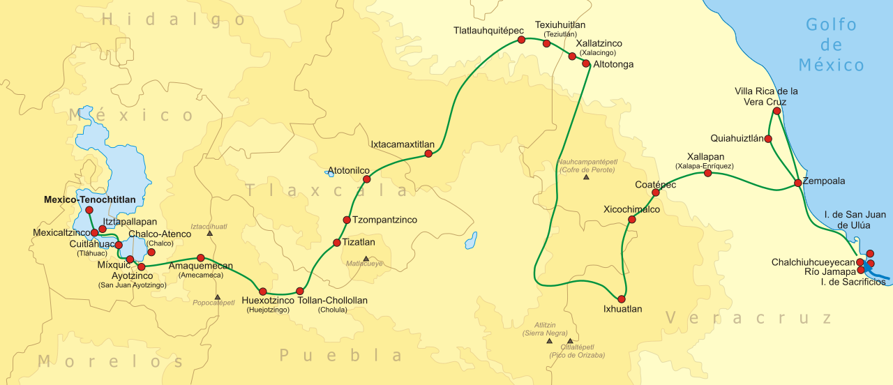
In 1518, Velázquez gave the mayor of the capital of Cuba, Hernán Cortés, the command of an expedition to secure the interior of Mexico but, due to an old gripe between them, revoked the charter. In February 1519, Cortés went ahead anyway, in an act of open mutiny. With about 11 ships, 500 men, 13 horses and a small number of cannons he landed in Yucatán, in Mayan territory,[153] claiming the land for the Spanish crown. From Trinidad he proceeded to Tabasco and won a battle against the natives. Among the vanquished was Marina (La Malinche), his future mistress, who knew both (Aztec) Nahuatl language and Maya, becoming a valuable interpreter and counsellor. Cortés learned about the wealthy Aztec Empire through La Malinche,
In July, his men took over Veracruz and he placed himself under direct orders of new king Charles I of Spain.[153] There Cortés asked for a meeting with Aztec Emperor Montezuma II, who repeatedly refused. They headed to Tenochtitlan and on the way made alliances with several tribes. In October, accompanied by about 3,000 Tlaxcaltec they marched to Cholula, the second largest city in central Mexico. Either to instill fear upon the Aztecs waiting for him or (as he later claimed) wishing to make an example when he feared native treachery, they massacred thousands of unarmed members of the nobility gathered at the central plaza and partially burned the city.

On November 8, Cortés and his large army were welcomed by Moctezuma II in Tenochtitlan, who hoped to learn about them to eventually defeat them.[153] Moctezuma gave lavish gifts, which led Cortés to plunder the city. Cortés claimed the Aztecs saw him as an emissary or incarnation of the god Quetzalcoatl, though this is contested by few historians.[154] Upon learning that his men had been attacked on the coast, Cortés took Moctezuma hostage in his palace, demanding tribute for King Charles.
Meanwhile, Velasquez sent another expedition, led by Pánfilo de Narváez, to oppose Cortès, arriving in Mexico in April 1520 with 1,100 men.[153] Cortés left 200 men in Tenochtitlan and took the rest to confront Narvaez, whom he overcame, convincing his men to join him. In Tenochtitlán one of Cortés's lieutenants committed a massacre in the Great Temple, triggering local rebellion. Cortés speedily returned, attempting the support of Moctezuma but the Aztec emperor was killed, possibly stoned by his subjects.[155] The Spanish fled for the Tlaxcaltec during the Noche Triste, where they managed a narrow escape while their back guard was massacred. Much of the treasure looted was lost during this panicked escape.[153] After a battle in Otumba they reached Tlaxcala, having lost 870 men.[153] Having prevailed with the assistance of allies and reinforcements from Cuba, Cortés besieged Tenochtitlán and captured its ruler Cuauhtémoc in August 1521. As the Aztec Empire ended he claimed the city for Spain, renaming it Mexico City.

A first attempt to explore western South America was undertaken in 1522 by Pascual de Andagoya. Native South Americans told him about a gold-rich territory on a river called Pirú. Having reached San Juan River (Colombia), Andagoya fell ill and returned to Panama, where he spread the news about "Pirú" as the legendary El Dorado. These, along with the accounts of the success of Hernán Cortés, caught the attention of Pizarro.
Francisco Pizarro had accompanied Balboa in the crossing of the Isthmus of Panama. In 1524 he formed a partnership with priest Hernando de Luque and soldier Diego de Almagro to explore the south, agreeing to divide the profits. They dubbed the enterprise the "Empresa del Levante": Pizarro would command, Almagro would provide military and food supplies, and Luque would be in charge of finances and additional provisions.
On 13 September 1524, the first of three expeditions set out to conquer Peru with 80 men and 40 horses. The venture failed, halting in Colombia due to bad weather, hunger, and conflicts with locals; Almagro lost an eye. Their route was marked by Puerto Deseado (desired port), Puerto del Hambre (port of hunger), and Puerto quemado (burned port). Two years later, a second expedition began with reluctant permission from the Governor of Panama. In August 1526, they departed with two ships, 160 men, and horses. Upon reaching the San Juan River, Pizarro explored swampy coasts, while Almagro sought reinforcements. Pizarro's pilot, sailing south and crossing the equator, captured a raft from Tumbes. To his surprise, the raft carried coveted textiles, ceramics, gold, silver, and emeralds, becoming the expedition's main focus. Almagro later joined with reinforcements, and despite challenging conditions, they reached Atacames, where a sizable native population under Inca rule was observed, though they did not land.
Pizarro, safe near the coast, sent Almagro and Luque for reinforcements with proof if the rumoured gold. The new governor rejected a third expedition, ordering everyone back to Panama. Almagro and Luque seized the chance to rejoin Pizarro. At Isla de Gallo, Pizarro drew a line, presenting the choice between Peru's riches and Panama's poverty. Thirteen men, The Famous Thirteen, stayed and headed to La Isla Gorgona, staying seven months until provisions arrived.
They sailed south and by April 1528, reached northwestern Peru's Tumbes Region, warmly received by the Tumpis. Pizarro's men reported incredible riches, llama sightings, and the natives named them "Children of the Sun" for their fair complexion and brilliant armour. They decided to return to Panama to prepare a final expedition, sailing south through named territories like Cabo Blanco, port of Payta, Sechura, Punta de Aguja, Santa Cruz, and Trujillo, reaching the ninth degree south.
In the spring of 1528, Pizarro sailed for Spain, where he had an interview with king Charles I. The king heard of his expeditions in lands rich in gold and silver and promised to support him. The Capitulación de Toledo[156] authorized Pizarro to proceed with the conquest of Peru. Pizarro was then able to convince many friends and relatives to join: his brothers Hernándo Pizarro, Juan Pizarro, Gonzalo Pizarro and also Francisco de Orellana, who would later explore the Amazon River, as well as his cousin Pedro Pizarro.
Pizarro's third and final expedition left Panama for Peru on 27 December 1530. With three ships and one hundred and eighty men, they landed near Ecuador and sailed to Tumbes, finding the place destroyed. They entered the interior and established the first Spanish settlement in Peru, San Miguel de Piura. One of the men returned with an Incan envoy and an invitation for a meeting. Since the last meeting, the Inca had begun a civil war and Atahualpa had been resting in northern Peru following the defeat of his brother Huáscar. After marching for two months, they approached Atahualpa. He refused the Spanish, saying he would be "no man's tributary". There were fewer than 200 Spanish to his 80,000 soldiers, but Pizarro attacked and won the Incan army in the Battle of Cajamarca, taking Atahualpa captive at the so-called ransom room. Despite fulfilling his promise of filling one room with gold and two with silver, he was convicted for killing his brother and plotting against Pizarro, and was executed.
In 1533, Pizarro invaded Cuzco with indigenous troops and wrote to King Charles I: "This city is the greatest and the finest ever seen in this country or anywhere in the Indies ... it is so beautiful and has such fine buildings that it would be remarkable even in Spain." After the Spanish had sealed the conquest of Peru, Jauja in fertile Mantaro Valley was established as Peru's provisional capital, but it was too far up in the mountains, and Pizarro founded the city of Lima on 18 January 1535, which Pizarro considered one of the most important acts in his life.
In 1543, three Portuguese traders accidentally became the first Westerners to reach and trade with Japan. According to Fernão Mendes Pinto, who claimed to be in this journey, they arrived at Tanegashima, where the locals were impressed by firearms that would be immediately made by the Japanese on a large scale.[157]
The Spanish conquest of the Philippines was ordered by Philip II of Spain, and Andrés de Urdaneta was the designated commander. Urdaneta agreed to accompany the expedition but refused to command and Miguel López de Legazpi was appointed instead. The expedition set sail on November 1564.[158] After spending some time on the islands, Legazpi sent Urdaneta back to find a better return route. Urdaneta set sail from San Miguel on the island of Cebu on 1 June 1565, but was obliged to sail as far as 38 degrees North latitude to obtain favorable winds.

He reasoned that the trade winds of the Pacific might move in a gyre as the Atlantic winds did. If in the Atlantic, ships made the Volta do mar to pick up winds that would bring them back from Madeira, then, he reasoned, by sailing far to the north before heading east, he would pick up trade winds to bring him back to North America. His hunch paid off, and he hit the coast near Cape Mendocino, California, then followed the coast south. The ship reached the port of Acapulco, on 8 October 1565, having traveled 12,000 miles (19,000 kilometres) in 130 days. Fourteen of his crew died; only Urdaneta and Felipe de Salcedo, nephew of López de Legazpi, had strength enough to cast the anchors.
Thus, a cross-Pacific Spanish route was established, between Mexico and the Philippines. For a long time, these routes were used by the Manila galleons, thereby creating a trade link joining China, the Americas, and Europe via the combined trans-Pacific and trans-Atlantic routes.
European nations outside Iberia did not recognize the Treaty of Tordesillas between Portugal and Castile, nor did they recognize Pope Alexander VI's donation of the Spanish finds in the New World. France, the Netherlands and England each had a long maritime tradition and had been engaging in privateering. Despite Iberian protections, the new technologies and maps soon made their way north.
After the marriage of Henry VIII of England and Catherine of Aragon failed to produce a male heir and Henry failed to obtain a papal dispensation to annul his marriage, he broke with the Roman Catholic Church and established himself as head of the Church of England. This added religious conflict to political conflict. When much of The Netherlands became Protestant, it sought political and religious independence from Catholic Spain. In 1568, the Dutch rebelled against the rule of Philip II of Spain leading to the Eighty Years' War. The war between England and Spain also broke out. In 1580, Philip II became King of Portugal, as heir to its Crown. Although he ruled Portugal and its empire as separate from the Spanish Empire, the union of the crowns produced a Catholic superpower, which England and the Netherlands challenged.
In the eighty-year Dutch War of Independence, Philip's troops conquered the important trading cities of Bruges and Ghent. Antwerp, then the most important port in the world, fell in 1585.[citation needed] The Protestant population was given two years to settle affairs before leaving the city.[159] Many settled in Amsterdam. Those were mainly skilled craftsmen, rich merchants of the port cities and refugees that fled religious persecution, particularly Sephardi Jews from Portugal and Spain and, later, the Huguenots from France. The Pilgrim Fathers also spent time there before going to the New World. This mass immigration was an important driving force: a small port in 1585, Amsterdam quickly transformed into one of the most important commercial centres in the world. After the failure of the Spanish Armada in 1588, there was a huge expansion of maritime trade even though the defeat of the English Armada would confirm the naval supremacy of the Spanish navy over the emergent competitors.
Dutch maritime power rose quickly as Dutch sailors, skilled in navigation and mapmaking, engaged with Portuguese voyages. In 1592, Cornelis de Houtman gathered information on the Spice Islands in Lisbon. The same year, Jan Huyghen van Linschoten published a detailed travel report in Amsterdam, providing navigation instructions for reaching the East Indies and Japan.[160] Following this, Houtman led the Dutch’s first exploratory voyage, discovering a new route from Madagascar to the Sunda Strait and securing a treaty with the Banten Sultan. The Dutch also demonstrated their maritime strength by seizing Malacca from Portugal in 1641, following a series of battles that began in 1602.
Dutch and British interest, fed on new information, led to a movement of commercial expansion, and the foundation of English (1600), and Dutch (1602) chartered companies. Dutch, French, and English sent ships which flouted the Portuguese monopoly, concentrated mostly on the coastal areas, which proved unable to defend against such a vast and dispersed venture.[161]

The 1497 English expedition authorized by Henry VII of England was led by Italian Venetian John Cabot (Giovanni Caboto); it was the first of a series of French and English missions exploring North America. Mariners from the Italian peninsula played an important role in early explorations, most especially Genoese mariner Christopher Columbus. With its major conquests of central Mexico and Peru and discoveries of silver, Spain put limited efforts into exploring the northern part of the Americas; its resources were concentrated in Central and South America where more wealth had been found.[162] These other European expeditions were initially motivated by the same idea as Columbus, namely a westerly shortcut to the Asian mainland. After the existence of "another ocean" (the Pacific) was confirmed by Balboa in 1513, there still remained the motivation of potentially finding an oceanic Northwest Passage for Asian trade.[162] This was not discovered until the early twentieth century, but other possibilities were found, although nothing on the scale of the spectacular ones of the Spanish. In the early 17th century colonists from a number of Northern European states began to settle on the east coast of North America. Between 1520 and 1521, the Portuguese João Álvares Fagundes, accompanied by couples of mainland Portugal and the Azores, explored Newfoundland and Nova Scotia (possibly reaching the Bay of Fundy on the Minas Basin[163]), and established a fishing colony on the Cape Breton Island that would last until at least the 1570s or near the end of the century.[164]
In 1524, Italian Giovanni da Verrazzano sailed under the authority of Francis I of France, who was motivated by indignation over the division of the world between Portuguese and Spanish. Verrazzano explored the Atlantic Coast of North America, from South Carolina to Newfoundland, and was the first recorded European to visit what would later become the Virginia Colony and the United States. In the same year Estevão Gomes, a Portuguese cartographer who had sailed in Ferdinand Magellan's fleet, explored Nova Scotia, sailing South through Maine, where he entered what is now New York Harbor, the Hudson River and eventually reached Florida in August 1525. As a result of his expedition, the 1529 Diogo Ribeiro world map outlines the East coast of North America almost perfectly. From 1534 to 1536, French explorer Jacques Cartier, believed to have accompanied Verrazzano to Nova Scotia and Brazil, was the first European to travel inland in North America, describing the Gulf of Saint Lawrence, which he named "The Country of Canadas", after Iroquois names, claiming what is now Canada for Francis I of France.[165][166]

Europeans explored the Pacific Coast beginning in the mid-16th century. Spaniards Francisco de Ulloa explored the Pacific coast of present-day Mexico including the Gulf of California, proving that Baja California was a peninsula.[167] Despite his report based on first-hand information, the myth persisted in Europe that California was an island. His account provided the first recorded use of the name "California". João Rodrigues Cabrilho, a Portuguese navigator sailing for the Spanish Crown, was the first European to set foot in California, landing on September 28, 1542, on the shores of San Diego Bay and claiming California for Spain.[168] He also landed on San Miguel, one of the Channel Islands, and continued as far north as Point Reyes on the mainland. After his death, the crew continued exploring as far north as Oregon.
The English privateer Francis Drake sailed along the coast in 1579 north of Cabrillo's landing site while circumnavigating the world. Drake had a long and largely successful career attacking Spanish settlements in the Caribbean islands and the mainland so for the English, he was a great hero and fervent Protestant, but for the Spanish, he was "a frightening monster." Drake played a major role in the defeat of the Spanish Armada in 1588 but led an armada himself to the Spanish Caribbean that was unsuccessful in dislodging the Spanish.[169] On 5 June 1579, the ship briefly made first landfall at South Cove, Cape Arago, just south of Coos Bay, Oregon, and then sailed south while searching for a suitable harbor to repair his damaged ship.[170][171][172][173][174] On 17 June, Drake and his crew found a protected cove when they landed on the Pacific coast of what is now Northern California near Point Reyes.[175][173] While ashore, he claimed the area for Queen Elizabeth I of England as Nova Albion or New Albion.[176] To document and assert his claim, Drake posted an engraved plate of brass to claim sovereignty for Queen Elizabeth and her successors on the throne.[177] Drake's landfalls on the west coast of North America are one small part of his 1577-1580 circumnavigation of the globe, the first captain of his own ship to do so. Drake died in 1596 off the coast of Panama, following injuries from a raid.[178]
From 1609 to 1611, after several voyages on behalf of English merchants to explore a prospective Northeast Passage to India, English mariner Henry Hudson, under the auspices of the Dutch East India Company (VOC), explored the region around present-day New York City, while looking for a western route to Asia. He explored the Hudson River and laid the foundation for Dutch colonization of the region. Hudson's final expedition ranged farther north in search of the Northwest Passage, leading to his discovery of the Hudson Strait and Hudson Bay. After wintering in James Bay, Hudson tried to press on with his voyage in the spring of 1611, but his crew mutinied and they cast him adrift.

France, the Netherlands, and England sought a sea route to Asia after finding none through Africa or South America. With no route through the Americas, they focused on northern passages, driving European exploration of the Arctic coasts. The idea of a link between the Atlantic and Pacific was first proposed by Russian diplomat Gerasimov in 1525, though Russian Pomors had explored parts of the route as early as the 11th century.[citation needed]
In 1553, English explorer Hugh Willoughby with chief pilot Richard Chancellor were sent out with three vessels in search of a passage by London's Company of Merchant Adventurers to New Lands. During the voyage across the Barents Sea, Willoughby thought he saw islands to the north, and islands called Willoughby's Land were shown on maps published by Plancius and Mercator into the 1640s.[179] The vessels were separated by "terrible whirlwinds" in the Norwegian Sea and Willoughby sailed into a bay near the present border between Finland and Russia. His ships with the frozen crews, including Captain Willoughby and his journal, were found by Russian fishermen a year later. Richard Chancellor was able to drop anchor in the White Sea and make his way overland to Moscow and Ivan the Terrible's Court, opening trade with Russia and the Company of Merchant Adventurers became the Muscovy Company.
In June 1576, English mariner Martin Frobisher led an expedition consisting of three ships and 35 men to search for a north-west passage around North America. The voyage was supported by the Muscovy Company, the same merchants that hired Hugh Willoughby to find a northeast passage above Russia. Violent storms sank one ship and forced another to turn back but Frobisher and the remaining ship reached the coast of Labrador in July. A few days later they came upon the mouth of what is now Frobisher Bay. Frobisher believed it to be the entrance to a north-west passage and named it Frobisher's Strait and claimed Baffin Island for Queen Elizabeth. After some preliminary exploration, Frobisher returned to England. He commanded two subsequent voyages in 1577 and 1578 but failed to find the hoped-for passage.[180] Frobisher brought to England his ships laden with ore, but it was found to be worthless and damaged his reputation as an explorer. He remains an important early historical figure in Canada.[181]

On 5 June 1594, Dutch cartographer Willem Barentsz departed from Texel in a fleet of three ships to enter the Kara Sea, with the hopes of finding the Northeast Passage above Siberia.[182] At Williams Island the crew encountered a polar bear for the first time. They managed to bring it on board, but the bear rampaged and was killed. Barentsz reached the west coast of Novaya Zemlya and followed it northward, before being forced to turn back in the face of large icebergs.
The following year, Prince Maurice of Orange named him chief pilot of a new expedition of six ships, loaded with merchant wares that the Dutch hoped to trade with China.[183] The party came across Samoyed "wild men" but eventually turned back upon discovering the Kara Sea frozen. In 1596, the States-General offered a high reward for anybody who successfully navigated the Northeast Passage. The Town Council of Amsterdam purchased and outfitted two small ships, captained by Jan Rijp and Jacob van Heemskerk, to search for the elusive channel, under the command of Barents. They set off in May, and in June discovered Bear Island and Spitsbergen, sighting its northwest coast. They saw a large bay, later called Raudfjorden and entered Magdalenefjorden, which they named Tusk Bay, sailing into the northern entrance of Forlandsundet, which they called Keerwyck, but were forced to turn back because of a shoal. On 28 June they rounded the northern point of Prins Karls Forland, which they named Vogelhoek, on account of a large number of birds, and sailed south, passing Isfjorden and Bellsund, which were labelled on Barentsz's chart as Grooten Inwyck and Inwyck.
.jpg/1280px-Polar_bear,_Gerrit_de_Veer_(1596).jpg)
The ships once again reached Bear Island on 1 July, which led to a disagreement. They parted ways, with Barentsz continuing northeast, while Rijp headed north. Barentsz reached Novaya Zemlya and, to avoid becoming entrapped in ice, headed for the Vaigatch Strait but became stuck within the icebergs and floes. Stranded, the 16-man crew was forced to spend the winter on the ice. The crew used lumber from their ship to build a lodge they called Het Behouden Huys (The Kept House). Dealing with extreme cold, they used merchant fabrics to make additional blankets and clothing and caught Arctic foxes in primitive traps, as well as polar bears. When June arrived, and the ice had still not loosened its grip on the ship, scurvy-ridden survivors took two small boats out into the sea. Barentsz died at sea on 20 June 1597, while studying charts. It took seven more weeks for the boats to reach Kola where they were rescued by a Russian merchant vessel. Only 12 crewmen remained, reaching Amsterdam in November. Two of Barentsz' crewmembers later published their journals, Jan Huyghen van Linschoten, who had accompanied him on the first two voyages, and Gerrit de Veer who had acted as the ship's carpenter on the last.
In 1608, Henry Hudson made a second attempt, trying to go across the top of Russia. He made it to Novaya Zemlya but was forced to turn back. Between 1609 and 1611, Hudson, after several voyages on behalf of English merchants to explore a prospective Northern Sea Route to India, explored the region around modern New York City while looking for a western route to Asia under the auspices of the Dutch East India Company (VOC).
Terra Australis Ignota (Latin, "the unknown land of the south") was a hypothetical continent appearing on European maps from the 15th to the 18th centuries, with roots in a notion introduced by Aristotle. It was depicted on the mid-16th-century Dieppe maps, where its coastline appeared just south of the islands of the East Indies; it was often elaborately charted, with a wealth of fictitious detail. The discoveries reduced the area where the continent could be found. Many cartographers held to Aristotle's opinion, like Gerardus Mercator (1569) and Alexander Dalrymple even so late as 1767[184] argued for its existence, with such arguments as that there should be a large landmass in the Southern Hemisphere as a counterweight to the known landmasses in the Northern Hemisphere. As new lands were discovered, they were often assumed to be parts of this hypothetical continent.
Juan Fernández, sailing from Chile in 1576, claimed he had discovered the Southern Continent.[185] Luis Váez de Torres, a Galician navigator working for the Spanish Crown, proved the existence of a passage south of New Guinea, now known as Torres Strait. Pedro Fernandes de Queirós, a Portuguese navigator sailing for the Spanish Crown, saw a large island south of New Guinea in 1606, which he named La Australia del Espiritu Santo. He represented this to the King of Spain as the Terra Australis incognita. It was not Australia but an island in present-day Vanuatu.

Dutch navigator and colonial governor, Willem Janszoon sailed from the Netherlands for the East Indies for the third time on December 18, 1603, as captain of the Duyfken (or Duijfken, meaning "Little Dove"), one of twelve ships of the great fleet of Steven van der Hagen.[186] Once in the Indies, Janszoon was sent to search for other outlets of trade, particularly in "the great land of Nova Guinea and other East and Southlands." On November 18, 1605, the Duyfken sailed from Bantam to the coast of western New Guinea. Janszoon then crossed the eastern end of the Arafura Sea, without seeing the Torres Strait, into the Gulf of Carpentaria. On February 26, 1606, he made landfall at the Pennefather River on the western shore of Cape York in Queensland, near the modern town of Weipa. This is the first recorded European landfall on the Australian continent. Janszoon proceeded to chart some 320 kilometres (199 miles) of the coastline, which he thought was a southerly extension of New Guinea. In 1615, Jacob Le Maire and Willem Schouten's rounding of Cape Horn proved that Tierra del Fuego was a relatively small island.
From 1642 to 1644, Abel Tasman, also a Dutch explorer and merchant in the service of the VOC, circumnavigated New Holland proving that Australia was not part of the mythical southern continent. He was the first known European expedition to reach the islands of Van Diemen's Land (now Tasmania) and New Zealand and to sight the Fiji islands, which he did in 1643. Tasman, his navigator Visscher, and his merchant Gilsemans also mapped substantial portions of Australia, New Zealand, and the Pacific Islands.

In the mid-16th century, the Tsardom of Russia conquered the Tatar khanates of Kazan and Astrakhan, thus annexing the entire Volga Region and opening the way to the Ural Mountains. The colonization of the new easternmost lands of Russia and further onslaught eastward was led by the rich merchants Stroganovs. Tsar Ivan IV granted vast estates near the Urals as well as tax privileges to Anikey Stroganov, who organized large-scale migration to these lands. Stroganovs developed farming, hunting, saltworks, fishing, and ore mining on the Urals and established trade with Siberian tribes.
Around 1577, Semyon Stroganov and other sons of Anikey Stroganov hired a Cossack leader called Yermak to protect their lands from the attacks of Khan Kuchum. By 1580, Stroganovs and Yermak came up with the idea of a military expedition to Siberia, to fight Kuchum in his own land. In 1581, Yermak began his voyage into the depths of Siberia. After a few victories over the Khan's army, Yermak's people defeated the main forces of Kuchum on Irtysh River in a 3-day Battle of Chuvash Cape in 1582. The remains of the Khan's army retreated to the steppes, and thus Yermak captured the Khanate of Sibir, including its capital Qashliq near modern Tobolsk. Kuchum still was strong and suddenly attacked Yermak in 1585 in the dead of night, killing most of his people. Yermak was wounded and tried to swim across the Wagay River (Irtysh's tributary), but drowned under the weight of his own chain mail. The Cossacks had to withdraw from Siberia completely, but thanks to Yermak's having explored all the main river routes in West Siberia, Russians successfully reclaimed all his conquests just several years later.

In the early 17th century, the eastward movement of Russians was slowed by the internal problems in the country during the Time of Troubles. Very soon, exploration and colonization of the huge territories of Siberia resumed, led mostly by Cossacks hunting for valuable furs and ivory. While Cossacks came from the Southern Urals, another wave of Russians came by the Arctic Ocean. These were Pomors from the Russian North, who already had been making fur trade with Mangazeya in the north of Western Siberia for quite a long time. In 1607, the settlement of Turukhansk was founded on the northern Yenisey River, near the mouth of Lower Tunguska. In 1619, Yeniseysk ostrog was founded on the mid-Yenisey at the mouth of the Upper Tunguska.
Between 1620 and 1624, a group of fur hunters led by Demid Pyanda left Turukhansk and explored some 1,430 miles (2,300 kilometres) of the Lower Tunguska, wintering in the proximity of the Vilyuy and Lena Rivers. According to later legendary accounts (folktales collected a century after the fact), Pyanda discovered the Lena. He allegedly explored some 1,500 miles (2,400 kilometres) of its length, reaching as far as central Yakutia. He returned up the Lena until it became too rocky and shallow, and portaged to the Angara River. In this way, Pyanda may have become the first Russian to meet Yakuts and Buryats. He built new boats and explored some 870 miles (1,400 kilometres) of the Angara, finally reaching Yeniseysk and discovering that the Angara (a Buryat name) and Upper Tunguska (Verkhnyaya Tunguska, as initially known by Russians) are one and the same river.
In 1627, Pyotr Beketov was appointed Yenisei voevoda in Siberia. He successfully carried out the voyage to collect taxes from the Zabaykalye Buryats, becoming the first Russian to step in Buryatia. He founded the first Russian settlement there, Rybinsky ostrog. Beketov was sent to the Lena River in 1631, where in 1632 he founded Yakutsk and sent his Cossacks to explore the Aldan River and farther down the Lena, to found new fortresses, and to collect taxes.[187]
Yakutsk soon turned into a major starting point for further Russian expeditions eastward, southward and northward. Maksim Perfilyev, who earlier had been one of the founders of Yeniseysk, founded Bratsk ostrog on the Angara in 1631. In 1638, Perfilyev became the first Russian to step into Transbaikalia, travelling there from Yakutsk.[188][189]

In 1643, Kurbat Ivanov led a group of Cossacks from Yakutsk to the south of the Baikal Mountains and discovered Lake Baikal, visiting its Olkhon Island. Ivanov later made the first chart and description of Baikal.[190]
In 1639, a group of explorers led by Ivan Moskvitin became the first Russians to reach the Pacific Ocean and to discover the Sea of Okhotsk, having built a winter camp on its shore at the Ulya River mouth. The Cossacks learned from the locals about the large Amur River far to the south. In 1640, they apparently sailed south, and explored the south-eastern shores of the Okhotsk Sea, perhaps reaching the mouth of the Amur River and possibly discovering the Shantar Islands on their way back. Based on Moskvitin's account, Kurbat Ivanov drew the first Russian map of the Far East in 1642.
In 1643, Vasily Poyarkov crossed the Stanovoy Range and reached the upper Zeya River in the country of the Daurs, who were paying tribute to the Manchu Chinese. After wintering, in 1644, Poyarkov pushed down the Zeya and became the first Russian to reach the Amur River. He sailed down the Amur and finally discovered the mouth of that great river from land. Since his Cossacks provoked the enmity of the locals behind, Poyarkov chose a different way back. They built boats and in 1645, sailed along the Sea of Okhotsk coast to the Ulya River and spent the next winter in the huts that had been built by Ivan Moskvitin six years earlier. In 1646, they returned to Yakutsk.

In 1644, Mikhail Stadukhin discovered the Kolyma River and founded Srednekolymsk. A merchant named Fedot Alekseyev Popov organized a further expedition eastward, and Semyon Dezhnyov became a captain of one of the kochi. In 1648, they sailed from Srednekolymsk down to the Arctic and after some time they rounded Cape Dezhnyov, thus becoming the first explorers to pass through the Bering Strait and discover Chukotka and the Bering Sea. All their Kochi and most of their men (including Popov himself) were lost in storms and clashes with the natives. A small group led by Dezhnyov reached the mouth of the Anadyr River and sailed up it in 1649, having built new boats from the wreckage. They founded Anadyrsk and were stranded there until Stadukhin found them, coming from Kolyma by land.[191] Subsequently, Stadukhin set off south in 1651 and discovered Penzhin Bay on the northern coast of the Okhotsk Sea. He also may have explored the western shores of Kamchatka.
From 1649 to 1650, Yerofey Khabarov became the second Russian to explore the Amur River. Through Olyokma, Tungir and Shilka Rivers he reached Amur (Dauria), returned to Yakutsk and then back to Amur with a larger force in 1650–1653. This time he was met with armed resistance. He built winter quarters at Albazin, then sailed down Amur and found Achansk, which preceded the present-day Khabarovsk, defeating or evading large armies of Daurian Manchu Chinese and Koreans on his way. He charted the Amur in his Draft of the Amur river.[192] Subsequently, Russians held on to the Amur region until 1689, when by the Treaty of Nerchinsk this land was assigned to the Chinese Empire. It was returned by the Treaty of Aigun in 1858.
From 1659 to 1665, Kurbat Ivanov was the next head of Anadyrsky ostrog after Semyon Dezhnev. In 1660, he sailed from Anadyr Bay to Cape Dezhnyov. Atop his earlier pioneering charts, Ivanov is credited with the creation of the early map of Chukotka and the Bering Strait, which was the first to show on paper (very schematically) the yet undiscovered Wrangel Island, both Diomede Islands and Alaska, based on the data collected from the natives of Chukotka.
By the mid-17th century, Russians established the borders of their country close to modern ones, and explored almost the whole of Siberia, except the eastern Kamchatka and some regions north of the Arctic Circle. The conquest of Kamchatka later would be achieved in the early 1700s by Vladimir Atlasov, while the discovery of the Arctic coastline and Alaska would be completed by the Great Northern Expedition in 1733–1743.

European overseas expansion led to contact between the Old and New Worlds producing the Columbian exchange.[193] It started the global silver trade and led to direct European involvement in the Chinese porcelain trade. It involved the transfer of goods unique from one hemisphere to another. Europeans brought cattle, horses, and sheep to the New World, and from the New World Europeans received tobacco, potatoes, tomatoes, and maize. Other items and commodities becoming important in global trade were the tobacco, sugarcane, and cotton crops of the Americas, along with the gold and silver brought from the American continent not only to Europe, but elsewhere in the Old World.[194][195][196][197]
The formation of new transoceanic links and expansion of European influence led to the Age of Imperialism, which began during the Age of Discovery, during which colonial powers from Europe colonized most territory on the planet. European demand for trade, commodities, colonies and slaves had a drastic impact on the rest of the world; during European colonization of the Americas, European colonial powers conquered and colonized numerous indigenous nations and cultures, and conducted numerous conversions and attempts at cultural assimilation both voluntary or forced. Combined with the introduction of infectious diseases from Europe, these events led to a drastic decrease of the indigenous American population. Indigenous accounts of European colonization were summarized by scholar Peter Mancall: "The arrival of Europeans brought death, displacement, sorrow, and despair to Native Americans".[198] In some areas, like North America, Central America, Australia, New Zealand, and Argentina, indigenous peoples were badly treated, driven off their lands, and reduced to dependent minorities in the territory.

Similarly, in East and West Africa, local states supplied the appetite of European slave traders, changing the complexion of coastal African states and fundamentally altering the nature of slavery in Africa, causing impacts on societies and economies deep inland.[196]
In North America, there were many conflicts between Europeans and indigenous peoples. The Europeans had many advantages over the indigenous people. Introduced Eurasian diseases wiped out 50–90% of the indigenous population because they had not been exposed before and lacked acquired immunity.[199]
Maize and manioc were introduced into Africa in the 16th century by the Portuguese.[200] They are now important staple foods, replacing native African crops.[201][202] Alfred W. Crosby speculated that increased production of maize, manioc, and other New World crops led to heavier concentrations of population in the areas from which slavers captured their victims.[203]
In the global silver trade, the Ming dynasty was stimulated by trade with the Portuguese, Spanish, and Dutch. Although global, much of that silver ended up with the Chinese, and China dominated silver imports.[204] Between 1600 and 1800 China received 100 tons of silver on average per year. A large populace near the Lower Yangtze averaged hundreds of taels of silver per household in the late 16th century.[205] More than 150,000 tons of silver were shipped from Potosí by the end of the 18th century. From 1500 to 1800, Mexico and Peru produced about 80%[206] of the world's silver, with more than 30% of it eventually ending up in China (largely because European merchants used it to purchase exotic Chinese commodities). In the late 16th and early 17th century, Japan was exporting heavily into China and foreign trade at large.[206] Trade with European powers and the Japanese brought in significant amounts of silver, which then replaced copper and paper banknotes as the common medium of exchange in China. During the last decades of the Ming Dynasty, the flow of silver into China was greatly diminished, thereby undermining state revenues and the entire Ming economy. This damage to the economy was compounded by the effects on agriculture of the incipient Little Ice Age, natural calamities, crop failure, and sudden epidemics. The ensuing breakdown of authority and people's livelihoods allowed rebel leaders such as Li Zicheng to challenge Ming authority.

New crops that had come to Asia from the Americas, via the Spanish colonizers in the 16th century, contributed to Asia's population growth.[207] Although the bulk of imports to China were silver, the Chinese also purchased New World crops from the Spanish Empire. This included sweet potatoes, maize, and peanuts, foods that could be cultivated in lands where traditional Chinese staple crops—wheat, millet, and rice—could not grow, hence facilitating a rise in the population of China.[208][209] In the Song dynasty (960–1279), rice had become the major staple crop of the poor;[210] after sweet potatoes were introduced to China around 1560, it gradually became the traditional food of the lower classes.[211]
The arrival of the Portuguese to Japan in 1543 initiated the Nanban trade period, with the Japanese adopting technologies and cultural practices, like the arquebus, European-style cuirasses, European ships, Christianity, decorative art, and language. After the Chinese had banned direct trade by Chinese merchants with Japan, the Portuguese filled this commercial vacuum as intermediaries. The Portuguese bought Chinese silk and sold it to the Japanese in return for Japanese-mined silver; since silver was more highly valued in China, the Portuguese could then use Japanese silver to buy even larger stocks of Chinese silk.[212] By 1573, after the Spanish established a trading base in Manila, the Portuguese intermediary trade was trumped by the prime source of incoming silver to China from the Spanish Americas.[213] Although China acted as the cog running the wheel of global trade during the 16th to 18th centuries, Japan's huge contribution of silver exports to China was critical to the world economy and China's liquidity and success with the commodity.[214]
As a wider variety of global luxury commodities entered the European markets by sea, previous European markets for luxury goods stagnated. The Atlantic trade largely supplanted pre-existing Italian and German trading powers which had relied on their Baltic, Russian, and Islamic trade links. The new commodities also caused social change, as sugar, spices, silks and chinawares entered the luxury markets of Europe.
The European economic centre shifted from the Mediterranean to Western Europe. The city of Antwerp, part of the Duchy of Brabant, became "the centre of the entire international economy",[215] and the richest city in Europe.[216] Centred in Antwerp first and then Amsterdam, the "Dutch Golden Age" was tightly linked to the Age of Discovery.
By 1549 the Portuguese were sending annual trade missions to Shangchuan Island in China. In 1557 they managed to convince the Ming court to agree on a legal port treaty that would establish Macau as an official Portuguese trade colony.[217] The Portuguese friar Gaspar da Cruz (c. 1520–70) wrote the first complete book on China published in Europe; it included information on its geography, provinces, royalty, official class, bureaucracy, shipping, architecture, farming, craftsmanship, merchant affairs, clothing, religious and social customs, music and instruments, writing, education, and justice.[218]

From China, the major exports were silk and porcelain, adapted to meet European tastes. The Chinese export porcelains were held in such great esteem in Europe that, in English, china became a commonly-used synonym for porcelain. Kraak porcelain was among the first Chinese ware to arrive in Europe in significant quantities; only the richest could afford these early imports.[219] Soon the Dutch East India Company established trade with the East, having imported 6 million porcelain items from China to Europe between the years 1602–82.[220][221] Kraak, mainly the blue and white porcelain, was imitated all over the world by potters in Arita, Japan and Persia—where Dutch merchants turned when the fall of the Ming dynasty rendered Chinese originals unavailable[222]—and ultimately in Delftware. Dutch and later English Delftware inspired by Chinese designs persisted from about 1630 to the mid-18th century alongside European patterns.
Antonio de Morga (1559–1636), a Spanish official in Manila, listed an extensive inventory of goods that were traded by Ming China at the turn of the 16th to 17th century, noting there were "rarities which, did I refer to them all, I would never finish, nor have sufficient paper for it".[223] Ebrey writes of the considerable size of commercial transactions: In one case a galleon to the Spanish territories in the New World carried over 50,000 pairs of silk stockings. In return China imported mostly silver from Peruvian and Mexican mines, transported via Manila. Chinese merchants were active in these trading ventures, and many emigrated to such places as the Philippines and Borneo to take advantage of the new commercial opportunities.[208]
The increase in gold and silver experienced by Spain coincided with a major inflationary cycle within Spain and Europe, known as the price revolution. Spain had amassed large quantities of gold and silver from the New World.[224] In the 1540s large scale extraction of silver from Mexico began. During the 16th century, Spain held the equivalent of US$1.5 trillion (1990 terms) in gold and silver from New Spain. Being the most powerful European monarch at a time full of war and religious conflicts, the Habsburg rulers spent their wealth in wars and arts across Europe. "I learnt a proverb here", said a French traveller in 1603: "Everything is dear in Spain except silver".[225] The spent silver, spread throughout a cash-starved Europe, caused widespread inflation.[226] The inflation was worsened by a growing population with a static production level, low salaries and a rising cost of living, which damaged local industry. Increasingly, Spain became dependent on the revenues flowing in from the mercantile empire, leading to Spain's first bankruptcy in 1557 due to rising military costs.[227] Philip II of Spain defaulted on debt payments in 1557, 1560, 1575, and 1596. The increase in prices as a result of currency circulation fuelled the growth of the commercial middle class in Europe, the bourgeoisie, which came to influence the politics and culture of many countries. One effect of the inflation, particularly in Great Britain, was that tenant farmers who held long-term leases from lords saw real decreases in rent. Some lords opted to sell their leased land, giving rise to small, landowning farmers such as yeoman and gentlemen farmers.[228]
Other documents from the sixteenth century, such as the magnificent Florentine Codex, contain testimony from native observers whose views were recorded by European witnesses to the conquest. These texts provide details about indigenous practices as well as views of the conquest from the perspective of the invaded. Some of these indigenous sources have been translated into English. On the issue of the encounter, these sources concur: the arrival of Europeans brought death, displacement, sorrow, and despair to Native Americans.
... silver wanders throughout all the world... before flocking to China, where it remains as if at its natural center.
{{cite book}}: CS1 maint: multiple names: authors list (link){{cite book}}: CS1 maint: multiple names: authors list (link){{cite book}}: CS1 maint: multiple names: authors list (link){{cite book}}: CS1 maint: multiple names: authors list (link){{cite book}}: CS1 maint: multiple names: authors list (link){{cite book}}: CS1 maint: multiple names: authors list (link){{cite book}}: CS1 maint: multiple names: authors list (link){{cite book}}: CS1 maint: multiple names: authors list (link)