El condado de Dublín ( en irlandés : Contae Bhaile Átha Cliath [2] o Contae Átha Cliath ) es un condado de Irlanda , y tiene su capital, Dublín . Está situado en la costa este de la isla, dentro de la provincia de Leinster . Hasta 1994, el condado de Dublín (excluyendo la ciudad) era una única área de gobierno local ; en ese año, el consejo del condado se dividió en tres nuevos condados administrativos: Dún Laoghaire–Rathdown , Fingal y Dublín Sur . Los tres condados administrativos junto con la ciudad de Dublín propiamente dicha forman una región estadística NUTS III de Irlanda (codificada IE061). [3] El condado de Dublín sigue siendo una única unidad administrativa a los efectos de los tribunales (incluido el sheriff del condado de Dublín, pero excluyendo el bailíazo del sheriff de la ciudad de Dublín) y el condado de Dublín combinado con la ciudad de Dublín forma el condado judicial de Dublín, que incluye el Tribunal de Circuito de Dublín, el Registro del Condado de Dublín y el Tribunal del Distrito Metropolitano de Dublín). En Dublín también están las fuerzas del orden (división metropolitana de Garda Dublín) y los servicios de bomberos ( Cuerpo de Bomberos de Dublín ) administrados en todo el condado.
Dublín es el condado más poblado de Irlanda , con una población de 1.458.154 habitantes en 2022 [update], aproximadamente el 28 % de la población total de la República de Irlanda. [4] La ciudad de Dublín es la capital y la ciudad más grande de la República de Irlanda, así como la ciudad más grande de la isla de Irlanda . Aproximadamente 9 de cada 10 personas en el condado de Dublín viven dentro de la ciudad de Dublín y sus suburbios. [5] Varias ciudades importantes que se consideran separadas de la ciudad, como Rush , Donabate y Balbriggan , se encuentran en el extremo norte del condado. Swords , aunque separada de la ciudad por un cinturón verde alrededor del aeropuerto de Dublín , se considera una ciudad suburbana de cercanías y una pequeña ciudad emergente. [6]
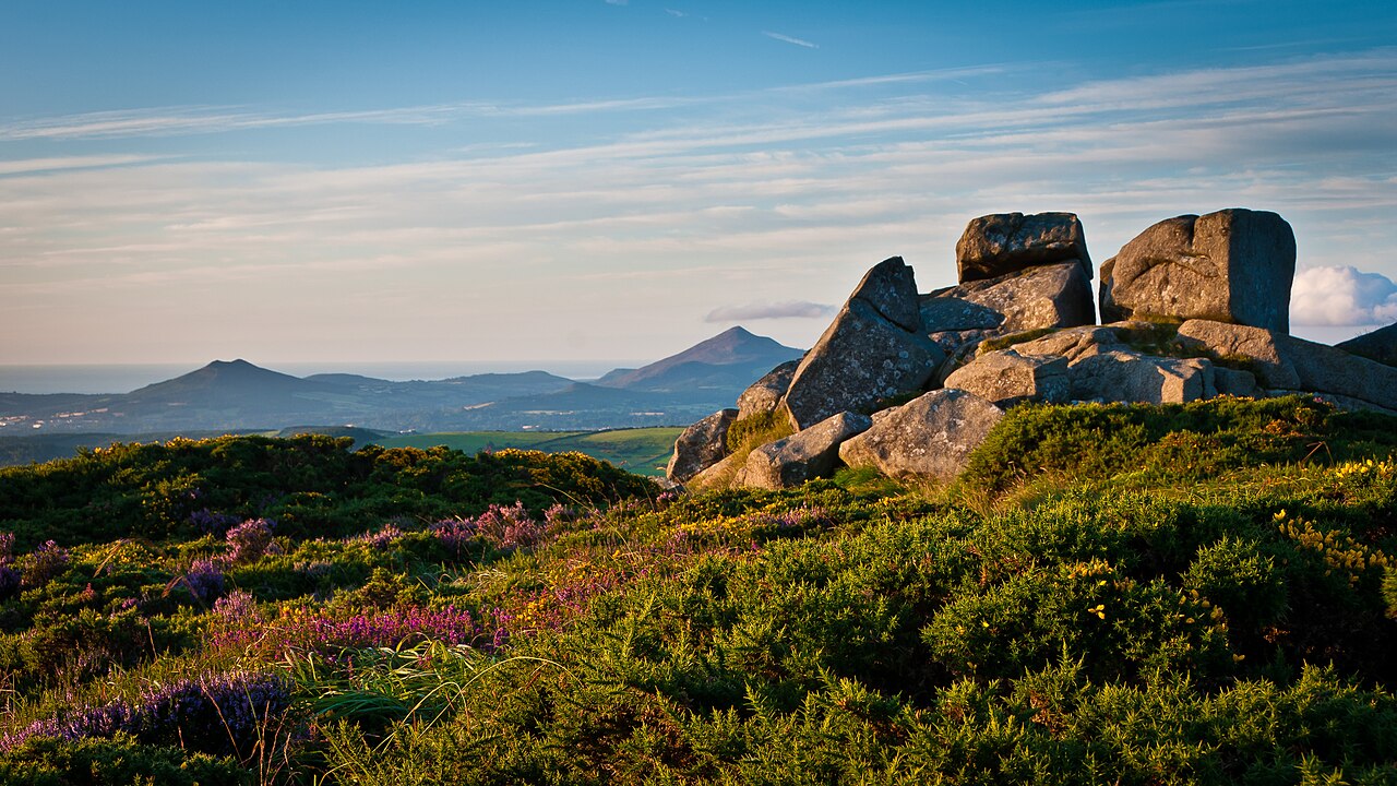
Dublín, el tercer condado más pequeño por superficie, limita al oeste y al norte con Meath , al oeste con Kildare , al sur con Wicklow y al este con el mar de Irlanda . La parte sur del condado está dominada por las montañas de Dublín , que se elevan hasta unos 760 metros (2500 pies) y contienen numerosos valles, embalses y bosques. La costa este del condado está salpicada de varias bahías y ensenadas, entre ellas el estuario de Rogerstown , el estuario de Broadmeadow , la bahía de Baldoyle y, sobre todo, la bahía de Dublín . La sección norte del condado, hoy conocida como Fingal , varía enormemente en carácter, desde pueblos suburbanos densamente poblados del cinturón de cercanías de la ciudad hasta llanuras planas y fértiles, que son algunos de los centros agrícolas y hortícolas más grandes del país.
Dublín es el condado más antiguo de Irlanda y fue la primera parte de la isla en ser dividida en condados tras la invasión normanda a finales del siglo XII. Si bien ya no es un área de gobierno local, Dublín conserva una identidad fuerte y se sigue haciendo referencia a él como región y condado indistintamente, incluso a nivel de organismos gubernamentales. [7] [8]

El condado de Dublín debe su nombre a la ciudad de Dublín, que es una anglicización de su antiguo nombre nórdico Dyflin . La ciudad fue fundada en el siglo IX d. C. por colonos vikingos que establecieron el Reino de Dublín . El asentamiento vikingo fue precedido por un sitio eclesiástico cristiano conocido como Duiblinn , del que Dyflin tomó su nombre. Duiblinn deriva del irlandés clásico temprano Dubhlind / Duibhlind , de dubh ( IPA: [d̪uβ] , IPA: [d̪uw] , IPA: [d̪uː] ) que significa 'negro, oscuro', y lind ( IPA: [lʲiɲ(d̪ʲ)] ) 'piscina', en referencia a una piscina de marea oscura. Esta piscina de marea estaba ubicada donde el río Poddle ingresaba al Liffey , en la parte trasera del Castillo de Dublín .
El interior de Dublín en el período nórdico se llamaba en nórdico antiguo : Dyflinnar skíði , lit. 'Dublinshire'. [9] : 24
Además de Dyflin , un asentamiento gaélico conocido como Áth Cliath ('vado de vallas') [10] se encontraba más arriba del río Liffey, cerca del actual puente Father Mathew . Baile Átha Cliath significa 'ciudad del vado de vallas', y Áth Cliath hace referencia a un punto de vadeo a lo largo del río. Al igual que con Duiblinn , también se encontraba un monasterio cristiano primitivo en Áth Cliath , en el sitio que actualmente ocupa la iglesia carmelita de Whitefriar Street .
Dublín fue el primer condado de Irlanda en ser nombrado condado después de la conquista normanda a finales del siglo XII. Los normandos arrebataron el Reino de Dublín a sus gobernantes nórdico-gaélicos y el nombre se utilizó como base para el nombre oficial anglonormando (y más tarde inglés ) del condado. Sin embargo, en irlandés moderno la región recibió el nombre del asentamiento gaélico de Baile Átha Cliath o simplemente Áth Cliath . Como resultado, Dublín es uno de los cuatro condados de Irlanda con un origen de nombre diferente tanto para el irlandés como para el inglés; los otros son Wexford , Waterford y Wicklow , cuyos nombres en inglés también se derivan del nórdico antiguo.

Los primeros habitantes registrados del actual Dublín se asentaron a lo largo de la desembocadura del río Liffey . En 2007 se descubrieron los restos de cinco trampas de madera para peces cerca de Spencer Dock. Estas trampas estaban diseñadas para atrapar peces que llegaban durante la marea alta y podían recuperarse durante la marea baja. Se utilizaron hachas de piedra de hoja fina para fabricar las trampas y la datación por radiocarbono las sitúa en el período Mesolítico tardío ( c. 6100-5700 a. C.). [11]
Los vikingos invadieron la región a mediados del siglo IX d. C. y fundaron lo que se convertiría en la ciudad de Dublín. Con el tiempo se mezclaron con los nativos de la zona, convirtiéndose en nórdicos-gaélicos . Los vikingos invadieron Irlanda, Gran Bretaña, Francia y España durante este período y bajo su gobierno Dublín se convirtió en el mercado de esclavos más grande de Europa occidental . [12] Si bien los vikingos eran formidables en el mar, la superioridad de las fuerzas terrestres irlandesas pronto se hizo evidente, y los gobernantes nórdicos del reino fueron exiliados por primera vez de la región ya en 902. Dublín fue capturada por el Gran Rey de Irlanda , Máel Sechnaill II , en 980, quien liberó a los esclavos gaélicos del reino. [13] Dublín fue nuevamente derrotado por Máel Sechnaill en 988 y obligado a aceptar la ley Brehon y pagar impuestos al Gran Rey. [14] Las derrotas sucesivas a manos de Brian Boru en 999 y, la más famosa, en la batalla de Clontarf en 1014, relegaron a Dublín a la categoría de reino menor.

En 1170, el derrocado rey de Leinster , Diarmait Mac Murchada , y sus aliados normandos acordaron capturar Dublín en un consejo de guerra en Waterford . Eludieron al ejército interceptor del Gran Rey Ruaidrí Ua Conchobair marchando a través de las montañas de Wicklow , llegando fuera de las murallas de Dublín a fines de septiembre. [15] El rey de Dublín, Ascall mac Ragnaill , se reunió con Mac Murchada para negociar; sin embargo, mientras las conversaciones estaban en curso, los normandos, liderados por de Cogan y FitzGerald , asaltaron Dublín y abrumaron a sus defensores, obligando a mac Ragnaill a huir a las Islas del Norte . [16] Intentos separados de recuperar Dublín fueron lanzados por Ua Conchobair y mac Ragnaill en 1171, los cuales fueron infructuosos.
La autoridad sobre Irlanda establecida por el rey anglonormando Enrique II se fue perdiendo gradualmente durante el resurgimiento gaélico a partir del siglo XIII. El poder inglés disminuyó de manera tan significativa que a principios del siglo XVI las leyes y costumbres inglesas se limitaron a una pequeña zona alrededor de Dublín conocida como " The Pale ". La rebelión fallida del conde de Kildare en 1535 reavivó el interés de los Tudor en Irlanda, y Enrique VIII proclamó el Reino de Irlanda en 1542, con Dublín como su capital. Durante los siguientes 60 años, la conquista Tudor se extendió a todos los rincones de la isla, que fue totalmente sometida en 1603 .
A pesar de las duras leyes penales y las restricciones comerciales desfavorables impuestas a Irlanda, Dublín floreció en el siglo XVIII. Los edificios georgianos que todavía definen gran parte del paisaje arquitectónico de Dublín hasta el día de hoy se construyeron en su mayoría durante un período de 50 años que abarca desde aproximadamente 1750 hasta 1800. Organismos como la Comisión de Calles Anchas remodelaron completamente la ciudad, demoliendo la mayor parte del Dublín medieval en el proceso. [17] Durante la Ilustración , las leyes penales fueron derogadas gradualmente y los miembros de la Ascendencia Protestante comenzaron a considerarse ciudadanos de una nación irlandesa distinta. [18] El Partido Patriota Irlandés , liderado por Henry Grattan , agitó por una mayor autonomía de Gran Bretaña , que se logró bajo la Constitución de 1782. Estas libertades resultaron efímeras, ya que el Parlamento irlandés fue abolido bajo las Leyes de Unión de 1800 e Irlanda se incorporó al Reino Unido . Dublín perdió su estatus político como capital y entró en un marcado declive a lo largo del siglo XIX, lo que dio lugar a demandas generalizadas para revocar la unión . [19]
Aunque en un tiempo fue la segunda ciudad del Imperio Británico , [20] a finales del siglo XIX Dublín era una de las ciudades más pobres de Europa. La ciudad tenía las peores condiciones de vivienda de cualquier parte del Reino Unido , y el hacinamiento, las enfermedades y la desnutrición eran moneda corriente en el centro de Dublín. En 1901, The Irish Times informó que las tasas de enfermedad y mortalidad en Calcuta durante el brote de peste bubónica de 1897 se comparaban "favorablemente con las de Dublín en el momento actual". [21] La mayoría de los residentes de clase alta y media de Dublín se habían mudado a suburbios más ricos, y las grandes casas georgianas del siglo XVIII se convirtieron en masa en barrios marginales de viviendas de una habitación . En 1911, más de 20.000 familias de Dublín vivían en viviendas de una habitación que alquilaban a terratenientes ricos. [22] La calle Henrietta era particularmente famosa por la densidad de sus viviendas: en 1911 vivían en ella 845 personas, incluidas 19 familias (un total de 109 personas) que vivían en una sola casa. [23]

Tras décadas de agitación política, Irlanda parecía estar al borde de una guerra civil como resultado de la Crisis del Autogobierno . A pesar de ser el centro del unionismo irlandés fuera del Ulster , Dublín estaba abrumadoramente a favor del autogobierno. Los partidos unionistas habían tenido un desempeño pobre en el condado desde la década de 1870, lo que llevó al historiador contemporáneo WEH Lecky a concluir que "el unionismo del Ulster es la única forma de unionismo irlandés que es probable que cuente como una fuerza política seria". [24] A diferencia de sus contrapartes en el norte, los "unionistas del sur" eran una clara minoría en el resto de Irlanda y, como tales, estaban mucho más dispuestos a cooperar con el Partido Parlamentario Irlandés (IPP) para evitar la partición . Después del Tratado Anglo-Irlandés , el unionista de Belfast Dawson Bates condenó las "efusivas profesiones de lealtad y confianza en el Gobierno Provisional" que mostraron los ex unionistas en el nuevo Estado Libre Irlandés . [25]
La cuestión del autogobierno local quedó en suspenso debido al estallido de la Primera Guerra Mundial , pero nunca se volvió a tratar debido a una serie de errores del gobierno británico, como la ejecución de los líderes del Levantamiento de Pascua de 1916 y la Crisis del Reclutamiento de 1918 , que alimentaron el período revolucionario irlandés . El IPP casi fue aniquilado por el Sinn Féin en las elecciones generales de 1918 y, después de una breve guerra de independencia , 26 de los 32 condados de Irlanda se separaron del Reino Unido en diciembre de 1922, y Dublín se convirtió en la capital del Estado Libre Irlandés y, más tarde, de la República de Irlanda. [26]
A partir de la década de 1960, la ciudad de Dublín se expandió enormemente debido a las obras de renovación urbana y la construcción de grandes suburbios como Tallaght , Coolock y Ballymun , que reasentaron a los pobres rurales y urbanos del condado de Dublín en alojamientos más nuevos construidos por el estado. [27] Dublín fue la fuerza impulsora detrás del período del Tigre Celta de Irlanda , una era de rápido crecimiento económico que comenzó a principios de la década de 1990. En marcado contraste con el cambio de siglo XX, Dublín entró en el siglo XXI como una de las ciudades más ricas de Europa, atrayendo inmigrantes e inversiones de todo el mundo. [28]

Dublín es el tercer condado más pequeño de los 32 que tiene Irlanda en cuanto a superficie y el más grande en términos de población. Es el tercero más pequeño de los 12 condados de Leinster en cuanto a tamaño y el más grande en términos de población. Dublín comparte frontera con tres condados: Meath al norte y al oeste, Kildare al oeste y Wicklow al sur. Al este, Dublín tiene una costa en el mar de Irlanda que se extiende por 155 kilómetros (96 millas). [29] [30]
Dublín es una región topográficamente variada. El centro de la ciudad es generalmente muy bajo y muchas áreas de la costa de Dublín están al nivel del mar o cerca de él. En el sur del condado, la topografía se eleva abruptamente desde el nivel del mar en la costa hasta más de 500 metros (1600 pies) en solo unos pocos kilómetros. Esta barrera natural ha dado lugar a asentamientos costeros densamente poblados en Dún Laoghaire-Rathdown y una expansión urbana hacia el oeste en el sur de Dublín . En contraste, Fingal es generalmente de naturaleza rural y mucho menos densamente poblada que el resto del condado. En consecuencia, Fingal es significativamente más grande que las otras tres autoridades locales y cubre aproximadamente el 49,5% de la superficie terrestre del condado de Dublín. Fingal es también quizás la región más plana de Irlanda, con las bajas colinas de Naul que se elevan a una altura máxima de solo 176 metros (577 pies). [31]
Dublín está delimitada al sur por las montañas de Wicklow . Allí donde las montañas se extienden hacia el condado de Dublín, se las conoce localmente como las montañas de Dublín ( Sléibhte Bhaile Átha Cliath ). Kippure , en la frontera entre Dublín y Wicklow, es la montaña más alta del condado, a 757 metros (2484 pies) sobre el nivel del mar. Atravesadas por la ruta Dublin Mountains Way , son una zona de recreo popular, con Two Rock , Three Rock , Tibradden , Ticknock , Montpelier Hill y Glenasmole entre los destinos de senderismo más transitados de Irlanda. La cubierta forestal se extiende a más de 6000 hectáreas (15 000 acres) dentro del condado, casi todas las cuales se encuentran en las montañas de Dublín. Con solo el 6,5% de Dublín bajo bosque, es el sexto condado menos boscoso de Irlanda. [32]
Gran parte del condado está drenado por sus tres ríos principales: el río Liffey , el río Tolka en el norte de Dublín y el río Dodder en el sur de Dublín. El Liffey, con 132 kilómetros (82 millas) de longitud, es el octavo río más largo de Irlanda y nace cerca de Tonduff en el condado de Wicklow, llegando al mar de Irlanda en los Docklands de Dublín . El Liffey atraviesa el centro de la ciudad de Dublín, y la división resultante entre el lado norte y el lado sur es una distinción social, económica y lingüística de uso frecuente. Las entradas notables incluyen la bahía central de Dublín , el estuario de Rogerstown , el estuario de Broadmeadow y la bahía de Killiney, bajo la colina de Killiney . Los promontorios incluyen Howth Head , Drumanagh y la costa de Portraine. [33] En términos de biodiversidad , estas regiones estuarinas y costeras albergan una gran cantidad de áreas de importancia ecológica. El condado de Dublín contiene 11 áreas especiales de conservación (ZEC) y 11 áreas de protección especial (ZEPA) designadas por la UE . [34]
La geología del lecho rocoso de Dublín consiste principalmente en caliza del Carbonífero Inferior , que subyace a aproximadamente dos tercios de todo el condado, extendiéndose desde Skerries hasta Booterstown . Durante el Carbonífero Inferior (aproximadamente 340 millones de años), el área era parte de un mar tropical cálido habitado por una abundancia de corales , crinoideos y braquiópodos . Las rocas más antiguas de Dublín son las pizarras cámbricas ubicadas en Howth Head, que se depositaron hace aproximadamente 500 millones de años. La interrupción que siguió al cierre del océano de Jápeto hace aproximadamente 400 millones de años resultó en la formación de granito . [35] Esto ahora está expuesto en la superficie desde las montañas de Dublín hasta las áreas costeras de Dún Laoghaire. La extracción y fundición de plomo del siglo XIX en las minas de plomo de Ballycorus causó un envenenamiento generalizado por plomo , y el área alguna vez fue apodada "Valle de la Muerte". [36]


.jpg/1280px-Snow_in_Killiney,_Dublin_(2010).jpg)
Según la clasificación climática de Köppen , Dublín se encuentra en una región oceánica templada marítima . Su clima se caracteriza por inviernos fríos, veranos suaves y húmedos y ausencia de temperaturas extremas. Met Éireann tiene varias estaciones meteorológicas en el condado, con dos estaciones principales en el aeropuerto de Dublín y el aeródromo de Casement .
Las temperaturas anuales suelen estar dentro de un rango estrecho. En Merrion Square , el mes más frío es febrero, con una temperatura mínima promedio de 4,1 °C (39,4 °F), y el mes más cálido es julio, con una temperatura máxima promedio de 20,1 °C (68,2 °F). Debido al efecto de isla de calor urbana , la ciudad de Dublín tiene las noches de verano más cálidas de Irlanda. La temperatura mínima promedio en Merrion Square en julio es de 13,5 °C (56,3 °F), similar a Londres y Berlín , y la temperatura más baja de julio jamás registrada en la estación fue de 7,8 °C (46,0 °F) el 3 de julio de 1974. [37] [38] En el aeropuerto de Dublín, el mes más seco es febrero con 48,8 mm (2 pulgadas) de lluvia, y el mes más húmedo es noviembre, con 79,0 mm (3 pulgadas) de lluvia en promedio.
Como la dirección predominante del viento en Irlanda es del sur y del oeste, las montañas de Wicklow crean una sombra de lluvia sobre gran parte del condado. La ubicación protegida de Dublín lo convierte en el lugar más seco de Irlanda, recibiendo solo aproximadamente la mitad de las precipitaciones de la costa oeste. Ringsend , en el sur de la ciudad de Dublín, registra la precipitación más baja del país, con una precipitación anual promedio de 683 mm (27 pulgadas). La zona más húmeda del condado es el valle de Glenasmole , que recibe 1159 mm (46 pulgadas) de lluvia por año. Como condado costero templado, la nieve es relativamente poco común en las áreas de tierras bajas; sin embargo, Dublín es particularmente vulnerable a fuertes nevadas en raras ocasiones donde los vientos fríos y secos del este dominan durante el invierno. [39]
A finales de verano y principios de otoño, Dublín puede sufrir tormentas atlánticas, que traen fuertes vientos y lluvias torrenciales a Irlanda. Dublín fue el condado más afectado por el huracán Charley en 1986. Causó graves inundaciones, especialmente a lo largo del río Dodder, y se dice que fue la peor inundación en la historia de Dublín. Los récords de precipitaciones se rompieron en todo el condado. Kippure registró 280 mm (11 pulgadas) de lluvia en un período de 24 horas, la mayor precipitación diaria total jamás registrada en Irlanda. El gobierno asignó IR£ 6.449.000 (equivalentes a US$ 20,5 millones en 2020) para reparar los daños causados por Charley. [40] Los dos embalses de Bohernabreena en las montañas de Dublín fueron mejorados en 2006 después de que un estudio sobre el impacto del huracán Charley concluyera que una tormenta ligeramente más grande habría provocado la ruptura de las presas del embalse, lo que habría resultado en daños catastróficos y una pérdida significativa de vidas.
En contraste con la costa atlántica , la costa este de Irlanda tiene relativamente pocas islas. El condado de Dublín tiene una de las mayores concentraciones de islas en la costa este irlandesa. Colt Island, St. Patrick's Island, Shenick Island y numerosos islotes más pequeños se agrupan frente a la costa de Skerries y se conocen colectivamente como el "Área de Patrimonio Natural de las Islas Skerries". Más lejos se encuentra Rockabill , que es la isla más aislada de Dublín, a unos 6 kilómetros (3,7 millas) de la costa. Lambay Island , con 250 hectáreas (620 acres), es la isla más grande frente a la costa este de Irlanda y el punto más oriental del condado de Dublín. Lambay alberga una de las colonias de aves marinas más grandes de Irlanda y, curiosamente, también alberga una población de ualabíes de cuello rojo no nativos . [41] Al sur de Lambay se encuentra una isla más pequeña conocida como Ireland's Eye , el resultado de una traducción errónea del nombre irlandés de la isla por parte de los vikingos invasores .
La isla Bull es una isla artificial que se encuentra aproximadamente paralela a la costa y que comenzó a formarse tras la construcción del Muro Bull en 1825. La isla sigue creciendo y actualmente tiene 5 kilómetros (3,1 millas) de largo y 0,8 kilómetros (0,50 millas) de ancho. En 1981, la isla Bull Norte ( Oileán an Tairbh Thuaidh ) fue designada como reserva de la biosfera por la UNESCO . [42]

.png/1280px-IrelandBaronies1899Map_(Dublin_cropped).png)
A efectos estadísticos a nivel europeo, el condado en su conjunto forma la Región de Dublín, entidad NUTS III , que a su vez forma parte de la Región Oriental y Midland , entidad NUTS II. Cada una de las autoridades locales tiene representantes en la Asamblea Regional Oriental y Midland.
Hay diez baronías históricas en el condado. [43] Si bien las baronías continúan siendo unidades definidas oficialmente, dejaron de tener cualquier función administrativa después de la Ley de Gobierno Local de 1898 , y cualquier cambio en los límites del condado después de mediados del siglo XIX no se refleja en su extensión. El último cambio de límites de una baronía en Dublín fue en 1842, cuando la baronía de Balrothery se dividió en Balrothery East y Balrothery West. La baronía más grande registrada en Dublín en 1872 fue Uppercross, con 39,032 acres (157,96 km 2 ), y la baronía más pequeña fue Dublín, con 1,693 acres (6,85 km 2 ).
Los townlands son las divisiones geográficas definidas oficialmente más pequeñas de Irlanda. Hay 1.090 townlands en Dublín, de los cuales 88 son límites históricos de la ciudad. Estos límites de la ciudad están registrados como sus propios townlands y son mucho más grandes que los townlands rurales. Los townlands rurales más pequeños de Dublín tienen solo 1 acre de tamaño, la mayoría de los cuales son islas costeras ( Clare Rock Island, Lamb Island, Maiden Rock, Muglins, Thulla Island ). El townland rural más grande de Dublín tiene 2.797 acres ( Caastlekelly ). El tamaño promedio de un townland en el condado (excluyendo las ciudades) es de 205 acres.
En virtud de la Ley de Gobierno Local (Irlanda) de 1898 , el condado de Dublín se dividió en los distritos urbanos de Blackrock , Clontarf , Dalkey , Drumcondra, Clonliffe y Glasnevin , Killiney y Ballybrack , Kingstown , New Kilmainham , Pembroke y Rathmines y Rathgar , y los distritos rurales de Balrothery , Celbridge No. 2, North Dublin, Rathdown y South Dublin. [45]
Howth, anteriormente dentro del distrito rural de Dublín Norte, se convirtió en un distrito urbano en 1919. [46] Kingstown pasó a llamarse Dún Laoghaire en 1920. [47] Los distritos rurales fueron abolidos en 1930. [48]
Balbriggan , en el distrito rural de Balrothery, tenía comisionados municipales en virtud de la Ley de Mejora de Ciudades (Irlanda) de 1854. Se convirtió en un consejo municipal en 2002. [49] Al igual que todos los consejos municipales, fue abolido en 2014.
Los distritos urbanos fueron absorbidos gradualmente por la ciudad de Dublín, a excepción de cuatro distritos costeros de Blackrock, Dalkey, Dún Laoghaire y Killiney y Ballybrack, que formaron el distrito de Dún Laoghaire en 1930. [50]

La ciudad de Dublín había sido administrada por separado desde el siglo XIII. En virtud de la Ley de Gobierno Local (Irlanda) de 1898 , las dos áreas se definieron como el condado administrativo de Dublín y el distrito municipal de Dublín, siendo este último parte de la ciudad.
En 1985, el condado de Dublín se dividió en tres condados electorales: Dublín-Belgard al suroeste (Dublín Sur desde 1991), Dublín-Fingal al norte (Fingal desde 1991) y Dún Laoghaire-Rathdown al sureste. [58] [59] [60]
El 1 de enero de 1994, en virtud de la Ley de Gobierno Local (Dublín) de 1993 , el condado de Dublín dejó de existir como área de gobierno local y fue sucedido por los condados de Dún Laoghaire–Rathdown , Fingal y Dublín Sur , cada uno colindante (con pequeños ajustes de límites) con el área del condado electoral correspondiente. [61] [62] Al analizar la legislación, Avril Doyle TD dijo: "El proyecto de ley que tenemos ante nosotros hoy suprime efectivamente el condado de Dublín, y como alguien nacido y criado en estas partes de Irlanda, me parece bastante extraño que en esta Cámara estemos suprimiendo el condado de Dublín. No estoy segura de si los dublineses se dan cuenta de que eso es lo que estamos haciendo hoy, pero en efecto ese es el caso". [63]
Aunque la Comisión Electoral debería, en la medida de lo posible, evitar violar los límites de los condados al recomendar distritos electorales para el Dáil , esto no incluye los límites de una ciudad o el límite entre los tres condados de Dublín. [64] También hay un sheriff designado para el condado de Dublín. [65]
El término "Condado de Dublín" todavía se usa comúnmente. Muchas organizaciones y equipos deportivos continúan organizándose sobre la base del Condado de Dublín. La División de Topónimos del Departamento de Turismo, Cultura, Artes, Gaeltacht, Deportes y Medios de Comunicación mantiene una Base de Datos de Topónimos que registra todos los topónimos, pasados y presentes. [66] El Condado de Dublín está incluido en la base de datos junto con las subdivisiones de ese condado. [67] [68] También se usa como dirección para áreas dentro de Dublín fuera del sistema de distritos postales de Dublín . [69] [70]
Durante un período en 2020, durante la pandemia de COVID-19 , para reducir el contacto entre personas, las regulaciones gubernamentales restringieron la actividad "dentro del condado en el que se encuentra la residencia en cuestión". Según las regulaciones, las áreas de gobierno local de "Dún Laoghaire–Rathdown, Fingal, South Dublin y Dublin City" se consideraron un solo condado (al igual que la ciudad y el condado de Cork, y la ciudad y el condado de Galway). [71]
El último mapa de la región de Dublín, en escala 1:50.000, de la serie Discovery de Ordnance Survey Ireland (tercera edición, 2005), hoja 50, muestra los límites de la ciudad y de los tres condados circundantes de la región. Los extremos de la región de Dublín, al norte y al sur de la región, aparecen en otras hojas de la serie, 43 y 56 respectivamente.

Hay cuatro autoridades locales cuyo ámbito de competencias abarca colectivamente el área geográfica del condado y la ciudad de Dublín: el Ayuntamiento de Dublín , el Ayuntamiento del Condado de Dublín Sur , el Ayuntamiento del Condado de Dún Laoghaire–Rathdown y el Ayuntamiento del Condado de Fingal .
Hasta el 1 de enero de 1994, el condado administrativo de Dublín estuvo administrado por el Consejo del Condado de Dublín . A partir de esa fecha, sus funciones fueron sustituidas por el Consejo del Condado de Dún Laoghaire–Rathdown, el Consejo del Condado de Fingal y el Consejo del Condado de Dublín Sur, cada uno con su sede de condado , que administraban respectivamente los nuevos condados creados en esa fecha. [72]
Anteriormente, la ciudad era un distrito municipal y estaba administrada por la Corporación de Dublín . En virtud de la Ley de Gobierno Local de 2001 , el país se dividió en áreas de gobierno local de ciudades y condados, y el distrito municipal de Dublín fue designado como ciudad para todos los efectos, y ahora está administrado por el Ayuntamiento de Dublín . Cada autoridad local es responsable de ciertos servicios locales , como el saneamiento, la planificación y el desarrollo, las bibliotecas, la recaudación de impuestos sobre vehículos, las carreteras locales y la vivienda social .
Dublín, que comprende las cuatro áreas de gobierno local del condado, es un área de planificación estratégica dentro de la Asamblea Regional del Este y Midland (EMRA). [73] [74] Es una región NUTS de nivel III de Irlanda . La región es una de las ocho regiones de Irlanda para las estadísticas de Eurostat en el nivel NUTS 3. [75] Su código NUTS es IE061.
Esta zona anteriormente estaba bajo la jurisdicción de la Autoridad Regional de Dublín. [76] Esta Autoridad se disolvió en 2014. [77]
.jpeg/1280px-Cityscape_At_Sunset_Dublin_Ireland_Cityscape_Photography_(179394129).jpeg)

Según el censo de 2022 , la población de Dublín era de 1.458.154 habitantes, un aumento del 8,4 % desde el censo de 2016. La población del condado superó por primera vez el millón en 1981 y se proyecta que alcance los 1,8 millones en 2036. [88]
Dublín es el condado más poblado de Irlanda , una posición que ha ocupado desde el censo de 1926, cuando superó al condado de Antrim . En 2022, el condado de Dublín tiene más del doble de población que el condado de Antrim y dos veces y media la población del condado de Cork . Aproximadamente el 21% de la población de Irlanda vive en el condado de Dublín (el 28% si solo se cuenta la República de Irlanda ). Además, Dublín tiene más habitantes que las poblaciones combinadas de los 16 condados más pequeños de Irlanda.
Con una superficie de tan solo 922 km2 ( 356 millas cuadradas), Dublín es, con diferencia, el condado más densamente poblado de Irlanda. La densidad de población del condado es de 1.582 habitantes por kilómetro cuadrado, más de 7 veces superior a la del segundo condado más densamente poblado de Irlanda, el condado de Down, en Irlanda del Norte.
Durante el período del Tigre Celta , un gran número de nativos de Dublín (dublinenses) se trasladaron a las ciudades dormitorio en rápida expansión de los condados adyacentes. En 2022, aproximadamente el 27,2% (345.446) de los dublineses vivían fuera del condado de Dublín. Las personas nacidas en Dublín representan el 28% de la población de Meath , el 32% de Kildare y el 37% de Wicklow . Hay 922.744 nativos de Dublín viviendo dentro del condado, lo que representa el 63,3% de la población. Las personas nacidas en otros condados irlandeses que viven dentro de Dublín representan aproximadamente el 11% de la población. [89]
Entre 2016 y 2022, la migración internacional produjo un aumento neto de 88.300 personas. Dublín tiene la mayor proporción de residentes internacionales de todos los condados de Irlanda, y alrededor del 25 % de la población del condado nació fuera de la República de Irlanda . [90]
Según el censo de 2022, el 5,6 por ciento de la población del condado tenía menos de 5 años, el 25,7 por ciento tenía entre 5 y 25 años, el 55,3 por ciento tenía entre 25 y 65 años y el 13,4 por ciento de la población tenía más de 65 años. De este último grupo, 48.865 personas (3,4 por ciento) tenían más de 80 años, más del doble desde 2016. En todos los grupos de edad, había ligeramente más mujeres (51,06 por ciento) que hombres (48,94 por ciento). [91]
En 2021, hubo 16.596 nacimientos en el condado y la edad promedio de las madres primerizas fue de 31,9 años. [92]

Más de una cuarta parte (25,2 por ciento) de la población del condado de Dublín nació fuera de la República de Irlanda. En 2022, la ciudad de Dublín tenía el porcentaje más alto de no nacionales en el condado (27,3 por ciento), y el sur de Dublín tenía el más bajo (20,9 por ciento). [93] Históricamente, la población inmigrante de Dublín provenía principalmente del Reino Unido y otros estados miembros de la Unión Europea . Sin embargo, los resultados del censo de 2022 revelaron que los inmigrantes de países no pertenecientes a la UE/Reino Unido fueron la mayor fuente de residentes nacidos en el extranjero por primera vez, representando el 12,9 por ciento de la población del condado. Los de otros estados miembros de la Unión Europea representaron el 8,3 por ciento de la población de Dublín, y los del Reino Unido un 4,1 por ciento adicional. [94]
Antes de la década de 2000, el Reino Unido era sistemáticamente la mayor fuente de extranjeros que vivían en Dublín. Tras haber disminuido en los dos censos anteriores, el número de residentes nacidos en el Reino Unido que vivían en Dublín aumentó un 5,8 por ciento entre 2016 y 2022. En el censo de 2022, había una gran diferencia entre el número de personas que vivían en Dublín que habían nacido en el Reino Unido (58.586) y las que tenían ciudadanía exclusivamente británica (22.936). Esta discrepancia puede deberse a diversos factores, como el hecho de que las personas nacidas en Irlanda del Norte reclamen la ciudadanía irlandesa en lugar de la británica, los irlandeses nacidos en el Reino Unido que ahora viven en Dublín, los británicos que se han convertido en ciudadanos naturales y los residentes extranjeros de Dublín que nacieron en el Reino Unido pero no son ciudadanos británicos. Según las respuestas de una persona en el censo, todos estos ejemplos podrían dar lugar a que la Oficina de Estadísticas Civiles registre el país de nacimiento como el Reino Unido, pero la nacionalidad como irlandesa o de un tercer país.
Tras su adhesión a la UE , los polacos se convirtieron rápidamente en la comunidad inmigrante de más rápido crecimiento en Dublín. En 1999, tan solo 188 polacos solicitaron permisos de trabajo irlandeses. En 2006, esta cifra había aumentado a 93.787. [95] Tras la crisis económica irlandesa de 2008 , hasta 3.000 polacos abandonaron Irlanda cada mes. A pesar de ello, los polacos siguen siendo uno de los mayores grupos de inmigrantes nacidos en el extranjero de Dublín. A diferencia de los recién llegados, un gran porcentaje de los ciudadanos polacos de Dublín (30,9 por ciento) también tienen ciudadanía irlandesa.
Fuera de Europa, los indios y los brasileños son los grupos de extranjeros predominantes. En 2022, los indios fueron el grupo de inmigrantes más importante de más rápido crecimiento en Dublín, y ahora son el segundo grupo nacido en el extranjero más grande del condado después del Reino Unido. La comunidad india de Dublín creció un 155,2 por ciento entre 2016 y 2022. Había 29.582 residentes nacidos en la India en Dublín en 2022, frente a los 9.884 del censo de 2011. [ 97] La afluencia de indios está impulsada en parte por empresas tecnológicas multinacionales como Microsoft , Google y Meta , que han ubicado sus sedes europeas dentro del condado, en áreas como Silicon Docks y Sandyford . En agosto de 2020, se construyó el primer templo hindú dedicado en Irlanda en Walkinstown . [98]
El número de ciudadanos brasileños que viven en Dublín se triplicó entre 2011 y 2022, pasando de 4.641 a 16.441. Este aumento se debe principalmente a la participación de Irlanda en el programa Ciência sem Fronteiras del gobierno brasileño , que atrae a miles de estudiantes brasileños a estudiar a Irlanda cada año, muchos de los cuales permanecen en el país después de estudiar. [99]
Aunque no se registró la totalidad de los datos durante el período del censo, Dublín también alberga a un número significativo de refugiados ucranianos en virtud de la Directiva de Protección Temporal . A partir de octubre de 2023, se estima que el número de ucranianos que viven en alojamientos de emergencia dentro del condado es de alrededor de 14.000. [100]
Según la Oficina Central de Estadísticas, en 2022 la población del condado de Dublín se autoidentificó como:
Por etnia, en 2022 la población era 80,4% blanca. Aquellos que se identificaron como irlandeses blancos constituían el 68,0% de la población del condado, y los nómadas irlandeses representaban otro 0,4%. Los caucásicos que no se identificaron como étnicamente irlandeses representaban el 12,0% de la población.
En términos de números totales, Dublín tiene la población no blanca más grande de Irlanda, con un estimado de 158.653 residentes, lo que representa el 11,1% de la población del condado. Más de dos quintas partes (42,2 por ciento) de los residentes negros de Irlanda viven dentro del condado. En términos de porcentaje de población, Fingal tiene el porcentaje más alto de residentes negros (3,6 por ciento) y no blancos (12,4 por ciento) de cualquier autoridad local en Irlanda. Por el contrario, Dún Laoghaire–Rathdown en el sur del condado tiene uno de los porcentajes más bajos de residentes negros de Irlanda, con solo el 0,77% de la población que se identifica como negra en 2022. Además, el 43,3% de la población multirracial de Irlanda vive en el condado de Dublín. Aquellos que no declararon su origen étnico aumentaron más del doble entre 2016 y 2022, del 4,1% al 8,5%. [101] [102]
.jpg/1280px-St_Patrick's_Cathedral,_Dublin_(40282975540).jpg)
La denominación religiosa más grande , tanto por número de fieles como por porcentaje de la población de Dublín en 2022, fue la Iglesia católica romana, con un 57,4 por ciento. Todas las demás denominaciones cristianas, incluidas la Iglesia de Irlanda , la Iglesia ortodoxa oriental , la Iglesia presbiteriana y la Iglesia metodista, representaron el 8,1 por ciento de la población de Dublín. En conjunto, todas las denominaciones del cristianismo representaron el 65,5 por ciento de la población del condado. Según el censo de 2022, Dún Laoghaire–Rathdown es la autoridad local menos religiosa de Irlanda, con un 23,9 por ciento de la población que se declara no religiosa, seguida de cerca por la ciudad de Dublín (22,6 por ciento). En el condado en su conjunto, los que no están afiliados a ninguna religión representaron el 20,1 por ciento de la población, que es el mayor porcentaje de personas no religiosas de cualquier condado de Irlanda. Otro 9,1 por ciento de la población no declaró su religión, frente a solo el 4,1 por ciento en 2016.
De las religiones no cristianas, el islam es la más numerosa en cuanto a número de fieles, ya que los musulmanes representan el 2,6% de la población. Después del islam, las religiones no cristianas más numerosas en 2022 fueron el hinduismo (1,4%) y el budismo (0,27%). Aunque es relativamente pequeño en términos absolutos, el condado de Dublín alberga más de la mitad de los residentes hindúes de Irlanda (58,7%) y poco menos de la mitad de sus residentes ortodoxos orientales (45,3%), islámicos (45,0%) y budistas (41,7%). [103]
Dublín y su interior han sido una diócesis cristiana desde 1028. Durante siglos, la Primacía de Irlanda fue disputada entre Dublín, la capital social y política de Irlanda, y Armagh , sitio de la iglesia principal de San Patricio , que fue fundada en 445 d. C. En 1353, la disputa fue resuelta por el Papa Inocencio VI , quien proclamó que el arzobispo de Dublín era Primado de Irlanda , mientras que el arzobispo de Armagh era titulado Primado de toda Irlanda . Estos dos títulos distintos se replicaron en la Iglesia de Irlanda después de la Reforma . Históricamente, el condado de Dublín fue el epicentro del protestantismo en Irlanda fuera del Ulster . Los registros del censo de 1891 muestran que el condado era 21,4 por ciento protestante hacia fines del siglo XIX. Para el censo de 1911, esto había disminuido gradualmente a alrededor del 20% debido a las malas condiciones económicas, ya que los protestantes de Dublín se mudaron a la industrial Belfast . Después de la Guerra de la Independencia (1919-1921), la comunidad protestante de Dublín entró en un declive constante, cayendo al 8,5 por ciento de la población en 1936. [104]
Entre 2016 y 2022, las religiones de más rápido crecimiento en Dublín fueron el hinduismo (148,9 por ciento), la ortodoxia oriental (51,6 por ciento) y el islam (27,9 por ciento), mientras que las religiones que declinaron más rápidamente fueron el evangelismo (−10,4 por ciento), el catolicismo (−8,7 por ciento), los testigos de Jehová (−5,9 por ciento) y el budismo (−5,4 por ciento).
Los límites del Ayuntamiento de Dublín forman el núcleo urbano de la ciudad, a menudo denominado "centro de la ciudad de Dublín", un área de 117,8 kilómetros cuadrados. Esto abarca los suburbios centrales de la ciudad, que se extienden hasta Terenure y Donnybrook al sur; Ballymun y Donaghmede al norte ; y Ballyfermot al oeste . En 2022, había 592.713 personas viviendo en el centro de la ciudad de Dublín. Sin embargo, como el área edificada continua se extiende más allá de los límites de la ciudad, el término "ciudad y suburbios de Dublín" se emplea comúnmente para referirse a la extensión real de Dublín.

La ciudad de Dublín y sus suburbios es un área urbana designada por la CSO que incluye el área edificada contigua densamente poblada que rodea el centro de la ciudad de Dublín. Según el censo de 2022, la ciudad de Dublín y sus suburbios abarcaban 345 km2 , expandiéndose en tamaño en un 8,7 por ciento (o 27,5 km2 ) desde el censo de 2016. La población de la ciudad de Dublín y sus suburbios creció de 1.173.179 en 2016 a 1.263.219 en 2022, un aumento del 7,7 por ciento. [105]
Tras el censo de 2022, la ciudad de Dublín y sus suburbios fueron designados asentamiento transcondado por primera vez, ya que la CSO incluyó el complejo de viviendas Kribensis Manor dentro del área edificada contigua de la ciudad. Las casas están ubicadas en el condado de Meath, a lo largo de la carretera R149 entre Hilltown y el pueblo de Clonee .
Según el censo de 2022, aproximadamente el 87 % de la población del condado de Dublín vive en la ciudad y sus suburbios. El resto del condado cubre aproximadamente dos tercios de la superficie de Dublín, pero alberga a solo 196 140 personas. [106]
Como la ciudad propiamente dicha no se extiende más allá del aeropuerto de Dublín , las ciudades cercanas como Swords, Donabate, Portmarnock y Malahide no se consideran parte de la ciudad y la CSO las registra como asentamientos separados. Sin embargo, según el Marco de Planificación Nacional de Irlanda, estas ciudades se consideran parte del Plan Estratégico del Área Metropolitana de Dublín (MASP). [107] El MASP también incluye ciudades fuera del condado, como Naas , Leixlip y Maynooth en el condado de Kildare, Dunboyne en el condado de Meath y Bray , Kilmacanogue y Greystones en el condado de Wicklow, pero no incluye Balbriggan, Lusk, Rush o Skerries, que se encuentran en el extremo norte del condado de Dublín. [108]
El Área Metropolitana de Dublín (GDA) es una jurisdicción de planificación de uso común que se extiende a la red más amplia de ciudades dormitorio que están conectadas económicamente con la ciudad de Dublín. La GDA está formada por el condado de Dublín y sus tres condados vecinos, Kildare , Meath y Wicklow . [109]
Con una población de 2,1 millones y una superficie de 6.986 kilómetros cuadrados, contiene el 40% de la población del Estado y cubre el 9,9% de su superficie terrestre.
Según la clasificación de la CSO , una "zona urbana" es una ciudad con una población superior a 1500 habitantes. Dublín es el condado más urbanizado de Irlanda, con el 98 % de sus residentes residiendo en áreas urbanas en 2022. De las tres autoridades locales no urbanas de Dublín, Fingal tiene la mayor proporción de personas que viven en áreas rurales (7,9 %), mientras que Dún Laoghaire–Rathdown tiene la menor (1,19 %). Los suburbios occidentales de la ciudad de Dublín, como Tallaght y Blanchardstown, han experimentado un rápido crecimiento en las últimas décadas, y ambas áreas tienen una población aproximadamente equivalente a la ciudad de Galway .
.png/1280px-M50_motorway_(Ireland).png)

El condado de Dublín cuenta con la infraestructura de transporte más antigua y extensa de Irlanda. El ferrocarril de Dublín y Kingstown , inaugurado en diciembre de 1834, fue la primera línea ferroviaria de Irlanda. La línea, que iba desde Westland Row hasta Dún Laoghaire , estaba destinada originalmente a ser utilizada para el transporte de mercancías. Sin embargo, resultó mucho más popular entre los pasajeros y se convirtió en la primera línea ferroviaria de cercanías del mundo. [112] La línea se ha modernizado varias veces a lo largo de su historia y todavía se utiliza hasta el día de hoy, lo que la convierte en la ruta ferroviaria de cercanías más antigua del mundo.

El transporte público en Dublín estuvo a cargo de la Oficina de Transporte de Dublín hasta 2009, cuando fue reemplazada por la Autoridad Nacional de Transporte (NTA). Los tres pilares que actualmente sustentan la red de transporte público del Área Metropolitana de Dublín (GDA) son el Ferrocarril Suburbano de Dublín , el Luas y el sistema de autobuses. Hay seis líneas de cercanías en Dublín, que son administradas por Iarnród Éireann . Cinco de estas líneas sirven como rutas entre Dublín y ciudades a lo largo del GDA y más allá. La sexta ruta, conocida como Dublin Area Rapid Transit (DART), está electrificada y sirve solo a Dublín y al norte de Wicklow. La última incorporación a la red de transporte público de Dublín es un sistema de tranvía llamado Luas. El servicio comenzó con dos líneas desconectadas en 2004, [113] con tres extensiones abiertas en 2009, [114] 2010 [115] y 2011 [116] antes de que se abriera un enlace entre ciudades entre las líneas y una extensión adicional en 2017. [117]
Históricamente, Dublín contaba con un extenso sistema de tranvías que comenzó a funcionar en 1871 y en su apogeo llegó a tener más de 97 km (60 mi) de líneas activas. Lo operaba la Dublin United Transport Company (DUTC) y era muy avanzado para su época, con una electrificación casi total a partir de 1901. A partir de la década de 1920, la DUTC comenzó a adquirir operadores de autobuses privados y cerró gradualmente algunas de sus líneas. Las posteriores disminuciones en el número de pasajeros se debieron en parte a la creencia en ese momento de que los tranvías estaban obsoletos y eran arcaicos. Todas las líneas de tranvía terminaron en 1949, excepto el tranvía a Howth , que funcionó hasta 1959.

Dublin Bus es el mayor operador de autobuses del condado, con 138 millones de pasajeros transportados en 2019. [118] En gran parte de la ciudad, en particular en el oeste de Dublín, el autobús es la única opción de transporte público disponible, y hay numerosas empresas de autobuses privadas más pequeñas en funcionamiento en todo el condado de Dublín. El operador nacional de autobuses Bus Éireann ofrece rutas de larga distancia a pueblos y ciudades ubicados fuera de la ciudad de Dublín y su interior inmediato.
En noviembre de 2005, el gobierno anunció una iniciativa de 34 mil millones de euros llamada Transport 21 que incluía una expansión sustancial de la red de transporte de Dublín. El proyecto se canceló en mayo de 2011 a raíz de la recesión de 2008. En consecuencia, en 2017 Hugh Creegan, subdirector de la NTA, declaró que había habido una " subinversión crónica en el transporte público durante más de una década ". [119] En 2019, se informó que Dublín era la decimoséptima ciudad más congestionada del mundo y tenía el quinto tiempo promedio de viaje más alto en la Unión Europea. [120] [121] La red ferroviaria y Luas experimenta regularmente un hacinamiento significativo y retrasos durante las horas pico, y en 2019 Iarnród Éireann fue ampliamente ridiculizado por pedir a los viajeros que " escalonen los viajes matutinos " para aliviar el problema. [122]
La M50 es una autopista de circunvalación de 45,5 km (28,3 mi) que rodea la ciudad de Dublín y es la autopista más transitada del país. Sirve como centro de la red de autopistas tanto de Dublín como de Irlanda, y la mayoría de las carreteras principales nacionales a otras ciudades comienzan en la M50 y se irradian hacia el exterior. La ruta actual se construyó en varias secciones a lo largo de 27 años, desde 1983 hasta 2010. Todas las carreteras principales de Irlanda están administradas por Transport Infrastructure Ireland (TII), que tiene su sede en Parkgate Street, Dublín 8. En 2019, había más de 550.000 automóviles registrados en el condado de Dublín, lo que representa el 25,3% de todos los automóviles registrados en el estado. [123] Debido a la pequeña superficie del condado y al alto grado de urbanización, existe una preferencia por los automóviles usados registrados "D" en toda Irlanda, ya que se considera que han sufrido menos desgaste. [124]
En el caso de los viajes internacionales, alrededor de 1,7 millones de pasajeros viajan en ferry a través del puerto de Dublín cada año. [125] Anteriormente, Stena Line operaba un ferry de Dún Laoghaire a Holyhead , pero la ruta se cerró en 2015. El aeropuerto de Dublín es el aeropuerto más grande de Irlanda y 32,9 millones de pasajeros pasaron por él en 2019, lo que lo convierte en el duodécimo aeropuerto más transitado de Europa. [126]
.png/1280px-Share_of_Irish_GDP_by_Region_(2018).png)
The Dublin Region, which is conterminous with County Dublin, has the largest and most highly developed economy in Ireland, accounting for over two-fifths of national Gross Domestic Product (GDP). The Central Statistics Office estimates that the GDP of the Dublin Region in 2020 was €157.2 billion ($187 billion / £141 billion at 2020 exchange rates).[127] In nominal terms, Dublin's economy is larger than roughly 140 sovereign states. The county's GDP per capita is €107,808 ($117,688 / £92,620), one of the highest regional GDPs per capita in the EU. As of 2019, Dublin also had the highest Human Development Index in Ireland at 0.965, placing it among the most developed places in the world in terms of life expectancy, education and per capita income.[128]

In 2020, average disposable income per person in Dublin was €27,686, or 118% of the national average (€23,400), the highest of any county in Ireland.[129] As Ireland's most populous county, Dublin has the highest total household income in the country, at an estimated €46.8 billion in 2017 – higher than the Border, Midlands, West and South-East regions combined. Dublin residents were the highest per capita tax contributors in the State, returning a total of €15.1 billion in taxes in 2017.[130]
Many of Ireland's most prominent political, educational, cultural and media centres are concentrated south of the River Liffey in Dublin city. Further south, areas like Dún Laoghaire, Dalkey and Killiney have long been some of Dublin's most affluent areas, and Dún Laoghaire–Rathdown consistently has the highest average house prices in Ireland. This has resulted in a perceived socio-economic divide in Dublin, between the generally less affluent Northside and the wealthier Southside. In Dublin (both city and county), residents will commonly refer to themselves as a "Northsider" or a "Southsider", and the division is often caricatured in Irish comedy, media and literature, for example Ross O'Carroll-Kelly and Damo and Ivor.[131] References to the divide have also become colloquialisms in their own right, such as "D4" (referring to the Dublin 4 postal district), which is a pejorative term for an upper middle class Irish person.[132]
While the northside-southside divide remains prevalent in popular culture, economic indices such as the Pobal HP deprivation index have shown that the distinction does not reflect economic reality. Many of Dublin's most affluent areas (Clontarf, Raheny, Howth, Portmarnock, Malahide) are located in the north of the county, and many of its most deprived areas (Jobstown, Ballyogan, Ballybrack, Dolphin's Barn, Clondalkin) are located in the south of the county.
Utilising CSO data from the past three censuses, Pobal HP revealed that there was a much higher concentration of below average, disadvantaged and very disadvantaged areas in west Dublin.[133] In 2012, Irish Times columnist Fintan O'Toole posited that the real economic divide in Dublin was not north–south, but east–west – between the older coastal areas of eastern Dublin and the newer sprawling suburbs of western Dublin – and that the perpetuation of the northside–southside "myth" was a convenient way to gloss over class division within the county. O'Toole argued that framing the city's wealth divide as a light-hearted north–south stereotype was easier than having to address the socio-economic impacts of deliberate government policy to remove working-class people from the city centre and settle them on the margins.[134]

Dublin is both a European and Global financial hub, and around 200 of the world's leading financial services firms have operations within the county. In 2017 and 2018 respectively, Dublin was ranked 5th in Europe and 31st globally in the Global Financial Centres Index (GFCI).[135][136] In the mid-1980s, parts of central Dublin had fallen into a state of dereliction and the Irish government pursued an urban regeneration programme. An 11-hectare special economic zone (SEZ) was set up in 1987, known as the International Financial Services Centre (IFSC). At the time of its establishment, the SEZ had the lowest corporate tax rate in the EU. The IFSC has since expanded into a 37.8-hectare site centred around the Dublin Docklands. As of 2020, over €1.8 trillion of funds are administered from Ireland.[137]
There was renewed interest in Dublin's financial services sector in the wake of the UK's vote to withdraw from the European Union in 2016. Many firms, including Barclays and Bank of America, pre-emptively moved some of their operations from London to Dublin in anticipation of restricted EU market access.[138] A survey conducted by Ernst & Young in 2021 found that Dublin was the most popular destination for firms in the UK considering relocating to the EU, ahead of Luxembourg and Frankfurt.[139] It is estimated that Dublin's financial sector will grow by about 25% as a direct result of Brexit, and as many as 13,000 jobs could move from the UK to County Dublin in the years immediately after its withdrawal.[140]


_(32979900775).jpg/1280px-Dublin_Port,_Co._Dublin_(507221)_(32979900775).jpg)
The economy of Dublin benefits from substantial amounts of both indigenous and foreign investment. In 2018, the Financial Times ranked Dublin the most attractive large city in the world for Foreign Direct Investment, and the city has been consistently ranked by Forbes as one of the world's most business-friendly.[141][142] The economy is centered on financial services, the pharmaceuticals and biotechnology industries, information technology, logistics and storage, professional services, agriculture and tourism. IDA Ireland, the state agency responsible for attracting foreign direct investment, was founded in Dublin in 1949.
Dublin has four power plants, all of which are concentrated in the docklands area of Dublin city. Three are natural-gas plants operated by the ESB, and the Poolbeg Incinerator is operated by Covanta Energy. The four plants have a combined capacity of 1.039 GW, roughly 12.5% of the island of Ireland's generation capacity as of 2019.[143] The disused Poolbeg chimneys are the tallest structures in the county, and were granted protection by Dublin city council in 2014.[144]
As a result of Dublin city's location within a sheltered bay at the mouth of a navigable river, shipping has been a key industry in the county since medieval times. By the 18th-century, Dublin was a bustling maritime city and large-scale engineering projects were undertaken to enhance the port's capacity, such as the Great South Wall, which was the largest sea wall in the world at the time of its construction in 1715.[145] Dublin Port was originally located along the Liffey, but gradually moved towards the coast over the centuries as vessel size increased. It is today the largest and busiest port in Ireland. It handles 50% of the Republic of Ireland's trade, and receives 60% of all vessel arrivals.[146]
Dublin Port occupies an area of 259 hectares (640 acres) in one of the most expensive places in the country, with an estimated price per acre of around €10 million. Since the 2000s, there have been calls to relocate Dublin Port out of the city and free up its land for residential and commercial development. This was first proposed by the Progressive Democrats at the height of the Celtic Tiger in 2006, who valued the land at between €25 and €30 billion, although nothing became of this proposal. During the housing crisis of the late 2010s the idea again began to attract supporters, among them economist David McWilliams.[147] Currently, there are no official plans to move the port elsewhere, and the Dublin Port Company strongly opposes relocation.[148]
Dublin hosts the headquarters of some of Ireland's largest multinational corporations, including 14 of the 20 companies which make up the ISEQ 20 index – those with the highest trading volume and market capitalisation of all Irish Stock Exchange listed companies. These are: AIB, Applegreen, Bank of Ireland, Cairn Homes, Continental Group, CRH, Dalata Hotel Group, Flutter Entertainment, Greencoat Renewables, Hibernia REIT, IRES, Origin Enterprises, Ryanair and Smurfit Kappa.

County Dublin receives by far the most overseas tourists of any county in Ireland. This is primarily due to Dublin city's status as Ireland's largest city and its transportation hub. Dublin is also Ireland's most popular destination for domestic tourists. According to Fáilte Ireland, in 2017 Dublin received nearly 6 million overseas tourists, and just under 1.5 million domestic tourists. Most of Ireland's international flights transit through Dublin Airport, and the vast majority of passenger ferry arrivals dock at Dublin Port. In 2019, the port also facilitated 158 cruise ship arrivals.[149] The tourism industry in the county is worth approximately €2.3 billion per year.[150]
As of 2019, 4 of the top 10 fee-paying tourist attractions in Ireland are located within County Dublin, as well as 5 of the top 10 free attractions. The Guinness Storehouse at St. James's Gate is Ireland's most visited tourist attraction, receiving 1.7 million visitors in 2019, and over 20 million total visits since 2000. Additionally, Dublin also contains Ireland's 3rd (Dublin Zoo), 4th (Book of Kells) and 6th (St Patrick's Cathedral) most visited fee-paying attractions. The top free attractions in Dublin are the National Gallery of Ireland, the National Botanic Gardens, the National Museum of Ireland and the Irish Museum of Modern Art, all of which receive over half a million visitors per year.[151]
.jpg/1280px-Clonshaugh_Rd,_Swords_(506156).jpg)

Despite having the smallest farmed area of any county, Dublin is one of Ireland's major agricultural producers. Dublin is the largest producer of fruit and vegetables in Ireland, the third largest producer of oilseed rape and has the fifth largest fishing industry. Fingal alone produces 55% of Ireland's fresh produce, including soft fruits and berries, apples, lettuces, peppers, asparagus, potatoes, onions, and carrots. As of 2020, the Irish Farmers' Association estimates that the total value of Dublin's agricultural produce is €205 million.[152] According to the CSO, fish landings in the county are worth a further €20 million.[153]
Approximately 41% of the county's land area (38,576 ha) is farmed. Of this, 12,578 ha (31,081 acres) is under tillage, the 9th highest in the country, and 6,500 ha (16,062 acres) is dedicated to fruit & horticulture, the 4th highest. Rural County Dublin is considered a peri-urban region, where an urban environment transitions into a rural one. Due to the growth of Dublin city and its commuter towns in the north of the county, the region is considered to be under significant pressure from urban sprawl. Between 1991 and 2010, the amount of agricultural land within the county decreased by 22.9%. In 2015, the local authorities of Fingal, South Dublin and Dún Laoghaire–Rathdown developed a joint Dublin Rural Local Development Strategy aimed at enhancing the region's agricultural output, while also managing and minimising the impact of urbanisation on biodiversity and the identity and culture of rural Dublin.[154]
The county has a small forestry industry that is based almost entirely in the upland areas of south County Dublin. According to the 2017 National Forestry Inventory, 6,011 ha (14,854 acres) of the county was under forest, of which 1,912 ha (4,725 acres) was private forestry.[155] The majority of Dublin's forests are owned by the national forestry company, Coillte. In the absence of increased private planting, the county's commercial timber capacity is expected to decrease in the coming decades, as Coillte intends to convert much of their holdings in the Dublin Mountains into non-commercial mixed forests.[156]
Dublin has 810 individual farms with an average size of 47.6 ha (118 acres), the largest average farm size of any county in Ireland. Roughly 9,400 people within the county are directly employed in either agriculture or the food and drink processing industry. Numerous Irish and multinational food and drink companies are either based in Dublin or have facilities within the county, including Mondelez, Coca-Cola, Mars, Diageo, Kellogg's, Danone, Ornua, Pernod Ricard and Glanbia. In 1954, Tayto Crisps were established in Coolock and developed into cultural phenomenon throughout much of the Republic of Ireland.[157] Its operations and headquarters have since moved to neighbouring County Meath. Another popular crisp brand, Keogh's, are based in Oldtown, Fingal.[158]
In Ireland, spending on education is controlled by the government and the allocation of funds is decided each year in the annual budget. Local authorities retain limited responsibilities such as funding for school meals, service supports costs and the upkeep of libraries.
There are hundreds of primary and secondary schools within County Dublin, most of which are English-language schools. Several international schools are based in Dublin, such as St Kilian's German School and Lycée Français d'Irlande, which teach in foreign languages. There is also a large minority of students attending gaelscoileanna (Irish-language primary schools). There are 34 gaelscoileanna and 10 gaelcholáistí (Irish-language secondary schools) in the county, with a total of 12,950 students as of 2018.[159] In terms of college acceptance rates, gaelcholáistí are consistently the best performing schools in Dublin, and among the best performing in Ireland.[160]
Although the government pays for a large majority of school costs, including teachers' salaries, the Roman Catholic Church is the largest owner of schools in Dublin, and preference is given to Catholic students over non-Catholic students in oversubscribed areas.[161] This has resulted in a growing movement towards non-denominational and co-educational schools in the county.[162]
The majority of private secondary schools in Dublin are still single sex, and continue to have religious patronages with either congregations of the Catholic Church (Spiritans, Sisters of Loreto, Jesuits) or Protestant denominations (Church of Ireland, Presbyterian). Newer private schools which cater for the Leaving Cert cycle such as the Institute of Education and Ashfield College are generally non-denominational and co-educational. In 2018, Nord Anglia International School Dublin opened in Leopardstown, becoming the most expensive private school in Ireland.[163]
As of 2023–24, four of Dublin's third level institutions are listed in the Top 500 of either the Times Higher Education Rankings or the QS World Rankings, placing them amongst the top 5% of all third level institutions in the world. TCD (81), UCD (171) and DCU (436) are within the Top 500 of the QS rankings; and TCD (161), RCSI (201–250), UCD (201–250) and DCU (451–500) and are within the Top 500 of the Times rankings. Newly amalgamated TUD also placed within the world's Top 1,000 universities in the QS rankings, and within the Top 500 for Engineering and Electronics.[164][165]
County Dublin has four public universities, as well as numerous other colleges, institutes of technology and institutes of further education. Several of Dublin's largest third level institutions and their associated abbreviations are listed below:
_p049_THE_COLLEGE_OF_SURGEONS.jpg/1280px-DUBLIN(1837)_p049_THE_COLLEGE_OF_SURGEONS.jpg)
.png/1280px-Dublin_Dail_Eireann_Constituencies_(2020).png)
For elections to Dáil Éireann, the area of the county is currently divided into eleven constituencies: Dublin Bay North, Dublin Bay South, Dublin Central, Dublin Fingal, Dublin Mid-West, Dublin North-West, Dublin Rathdown, Dublin South-Central, Dublin South-West, Dublin West, and Dún Laoghaire. Together they return 45 deputies (TDs) to the Dáil.
The first Irish Parliament convened in the small village of Castledermot, County Kildare on 18 June 1264. Representatives from seven constituencies were present, one of which was the constituency of Dublin City.[167] Dublin was historically represented in the Irish House of Commons through the constituencies of Dublin City and County Dublin. Three smaller constituencies had been created by the 17th century: Swords; which was created sometime between 1560 and 1585, with Walter Fitzsimons and Thomas Taylor being its first recorded MPs; Newcastle in the west of the county, created in 1613; and Dublin University, which was a university constituency covering Trinity College, also created in 1613.[168] While proceedings of the Irish Parliament were well-documented, many of the records from this time were lost during the shelling of the Four Courts in July 1922.[169]
Following the Acts of Union 1800, Dublin was represented in Westminster through three constituencies from 1801 to 1885: Dublin City, County Dublin and the Dublin University. A series of local government and electoral reforms in the late 19th century radically alerted the county's political map, and by 1918 there were twelve constituencies within County Dublin.[170]
Throughout the twentieth century the representation in Dublin expanded as the population grew. In the Electoral Act 1923, the first division of constituencies arranged by Irish legislation, geographical constituencies in Dublin were 23 of the 147 TDs in geographical constituencies;[171] this contrasts with 45 of 160 at the most recent division.[172]
Twenty-three Dáil Éireann constituencies have been created and abolished within the county since independence, the most recent being the constituencies of Dublin South, Dublin North, Dublin North-Central, Dublin North-East and Dublin South-East, which were abolished in 2016.
Of the fifteen people to have held the office of Taoiseach since 1922, more than half were either born or raised within County Dublin: W. T. Cosgrave, John A. Costello, Seán Lemass, Liam Cosgrave, Charles Haughey (born in County Mayo but raised in Dublin), Garret FitzGerald, Bertie Ahern and Leo Varadkar (Cosgrave held the office of President of the Executive Council; by convention, Taoisigh are numbered to include this position). Conversely, just one of Ireland's nine presidents have hailed from the county, namely Seán T. O'Kelly, who served as president from 1945 to 1959.
The four local government areas in County Dublin form the 4-seat constituency of Dublin in European Parliament elections.[173]


As the capital city, Dublin is the seat of the national parliament of Ireland, the Oireachtas. It is composed of the President of Ireland, Dáil Éireann as a house of representatives, and Seanad Éireann as an upper house. Both houses of the Oireachtas meet in Leinster House, a former ducal palace on Kildare Street. It has been the home of the Irish government since the creation of the Irish Free State. The First Dáil of the revolutionary Irish Republic met in the Round Room of the Mansion House, the present-day residence of the Lord Mayor of Dublin, in January 1919. The former Irish Parliament, which was abolished in 1801, was located at College Green; Parliament House now holds a branch of Bank of Ireland. Government Buildings, located on Merrion Street, houses the Department of the Taoiseach, the Council Chamber, the Department of Finance, and the Office of the Attorney General.[174]
The president resides in Áras an Uachtaráin in Phoenix Park, a stately ranger's lodge built in 1757. The house was bought by the Crown in 1780 to be used as the summer residence of the Lord Lieutenant of Ireland, the British viceroy in the Kingdom of Ireland. Following independence, the lodge was earmarked as the potential home of the Governor-General, but this was highly controversial as it symbolised continued British rule over Ireland, so it was left empty for many years. President Douglas Hyde "temporarily" occupied the building in 1938, as Taoiseach Éamon de Valera intended to demolish it and build a more modest presidential bungalow on the site. Those plans were scrapped during The Emergency and the lodge became the president's permanent residence.[175]
Much like Áras an Uachtaráin, many of the grand estate homes of the former aristocracy were re-purposed for State use in the 20th century. The Deerfield Residence, also in Phoenix Park, is the official residence of the United States Ambassador to Ireland, while Glencairn House in south Dublin is used as the British Ambassador's residence. Farmleigh House, one of the Guinness family residences, was acquired by the government in 1999 for use as the official Irish state guest house.
Many other prominent judicial and political organs are located within Dublin, including the Four Courts, which is the principal seat of the Supreme Court, the Court of Appeal, the High Court and the Dublin Circuit Court; and the Custom House, which houses the Department of Housing, Local Government and Heritage. Once the centuries-long seat of the British government's administration in Ireland, Dublin Castle is now only used for ceremonial purposes, such as policy launches, hosting of State visits, and the inauguration of the president.[176]
Dublin is among the most socially liberal places in Ireland, and popular sentiment on issues such as LGBT rights, abortion and divorce has often foreran the rest of the island. Referendums held on these issues have consistently received much stronger support within Dublin, particularly the south of the county, than the majority of the country.[177] While over 66% of voters nationally voted in favour of the Eighth Amendment in 1983, 58% of voters in Dún Laoghaire and 55% in Dublin South voted against it. In 2018, over 75.5% of voters in County Dublin voted to repeal the amendment, compared with 66.4% nationally.
In 1987, Dublin Senator David Norris took the Irish government to the European Court of Human Rights (see Norris v. Ireland) over the criminalisation of homosexual acts. In 1988, the Court ruled that the law criminalising same sex activities was contrary to the European Convention on Human Rights, in particular Article 8 which protects the right to respect for private life. The law was held to infringe on the right of adults to engage in acts of their own choice.[178] This led directly to the repeal of the law in 1993. Numerous LGBT events and venues are now located within the county. Dublin Pride is an annual pride parade held on the last Saturday of June and is Ireland's largest public LGBT event. In 2018, an estimated 60,000 people attended.[179] During the 2015 vote to allow same-sex marriage, 71% of County Dublin voted in favour, compared with 62% nationally.
In general, the south-eastern coastal regions of the county such as Dún Laoghaire and Dublin Bay South are a stronghold for the liberal-conservative Fine Gael party.[180] Since the late-2000s the Green Party has also developed a strong support base in these areas. The democratic socialist Sinn Féin party generally performs well in south-central and west Dublin, in areas like Tallaght and Crumlin. In recent elections Sinn Féin have increasingly taken votes in traditional Labour Party areas, whose support has been on the decline since 2016.[181] As a result of the economic crisis, centre-right Fianna Fáil failed to gain a single seat in Dublin in the 2011 general election. This was a first for the long-time dominant party of Irish politics.[182] The party regained a footing in 7 of the 11 Dublin constituencies in 2020, and were also the largest party in Dublin City, Fingal and South Dublin in the 2019 local elections.
-150293.jpg/1280px-THE_BRIDGE_TAVERN_AT_GREAT_CLARENCE_STREET_-_SUMMERHILL_PARADE_(ST_PATRICK'S_DAY_2019)-150293.jpg)
Dublin is a dual county in Gaelic games, and it competes at a similar level in both hurling/camogie and Gaelic football. The Dublin county board is the governing body for Gaelic games within the county. The county's current GAA crest, adopted in 2004, represents Dublin's four constituent areas. The castle represents Dublin city, the raven represents Fingal, the Viking longboat represents Dún Laoghaire–Rathdown and the book of Saint Tamhlacht in the centre represents South Dublin.[183]
In Gaelic football, the Dublin county team competes annually in Division 1 of the National Football League and the provincial Leinster Senior Football Championship. Dublin is the dominant force of Leinster football, with 62 Leinster Senior Championship wins. Nationally, the county is second only to Kerry for All-Ireland Senior Football Championship titles. The two counties are fierce rivals, and a meeting between them is considered the biggest game in Gaelic football.[184] Dublin has won the All-Ireland on 31 occasions, including a record 6 in a row from 2015 to 2020.
In hurling, the Dublin hurling team currently compete in Division 1B of the National Hurling League and in the Leinster Senior Hurling Championship. Dublin is the second most successful hurling county in Leinster after Kilkenny, albeit a distant second, with 24 Leinster hurling titles. The county has seen less success in the All-Ireland Senior Hurling Championship, ranking joint-fifth alongside Wexford. Dublin has been in 21 All-Ireland hurling finals, winning just 6, the most recent of which was in 1938.
Within the county, Gaelic football and hurling clubs compete in the Dublin Senior Football Championship and the Dublin Senior Hurling Championship, which were both established in 1887. St Vincents based in Marino and Faughs based in Templeogue are by far the most successful clubs in Dublin their respective sports. Four Dublin football teams have won the All-Ireland Senior Club Football Championship; St Vincents, Kilmacud Crokes, UCD and Ballyboden St Enda's. Despite their historic dominance in Dublin, Faughs have never won an All-Ireland Senior Club Hurling Championship. Since the early 2010s, Dalkey's Cuala have been the county's main hurling force, and the club won back-to-back All-Ireland's in 2017 and 2018.
.jpg/1280px-Tallaght_Stadium_(2014).jpg)
.jpeg/1280px-Avia_Stadion_Dublin_Irland_(126472271).jpeg)
Association football (soccer) is one of the most popular sports within the county. While Gaelic games are the most watched sport in Dublin, association football is the most widely played, and there are over 200 amateur football clubs in County Dublin.[185] Dalymount Park in Phibsborough is known as the "home of Irish football", as it is both the country's oldest stadium and the former home ground for the national team from 1904 until 1990.[186] The Republic of Ireland national football team is currently based in the 52,000 seater Aviva Stadium, which was built on the site of the old Lansdowne Road stadium in 2010. The Aviva Stadium has hosted the final of the UEFA Europa League twice, in 2011 and 2024. Five League of Ireland football clubs are based within County Dublin; Bohemians F.C., Shamrock Rovers, St Patrick's Athletic, University College Dublin and Shelbourne.
Shamrock Rovers, formerly of Milltown but now based in Tallaght, are the most successful club in the country, with 21 League of Ireland titles. They were also the first Irish side to reach the group stages of a European competition when they qualified for the 2011–12 UEFA Europa League group stage. The Dublin University Football Club, founded in 1854, are technically the world's oldest extant football club.[187] However, the club currently only plays rugby union. Bohemians are Ireland's third oldest club currently playing football, after Belfast's Cliftonville F.C. and Athlone Town A.F.C. The Bohemians–Shamrock Rovers rivalry not only involves Dublin's two biggest clubs, but it is also a Northside-Southside rivalry, making it the most intense derby match in the county.[188]
_-_20190511195853.jpg/1280px-County_Dublin_-_Golf_Links_Hotel_(Portmarnock)_-_20190511195853.jpg)
Rugby Union is the county's third most popular sport, after Gaelic games and football. Leinster Rugby play their competitive home games in the RDS Arena & the Aviva Stadium. Donnybrook Stadium hosts Leinster's friendlies and A games, as well as the Ireland A and Women's teams, Leinster Schools and Youths and the home club games of All Ireland League sides Old Wesley and Bective Rangers. County Dublin is home to 13 of the senior rugby union clubs in Ireland, including 5 of the 10 sides in the top division 1A.[189]
Other popular sports in the county include: cricket, hockey, golf, tennis, athletics and equestrian activities. Dublin has two ODI cricket grounds in Castle Avenue and Malahide Cricket Club Ground, and the Phoenix Cricket Club, founded in 1830, is the oldest in Ireland. As with many other sporting organisations in the county, the Fitzwilliam Lawn Tennis Club is one of the world's oldest.[190] It hosted the now-discontinued Irish Open from 1879 until 1983. Field hockey, particularly women's field hockey, is becoming increasingly popular within the county.[191] The Ireland women's national field hockey team made it to the 2018 World Cup final, and many of the players on that team were from Dublin clubs, such as UCD, Old Alex, Loreto, Monkstown, Muckross and Railway Union.[192]
The Dublin Horse Show takes place at the RDS, which hosted the Show Jumping World Championships in 1982, and the county has a horse racing track at Leopardstown which hosts the Irish Champion Stakes every September. Dublin houses the national stadium for both boxing (National Stadium) and basketball (National Basketball Arena), and the city hosted the 2003 Special Olympics. Although a small county in size, Dublin contains one third of Leinster's 168 golf courses,[193] and three-time major winner Pádraig Harrington is from Rathfarnham.
Local radio stations include 98FM, FM104, Dublin City FM, Q102, SPIN 1038, Sunshine 106.8, Raidió Na Life and Radio Nova.
Local newspapers include The Echo, and the Liffey Champion.
Most of the area can receive the five main UK television channels as well as the main Irish channels, along with Sky TV and Virgin Media Ireland cable television.

.jpg/1280px-KILLINEY-147_(1424762996).jpg)

_(25730106934).jpg/1280px-Howth_Harbour,_Co._Fingal_(506148)_(25730106934).jpg)
Height: 126m OS 1:50k Mapsheet: 43 Grid Reference: O31600 51000
53°25′N 6°15′W / 53.417°N 6.250°W / 53.417; -6.250

.jpg/1280px-Beach_on_Ireland's_Eye_(42046045192).jpg)


