Esta es una lista incompleta de erupciones volcánicas en Islandia . Consulte los enlaces externos a continuación para obtener bases de datos de erupciones islandesas que incluyen más de 530 eventos.
Para obtener información actualizada sobre la serie actual/en curso de erupciones cerca de Grindavik en la península de Reykjanes, consulte las erupciones de Sundhnúkur de 2023-2024
Mapa índice de erupciones, fisuras, glaciares y sitios destacados
Pregunta
Barðarbunga
Fiordo de Dyngju
Anciano
Páramo de Eldfell
Eldgjá
Esjan
Esjufjöll
Eyjafjallajokull
Glaciar Eyjafjallajök
Fiordo de Fagradal
Festarfjall
Fremrinamur
Vaso de cerveza Geirfuglasker
Gjálp (erupción subglacial)
Inundaciones en Gjálp
Gran Dalur
Grímsey (Tocando el Círculo Polar Ártico)
Grimsnes
Grimsvötn
Hekla
Helgafell
Helgafell
Hengill
Herðubreið
Hofsjökull
Glaciar Hofsjökull
Holuhraun
Hrómundartindur
Hvalbakur
Hvannadalshnúkur (pico más alto)
Hveravellir
Hverfjall
. Punto de acceso
Ingólfsfjall
Jólnir
Katla
Keilir
fiordo de Kerlingar
Nota: Kolbeinsey (3,84 km más al norte del mapa a 67 grados)
Krafla
Krakatindur
Krysuvik
fiordo de kverk
Laki/Lakagigar
Tierra
hombre
Langjökull
Glaciar Langjökull
Ljósufjöll
El fuego de Loki
Mývatn (fuegos)
Nueva
Öræfajökull
Glaciar Öræfajökull
Lava de Þjórsá
Snæfell
Snæfellsjökull
Stora Eldborg
Sundhnúkur
Surtsey
El rey Kjabunga
Thordarhyrna
Picos de Thorólfs
Þrándarjökull
Thrihnukagigur
Cañón de Þingvellir (cresta mesoatlántica)
Zona de fractura de Tjörnes
Península de Tjörnes (roca sedimentaria con fósiles)
Torfajokull
Capa de hielo de Torfajökull
Trölladyngja
Jökull de Tungnafells
Glaciar Tungnafells
Fiordo Vatna
Glaciar Vatnajökull
Aceite de vatna
Veiðivötn
Viðey
Fiordos occidentales (provincia ígnea del Atlántico norte)
Lista de erupciones volcánicas en Islandia (Islandia)
Índice alfabético de erupciones, fisuras y sitios destacados
Mapa de la dorsal mesoatlántica de IslandiaSistemas volcánicos en Islandia. (Ver Zonas y sistemas volcánicos)Caldera de Askja en 1984. Ver "Índice de Askja"Askja (y Víti, lago geotérmico, en primer plano) Ver "Índice de Askja"Askja 1875: caída de cenizas de una de las mayores erupciones de la historia de Islandia. La erupción de Víti y otros cráteres comenzó el 28 de marzo y duró unas ocho horas. Los graves daños causados por las cenizas en el centro del este de Islandia hicieron que las granjas quedaran abandonadas y que los habitantes de los fiordos orientales se trasladaran al oeste. Véase el "Índice de Askja"Bárðarbunga y Holuhraun 2014. Véase índice de Bárðarbunga, índice de HoluhraunEldey , un plutón remanente en la dorsal mesoatlántica . Julio de 2010. Véase el índice de EldeyEldey , a unos 13 kilómetros de la costa de la península de Reykjanes , en la dorsal mesoatlántica . Véase el índice de EldeyVolcán Eldfell , agosto de 2014. Isla de Heimaey, Vestmannaeyjar (Islas Westman). Ver índice de Eldfell , índice de las Islas VestmannaeyjarVolcán Eldfell . Enero de 1973. Casas sepultadas por las cenizas. Véase el índice de Eldfell y el índice de las islas Vestmannaeyjar.Volcán Eldfell , enero de 1973. Se bombeó agua sobre este flujo de lava para detener su avance por la calle. Véase el índice de Eldfell y el índice de las islas Vestmannaeyjar.Eldfell (derecha) y Helgafell (izquierda) en 2006. La fisura de la erupción de 1973 es visible desde la parte inferior izquierda hasta el centro de la imagen. Véase el índice de Eldfell , el índice de Helgafell y el índice de las islas Vestmannaeyjar .Fisura de Eldgjá ( "garganta del fuego" ). Ver índice de EldgjáFondo del cañón de Eldgjá . Ver índice de EldgjáCordillera de Esja . Ver índice de EsjaEsja vista desde Perlan . Ver índice de EsjaEsjufjöll al norte de Jökulsárlón como nunataks del glaciar Vatnajökull . Ver índice de EsjufjöllColumna de erupción de Eyjafjallajökull en 2010. Ver índice de EyjafjallajökullEl glaciar más grande del Eyjafjallajökull , Gígjökull, está cubierto de ceniza volcánica. Ver índice del EyjafjallajökullEyjafjallajökull y la aurora. Ver índice de EyjafjallajökullVista del Eyjafjallajökull tomada desde la Ruta 1 en agosto de 2009. Ver índice del EyjafjallajökullErupción de Eyjafjallajökull el 27 de marzo de 2010. Véase el índice de EyjafjallajökullPersonas en las laderas de Fagradalsfjall , observando la erupción del Geldingadalir en 2021. Ver índice de FagradalsfjallFuentes de lava de la erupción de Fagradalsfjall , vistas desde Reikiavik el 9 de mayo de 2021. Véase el índice de FagradalsfjallErupción del volcán Fagradalsfjall el 16 de julio de 2021. Véase el índice del volcán FagradalsfjallFagradalsfjall Las nuevas fisuras de la erupción. Ver índice de FagradalsfjallFagradalsfjall , Las nuevas fisuras de la erupción a la izquierda, las más antiguas a la derecha, vistas desde un helicóptero, vista hacia el este. Ver índice de FagradalsfjallAntigua ubicación de Geirfuglasker entre las islas Fuglasker. Véase el índice de GeirfuglaskerErupción de Gjálp de 1996: Jökulhlaup sobre Skeiðarársandur , el glaciar de Piamonte Skeiðarárjökull y Öræfajökull al fondo. Ver índice de GjálpMemorial del Gjálp jökulhlaup de 1996 en Skeiðarársandur , glaciar de salida . Svínafellsjökull al fondo. Llevó algún tiempo llenar el lago subglacial de Grímsvötn y romper la pared de hielo. Ver índice de GjálpEl horizonte de la isla de Grímsey , en el Círculo Polar Ártico. Véase el índice de GrímseyGrimsnes . El cráter volcánico Kerið en octubre, uno de los muchos cráteres del sistema volcánico. Véase índice de Grímsnes , índice de KeriðGrimsnes . Kerið , un cráter volcánico dentro del sistema Grímsnes. Véase índice de Grímsnes , índice de KeriðKerið , cráter volcánico de Grímsnes . Véase índice de Grímsnes , índice de KeriðGrimsnes . El cráter volcánico Kerið se congeló a principios de abril. Véase índice de Grímsnes , índice de KeriðGrímsvötn y el glaciar Vatnajökull , julio de 1972. Si se incluye la erupción de Skaftá de 1783, Grímsvötn es probablemente el sistema volcánico más eruptivo de Islandia. Se estima que solo el campo de lava de Laki/Lakagígar produjo unos 15 kilómetros cúbicos (3,6 millas cúbicas) de lava. Grímsvötn probablemente haya tenido más de 30 erupciones en los últimos 400 años y haya producido alrededor de 55 kilómetros cúbicos (13 millas cúbicas) en los últimos 10 000 años. [1] (Parte de la zona volcánica oriental (ZVE)) Véase el índice de Grímsvötn, el índice de VatnajökullNube de cenizas de Grimsvötn . Vista del paisaje durante la erupción de 2011. Véase el índice de GrímsvötnErupciones de Grindavík 2023-2024 Para ver erupciones individuales: - Ver las imágenes de las erupciones de Sundhnúkur a continuación, - o seguir el índice de SundhnúkurHekla y Þjórsá . Hekla ha entrado en erupción al menos 17 veces en tiempos históricos, con un volumen total de unos 7 kilómetros cúbicos (1,7 millas cúbicas), pero alrededor de 42 kilómetros cúbicos (10 millas cúbicas) desde la última edad de hielo. [1] Véase el índice de HeklaDetalle del mapa de Abraham Ortelius de 1585 que muestra el Hekla en erupción. El texto en latín se traduce como "El Hekla, condenado perpetuamente a tormentas y nieve, vomita piedras con un ruido terrible". Véase el índice del HeklaHelgafell una pequeña montaña en la península de Snæfellsnes . Ver índice de Helgafell (en la península de Snæfellsnes)El cono del volcán inactivo Helgafell visto desde el puerto de Heimaey , isla de Heimaey, Vestmannaeyjar (Islas Westman). Ver índice de Helgafell (en Heimaey) , índice de VestmannaeyjarHengill , 2004. Véase el índice de Hengill .Hengill : una fuente termal en la base de los valles de Hengladalir. Véase el índice de Hengill.Herðubreið , visto desde el sureste. Ver índice de HerðubreiðEl campo de lava de Holuhraun , el 4 de septiembre de 2014, durante la erupción de 2014. Véase el índice de HoluhraunHoluhraun - Fuentes de lava de la erupción de la fisura del 13 de septiembre de 2014. Ver índice de HoluhraunHvannadalshnúkur , parte del cráter de la cima del volcán Oraefajokull, el pico más alto de Islandia, parte del Parque Nacional Oraefajokull-Vatnajokull. Ver el índice de HvannadalshnúkurHveravellir - fuente termal azul. Ver índice de HveravellirCráter de Hverfjall visto desde el sur. 2500 años antes de Cristo. 1 km de diámetro. Véase el índice de HverfjallJólnir el 22 de agosto de 1966, dos semanas después de que cesara la actividad volcánica. A finales de septiembre de 1966 desapareció debido a la erosión de las olas. Véase el índice de JólnirKatla , 1918. Ha entrado en erupción 17 veces en tiempos históricos y Eldgjá parece ser parte del mismo sistema. El volumen total de erupciones volcánicas de Katla durante los últimos 10.000 años es muy similar al de Grímsvötn. [1] (Parte de la zona volcánica oriental (ZVE)) Véase el índice de KatlaKeilir con las colinas más pequeñas de Keilirbörn en invierno. (Ver "Índice de Keilir")Valle en la zona de Kerlingarfjöll con actividad geotérmica. Parte de un gran sistema de volcanes de tuya con fuentes termales. (Ver "Índice de Kerlingarfjöll")Kolbeinsey : Restos erosionados de la isla en 2020. Medida por primera vez en 1616, la isla tenía 700 metros (2300 pies) de norte a sur y 100 metros (330 pies) de este a oeste. (Ver índice de Kolbeinsey)Krafla : flujo de lava durante una erupción de rift en 1984. (Ver índice de Krafla)Vista aérea de Krafla (montaña) y la caldera de Krafla con Leirhnjúkur en 2008. (Ver índice de Krafla)Zona volcánica de Krafla . (Ver índice de Krafla)Cuerdas de lava en Krafla , junio de 2007. (Ver índice de Krafla)Depósitos de azufre en Krafla , junio de 2007. (Ver índice de Krafla)Vista general de Krafla , junio de 2007. (Ver índice de Krafla)Krafla - Macetas de lodo en la zona geotérmica de Hverir, Námafjall, agosto de 2008. (Ver índice de Krafla)Lava en Krafla . (Ver índice de Krafla)Charcos de lodo hirviente en Krafla . (Ver índice de Krafla)Pequeño lago en Krafla . (Ver índice de Krafla)Kverkfjöll . (Ver índice de Kverkfjöll)Laki ( Lakagígar ), 1783-84 Erupciones freatomagmáticas , estrombolianas y hawaianas . Se estima que causó seis millones de muertes en todo el mundo: la erupción volcánica más letal de la historia. (Véase el índice de Laki y el índice de Lakagígar)Centro de la fisura de Lakagígar en el monte Laki . (Ver "Índice de Laki", "Índice de Lakagígar")Laki en julio de 2012. (Ver "Índice Laki", "Índice Lakagígar")Lakagigar Julio 2004. (Ver "Índice Laki", "Índice Lakagígar")Landmannalaugar (Ver "Índice de Landmannalaugar")Ljósufjöll , cráter Grábrók. (Ver más abajo "Índice de Ljósufjöll")Mývatn , un lago poco profundo, cerca del parque natural Höfði y del volcán Krafla . Los incendios de Mývatn fueron una serie de incendios en Krafla que se produjeron entre 1724 y 1729. (Ver índice de Mývatn, índice de incendios de Mývatn, índice de incendios de Krafla)Snæfell (1.833 m (6.014 pies)) visto desde Kárahnjúkar. El estratovolcán más alto de Islandia se encuentra en el Parque Nacional Vatnajökull . (Ver índice de Snæfell (Múlaþing))Snæfellsjökull por la mañana. (Ver índice de Snæfellsjökull)Volcán Snæfellsjökull . (Ver índice de Snæfellsjökull)Primera erupción de Sundhnúkur, tomada por la Oficina Meteorológica de Islandia el 18 de diciembre de 2023. Cerca de Grindavik, en la península de Reykjanes. (Ver índice de Sundhnúkur, Sundhnúkur 2023.12.18)Primera erupción del Sundhnúkur, 2023, fotografiada por la Guardia Costera de Islandia. Grindavík se ve al fondo a la derecha. (Véase el índice del Sundhnúkur, Sundhnúkur 2023.12.18)Segunda erupción de Sundhnúkur, el 14 de enero de 2024, cerca de Grindavik en la península de Reykjanes. (Ver índice de Sundhnúkur, Sundhnúkur 2024.01.14)Tercera erupción de Sundhnúkur, el 8 de febrero de 2024, cerca de Grindavik en la península de Reykjanes. (Ver índice de Sundhnúkur, Sundhnúkur 2024.02.08)Surtsey , dieciséis días después del inicio de la erupción. (Véase el índice de Surtsey y el índice de Vestmannaeyjar)La isla de Surtsey en 1999. (Ver índice de Surtsey, índice Vestmannaeyjar)Þórólfsfell , Thórólfsfell , tuya basáltica vista desde el sur a través de Markarfljót . (Ver índice de Thórólfsfell, índice de Þórólfsfell)Volcán Thrihnukagigur : interior de la cámara de magma. Es el único volcán del mundo en el que los visitantes pueden acceder a la cámara de magma en ascensor. Se cree que el magma que normalmente llenaría la cámara y quedaría sellado se ha evaporado, dejando al descubierto la grieta que hay debajo de la superficie. (Véase el índice de Thríhnákagígur)Mirando hacia la garganta volcánica de Thrihnukagigur , un conducto volcánico abierto, desde la antigua cámara de magma. (Ver índice de Thríhnákagígur)Þingvellir . La dorsal mesoatlántica atraviesa el Parque Nacional de Thingvellir . La deriva continental entre las placas norteamericana y euroasiática se puede ver claramente en las grietas o fallas y rifts que atraviesan la región. El más grande, Almannagjá , es un cañón importante. Ver índice de Þingvellir Valle del Rift del Parque Nacional de Þingvellir. Ver índice de ÞingvellirÞingvellir , Snorkel en el cañón de Silfra . Ver índice de ÞingvellirÞingvellir ( Thingvellir ), buceador en el cañón de Silfra . Ver índice de ÞingvellirÞingvellir ( Thingvellir ), fisura de Silfra . Rocas y cantos rodados que se han acumulado en la fisura debido a los terremotos. Véase el índice de ÞingvellirTindfjallajökull , una caldera de 5 km de ancho que se formó hace 54.000 años (ver índice de Tindfjallajökull)Península de Tjörnes : roca sedimentaria con fósiles de entre 23 y 2,6 millones de años de antigüedad (véase el índice de la península de Tjörnes) .Torfajökull es un estratovolcán riolítico , caldera ( volcán central ) y complejo de volcanes subglaciales , situado al norte de Mýrdalsjökull . La última erupción (1477) afectó a la mayor zona de rocas extrusivas silícicas de Islandia. (Véase el índice de Torfajökull) Volcán escudo Trölladyngja (parte de la zona volcánica del norte (NVZ)) . ( Véase el índice de Trölladyngja)Tungnafellsjökull , volcán y glaciar. (Parte del Cinturón Central de Islandia (MIB)) . (Ver índice de Tungnafellsjökull)Islandia desde el espacio. Vatnajökull es la zona blanca más grande en la parte inferior derecha. El glaciar abarca siete volcanes subglaciales identificados. (Ver índice Vatnajökull y también: índice Bárðarbunga, índice Esjufjöll, índice Grímsvötn, índice Herðubreið, índice Holuhraun, índice Kverkfjöll, índice Laki, índice Loki-Fögrufjöll, índice Öræfajökull e índice Thordarhyrna.)Glaciar Vatnajökull . (Ver índice de Vatnajökull)
Veiðivötn , Grænavatn ("lago verde"). (Ver índice de Veiðivötn)
En Islandia hay unos 32 sistemas volcánicos. Por sistema volcánico se entiende un sistema de fisuras volcano-tectónicas y, muy a menudo, un volcán más grande, el llamado volcán central , que en la mayoría de los casos es un estratovolcán y puede contener una caldera . [2] [3]
Consulte la cronología de las erupciones a continuación: Askja 11.000, Askja 1874, Askja 1875-enero, Askja 1875-febrero, Askja 1875-marzo, Askja 1876, Askja 1921, Askja 1922, Askja 1923, Askja 1926, Askja 1929, Askja 1961.
Barðarbunga
- Bárðarbunga : estratovolcán activo ubicado bajo el glaciar Vatnajökull. Es la segunda montaña más alta de Islandia, con 2009 metros (6591 pies) sobre el nivel del mar, y forma parte de un sistema volcánico de aproximadamente 200 kilómetros (120 millas) de largo y 25 kilómetros (16 millas) de ancho. Históricamente, se producen grandes erupciones cada 250 a 600 años. Forma parte de la zona volcánica oriental (ZVE) .
Consulte la cronología de las erupciones a continuación: Bárðarbunga ca.6600-6700 a. C., Bárðarbunga 877, Bárðarbunga 1477, Bárðarbunga 1701-1864, Bárðarbunga 1910, Bárðarbunga 1996, Bárðarbunga 2010, bunga 2014-15. [4]
Consulte la cronología de las erupciones a continuación: Brennisteinsfjöll 5200BP, Brennisteinsfjöll 1340, Brennisteinsfjöll 1341
Fiordo de Dyngju
- Dyngjufjöll , una cadena montañosa volcánica en el noreste de Islandia. Pertenece al sistema volcánico Askja o sistema volcánico, (a veces llamado el (sistema volcánico Dyngjufjöll), y es parte del Parque Nacional Vatnajökull . El volcán central de basalto y riolita tiene su propio sistema de grietas y fisuras, que entró en erupción por última vez en 1961. (Parte de la zona volcánica del Norte (NVZ)) .
Véase la cronología de erupciones a continuación: Dyngjufjöll 1961,
Anciano
- Eldey es una pequeña isla a unos 13 kilómetros de la costa de la península de Reykjanes , en el suroeste. Los sistemas volcánicos Eldey y Geirfuglasker forman juntos el sistema Eldey de 35 a 40 km (20 a 25 millas) de longitud en la dorsal mesoatlántica. No hay un volcán central . [5]
- Eldfell , un cono volcánico en la isla de Heimaey . Se formó en una erupción volcánica que comenzó sin previo aviso en el lado oriental de Heimaey , en las islas Westman , el 23 de enero de 1973. La erupción provocó una crisis importante para la isla y llevó a su evacuación temporal . Las cenizas volcánicas cayeron sobre la mayor parte de la isla, destruyendo alrededor de 400 casas, y un flujo de lava amenazó con cerrar el puerto, la principal fuente de ingresos de la isla a través de su flota pesquera . Se organizó una operación para enfriar el flujo de lava que avanzaba bombeando agua de mar sobre él, lo que tuvo éxito en evitar la pérdida del puerto. Parte de la zona volcánica oriental (EVZ) .
Ver cronología eruptiva a continuación: Eldfell 1973
Eldgjá
- Eldgjá , un volcán y un cañón que forma parte del volcán Katla; un segmento de una cadena de 40 kilómetros (25 millas) de cráteres volcánicos y fisuras que se extiende hacia el noreste desde Katla . Parte de la zona volcánica del este (EVZ) .
Ver cronología de erupciones a continuación: Eldgjá 934 o 939
Esja / Esjan
- Esja , ( Esjan ), una montaña de 914 m (2999 pies) situada en el suroeste de Islandia , a unos diez kilómetros al norte de la capital de Islandia, Reykjavík . Esja no es una sola montaña, sino una cadena montañosa volcánica , hecha de basalto y toba . Esja se formó a finales del Pleistoceno con el comienzo de la Edad de Hielo . Durante los períodos cálidos fluía lava , y en los períodos fríos se formaban crestas de toba bajo el glaciar . La parte occidental de la cordillera es la más antigua (alrededor de 3,2 millones de años) y la parte oriental es la más joven (alrededor de 1,8 millones de años). [6] Parte de la zona volcánica de Reykjanes (RVZ) .
Ver cronología de erupciones a continuación: Ezjá 3.200.000, Ezjá 1.800.000
Esjufjöll
- Esjufjöll , volcán subglacial en la parte SE del casquete glaciar Vatnajökull . Una reserva natural estricta. [7] El sistema volcánico consiste en el volcán central Snaehetta con una gran caldera . La mayor parte del volcán, incluida la caldera de 40 km2 , está cubierta por el casquete glaciar. Por otro lado, hay partes del flanco SE expuestas en crestas de tendencia NO-SE. [8] La mayoría de las rocas expuestas son basaltos ligeramente alcalinos , pero también hay pequeñas cantidades de rocas riolíticas . [8] Parte de la zona volcánica oriental (EVZ) (o cinturón volcánico de Oræfi . [9] [10] )
- Eyjafjallajökull , (E15), [11] Una capa de hielo cubre la caldera , entra en erupción con relativa frecuencia desde el Último Período Glacial , la más reciente en 2010 interrumpiendo los viajes internacionales. [12] [13] Parte de la zona volcánica del este (EVZ) .
Consulte la cronología de las erupciones a continuación: Eyjafjallajökull 1612, Eyjafjallajökull 1821-23, Eyjafjallajökull 2010 marzo, Eyjafjallajökull 2010 abril
Fiordo de Fagradal
- Fagradalsfjall ; es un volcán tuya activo formado en el Último Período Glacial en la península de Reykjanes , [14] [15] a unos 40 kilómetros (25 millas) de Reykjavík . [16] Fagradalsfjall es también el nombre del sistema volcánico más amplio que cubre un área de 5 kilómetros (3 millas) de ancho y 16 kilómetros (10 millas) de largo entre los sistemas Svartsengi y Krýsuvík . [17] No se había producido ninguna erupción volcánica durante 815 años en la península de Reykjanes hasta el 19 de marzo de 2021. Parte de la zona volcánica de Reykjanes (RVZ) .
Vea la cronología de erupciones a continuación: Fagradalsfjall 2021, Fagradalsfjall 2022, Fagradalsfjall 2023
Festarfjall
- Festarfjall, una montaña de tuya expuesta en la costa sur de la península de Reykjanes cerca del sistema volcánico de Fagradalsfjall y Grindavík . El volcán de cima plana se formó bajo la capa de hielo en el Último Período Glacial en la península de Reykjanes , [14] ha sido dividido verticalmente por la erosión costera, para exponer su estructura interna, incluidas las capas de lava y un dique de magma intrusivo. Es posible que se haya formado durante dos períodos glaciares separados. [14] Parte de la zona volcánica de Reykjanes (RVZ) . [ ejemplo necesario ]
Fremrinamur
- Fremrinámur , un sistema volcánico en la meseta basáltica , en la unión de la dorsal mesoatlántica y la dorsal de Groenlandia-Islandia-Faeroe. [18] (Parte de la zona volcánica del norte (NVZ)) .
Ver cronología de erupciones a continuación: Fremrinámur 800 a. C.
Vaso de cerveza Geirfuglasker
- Geirfuglasker ("Gran Roca de Alca") era un pequeño islote cerca de Reykjanes , Islandia , una roca volcánica con lados escarpados a excepción de dos lugares de desembarco. Se sumergió bajo las olas en 1830, debido a una erupción volcánica . Más tarde apareció un nuevo Geirfuglasker en el sitio. [19] (Parte de la zona volcánica de Reykjanes (RVZ)) .
Véase la cronología de las erupciones a continuación: Geirfuglasker 1830.
Fue el primer seguimiento y análisis técnico moderno de una erupción subglacial bajo una gruesa capa de hielo con el consiguiente jökulhlaup . [22] [23] El volumen de agua de deshielo fue de alrededor de 4 km3. [24] El glaciar Vatnajökull es parte de la zona volcánica oriental (EVZ) .
Véase la cronología de las erupciones a continuación: Gjálp 1938, Gjálp 1996.
Gran Dalur
- Grensdalur ; es un volcán que estuvo activo durante el Pleistoceno . Forma parte de la Zona Sísmica del Sur de Islandia (SISZ) .
Vea la cronología de erupciones a continuación: Grensdalur 2.500.000
Grimsey
- Grímsey , es una pequeña isla islandesa , a 40 kilómetros (20 millas náuticas) de la costa norte de la isla principal de Islandia , donde se extiende a ambos lados del Círculo Polar Ártico . [25] (Sin embargo, debido a las oscilaciones a largo plazo en el eje de la Tierra, el Círculo Polar Ártico se está desplazando hacia el norte unos 14,5 metros (48 pies) por año (variando sustancialmente de un año a otro debido a la complejidad del movimiento). A partir de 2020, el lugar donde la línea cruza la isla está cerca del extremo norte y, a mediados del siglo XXI, pasará al norte de Grimsey por completo). Parte de la cresta de Kolbeinsey (KR) .
- Grímsnes es un sistema volcánico de fisuras o cráteres. Forma parte de la Zona Sísmica del Sur de Islandia (SISZ) .
Véase la cronología de las erupciones a continuación: Grímsnes 3500 a. C.
Kerið
- Kerið es un lago de cráter volcánico ubicado en el área de Grímsnes en el sur de Islandia , a lo largo del Círculo Dorado . Es uno de los varios lagos de cráter en el área, conocida como la Zona Volcánica Occidental, creada a medida que la tierra se movía sobre un punto caliente localizado , pero tiene la caldera visualmente más reconocible aún intacta. La caldera, como la otra roca volcánica en el área, está compuesta de una roca volcánica roja (en lugar de negra), y tiene aproximadamente 55 m (180 pies) de profundidad, 170 m (560 pies) de ancho y 270 m (890 pies) de ancho. La caldera de Kerið es uno de los tres cráteres volcánicos más reconocibles porque con aproximadamente 6.500 años, tiene solo la mitad de la edad de la mayoría de las características volcánicas circundantes. Los otros dos son Seyðishólar y Kerhóll.
Aunque en un principio se creía que se había formado por una explosión volcánica, los estudios de la región de Grímsnes no encontraron ninguna prueba que lo respaldara. Por ello, ahora se cree que Kerið era un volcán cónico que entró en erupción y vació su reserva de magma . Una vez que el magma se agotó, el peso del cono colapsó en la cámara de magma vacía . El estanque de agua actual en el fondo del cráter está al mismo nivel que el nivel freático y no está causado por la lluvia. [26]
Ver cronología de erupciones a continuación: Kerið 6.500 BP.
Véase también la actividad eruptiva de Grímsvötn a continuación
Hekla
- Hekla ; un estratovolcán activo en el sur. Es uno de los volcanes más activos; ha tenido más de 20 erupciones desde el año 1210. [27] Durante la Edad Media se lo conocía como la "Puerta del Infierno". Forma parte de una cordillera volcánica de 40 km (25 mi) de longitud. Forma parte de la zona volcánica oriental (EVZ) .
Consulte la cronología de las erupciones a continuación: Hekla 5000 a. C., Hekla 3900 a. C., Hekla 2500 a. C., Hekla 1000-900 a. C., Hekla 800, 1104, 1158, 1206, 1222, 1300, 1341, 1389, 1440, 1510, 1554, 597, 1636 -37, 1693, 1725, 1766-68, 1845-46, 1878, 1913, 1947-48, 1970, 1980-81, 1991, Hekla 2000.
Véase también la actividad eruptiva del Hekla a continuación
Helgafell (en la península de Snæfellsnes)
- Helgafell - pequeña montaña en la península de Snæfellsnes. Parte del cinturón volcánico de Snæfellsnes (SVB) .
- Helgafell (en Heimaey) , formado a partir de una erupción secundaria en la península de Stórhöfði en la isla Heimaey, Vestmannaeyjar (Islas Westman). [28] [29] Parte de la zona volcánica del Este (EVZ) .
Consulte la cronología de las erupciones a continuación: Península de Stórhöfði 6.000 a. C., Helgafell (en Heimaey) 3.000 a. C.
Hengill
- Hengill , una meseta volcánica situada al suroeste, al sur de Þingvellir. El volcán sigue activo, como lo demuestran sus numerosas fuentes termales y fumarolas. [30] Forma parte de la zona volcánica de Reykjanes (RVZ) .
Véase la cronología de las erupciones a continuación: Hengill 1130 a. C.
- Hofsjökull , volcán subglacial de tipo escudo con caldera, formado durante el Último Período Glacial . El glaciar Hofsjökull es el tercer manto glaciar más grande después de Vatnajökull y Langjökull. Es el volcán activo más grande del país, situado al oeste de las Tierras Altas [32] [33]
Véase la cronología a continuación: Hofsjökull 2.500.000-11.000, Hofsjökull 2015
- Hvalbakur , una pequeña isla deshabitada, es el punto más oriental de Islandia. Está situada en la región de Austurland , a 35 kilómetros de la costa, tiene 200 metros de largo y hasta 100 metros de ancho, y su punto más alto se encuentra a 5 metros sobre el nivel del mar. Aparece en mapas desde 1761 [35]
- Hveravellir es un campo geotérmico del sistema volcánico subglacial Oddnýjarhnjúkur-Langjökull, en el norte del glaciar Langjökull . Forma parte de la zona volcánica occidental (WVZ) .
Véase la cronología de las erupciones a continuación: Hveravellir 5.800 a. C., Hveravellir 1.000 a. C.
Además de ser una región con temperaturas más altas que el manto circundante , se cree que el punto caliente tiene una mayor concentración de agua . La presencia de agua en el magma reduce la temperatura de fusión, lo que también puede contribuir a aumentar el vulcanismo islandés.
Vea la cronología de erupciones a continuación: Ingólfsfjall 400.000
Jólnir
- Jólnir , fue una isla volcánica frente a la costa sur entre diciembre de 1965 y julio de 1966. Un respiradero de Surtsey , junto con Syrtlingur y Surtla. Durante los siguientes ocho meses apareció y desapareció varias veces, ya que la erosión de las olas y la actividad volcánica alternaron en predominio, hasta que la erosión oceánica llevó a su desaparición final. [38] [39] Parte de la zona volcánica del este (EVZ) .
Ver cronología de erupciones a continuación: Jólnir 1963
Katla
- Katla ; Parte de la zona volcánica del Este (EVZ) .
Consulte la cronología de las erupciones a continuación: Katla 10.000, Katla 1000 a. C., Katla 751, Katla 822, Katla 920, Katla 934, Katla 1000, Katla 1179, Katla 1245, Katla 1311, Katla 1357, Katla 1416, 1480, 1580, 1625 , 1660, 1693, 1721, 1755, 1821, 1860, 1918, 1955.
Véase también la actividad eruptiva de Katla a continuación
- Kolbeinsey, is a small basaltislet, devoid of vegetation, in the Greenland Sea located 105 kilometres (55 nautical miles) off the northern coast of Iceland, 74 km (40 nmi) north-northwest of the island of Grímsey. It is the northernmost point of Iceland and lies north of the Arctic Circle.[43] Kolbeinsey is subject to rapid wave erosion and is expected to disappear in the near future. Erosion rate data from 1994 suggested that this would happen around 2020.[44] As of April 2021[update], two small skerries remained visible at low tide.[45][46]
Kolbeinsey is the only sub-aerial expression of this portion of the Mid-Atlantic Ridge. It formed during the late-Pleistocene (from circa 2.58 million to 11,700 years ago.) (or Holocene). Dredged glass shards indicate submarine eruptive activity during the late-Pleistocene until at least 11,800 radiocarbon years ago.[47]Part of the Kolbeinsey Ridge (KR).
- Kolbeinsey Ridge, is a segment of the Mid-Atlantic Ridge located in the Arctic Ocean. It is bounded to the south by the Tjörnes Fracture Zone, which connects the submarine ridge to the on-shore Northern Volcanic Zone rifting center in eastern Iceland.[48] The volcanic islands Kolbeinsey and Grímsey lie along the ridge. Part of the Kolbeinsey Ridge (KR).
- Kollóttadyngja, A shield volcano[49] in the Ódáðahraun lava-field. The summit crater contains a bowl about 150 metres in diameter with a depth of about 60–70 metres. Part of the North volcanic zone (NVZ).
- Krakatindur, a volcano in the county of Rangárvallasýsla, located east of Hekla, it is part of the Nýjahraun lava field. It is 858 meters high and last erupted in 1878.[50][51][52](Part of the East volcanic zone (EVZ)).
See Chronology of Eruptions below: Krakatindur 1878
Krýsuvík
- Krýsuvík, The volcanic system is a fissure swarm, situated on the divergent tectonic plate boundary of the Reykjanes peninsula is a fissure system without a central volcano.[53][54]Part of the Reykjanes volcanic zone (RVZ).
See Chronology of Eruptions below: Krýsuvík 100,000, Krýsuvík 1151-1188
Kverkfjöll
- Kverkfjöll, a mountain range situated on the north-eastern border of the Vatnajökull glacier, between the Vatnajökull glacier and the Dyngjufjöll mountains. Part of the North volcanic zone (NVZ).
See Chronology of Eruptions below: Kverkfjöll 1655, Kverkfjöll 1711-12, Kverkfjöll 1729, Kverkfjöll 1929
Laki / Lakagígar
- Laki. Lakagigar is a volcanic fissure that bisects Laki mountain in the western part of Vatnajökull National Park. Lakagígar is part of the Grímsvötn volcanic system. The pollution from the 1783 eruption led to the deaths of over 50% of Iceland's livestock, and the destruction of the vast majority of crops. The resulting famine then killed approximately a quarter of the island's human population.[55] The eight-month emission of sulfuric aerosols resulted in one of the most important climatic and socially significant natural events of the last millennium.[56][57] triggering up to 6 million deaths worldwide. Part of the East volcanic zone (EVZ).
See Chronology of Eruptions below: Laki 1783-84
Landmannalaugar
- Landmannalaugar; a lava field in the Fjallabak Nature Reserve in the Highlands, on the edge of the Laugahraun lava field.[58] This lava field was formed by an eruption in approximately 1477.[59](Part of the East volcanic zone (EVZ)).
See Chronology of Eruptions below: Landmannalaugar 1477
Langjökull
- Langjökull, (long glacier) is the second largest ice cap in Iceland, (953 km2), after Vatnajökull. It is situated in the west of the interior or Highlands of Iceland and can be seen clearly from Haukadalur. The volume is 195 km3 and up to 580 m (1,900 ft) thick. The highest point (Baldjökull) is about 1,450 m (4,760 ft) above sea level. The largest recorded surface area was in 1840.[60]Part of the West volcanic zone (WVZ). Associated volcanoes: Hveravellir, Prestahnúkur
Ljósufjöll
- Ljósufjöll, is a fissure vent system and central volcano on the Snæfellsnes Peninsula. The eruption in 960±10 CE is the only one on the peninsula in recorded history.[61]Part of the Snæfellsnes volcanic belt (SVB)).
See Chronology of Eruptions below: Loki-Fögrufjöll 1910, Loki-Fögrufjöll 1986, Loki-Fögrufjöll 1991, Loki-Fögrufjöll 2006, Loki-Fögrufjöll 2008, Loki-Fögrufjöll 2011.
Lýsuhóll
- Lýsuhóll?, (also known as Lysukard or Helgrindur), is the smallest volcano in Iceland. It is centrally located on Snaefellsnes Peninsula. It includes a chain of small, basaltic cinder cones. Part of the Snæfellsnes volcanic belt (SVB).
The last eruption of Lysuhóll is not dated.[62]
Mývatn (fires)
- The Mývatn fires were a series of fires at Krafla that raged from 1724 to 1729. Lava flowed into Mývatn and the explosive crater Víti at Krafla was formed.
- Nýey, was a small, uninhabited island that formed in 1783 due to an underwater eruption in the Mid-Atlantic Ridge southwest of Reykjanes, Iceland. It disappeared within a year.[63][64][65] Note: The tiny skerry called Eldeyjarboði may be its remnants.[citation needed] (Part of the Reykjanes volcanic zone (RVZ)).
See Chronology of Eruptions below: Nýey 1783,
Öræfajökull
- Öræfajökull, An ice-covered active volcano, it lies within the Vatnajökull National Park. (Part of the Öræfajökull volcanic belt (OVB)).
See Chronology of Eruptions below: Öræfajökull 1357, Öræfajökull 1727
Prestahnúkur
- Prestahnúkur, is a volcano in the Central Highlands, a part of the Langjökull glacier. It consists of rhyolite and has a small magma chamber. (Part of the North volcanic zone (NVZ).
See Chronology of Eruptions below: Prestahnúkur 3350 BCE (?),
Reykjanes
- Reykjanes, The "Reykjanes Volcanic System" is one of the volcanic systems on Reykjanes Peninsula, and consists of (volcanic and tectonic) fissures and faults directed mostly NE-SW. It is part of Reykjanes Volcanic Belt like the 3-6 (depending on author) other volcanic systems on Reykjanes Peninsula.[66][67][68][69] No volcanic eruption had occurred for 815 years on the Peninsula until 19 March 2021 when a fissure vent appeared in Geldingadalir to the south of Fagradalsfjall mountain.[70][71]Part of the Reykjanes volcanic zone (RVZ). See Fagradalsfjall in index.
See Chronology of Eruptions below: Reykjanes peninsula 1206, Fagradalsfjall 2021, Fagradalsfjall 2022, Fagradalsfjall 2023
Snæfell, at 1,833 m (6,014 ft) high, is the tallest subaerialstratovolcano in Iceland. Located in the north-east part of Vatnajökull National Park, it has been dormant in the Holocene, but is known to have had repose times of over 100,000 years between eruptions. (Part of the Öræfajökull volcanic belt (OVB)).
- Sundhnúkur eruptions, near Grindavik on the Reykjanes peninsula. Eruptions from 18 December 2023. No volcanic eruption had occurred for 815 years on the Reykjanes Peninsula until 19 March 2021,
- See Fagradalsfjall index)Part of the Reykjanes volcanic zone (RVZ).
See Chronology of Eruptions below: Sundhnúkur 2023, Sundhnúkur 2023.12.18, Sundhnúkur 2024.01.14, Sundhnúkur 2024.02.08, Sundhnúkur 2024.03.16,Sundhnúkur 2024.05.29, Sundhnúkur 2024.08.22
Surtsey
- Surtsey, A volcanic island located in the Vestmannaeyjararchipelago off the southern coast. It was formed in a volcanic eruption which began 130 metres (430 feet) below sea level, and reached the surface on 14 November 1963. The eruption lasted until 5 June 1967, when the island reached its maximum size of 2.7 km2 (1.0 sq mi).[74] The most recent survey (2007) shows the island's maximum elevation at 155 m (509 ft) above sea level.[75]Part of the East volcanic zone (EVZ).
See Chronology of Eruptions below: Surtsey 1963
Theistareykjarbunga
- Theistareykjarbunga (Þeistareykjarbunga); Part of the North volcanic zone (EVZ).
See Chronology of Eruptions below: Theistareykjarbunga 9500 BC, Theistareykjarbunga 6800 BC, Theistareykjarbunga 900 BC
See Chronology of Eruptions below: Þjórsá Lava 6700BC, Thjórsá Lava 6700BC
Thordarhyrna
- Þórðarhyrna, Thordarhyrna, is one of seven[78]subglacial volcanoes beneath the Vatnajokull glacier in Iceland. There is a mechanical interaction between Thordarhyrna and Grimsvötn, despite these volcanoes being relatively far apart,[79]Part of the East volcanic zone (EVZ).
See Chronology of Eruptions below: Thórðarhyrna 3550 BC ± 500, Thórðarhyrna 1887-1889, Thórðarhyrna 1902-1904, Thórðarhyrna 1910
Thórólfsfell
- Thórólfsfell, Þórólfsfell, a basaltic tuya in southern Iceland, east of Fljótshlíð. The upper section is made up of pillow lavas and is 574 metres above sea level. Part of the East volcanic zone (EVZ).
- Þrándarjökull, (Thrándarjökull), a small glacier in eastern Iceland, 20 kilometres (12 mi) from Vatnajökull glacier. It has an elevation of 1,236 metres (4,055 ft). Part of the Öræfajökull volcanic belt (ÖVB).
- Thrihnukagigur (Thríhnákagígur), (Three Peaks Crater) is a dormant volcano in the volcanic system of Brennisteinsfjöll near Reykjavík, Iceland.[80] Covering a 3,270 square metres (35,200 sq ft) area and a depth of 213 meters (699 ft),[81] it has not erupted in the past 4000 years.[82] It opened for tourism in 2012, the only volcano in the world where visitors can take an elevator into the magma chamber. The magma that would normally fill the chamber and become sealed is believed to have drained away, revealing the rift beneath the surface.[83]Part of the Reykjanes volcanic zone (RVZ).
See Chronology of Eruptions below: Thríhnákagígur 4,000 BP
Tindfjallajökull
- Tindfjallajökull is a stratovolcano in the south of Iceland.[72] It has erupted rocks of basaltic to rhyolitic composition, and a 5-km-wide caldera was formed during the eruption of the 54,000-year-old Thórsmörk Ignimbrite. It is capped by a glacier of 19 km2.[84] Its highest peak is Ýmir.
See Chronology of Eruptions below: Tindfjallajökull 54,000
Tjörnes Fracture Zone
- Tjörnes, Fracture Zone is a submarine volcano situated northeast of Iceland, between the fjords of Öxarfjörður and Skjálfandi. It is a series of underwater fissure vents that last erupted from 1867 to 1868. The Tjörnes Fracture Zone (TFZ) connects the North Volcanic Zone to the Kolbeinsey Ridge (KR), which is part of the Mid-Atlantic Ridge. It contains its own volcanic systems, which are smaller than those in the Mid-Iceland Belt. It is one of two major and active transform faults zones striking west-northwest in northern and southern Iceland.[85] The Tjörnes and Reykjanes Fracture Zones are found striking about 75°N to 80°W.[86]
See Chronology of Eruptions below: Tjörnes Fracture Zone 1867-68
See Chronology of Eruptions below: Torfajökull 870, Torfajökull 1477
Trölladyngja
- Trölladyngja, Situated in the Ódáðahraun lava field, it is the biggest Icelandic shield volcano, with a height of 1,468 metres (4,816 ft) [90] and rising almost 600 metres above the surrounding desert and lava fields. It is about 10 kilometres in diameter. Its oblong crater is about 1,200 to 1,500 metres in length, 500 metres broad, and about 100 metres deep. Most of its lava fields have flowed in a northerly direction, with one branch of it reaching the valley of Bárðardalur, a distance of roughly 100 km. (Part of the North volcanic zone (NVZ))
See Chronology of Eruptions below: Trölladyngja 1151, Trölladyngja 1961, (Note : there are claims (Trölladyngja) that the last eruption was 5,000 years ago.[citation needed])
- Vatnafjöll, a basalticfissure vent system. It is part of the same system as Hekla. More than two dozen eruptions have occurred at Vatnafjöll during the Holocene Epoch.[91](Part of the East volcanic zone (EVZ))
See Chronology of Eruptions below: Vatnafjöll 800
Vatnajökull
- Vatnajökull; ("Glacier of Lakes", "Vatna Glacier") is the largest and most voluminous ice cap in Iceland.[92] It is in the south-east of the island, covering approximately 10% of the country.[93] The Vatnajökull glacier embraces seven identified subglacial volcanoes, of which the best-known are Grímsvötn, Bárðarbunga, and Öraefajökull. (See Grímsvötn index, Bárðarbunga index, Herðubreið index, Holuhraun index, Kverkfjöll index, Laki index, Loki-Fögrufjöll index, Öræfajökull index and Thordarhyrna index.) Vatnajökull glacier is part of the East volcanic zone (EVZ).
See Chronology of Eruptions below: Stórhöfði peninsula 6,000 BP, Helgafell (volcano) 3,000 BC, Surtsey 1963, Jólnir 1963, Eldfell 1973
Viðey
- Viðey, (caldera,[citation needed]) at Reykjavík. About two million years ago during the Pleistocene, Viðey was an active volcano with a massive caldera.[95] The remains of the caldera are much larger than the modern island itself, with the island near the caldera's center. The rest of the caldera underlies a large part of what is now Kollafjörður.[96] The underwater eruption that formed Viðey island stopped circa 9,000 years ago. (Part of the Reykjanes volcanic zone (RVZ))
See Chronology of Eruptions below: Viðey 2,600,000-9,000
Dates are approximate. Please see individual articles that may have more date detail.
16,000,000 years ago - the oldest known rock in Iceland was formed in a lava eruption. The age of the basaltic strata from west to east is 16–10 million years.[97][98] (See Geology of Iceland - Origins)
Circa 3,200,000 years ago (Plio-Pleistocene) - Esjan (Esja) - The western part is about 3.2 million years and the eastern part is about 1.8 million years. The movements of the plate boundaries are continually moving the strata to the west and away from the active volcanic zone.[6] Two volcanoes were active in the Reykjavík region, Viðey volcano and Stardals volcano.[citation needed] They partially formed Esja (Esjan); the smaller mountains near Reykjavík; plus the islands and small peninsulas like Viðey and Kjalarnes.[6][99](Part of the Reykjanes volcanic zone (RVZ))
2,600,000-9,000 years ago - Viðey About two million years ago during the Pleistocene, Viðey was an active volcano with a massive caldera.[95] The remains of this caldera are much larger than the modern island itself, with the island near the caldera's center. The rest of the caldera underlies a large part of what is now Kollafjörður.[96] The underwater eruption that formed Viðey island stopped circa 9,000 years ago. (Part of the Reykjanes volcanic zone (RVZ))
2,500,000-11,000 years ago. Grensdalur, currently dormant, inactive since the Pleistocene era. Part of the South Iceland Seismic Zone (SISZ),
2,500,000-11,000 years ago. Keilir was formed during a subglacialfissure eruption which thawed the ice and formed a subglacial lake, and caused explosive activity. Ice thickness and more exact time of eruption are not known, just that it took place during the Pleistocene (Weichselian).[100][101](Part of the Reykjanes volcanic zone (RVZ))
2,500,000-11,000 years ago - Hofsjökull, subglacial volcano is a shield type with caldera. The third largest ice cap after Vatnajökull and Langjökull and the largest active volcano in the country, situated in the west of the Highlands [32][102][103]
Circa 1,800,000 years ago (Plio-Pleistocene) - Esjan (Esja) - The western part is about 3.2 million years and the eastern part is about 1.8 million years. The movements of the plate boundaries are continually moving the strata to the west and away from the active volcanic zone.[6] Two volcanoes were active in the Reykjavík region, Viðey volcano and Stardals volcano.[citation needed] They partially formed Esja (Esjan); the smaller mountains near Reykjavík; plus the islands and small peninsulas like Viðey and Kjalarnes.[6][99](Part of the Reykjanes volcanic zone (RVZ))
42,000-12,400 years ago - Sveifluháls, volcanic melting of glacier ice induced the formation of one or more subglacial meltwater lakes. Dropping overburden pressures led to the eruption of vitric phreatomagmatic tuff.[105]
Circa 10,600 years ago - Katla. It is thought that Katla is the source of more than 6 to 7 cubic kilometers (1.4 to 1.7 cu mi) of tephra[106][107][108][109] 'Vedde Ash' found at a number of sites including Vedde in Norway, Denmark, Scotland and North Atlantic cores.[110]
Circa 9,500 BC Theistareykjarbunga (Þeistareykjarbunga). The first of three dated eruptions, produced approximately 18 billion cubic metres of basaltic lava.[111](Part of the North volcanic zone (NVZ))
circa 9,000 years ago - Skjaldbreiður lava shield formed in one huge and protracted eruption.[citation needed] The lava flowed south and formed the basin of Þingvallavatn, Iceland's largest lake.
8230 BC - Grímsvötn The eruption was VEI 6, producing some 15 km3 (3.6 cu mi) of tephra, resulting in the Saksunarvatn tephra.[112][113](Part of the East volcanic zone (EVZ))
6700 BC. - the "Great Þjórsá Lava flow", the largest known effusive eruption in Iceland in the last 10,000 years, originated from the Veiðivötn (is:Veiðivötn) ( area.[114] The Þjórsá lava field is up to 1,000 km2 (390 sq mi) in area and flowed over 100 km (62 mi) to the sea and forms the coast between Þjórsá and Ölfusá.[115][116](Part of the East volcanic zone (EVZ)) Note: Bárðarbunga 6600 BC is also described as "about 8,600 years ago, with a total volume of 21[4] to 30 cubic kilometres and covering approximately 950 square kilometres."[117]
Circa 5,800 BC - Hveravellir? The Kjalhraun (hraun means "lava field") lava field is about 7,800 years old.[118]
5000 BC - Hekla (H5). The first acidic eruption in Hekla. The ash layer H5 is found in soil in the central highlands and in many parts of the North. (Part of the East volcanic zone (EVZ))
Circa 6,500 BP - Kerið, is a volcanic crater lake located in the Grímsnes area. It is believed that Kerið was a cone volcano which erupted and emptied its magma reserve. Once the magma was depleted, the weight of the cone collapsed into the empty magma chamber. The pool of water at the bottom of the crater is at the same level as the water table and is not caused by rainfall.[26]
3350 BCE (?) - Prestahnúkur, volcano in the west of the Highlands of Iceland to the west of Langjökull glacier. (Part of the North volcanic zone (NVZ).
3550 BC Thórðarhyrna, An eruption in 3550 BC ± 500 years poured out 150,000,000 cubic meters of lava in the area of Bergvatnsárhraun, to the south of Thordarhyrna.[121]
3500 BC - Grímsnes, VEI 3. The Grímsneshraun lava-fields in the area cover a total of 54 km2 (21 sq mi). The total volume of lava produced in the lava flows of Grímsnes has been estimated at 1.2 cubic kilometres (0.29 cu mi). (Part of the South Iceland Seismic Zone (SISZ))
2500 BC - Hekla (H4). (Part of the East volcanic zone (EVZ))
4,000 BP - Thríhnákagígur, an eruption in the volcanic system of Brennisteinsfjöll covered an area of 3,270 square metres (35,200 sq ft) to a depth of 213 meters (699 ft),[80][81][82] It is the only volcano in the world where visitors can take an elevator into the magma chamber. The magma that would normally fill the chamber and become sealed is believed to have drained away, revealing the rift beneath the surface. Part of the Reykjanes volcanic zone (RVZ).
1200 BC - Veiðivatnasvæði, Búrfellshraun flowed from a series of craters near Veiðivötn (is:Veiðivötn), on the one hand to Þórisós and on the other hand down with Tungná and Þjórsá all the way down to Landsveit
1130 BC - Hengill is a volcanic table mountain situated in the southwest. The range covers an area of about 4 by 7 km2. It is still active, evidenced by its numerous hot springs and fumaroles, but the last eruption occurred approximately 2,000 years ago, before the settlement of Iceland. (Part of the Reykjanes volcanic zone (RVZ))
1000 BC - Katla. Two ash layers in the South and the Reykjanes peninsula. (Part of the East volcanic zone (EVZ))
Circa 1,000-900 BC - Hekla (H3) is considered the most severe eruption of Hekla during the Holocene. which threw about 7.3 cubic kilometres (1.8 cu mi) of volcanic rock into the atmosphere, placing its Volcanic Explosivity Index (VEI) at 5. This would have cooled temperatures in the Northern Hemisphere for several years afterwards. Traces have been identified in Scottish peat bogs, and dendrochronology shows a decade of negligible tree ring growth in Ireland. An eighteen-year span of global cooling that is recorded in Irishbog oaks has been attributed to H-3.[124][125] The eruption is detectable in Greenlandice cores, the bristlecone pine sequence, and the Irish oak sequence of extremely narrow growth rings. A research team led by Baker dated it to 1021 BC ±130.[126][127][27][128][129] Some Egyptologists have dated the eruption to 1159 BC, and blamed it for famines under Ramesses III during the wider Bronze Age collapse.[130](Part of the East volcanic zone (EVZ))
800 BC (± 300 years) - Fremrinámur.[131] It is at the junction of the Mid-Atlantic Ridge and the Greenland–Iceland–Faeroe Ridge.[18] It is one of five volcanic systems found in the axial rift zone in north east Iceland.[132](Part of the North volcanic zone (NVZ))
circa 500 BC - Hverfjall (Hverfell) is a tephra cone or Phreatomagmatic eruption in northern Iceland. The eruption was in the southern part of the Krafla fissure swarm.[133](Part of the North volcanic zone (NVZ))
300 BC Mývatn, large fissure eruption pouring out basaltic lava. The lava flowed down the valley Laxárdalur to the lowland plain of Aðaldalur where it entered the Arctic Ocean about 50 km (31 mi) away from Mývatn. The crater row that was formed on top of the eruptive fissure is called Þrengslaborgir (or Lúdentsborgir). (Part of the North volcanic zone (NVZ))
Common era (CE), Anno Domini (AD)
150 AD ± 75 years[72] - Hengill, Fissure vent eruption.[136](Part of the West volcanic zone (WVZ))
Circa 50-350 CE Snæfellsjökull, The latest eruption took place circa 50-350 CE and released approximately 0.11 km3 (144,000,000 cu yd) of volcanic material. The eruption was explosive and originated from the summit crater, and may have produced lava flows.[137][138](Part of the Snæfellsnes volcanic belt (SVB))
Note. The Volcanic winter of 536 was the most severe and protracted episode of climatic cooling in the Northern Hemisphere in the last 2,000 years.[139] The source of the eruption remains to be found. Icelandic volcanos were proposed.[93][140] However, the cryptotephras dated exactly to AD 536 are geochemically distinct from Icelandic tephra,[141] and the shards in the Swiss glacier have large age uncertainty.[93]
Katla 751-763 ± 2 Hrafnkatla (AT-8 or E2) series of eruptions including large eruptions in 757 and 763 ± 2 with total tephra volume greater than 4,500 km3 (1,100 cu mi)[142]
Dates are approximate.(Note: First Norse settlers arrived in 870/874.) Please see individual articles that may have more date detail.
circa 800 - Vatnafjöll. A 40 km (25 mi) long, 9 km (6 mi) wide basalticfissure vent system. It is part of the same system as Hekla. More than two dozen eruptions have occurred at Vatnafjöll during the Holocene Epoch.[91](Part of the East volcanic zone (EVZ))
822 - Katla. An effusive eruption with large jökulhlaup dated within 6 months between late 822 to early 823 CE by tree ring data.[143][142]
877 - Ash and lava eruptions in Vatnaöldur in so called "Settlement eruption" dated to 877 ± 2 CE.[142] The craters resulted from 65 kilometres (40 mi) (or 42 kilometres (26 mi)[91]) long volcanic fissures within the area of a lake. The mainly explosive eruptions emitted 5–10 km3 (1.2–2.4 cu mi) of tholeiite basalt.[145][146] The first eruption since human settlement of Iceland was the Vatnaöldur (Bárðarbunga) eruption, which had a volcanic explosivity index (VEI) of 4.[72](It is part of the East volcanic zone (EVZ))
10th century
900 - Afstapahraun (is: Afstapahraun). (Part of the Reykjanes volcanic zone (RVZ))
900 - Vatnajökull(Part of the East volcanic zone (EVZ))
900 - Krafla(Part of the North volcanic zone (NVZ))
900 - Rauðhálsahraun in Hnappadalur (is: Hnappadalur)
905 - Vatnajökull. (Part of the East volcanic zone (EVZ))
920 - Reykjanes, location uncertain, but tuff layer from the eruption is known. (Part of the Reykjanes volcanic zone (RVZ))
920 - Katla (ash layer called Katla-R). (Part of the East volcanic zone (EVZ))
939 (or 934) - Katla and Eldgjá: VEI 6. Dated now to 939 ± 2 CE.[142] A large lava flow from Eldgjá flowed over Álftaver (is: Álftaver), Meðalland and Landbrot (is: Landbrot). The eruption was the largest flood basalt in historic time (800 square kilometres (310 sq mi),[149] 18 cubic kilometres (4.3 cu mi) of magma.[150])[151][152] Evidence from tree rings in the Northern Hemisphere indicates that 940 was one of the coolest summers in 1500 years. Summer average temperatures in Central Europe, Scandinavia, Canada, Alaska, and Central Asia were 2 °C lower than normal.[153] Probably the earthquake from which Molda-Gnúpur and his people fled according to "Settlement". Landnáma also tells about the formation of Sólheimasandur (is:Sólheimasandur) in the great course of the Jökulsá river. (Part of the East volcanic zone (EVZ))
1000 - Katla. A tuff layer survives. (Part of the East volcanic zone (EVZ))
Circa 1000 - Hveravellir. A volcanic system in the Arnarvatnsheiði. The craters of this system produced the lava field Hallmundarhraun which extends some 50 kilometres (31 mi) westward into the valley of the Hvítá.[154]
11th century
c. 1060 - Vatnajökull. (Part of the East volcanic zone (EVZ))
12th century
1104 - Hekla (H1). Its first and greatest eruption in historical time. Heavy ash fall to the north and northeast. Þjórsárdalur was destroyed, including the farm named Stöng (Þjóðveldisbærinn Stöng) (is: Stöng (bær)).[citation needed](Part of the East volcanic zone (EVZ))
1151-1188 Krýsuvík fires (is: Krýsuvíkureldar). Volcanic activity in a fissure swarm known as Krýsuvík on the Reykjanes peninsula. Eruption in Ögmundarhraun and Kapelluhraun.[155](Part of the Reykjanes volcanic zone (RVZ))
1158 - Hekla, second eruption. A VEI 4 eruption began on 19 January 1158 producing over 0.15 km3 of lava and 0.2 km3 of tephra. It is likely to be the source of the Efrahvolshraun lava on Hekla's west.[129][156](Part of the East volcanic zone (EVZ))
c. 1160 - ? in Vatnajökull (Vatnajökli). (Part of the East volcanic zone (EVZ))
1160-1180 - Two eruptions in the sea off Reykjanes (ash layer known). (Part of the Reykjanes volcanic zone (RVZ))
1179 - Katla. Sources are unclear, but ash layers found in Greenland Glaciers. (Part of the East volcanic zone (EVZ))
1188 - ? Rjúpnadyngju lava flow and Mávahlíða lava flow. Rjúpnadyngjuhraun og Mávahlíðahraun runnu
13th century
1206 - Hekla, eruption number 3. (Part of the East volcanic zone (EVZ))
1210-1211 - from Reykjanes. Eldey formed. (Part of the Reykjanes volcanic zone (RVZ))
1222 - Hekla, eruption number 4. (Part of the East volcanic zone (EVZ))
1223 - off Reykjanes, location uncertain. (Part of the Reykjanes volcanic zone (RVZ))
1225 - off Reykjanes, location uncertain. (Part of the Reykjanes volcanic zone (RVZ))
1226-1227 - some eruptions in Reykjanes. They are owned[clarification needed] by Yngra Stampahraun, (Klofningahraun), Eldvarpahraun, Illahraun and Arnarseturshraun. Sandy winter due to a large ash eruption at Reykjanestá and the so-called Medieval Valley fell. Famine as a result. (Part of the Reykjanes volcanic zone (RVZ))
1231 - off Reykjanes, location uncertain. (Part of the Reykjanes volcanic zone (RVZ))
1238 - off Reykjanes, location uncertain. (Part of the Reykjanes volcanic zone (RVZ))
1240 - off Reykjanes, location uncertain. (Part of the Reykjanes volcanic zone (RVZ))
1245 - Katla. Fire and lava from Sólheimajökull. (Part of the East volcanic zone (EVZ))
1262 - Katla. Fire with heavy ash fall in Sólheimajökull. The last people at Sólheimasandur (is: Sólheimasandur). (Part of the East volcanic zone (EVZ))
1300-1301 - Hekla, eruption number 5. Heavy ash fall in Skagafjörður and famine as a result.. (Part of the East volcanic zone (EVZ))
14th century
1311 - Katla. Darkness in the Eastfjords and ash fall in many parts of the country. Major lava flow, probably on Mýrdalssandur, but sources are unclear and contradictory. Crop and hay failure the following year with associated casualties. (Part of the East volcanic zone (EVZ))
1332 - in Vatnajökull (Vatnajökli), probably in Grímsvötn. (Part of the East volcanic zone (EVZ))
1341 - Brennisteinsfjöll. The last eruption in the Brennisteinsfjöll volcanic system was a VEI-2 eruption in 1341. (Part of the Reykjanes volcanic zone (RVZ)).[157]
1341 - Hekla, eruption number 6. The ash spread west through Borgarfjörður and Akranes. Great death, especially in Rangárvellir (is: Rangárvellir) and many settlements were destroyed. (Part of the East volcanic zone (EVZ))
1341 - ? Grímsvötn. (Part of the East volcanic zone (EVZ))
1341 - (± 1 year) Brennisteinsfjöll, a VEI-2 eruption.[157] One of the bigger lava flows, runs south to the coast at Herdísarvík bay forming lava falls on their way.[158]
1354 - ? Grímsvötn. (Part of the East volcanic zone (EVZ))
1357 - Katla. Extensive eruption and damage. (Part of the East volcanic zone (EVZ))
1362 - Knappafellsjökull. The largest ash eruption in Icelandic history. Litla-Hérað (Öræfasveit) was completely destroyed and few seem to have escaped. The group was called Öræfi when it started to rebuild and the glacier Öræfajökull. Most of the ash was carried east to the sea, but destroyed much of Hornafjörður and Lónshverfi along the way. Jökulhlaup to Skeiðarársandur and out to sea. (Part of the Öræfajökull volcanic belt (OVB))
1372 - north-west of Grímseyjar
1389-1390 - in and around Hekla, eruption number 7. Norðurhraun lava flows, Skarð, Tjaldastaðir and maybe more farms are subsumed.[155](Part of the East volcanic zone (EVZ))
15th century
1416 - Katla. (Part of the East volcanic zone (EVZ))
1422 - off Reykjanes an island is formed and lasts for several years. (Part of the Reykjanes volcanic zone (RVZ))
1440 - Hekla or surroundings. (Part of the East volcanic zone (EVZ))
1477 - Landmannalaugar in the Highlands of Iceland.[58] It is at the edge of Laugahraun lava field, which was formed around 1477.[59] Note: This remote event appears to also be referred to as Bárðarbunga, the largest known Icelandic eruption, with a VEI of 6.[72](Part of the East volcanic zone (EVZ))
1477 - at Heljargjárrein. Eruption on a long fissure in Veiðivötn (is:Veiðivötn) west of Vatnajökull.
c. 1480 – 1500 - Katla.[155](Part of the East volcanic zone (EVZ))
about 1500 - in Vatnajökull. (Part of the East volcanic zone (EVZ))
16th century
1510 - Hekla eruption number 8. A large eruption with heavy ash fall to the south. The largest Hekla lava field from historical times. Extensive land degradation in Rangárvallasýsla as a result. (Part of the East volcanic zone (EVZ))
1554 - Vondubjallar southwest of Hekla. The eruption lasted for 6 weeks in the spring. Red bells formed and from them flowed Pálssteinshraun. (Part of the East volcanic zone (EVZ))
1580 - Katla. (Part of the East volcanic zone (EVZ))
1597 - Hekla, eruption number 9. From January 3 into the summer. Volcanic eruptions were widespread but caused little living space, although mainly in Mýrdalur. (Part of the East volcanic zone (EVZ))
1598 - Grímsvötn. (Part of the East volcanic zone (EVZ))
17th century
1603 - Grímsvötn. (Part of the East volcanic zone (EVZ))
1612 - Katla (and / or Eyjafjallajökull). The eruption began on October 16, but sources do not agree on which glacier erupted, Katla is considered more likely.. (Part of the East volcanic zone (EVZ))
1619 - Grímsvötn. (Part of the East volcanic zone (EVZ))
1625 - Katla. September 2–14 . Large eruption with heavy ash fall to the east. 25 farms were deserted. Þorsteinn Magnússon, abbot of Þykkvabær, wrote a report on the eruption, the first of its kind in Iceland. (Part of the East volcanic zone (EVZ))
1629 - Grímsvötn. (Part of the East volcanic zone (EVZ))
1636-37 - Hekla, eruption number 10 began on May 8 and lasted for over a year. Ash fall to the northeast and little damage. (Part of the East volcanic zone (EVZ))
1659 - Grímsvötn. (Part of the East volcanic zone (EVZ))
1660-61 - Katla. The eruption began on November 3 and lasted until the end of the year. A small ash fall but a large flow on Mýrdalssandur and cut Höfðabrekka off. (Part of the East volcanic zone (EVZ))
1681 - in Vatnajökull. (Part of the East volcanic zone (EVZ))
1684-85 - Grímsvötn. A major lava flow in Jökulsá á Fjöllum, one person died and a number of livestock.. (Part of the East volcanic zone (EVZ))
1693 - Hekla, eruption number 11 began on 13 February and lasted until the autumn. Heavy ash fall to the northwest at the beginning of the eruption which caused great and permanent damage in the surrounding areas. (Part of the East volcanic zone (EVZ))
1693 - Katla. (Part of the East volcanic zone (EVZ))
1697 - in Vatnajökull. (Part of the East volcanic zone (EVZ))
18th century
1701-1864 Bárðarbunga. Studies of tephra layers have shown that a number of eruptions occurred beneath the glacier, probably in the north-east of the crater or in Bárðarbunga. There have also been smaller eruptions in an ice-free area of Dyngjuháls [ˈtiɲcʏˌhauls] to the north-east. Eruptions appear to follow a cycle: there were several eruptions in the glacier between 1701 and 1740 and since 1780. (Part of the East volcanic zone (EVZ))
1702 - in Vatnajökull. (Part of the East volcanic zone (EVZ))
1706 - in Vatnajökull. (Part of the East volcanic zone (EVZ))
1716 - in Vatnajökull. (Part of the East volcanic zone (EVZ))
1717 - in Vatnajökull. (Part of the East volcanic zone (EVZ))
1721 - Katla. Heavy ash fall, about 1 km3 (0.24 cu mi) and a big lava flow. (Part of the East volcanic zone (EVZ))
1724-29 - Mývatnseldar (is:Mývatnseldar) (Myvatn Fires, Krafla Fires). Lava flowed into Lake Mývatn and the volcanic "Viti crater" (Hell crater) formed by Krafla volcano.[159](Part of the North volcanic zone (NVZ))
1746 - Mývatnseldar, (is:Mývatnseldar), (Myvatn Fires, Krafla Fires). 1 eruption. (Part of the North volcanic zone (NVZ))
1753 - southwest of Grímsvatn
1755-56 - Katla. The eruption began on October 17 and lasted until mid-February. A large amount of ash, about 1.5 km3 (0.36 cu mi), reached the northeast and caused great damage in Skaftártunga, Álftaveri and Síða. A big lava flow on Mýrdalssandur, mostly west of Hafursey. Lightning killed two people. About 50 farms were deserted, most of them only temporarily. (Part of the East volcanic zone (EVZ))
1766 - west of Vatnajökull, probably in Bárðarbunga. (Part of the East volcanic zone (EVZ))
1766-68 - Hekla, eruption number 12. The largest lava eruption of Hekla in historical time. Ash fall in Húnavatns- and Skagafjarðarsýsla counties. 10 lands were deserted. (Part of the East volcanic zone (EVZ))
1774 - Grímsvötn. (Part of the East volcanic zone (EVZ))
1783 - Nýey. Reykjaneshrygg, southwest of Eldey. The island of Nýey rose from the sea with intense, poisonous, sulphurous smoke, but disappeared in less than a year.[63](Part of the Reykjanes volcanic zone (RVZ))
1783-84 Laki / Lakagigar. ( Skaftáreldar, Grímsvötn, Þórðarhyrna, sometimes referred to in Icelandic as the Skaftáreldur, Skaftá Fires)[160] Lava flowed along Skaftá river valley and Hverfisfljót, down into the lowlands and covered about 580 km2 (220 sq mi) (including a gorge thought to have been 200 metres (660 ft) deep).[161] The eruption has been estimated to have killed over six million people globally. Ash fall and poisoning caused hay failure leading to a famine that killed about 25% of the island's population[55] and resulted in a drop in global temperatures, as sulfur dioxide was spewed into the Northern Hemisphere. This caused crop failures in Europe and may have caused droughts in India.[162](Part of the East volcanic zone (EVZ))
1797 - Grímsvötn. (Part of the East volcanic zone (EVZ))
19th century
1807 - Grímsvötn. (Part of the East volcanic zone (EVZ))
1816 - Grímsvötn. (Part of the East volcanic zone (EVZ))
1821 - Katla. (Part of the East volcanic zone (EVZ))
1821-23 - Eyjafjallajökull. The eruption began weakly on December 19, no lava flowed but some ash fell. Subsequently, Lava flowed north to Markarfljót. (Part of the East volcanic zone (EVZ))
1823 - Vatnajökull. (Part of the East volcanic zone (EVZ))
1830 - Eldeyjarboði. Submarine eruption. (Part of the Reykjanes volcanic zone (RVZ))
1830 - Geirfuglasker. Submarine eruption. (Part of the Reykjanes volcanic zone (RVZ)) May be the same as adjacent Eldeyjarboði 1830 above.[citation needed]
1838 - Grímsvötn. (Part of the East volcanic zone (EVZ))
1845-46 - Hekla, eruption number 13 began on September 2 and lasted for about 7 months. Heavy ash fall to the southeast and a lava flow in Ytri-Rangá. Lava flowed west and northwest, about 25 km2 (9.7 sq mi), so the farm of Næfurholt had to be relocated. (Part of the East volcanic zone (EVZ))
1854 - Grímsvötn. (Part of the East volcanic zone (EVZ))
1860 - Katla. A small eruption. (Part of the East volcanic zone (EVZ))
? 1861 - Grímsvötn. (Part of the East volcanic zone (EVZ))
1862-64 - at Heljargjárrein. The eruption began on June 30 in a 15 km (9.3 mi) long fissure north of Tungnaárjökull. Trollagígar formed there and Tröllahraun flowed from them.[citation needed]
1867 - Grímsvötn. (Part of the East volcanic zone (EVZ))
1867-68 - Mánáreyjar. Submarine eruption.
1867-68 - Tjörnes Fracture Zone.[85]
1872 - in Vatnajökull. (Part of the East volcanic zone (EVZ))
1873 - Grímsvötn. (Part of the East volcanic zone (EVZ))
1874 - Askja. Likely eruption in February. Gas was seen. (Part of the North volcanic zone (NVZ))
1875 January - Askja. Lava eruption began on January 3 . Sigketill began to form later that month. (Part of the North volcanic zone (NVZ))
1875 February - Askja. A lava eruption began in Sveinagjá in Mývatnsöræf on 18 February on a 25 km (16 mi) long fissure. It lasted until mid-August and flowed from Nýjahraun. It is believed to be a magma flow from Askja. (Part of the North volcanic zone (NVZ))
1875 March - Askja One of the largest ash eruptions in Icelandic history began on March 28 and lasted for about eight hours. Eruption from Víti and other craters. Heavy damage from ash fall in the middle of East Iceland and many farms were deserted. Many East Fjord people moved to the West as a result. Öskjuvatn was formed and it grew steadily. Eruptions occurred for several months. (Part of the North volcanic zone (NVZ))
1876 - Askja. The last flame was seen at the end of the year. (Part of the North volcanic zone (NVZ))
1876 - in Vatnajökull. (Part of the East volcanic zone (EVZ))
1878 - Krakatindur, located in the county of Rangárvallasýsla, east of Hekla. Last erupted in 1878.[163]Part of the East volcanic zone (EVZ)
1897 - Grímsvötn. (Part of the East volcanic zone (EVZ))
20th century
1902-04 - Grímsvötn. (Part of the East volcanic zone (EVZ))
1902-1904 Thórðarhyrna, There is a mechanical interaction between Thordarhyrna and Grimsvötn. The combined eruption from Grimsvötn had a Volcanic Explosivity Index (VEI) of 4.[121][164][165]
1905-06 - Grímsvötn. (Part of the East volcanic zone (EVZ))
1908-09 - Grímsvötn. (Part of the East volcanic zone (EVZ))
1910 - Grímsvötn. Ashfall was observed in the east of the country from June to November. This eruption has been assigned by some to Thórðarhyrna which has geological interactions with Grímsvötn,[164][165] although not in official databases[166][167] It may also be linked to the Loki-Fögrufjöll eruption of the same year. (Part of the East volcanic zone (EVZ))
1910 Loki-Fögrufjöll The last confirmed eruption was in 1910 when tephra was erupted. (Part of the Bárðarbunga fissure system. 1910 was the last known eruption of Bárðarbunga before the 2014 eruptions.)[168][169]It may also be linked to the Grímsvötn eruption of the same year.(Part of the East volcanic zone (EVZ))
1913 - Mundafell / Lambafit east of Hekla. (Part of the East volcanic zone (EVZ))
1918 - Katla. The 1918 eruption of Katla began on October 12 and ended on November 5. The eruption reached a height of 14.3 km (8.9 mi) and caused considerable damage in Skaftártunga. Large jökulhlaup (meltwater-flood) left icebergs 60 m (200 ft) tall on Mýrdalssandur. (Part of the East volcanic zone (EVZ))
1921 - Askja. A small lava eruption. (Part of the North volcanic zone (NVZ))
1922 - Askja. A small lava eruption. (Part of the North volcanic zone (NVZ))
1922 - Grímsvötn. The eruption began at the end of September and ended within a month. (Part of the East volcanic zone (EVZ))
1923 - Askja. A small lava eruption. (Part of the North volcanic zone (NVZ))
1923 - Grímsvötn. Small eruption. (Part of the East volcanic zone (EVZ))
1926 - Askja. Eruption in the summer. A small island formed in Öskjuvatn. (Part of the North volcanic zone (NVZ))
1926 - at Eldey. Turbulence in the sea for several hours.
1927 - Esjufjöll. A small eruption, a lava flow off Breiðamerkurjökull and a Jökulhlaup (literally "glacial run") a type of glacialoutburst flood).[170] One person was killed. It is located at the SE part of the Vatnajökull icecap. (Part of the East volcanic zone (EVZ))
1929 - Askja(Part of the North volcanic zone (NVZ))
1929 - Kverkfjöll. A fire was seen for a long time during the summer.
1933 - Grímsvötn. Small eruption. (Part of the East volcanic zone (EVZ))
1934 - Grímsvötn. The eruption began at the end of March and lasted until mid-April.. (Part of the East volcanic zone (EVZ))
1930s - Gjálp An eruption took place in the 1930s. It had also caused a Jökulhlaup (literally "glacial run") a type of glacialoutburst flood), but at the time, science could not yet analyze the events. The eruption remained subglacial.[171] Might be the same as the following eruption north of Grímsvötn. (Part of the East volcanic zone (EVZ))
1938 - Grímsvötn. An eruption north of the caldera but did not emerge from the glacier ice. (Note: The 1996 eruption of Gjálp was precisely monitored, unlike the 1938). (Part of the East volcanic zone (EVZ))
? 1941 - Grímsvötn. Possible eruption. (Part of the East volcanic zone (EVZ))
? 1945 - Grímsvötn. Possible eruption. (Part of the East volcanic zone (EVZ))
1947-48 - Hekla, eruption number 14 began on March 29 with an explosion. First eruption in Hekla in over 100 years. The plume reached a height of 30 km (19 mi) ash fall to the south over Fljótshlíð and Eyjafjöll. Heklugjá opened lengthwise, about 0.8 km3 (0.19 cu mi) of lava flowed, mostly to the west and southwest from Axlargígur. One Icelandic geologist died while doing research at the eruption.[172](Part of the East volcanic zone (EVZ))
? 1954 - Grímsvötn. Possible eruption. (Part of the East volcanic zone (EVZ))
? 1955 - Katla. Probably a small eruption under the glacier. Jökulhlaup took several bridges. No ash or lava seen. (Part of the East volcanic zone (EVZ))
1961 - Askja. Lava eruption began on October 26 on a 300 m long fissure and lasted until the end of November. (Part of the North volcanic zone (NVZ))
1961 - Trölladyngja. Reports of an eruption in 1961 at Trölladyngja are most likely attributed to nearby Askja Caldera, which erupted the same year.[90][173]
1963- 67 - Vestmannaeyjar : Surtsey rose from the sea on November 14 in an underwater eruption southwest of Geirfuglasker. Later, the islands Syrtlingur and Jólnir were formed but soon disappeared again.
1970 - Hekla, eruption number 15 began on May 5 in the southwestern part of Heklugjár and in Skjólkvíar north of the mountain. Considerable ash fall to NNV, all the way north to Húnavatnssýslur. In the mountain itself the activity stopped after a few days but in Skjólkvíar it erupted for about 2 months. (Part of the East volcanic zone (EVZ))
1973 - Eldfell, Westman Islands, VEI 3. A 1600 m long eruption fissure opens east of the town Vestamnnaeyar on the island Heimaey on 23 January. About a third of the town was buried under lava, over 400 properties were destroyed. The lava front was cooled by pumping seawater on it, it saved the important harbour entrance. A volcano formed and Heimaey expanded to the east.[174]
1975 - Krafla fires, 1st eruption 20 December. Lava eruption from a short fissure at Leirhnjúkur.[175] Note: Mývatnseldar (is:Mývatnseldar), (Myvatn Fires, Krafla Fires), Lake Mývatn and the volcanic "Viti crater" (Hell crater) formed by Krafla.[159](Part of the North volcanic zone (NVZ))
1977 - Krafla fires, 2nd eruption 27–29 April.[175](Part of the North volcanic zone (NVZ))
1977 - Krafla fires, 3rd eruption 8–9 September.[175](Part of the North volcanic zone (NVZ))
1980 - Krafla fires, 4th eruption 16 March.[175](Part of the North volcanic zone (NVZ))
1980 - Krafla fires, 5th eruption July 10–18.[175](Part of the North volcanic zone (NVZ))
1980-81 - Hekla, eruption number 16 began on August 17 and lasted until the 20th . Ash spread to the north, lava flowed mostly to the west and north. The eruption resumed on April 9 of the following year and ended on April 16. (Part of the East volcanic zone (EVZ))
1980 - Krafla fires, 6th eruption, 18–23 October.[175](Part of the North volcanic zone (NVZ))(Part of the North volcanic zone (NVZ))
1981 - Krafla fires, 7th eruption, 30 January - 4 February.[175](Part of the North volcanic zone (NVZ))
1981 - Krafla fires, 8th eruption, 18–23 November.[175](Part of the North volcanic zone (NVZ))
1983 - Grímsvötn. A small eruption at the end of May. (Part of the East volcanic zone (EVZ))
? 1984 - Grímsvötn. Probably a small eruption. (Part of the East volcanic zone (EVZ))
1984 - Krafla fires, 9th eruption, 4–18 September.[175](Part of the North volcanic zone (NVZ))
? 1985 - Final ridge under Vatnajökull. Possible eruption. small earthquakes and sigg boilers in the glacier.
1986 Loki-Fögrufjöll Possible subglacial eruption - the last confirmed eruption was in 1910. (Part of the Bárðarbunga fissure system. See Loki-Fögrufjöll 1910 above).[169]
1991 - Hekla, eruption number 17 began on January 17 in the southern part of Heklugjár but soon subsided. One crater east of the mountain was active until March 17. A considerable amount of lava flowed on the south side of the mountain, but there was little ash fall. (Part of the East volcanic zone (EVZ))
1991 Loki-Fögrufjöll Possible subglacial eruption - the last confirmed eruption was in 1910. (Part of the Bárðarbunga fissure system. See Loki-Fögrufjöll 1910 above).[169]
1996 - 1996 eruption of Gjálp (Gjálpargosið / Bárðarbunga). An eruption began on 30 September in a 4–5 km (2.5–3.1 mi) fissure under Vatnajökull between Bárðarbunga and Grímsvötn and lasted until 13 October. The seismic activity indicated a magma flow from Bárðarbunga. Melting water flowed to Grímsvötn and filled the subglacial lake to highest level ever recorded. The long-awaited jökulhlaup then submerged Skeiðarársandur on 5 November, damaging several bridges. (Part of the East volcanic zone (EVZ))
1998 - Grímsvötn. 18. - 28 December. (Part of the East volcanic zone (EVZ))
2000 - Hekla, eruption number 18. February 26 - March 8. (Part of the East volcanic zone (EVZ))
21st century
2004 - Grímsvötn. The eruption began on November 1. (Part of the East volcanic zone (EVZ))
2006 Loki-Fögrufjöll Possible subglacial eruption - the last confirmed eruption was in 1910. (Part of the Bárðarbunga fissure system. See Loki-Fögrufjöll 1910 above).[169][176]
2008 Loki-Fögrufjöll Possible subglacial eruption - the last confirmed eruption was in 1910. (Part of the Bárðarbunga fissure system. See Loki-Fögrufjöll 1910 above).[169][176]
2010 - Eyjafjallajökull. The eruption began at Fimmvörðuháls on March 20. (Part of the East volcanic zone (EVZ))
2010 - Eyjafjallajökull. The VEI 4 eruption began in Eyjafjallajökull on 14 April. It caused major disruption to air travel in Northwestern Europe and across the North Atlantic, not seen before. (Part of the East volcanic zone (EVZ))
2011 - Grímsvötn. (2011 eruption of Grímsvötn), The Plinian eruption began on May 21 and caused major disruption to air travel in Northwestern Europe from 22 to 25 May 2011.[177](Part of the East volcanic zone (EVZ))
2011 Loki-Fögrufjöll Possible subglacial eruption - the last confirmed eruption was in 1910. (Part of the Bárðarbunga fissure system. See Loki-Fögrufjöll 1910 above).[169][176]
2014-15 - Holuhraun. The eruption began on August 29, 2014, and ended on February 28, 2015. (Part of the North volcanic zone (NVZ))
2014-15 Bárðarbunga. (main article - Bárðarbunga). In August 2014, a swarm of around 1,600 earthquakes in 48-hours, with magnitudes up to 4.5MW,[178][179] was followed on 23 August by the USGS Aviation Color Codes being raised from orange to red, indicating an eruption in progress.[180] The following day, the aviation risk was lowered from red to orange and the statement that there was an eruption in progress was retracted.[181] However, later aerial observations of glacial depressions southeast of the volcano suggested that the now-retracted report of an eruption had been correct and that a short eruption did occur under the ice, but the lack of further melting indicated that this eruption had now ceased. Then, a new fissure eruption breached the surface between Bárðarbunga and Askja, in the Holuhraun lava field, in the early hours of 29 August.[182] This was followed by a second fissure eruption in the Holuhraun area, along the same volcanic fissure, which started shortly after 4 am on 31 August.[183]Part of the East volcanic zone (EVZ))
2021 - Fagradalsfjall. The eruption began in the valley Geldingadalir on March 19 and the lava ("Fagradalshraun") flowed into the Meradalir and Nátthagi valleys. (Part of the Reykjanes volcanic zone (RVZ))
2022 - Fagradalsfjall. The eruption began in the valley Meradalir on August 3 on top of a lava flow from the previous year's eruption. (Part of the Reykjanes volcanic zone (RVZ))
2023 - Litli-Hrútur eruption (Fagradalsfjall 3). 63°55′7.12″N 22°12′25.65″W / 63.9186444°N 22.2071250°W / 63.9186444; -22.2071250. The eruption began at 16:40 UTC on July 10,[184] north of the Litli-Hrútur (English translation: Little Ram) volcanic fell, with considerable lava flow. (Part of the Reykjanes volcanic zone (RVZ))
2023-2024 - Sundhnúkur eruptions, Reykjanes Peninsula, near Grindavik,
Map of volcanic systems on the Reykjanes Peninsula. Grindavík is at the southern end of the Eldvörp-Svartsengi system (marked here as 2)
A series of lava fissure eruptions began on 18 December 2023 at the Sundhnúkur crater chain (63°52′45″N 22°23′14″W / 63.87917°N 22.38722°W / 63.87917; -22.38722) north of the town of Grindavík. No volcanic eruptions had occurred for 815 years on the Reykjanes Peninsula until 19 March 2021. (See Fagradalsfjall 2021)Part of the Reykjanes volcanic zone (RVZ).
- Sundhnúkur first eruption - began on 18 December 2023, around 22:00, at the Sundhnúkur crater chain and ended 3 days later on December 21.[185][186][187] See (Main article : December 2023 eruption)
- Sundhnúkur second eruption - began in the early hours of the 14 January 2024 (around 7:57 UTC) and ended on 16th January 2024. It resulted in damage by lava to the outskirts of Grindavík.[188][187][189][190] See (Main article : January 2024 eruption)
- Sundhnúkur third eruption - began on 8 February 2024 (around 6:07 UTC), about a kilometre north of Grindavík, in the same area as the December eruption.[187] See (Main article : February 2024 eruption)
- Sundhnúkur fourth eruption - began on 16 March 2024 (at 20:23 UTC) in the same area as the February eruption.[187] See (Main article : March 2024 eruption)
- Sundhnúkur fifth eruption - began on 29 May 2024 (at 12:45 UTC) and lasted until 22 June 2024 being the largest in the Sundhnúkur series to date.[187] See (Main article : May 2024 eruption)
- Sundhnúkur sixth eruption - began on 22 August 2024 (at 21:25 UTC) and finished 6 September 2024.[187] See (Main article : August 2024 eruption)
Volcanism in Iceland. The Volcanic zones and the dotted circle approximating to the hotspot.Topographic map showing the Iceland Plateau (light blue oval area) encircling Iceland in the Atlantic Ocean.
Iceland has several major volcanic zones surrounding the Iceland hotspot:
East volcanic zone (EVZ)
The East Volcanic Zone (EVZ), the central volcanoes Vonarskarð and Hágöngur, belong to the same volcanic system.[191] The southern propagating rift region of the EVZ with more tendency yo explosive eruption characteristics is known as the Southern Iceland Volcanic Zone (SIVZ).[62]
The Kolbeinsey Ridge is a segment of the Mid-Atlantic Ridge located to the north of Iceland in the Arctic Ocean. It is bounded to the south by the Tjörnes Fracture Zone, which connects the submarine ridge to the on-shore Northern Volcanic Zone rifting center in eastern Iceland.[48] The volcanic islands Kolbeinsey and Grímsey lie along the Kolbeinsey Ridge.
Mid-Iceland Belt (MIB)
The Mid-Iceland belt (MIB) connects the East, West and North volcanic zones, across central Iceland.
North volcanic zone (NVZ)
North of Iceland, the Mid-Atlantic Ridge is called Kolbeinsey Ridge (KR) and is connected to the North Volcanic Zone via the Tjörnes Fracture Zone (TFZ).
The Reykjanes volcanic zone (RVZ or Reykjanes volcanic belt, RVB) contains multiple fissure vent orientated volcanic systems including one with a similar name. It is the continuation of the Reykjanes Ridge (RR) (the Mid-Atlantic Ridge south of Iceland and intersects to its north-east at Hengill with the WVZ and the South Iceland seismic zone (SISZ, also known as the Reykjanes fracture zone, RFZ).
The Snæfellsnes volcanic belt (SVB) is an intraplate volcanic belt, connected to the North American plate.[192]
It is proposed that the east–west line from the Grímsvötn volcano in the Mid-Iceland Belt (MIB) to the SVB shows the movement of the North American Plate over the Iceland hotspot.[194]
The South Iceland Seismic Zone (SISZ) is a fracture zone, which connects the East and West Volcanic Zones. It contains its own volcanic systems, smaller than those in the Mid-Iceland Belt. The SISZ is a set of major and active transform faults striking west-northwest in southwestern Iceland, being one of two large fracture zones, associated with such transform faults, striking about 75°N to 80°W, the other being the Tjörnes Fracture Zone.[85][86]
The Tjörnes Fracture Zone (TFZ) connects the North Volcanic Zone to the Kolbeinsey Ridge (KR), which is part of the Mid-Atlantic Ridge. It contains its own volcanic systems, which are smaller than those in the Mid-Iceland Belt.
It is one of two major and active transform faults zones striking west-northwest in northern and southern Iceland.[85] The Tjörnes and Reykjanes Fracture Zones are found striking about 75°N to 80°W.[86]
Grímsvötn, including the Skaftá eruption of 1783, is probably the most eruptive volcano system. The Lakagígar lava field alone is estimated to have produced about 15 cubic kilometres (3.6 cu mi) of lava. Grímsvötn has probably had more than 30 eruptions in the last 400 years, and produced around 55 cubic kilometres (13 cu mi) over the last 10,000 years.[1](Part of the East volcanic zone (EVZ)) See Grímsvötn index above.
Katla eruptivity
Katla has erupted 17 times in historical times, and Eldgjá seems to be part of the same system. The total volume of volcanic eruptions from Katla over the last 10,000 years is very similar to Grímsvötn.[1](Part of the East volcanic zone (EVZ)). See Katla index above.
Hekla eruptivity
Hekla has erupted at least 17 times in historical times, with total volume about 7 cubic kilometres (1.7 cu mi), but around 42 cubic kilometres (10 cu mi) since the last ice age.[1](Part of the East volcanic zone (EVZ)). See Hekla index above.
^T. Thordarson, G. Larsen:Volcanism in Iceland in historical time. Volcano types, eruption types and eruption history. (2007)
^See eg.: Thor Thordarson, Armann Hoskuldsson: Classic geology in Europe 3. Iceland. Harpenden 2002, p. 14
^Schleicher, N.; Kramar, U.; Dietze, V.; Kaminski, U.; Norra, S. (2012). "Geochemical characterization of single atmospheric particles from the Eyjafjallajökull volcano eruption event collected at ground-based sampling sites in Germany". Atmospheric Environment. 48: 113. Bibcode:2012AtmEn..48..113S. doi:10.1016/j.atmosenv.2011.05.034.
^Thordarson, T.; Larsen, G. (2007). "Increasing signs of activity at Eyjafjallajökull in Iceland: Eruptions". Journal of Geodynamics. 43 (1): 118–152. Bibcode:2007JGeo...43..118T. CiteSeerX10.1.1.454.7455. doi:10.1016/j.jog.2006.09.005. Archived from the original on 2010-04-19.
^"Iceland's volcanic ash halts flights in northern Europe". BBC News. 15 April 2010.
^ a b c"Fagradalsfjall". Volcano Discovery. Archived from the original on 14 July 2021. Retrieved 14 July 2021.
^"Global Volcanism Program | Krýsuvík-Trölladyngja". Archived from the original on 18 March 2021. Retrieved 20 March 2021.
^""Small" volcanic eruption in Iceland lights up night sky near Reykjavik". France 24. 20 March 2021. Archived from the original on 20 March 2021. Retrieved 20 March 2021.
^Sæmundsson, Kristján; Sigurgeirsson, Magnús Á. (25 June 2018). "Hvað getið þið sagt mér um eldstöðvakerfið sem kennt er við Fagradalsfjall?". Vísindavefurinn. Archived from the original on 14 July 2021. Retrieved 14 July 2021.
^ a b"Geology". Archived from the original on May 1, 2012. Retrieved June 7, 2012.
^Gaskell, Jeremy (2000). Who killed the Great Auk?. Oxford: Oxford University Press. ISBN 0198564783.
^Snæbjörn Guðmundsson: Vegavísir um jarðfræði Íslands. Reykjavík 2015, p. 280-281
^See also GVP: Grimsvotn. Eruptive history. Retrieved 29 August 2020.
^Gudmundsson, Magnús T.; Sigmundsson, Freysteinn; Björnsson, Helgi; Högnadóttir, Thórdís (2004). "The 1996 eruption at Gjálp, Vatnajökull ice cap, Iceland: efficiency of heat transfer, ice deformation and subglacial water pressure". Bulletin of Volcanology. 66: 46–65. doi:10.1007/s00445-003-0295-9.
^See also: Hugh Tuffen, D.W. McGarvie, etal.: Will subglacial rhyolite eruptions be explosive or intrusive? Some insights from analytical models. Annals of Glaciology, in press. Lancaster University. (2006) Retrieved 30 August 2020.
^M.T. Gudmundsson, G. Larsen, Á. Höskuldsson and Á.G. Gylfason: Volcanic hazards in Iceland. Jökull no. 58 (2008) (PDF) Retrieved 8 August 2020.
^STATISTICS ICELAND: Population by locality, age and sex 1 January 2011–2018, Px.hagstofa.is, accessed 18 January 2019
^Teitsson, Ingvar. "Herðubreið - Drottning íslenskra fjalla". International year of mountains 2002. Icelandic Environment Association. Archived from the original on 2005-02-21. Retrieved 2011-10-19. Archive.org
^ a bThordarson & Hoskuldsson, p. 72
^National Land Survey of Iceland (2001). "National Land Survey of Iceland – Geographical information". Archived from the original on 2010-04-06. Retrieved 2008-08-14./
^"Holuhraun". Nordic Adventure Travel. Archived from the original on 2014-08-30. Retrieved 2014-08-29.
^The Hverfjall fissure eruption Archived 2011-07-28 at the Wayback Machine Accessed 29 October 2008
^Íslandshandbókin. Náttúra, saga og sérkenni. Reykjavík 1989, p.805
^Brief description from Dartmouth Archived 2020-02-23 at the Wayback Machine, (at the end of the report)
^The Surtsey Research Society, The Surtsey Eruption 1963-1967
^G.B.M.Pedersen, P. Grosse: Morphometry of subaerial shield volcanoes and glaciovolcanoes from Reykjanes Peninsula, Iceland: Effects of eruption environment. Journal of Volcanology and Geothermal Research 282, (2014), 115-133. See also for maps therein.
^Íslandshandbókin. Náttúra, saga og sérkenni. Reykjavík 1989, p.53
^See eg. maps herein: Ermias Yohannes Berhane: Geochemical interpretation of thermal water and gas samples from Krýsuvík, Iceland and Alid, Eritrea. The United Nations University. Report No. 18, 2004.
^"Svarfdæla saga". www.snerpa.is. Archived from the original on 20 November 2020. Retrieved 28 August 2020.
^Sæmundsson, Kristján; Hjartarson, Árni (1994). "Geology and erosion of Kolbeinsey". In Gísli Viggóson (ed.). Proceedings of the Hornafjörlur International Costal Symposium. Orkustofnun (National Energy Authority of Iceland). pp. 443–451. Archived from the original on 9 January 2006. Retrieved 11 April 2008.
^"Annasamt og eftirminnilegt ár að baki". Landhelgisgæsla Íslands (in Icelandic). 3 January 2022. Archived from the original on 10 August 2022. Retrieved 10 August 2022.
^Fontaine, Andie Sophia (28 April 2021). "VIDEO: Kolbeinsey, Iceland's Northernmost Island, Is Hanging In There". The Reykjavík Grapevine. Archived from the original on 28 April 2021. Retrieved 10 August 2022.
^ a bG. L. Johnson; J. R. Southall; P. W. Young; P. R. Vogt (10 October 1972). "Origin and structure of the Iceland Plateau and Kolbeinsey Ridge". Journal of Geophysical Research. 77 (29): 5688–5696. Bibcode:1972JGR....77.5688J. doi:10.1029/JB077I029P05688. ISSN 0148-0227. Wikidata Q97487827.
^"Krakatindur". Guide to Iceland. Retrieved 13 May 2022.
^"Nýjahraun". Iceland Road Guide. Retrieved 13 May 2022.
^Jaggar, TAKE (1947). Origin and Development of Craters. Origin and Development of Craters. p. 376. ISBN 9780813710211.
^Thorvaldur Thordarson, Ármann Höskuldsson: Postglacial volcanism in Iceland. Jökull No. 58 (2008). Retrieved 20 August 2020.
^[3] Thorvaldur Thordarson and Ármann Höskuldsson: Postglacial volcanism in Iceland, Jökull no. 58, 2008. Retrieved 2 August 2020. (System no. 2 on the maps and tables)
^ a bGunnar Karlsson (2000), Iceland's 1100 Years, p. 181
^Brayshay and Grattan, 1999; Demarée and Ogilvie, 2001
^"The Summer of acid rain". The Economist. December 19, 2007. Retrieved October 21, 2012.
^ a b"Auglýsing um friðland að Fjallabaki". Stjórnartíðindi B, nr. 354/1979. August 13. 1979. Retrieved on August 21. 2014. (in Icelandic)
^ a bSigurður Steinþórsson. "Í hvaða gosi myndaðist hraunið hjá Landmannalaugum og hvaða ár?". The Icelandic Web of Science July 4. 2008. Retrieved on 21 August 2014. (in Icelandic)
^Flowers, Gwenn E.; Björnsson, Helgi; Geirsdóttir, Áslaug; Miller, Gifford H.; Clarke, Garry K.C. (2007). "Glacier fluctuation and inferred climatology of Langjökull ice cap through the Little Ice Age". Quaternary Science Reviews. 26 (19–21): 2337–2353. Bibcode:2007QSRv...26.2337F. CiteSeerX10.1.1.596.2710. doi:10.1016/j.quascirev.2007.07.016.
^ a bKahl, M; Bali, E.; Guðfinnsson, G.H.; Neave, D.A.; Ubide, T.; van der Meer, Q.H.A.; Matthews, S. (2021). "Conditions and Dynamics of Magma Storage in the Snæfellsnes Volcanic Zone, Western Iceland: Insights from the Búðahraun and Berserkjahraun Eruptions". Journal of Petrology. 62 (9). doi:10.1093/petrology/egab054.
^ a bUniversity of Iceland, Earth Sciences, How common are new islands in eruptions? by Professor Sigurður Steinþórsson, 9 June 2005.
^Islandsbloggen, 2011/04
^Ferlir, Underwater Eruption Out of Reykjanes
^Thor Thordarson, Armann Hoskuldsson: Iceland. Classic geology of Europe 3. Harpenden 2002, p.48-49, eg.
^Reykjanes. Catalogue of Icelandic Volcanoes. Archived 2021-07-14 at the Wayback Machine Retrieved 17 August 2020.
^Icelandic Met Office. Aviation colour code. Archived 2014-08-26 at the Wayback Machine Retrieved 17. August 2020.
^Jillian Mary Verbeurgt: A comparative analysis of the magnetic anomalies associated with the geothermal systems on Reykjanes peninsula. Master of Science (M.Sc.) in Sustainable Energy Science. Haraldur Auðunsson, Supervisor. Reykjavík University. September 2019 Retrieved 17. August 2020.
^ a b"Upptök gossins eru í Geldingadal". www.mbl.is (in Icelandic). Archived from the original on 19 March 2021. Retrieved 21 March 2021.
^"Iceland volcano: Eruption under way in Fagradalsfjall, near Reykjavik". The Guardian. 20 March 2021. Archived from the original on 19 March 2021. Retrieved 20 March 2021.
^ a b"Flash map of Snæfellsjökull". Þjóðgarðurinn Snæfellsjökull. Archived from the original on 2006-07-18.
^Surtsey Island 50 Percent Original Size, Iceland Review online, 2013-08-13
^Vésteinsson, Árni (2009), "Surveying and charting the Surtsey area from 1964 to 2007", Surtsey Research Progress Report XII: 52 (Figure 11), retrieved 2014-08-15
^"Geology and tectonics of Þingvellir". Ólafur Ingólfsson. Archived from the original on 2016-07-22. Retrieved 2020-08-16.
^Andrew, Ruth E. B. Volcanotectonic Evolution and Characteristic Volcanism of the Neovolcanic Zone of Iceland (PDF) (Thesis). Universität zu Göttingen. Archived from the original (PDF) on 2012-03-09. Retrieved 2011-05-24. Figure 2.8 shows 7 volcanoes beneath the glacier
^Andrew, Ruth E. B. (20 November 2008). "Elsevier". Journal of Volcanology and Geothermal Research. Volcanic Flows and Falls. 177 (4): 1045–1054. doi:10.1016/j.jvolgeores.2008.07.025.
^ a b"INSIDE THE VOLCANO". The Huffington Post. 2014-05-16. Retrieved 2016-06-15.
^ a b"Thrihnukagigur Volcano in Iceland, Thrihnukar | InsideTheVolcano.com". insidethevolcano.com. Retrieved 2018-09-25.
^ a b"Innan í eldfjalli". Retrieved 2018-09-25.
^Anita, Isalska (13 March 2014). "Only in Iceland: Descending into a volcano's magma chamber - CNN.com". CNN. Retrieved 2016-06-15.
^National Land Survey of Iceland (Icelandic) Archived 2007-04-29 at the Wayback Machine
^ a b c dEinarsson, P. (1991). "Earthquakes and present-day tectonism in Iceland". Tectonophysics. 189 (1–4): 261–279. Bibcode:1991Tectp.189..261E. doi:10.1016/0040-1951(91)90501-I.
^ a b cWard, P. L. (1971). "New Interpretation of the Geology of Iceland". Geological Society of America Bulletin. 82 (11): 2991–3012. doi:10.1130/0016-7606(1971)82[2991:NIOTGO]2.0.CO;2.
^"Tjörnes". www.raunvis.hi.is. Archived from the original on 15 April 2012. Retrieved 17 January 2022.
^"Birding trail Northeast Iceland - Mapguide - Visit North East Iceland". Archived from the original on 2011-03-31. Retrieved 2023-09-25.
^C.F. Zellmer, etal.: On the recent bimodal magmatic processes and their rates in the Torfajökull–Veidivötn area, Iceland. Earth and Planetary Science Letters 269 (2008) 387–397.
^ a bGuide to Iceland - Information about Trölladyngja, Retrieved Apr. 23, 2019.
^ a b cGlobal Volcanism Program: Vatnafjöll
^"Hver er stærsti jökull í Evrópu?". Vísindavefurinn (in Icelandic). 5 February 2016.
^ a b c"Skaftafell national park" (PDF). The Environment Agency of Iceland. 2006.
^"Westman Islands". Icelandic Tourist Board. Archived from the original on 24 September 2015. Retrieved 13 April 2014.
^ a b"Videy Island". 18 May 2017.
^ a b"Jarðfræðikort ÍSOR".
^Müller, R. Dietmar; Royer, Jean-Yves; Lawver, Lawrence A. (1993-03-01). "Revised plate motions relative to the hotspots from combined Atlantic and Indian Ocean hotspot tracks". Geology. 21 (3): 275. Bibcode:1993Geo....21..275D. doi:10.1130/0091-7613(1993)021<0275:rpmrtt>2.3.co;2. ISSN 0091-7613.
^Denk, Thomas; Grímsson, Friðgeir; Zetter, Reinhard; Símonarson, Leifur (2011-02-23), Introduction to the Nature and Geology of Iceland, 35, retrieved 2018-10-16
^ a bFreyr Pálsson: Jarðfræði Reykjavíkursvæðisins. Háskóla Íslands, Raunvísindadeild, Jarð- og landfræðiskor. (2007)
^Snæbjörn Guðmundsson: Vegavísir um jarðfræði Íslands. Reykjavík 2015, p. 22-23
^Ari Trausti Guðmundsson, Pétur Þorsteinsson: Íslensk fjöll. Gönguleiðir á 152 tind. Reykjavík 2004, p. 156-157
^National Land Survey of Iceland (2001), National Land Survey of Iceland – Geographical information, archived from the original on 2010-04-06, retrieved 2008-08-14/
^Thordarson & Hoskuldsson, p. 29
^Snæbjörn Gudmunðsson: Vegvísir um jarðfræði Íslands. Reykjavík 2015, p. 257
^Emily Constantine Mercurio: Processes, Products and Depositional Environments of Ice-Confined Basaltic Fissure Eruptions: A Case Study of the Sveifluháls Volcanic Complex, SW Iceland. University of Pittsburgh. (2011) Retrieved 26 August 2020.
^"Katla Volcano". Institute of Earth Sciences. University of Iceland. Archived from the original on 9 November 2009. Retrieved 12 March 2010.
^Mangerud, J., Lie, S.V., Furned, H., Kristiansen, I.L., Lømo, L. (1984) A Younger Dryas Ash Bed in Western Norway, and Its Possible Correlations with Tephra in Cores from the Norwegian Sea and the North Atlantic. Quaternary Research 21 85–104
^Grönvold, K.; Oskarsson N.; Johnsen S.J.; Clausen H.B.; Hammer C.U.; Bond G.; Bard E. (1995). "Ash layers from Iceland in the Greenland GRIP ice core correlated with oceanic and land sediments". Earth Planet Sci Lett. 135 (1–4): 149–155. Bibcode:1995E&PSL.135..149G. doi:10.1016/0012-821X(95)00145-3.
^Árni Hjartarson (2003), "Postglacial Lava Production in Iceland" (PDF), in Árni Hjartarson (ed.), PhD-thesis, Geological Museum, University of Copenhagen, pp. 95–108[dead link]
^Housley, R. A.; Lane, C. S.; Cullen, V. L.; Weber, M. -J.; Riede, F.; Gamble, C. S.; Brock, F. (2012-03-01). "Icelandic volcanic ash from the Late-glacial open-air archaeological site of Ahrenshöft LA 58 D, North Germany". Journal of Archaeological Science. 39 (3): 708–716. Bibcode:2012JArSc..39..708H. doi:10.1016/j.jas.2011.11.003.
^ a b c"Global Volcanism Program".
^"Holocene Volcano List". Global Volcanism Program. Smithsonian Institution. 2013. Retrieved 2 June 2020.
^"Grímsvötn". Global Volcanism Program. Smithsonian Institution. 2013. Retrieved 2 June 2020.
^"Smithsonian Institution - Global Volcanism Program: Worldwide Holocene Volcano and Eruption Information". Volcano.si.edu. Archived from the original on 2012-10-24. Retrieved 2015-12-16.
^Árni Hjartarson 1988: „Þjórsárhraunið mikla - stærsta nútímahraun jarðar". Náttúrufræðingurinn 58: 1-16.
^Árni Hjartarson 1994: „Environmental changes in Iceland following the Great Þjórsá Lava Eruption 7800 14C years BP". In: J. Stötter og F. Wilhelm (ed.) Environmental Change in Iceland (Munchen): 147-155.
^Árni Hjartarson 1988: „Þjórsárhraunið mikla – stærsta nútímahraun jarðar". Náttúrufræðingurinn 58: 1–16.
^"Global Volcanism Program – Hveravellir". si.edu. Archived from the original on 22 October 2020. Retrieved 8 February 2015.
^Guðrún Sverrisdóttir; Níels Óskarsson; Árný E. Sveinbjörnsdóttir; Rósa Ólafsdóttir. "The Selsund Pumice and the old Hekla crater" (PDF). Institute of earth sciences, Reykjavik. Archived from the original (PDF) on 19 December 2008. Retrieved 7 July 2008.
^Elsa G. Vilmundardóttir og Árni Hjartarson 1985: Vikurhlaup í Heklugosum. Náttúrufræðingurinn 54, 17-30.
^ a b chttp://www.volcano.si.edu/world/volcano.cfm?vnum=1703-01=&volpage=erupt [bare URL]
^Kristján Sæmundsson, Magnús Á. Sigurgeirsson, Árni Hjartarson, Ingibjörg Kaldal, Sigurður Garðar Kristinsson and Skúli Víkingsson (2016). Geological Map of Southwest Iceland, 1:100.000 (2nd ed.). Reykjavík: Iceland GeoSurvey.
^Thor Thordarson, Armann Hoskuldsson: Iceland. Classic geology of Europe 3. Harpenden 2002, p.56
^Baillie, Mike (1989). "Hekla 3: how big was it?". Endeavour. New Series. 13 (2): 78–81. doi:10.1016/0160-9327(89)90006-9.
^Baillie, Mike (1989). "Do Irish bog oaks date the Shang dynasty?". Current Archaeology. 10: 310–313.
^Baker, Andy; et al. (1995). "The Hekla 3 volcanic eruption recorded in a Scottish speleothem?". The Holocene. 5 (3): 336–342. Bibcode:1995Holoc...5..336B. doi:10.1177/095968369500500309. S2CID 130396931.
^Eríksson, Jón; et al. (2000). "Chronology of late Holocene climatic events in the northern North Atlantic based on AMS 14C dates and tephra markers from the volcano Hekla, Iceland". Journal of Quaternary Science. 15 (6): 573–580. Bibcode:2000JQS....15..573E. doi:10.1002/1099-1417(200009)15:6<573::AID-JQS554>3.0.CO;2-A. Archived from the original on 2012-12-17.
^Cunliffe, Barry (2005). Iron Age Communities in Britain (4th ed.). Routledge. p. 256. ISBN 0-415-34779-3.Pg 68
^Yurco, Frank J. (1999). "End of the Late Bronze Age and Other Crisis Periods: A Volcanic Cause". In Teeter, Emily; Larson John (eds.). Gold of Praise: Studies on Ancient Egypt in Honor of Edward F. Wente. Studies in Ancient Oriental Civilization. Vol. 58. Chicago, IL: Oriental Institute of the Univ. of Chicago. pp. 456–458. ISBN 1-885923-09-0.
^"List of Icelandic Volcanoes". Archived from the original on October 9, 2011. Retrieved June 7, 2012.
^"Geothermal Projects in NE Iceland at Krafla, Bjarnarflag, Gjástykki and Theistareykir" (PDF). p. 13. Retrieved June 7, 2012.[permanent dead link]
^The Hverfjall fissure eruption Archived 2011-07-28 at the Wayback Machine Accessed 29 October 2008
^Reynir Ingibjartsson: 25 Gönguleiðir á Reykjanesskaga. Náttúrann við Bæjarveggin. Reykjavík , p.112 - 117
^Íslandshandbókin. Náttúra, saga og sérkenni. Reykjavík 1989, p.45
^Sæmundsson, Kristján (2019). "Catalogue of Icelandic Volcanoes - Hengill". Icelandic Meteorological Office, Institute of Earth Sciences at the University of Iceland, Civil Protection Department of the National Commissioner of the Iceland Police. Retrieved 3 July 2024.: Short description
^Rosi, Mauro; Luip, Luca; Papale, Paolo; Stoppato, Marco (2003). Volcanoes (A Firefly Guide). Firefly Books. pp. 130, 131. ISBN 978-1-55297-683-8.
^Abbott, D. H.; Biscaye, P.; Cole-Dai, J.; Breger, D. (December 2008). "Magnetite and Silicate Spherules from the GISP2 Core at the 536 A.D. Horizon". AGU Fall Meeting Abstracts. American Geophysical Union, Fall Meeting 2008. Vol. 41. pp. 41B–1454. Bibcode:2008AGUFMPP41B1454A. Abstract #PP41B-1454.
^Plunkett, Gill; Sigl, Michael; Pilcher, Jonathan R.; McConnell, Joseph R.; Chellman, Nathan; Steffensen, J.P.; Büntgen, Ulf (2020-06-08). "Smoking guns and volcanic ash: the importance of sparse tephras in Greenland ice cores". Polar Research. 39. doi:10.33265/polar.v39.3511. ISSN 0800-0395. S2CID 219672090.
^ a b c d e fGabriel, I.; Plunkett, G.; Abbott, P.M.; Behrens, M.; Burke, A.; Chellman, N.; Cook, E.; Fleitmann, D.; Hörhold, M.; Hutchison, W.; McConnell, J.R. (2024). "Decadal-to-centennial increases of volcanic aerosols from Iceland challenge the concept of a Medieval Quiet Period". Communications Earth & Environment. 5 (1): 194. Bibcode:2024ComEE...5..194G. doi:10.1038/s43247-024-01350-6.
^Büntgen, U.; Eggertsson, Ó.; Wacker, L.; Sigl, M.; Ljungqvist, F.C.; Di Cosmo, N.; Plunkett; Krusic, P.J.; Newfield, T.P.; Esper, J.; Lane, C. (2017). "Multi-proxy dating of Iceland's major pre-settlement Katla eruption to 822–823 CE". Geology. 45 (9): 783–786. Bibcode:2017Geo....45..783B. doi:10.1130/G39269.1.
^ a bC.F. Zellmer, et al.: On the recent bimodal magmatic processes and their rates in the Torfajökull–Veidivötn area, Iceland. Earth and Planetary Science Letters 269 (2008) 387–397.
^G. Larsen, Thor Thordarson: Phreatomagmatism in the Eastern Volcanic Zone; 25 July 2010
^Smithsonian Global Volcanism Program - Vatnaöldur
^Albert Zijlstra (29 September 2016). "Eldgja: Eruption dating". Retrieved 1 January 2017.
^Oppenheime, Clive; et al. (19 March 2018). "The Eldgjá eruption: timing, long-range impacts and influence on the Christianisation of Iceland". Climatic Change. 147 (3–4): 369–381. Bibcode:2018ClCh..147..369O. doi:10.1007/s10584-018-2171-9. PMC 6560931. PMID 31258223.
^"Volcanic eruption influenced Iceland's conversion to Christianity". ScienceDaily. Retrieved 2018-03-30.
^Sveinn Jakobson u.a., Volcanic systems and segmentation of the plate boundaries in S-W-Iceland
^ a b cFerlir, Volcanic Eruptions in Historical Times
^Thorarinsson, p. 11
^ a bBrennisteinsfjoll, Global Volcanism Program, Smithsonian Institution
^Íslandshandbókin. Náttúra, saga og sérkenni. Reykjavík 1989, p.797
^ a bKrafla Visitor Centre, Myvatn Fires, Krafla Fires
^Th. Thordarson; S. Self (May 1993). "The Laki (Skaftár Fires) and Grímsvötn eruptions in 1783–1785". Bulletin of Volcanology (abstract). 55 (4): 233–63. Bibcode:1993BVol...55..233T. doi:10.1007/BF00624353. S2CID 128734995.
^"Vatnajökull National Park—Lakagigar". Klaustur.is. Kirkjubæjarklaustur. Archived from the original on 2018-12-05. Retrieved 2018-12-04.
^How The Earth Was Made: The Age of Earth (video), History.com
^Jaggar, TAKE (1947). Origin and Development of Craters. Origin and Development of Craters. p. 376. ISBN 9780813710211.
^ a b"Eruptions in Iceland during the 20th and the 21st centuries". Archived from the original on 2012-12-21. Retrieved 2011-05-24. Eruptions in Iceland since 1900
^ a b"Eruptions beneath Vatnajökull". Archived from the original on 2011-05-27. Retrieved 2011-05-27.
^"Smithsonian Institution – Global Volcanism Program: Data Base Search: Eruptions: Iceland". Retrieved 31 March 2024.
^"Catalogue of Icelandic Volcanoes:Eruption Search". Retrieved 31 March 2024.
^"Volcanic system: Bárðarbunga system" (PDF). vedur.is. Retrieved 13 April 2023.
^ a b c d e f"Loki-Fögrufjöll Volcano, Iceland | John Seach". volcanolive.com.
^Ari Trausti Guðmundsson, Pétur Þorsteinsson: Íslensk fjöll. Gönguleiðir á 151 tind. Reykjavík 2004, p. 200.
^Snæbjörn Guðmundsson: Vegavísir um jarðfræði Íslands. Reykjavík 2015, p. 280-281
^Árnadóttir, Guðrún Gyða Eyþórs (2021-04-12). "Steinþór lést við gosrannsóknir - "Þá sá ég að eitthvað logaði þar sem ég bjóst við að hann væri" -". Mannlíf.is (in Icelandic). Retrieved 2024-03-28.
^American Journal of Science, The eruption in Askja, 1961; a preliminary report by Sigurdur Thorarinsson and G. E. Sigvaldason, Retrieved Apr. 23, 2019.
^Thorarinsson, S.; Steinthorsson, S.; Einarsson, T.; Kristmannsdottir, H.; Oskarsson, N. (1973-02-09). "The eruption on Heimaey, Iceland". Nature. 241 (5389): 372–375. Bibcode:1973Natur.241..372T. doi:10.1038/241372a0. S2CID 4163208.
^ a b c d e f g h iReykjavík Grapevine June 4 2021, The Message In The Magma: The Geldingadalir Eruption Site Is Growing—What Have We Learned? By Hannah Jane Cohen
^ a b cI. Galeczka, etal.: "The effect of the 2002 glacial flood on dissolved and suspended chemical fluxes in the Skaftá river, Iceland" Archived 2021-05-17 at the Wayback Machine. Journal of Volcanology and Geothermal Research 301 (2015) 253–276. Retrieved 31 August 2020.
^Smithsonian Institution - Global Volcanism Program - Grimsvotn 2011
^"1.600 earthquakes in 48 hours". www.mbl.is. Retrieved 13 April 2023.
^"Eruption Started Between Barðarbunga and Askja in Iceland". Wired.com. 2014-08-29. Retrieved 2014-08-29.
^"Scientists: Bigger Eruption, Moves North. 500 Earthquakes". Icelandreview.com. 2014-08-31. Archived from the original on 2015-05-18. Retrieved 2014-08-31.
^"Latest news on the volcanic eruption on the Reykjanes Peninula". Icelandic Meteorological office. 2023-07-10. Retrieved 2023-07-13.
^"Eruption on Reykjanes Peninsula". RÚV English. 18 December 2023. Archived from the original on 2023-12-19. Retrieved 2023-12-18.
^"Global Volcanism Program | Report on Reykjanes (Iceland) — 13–19 December 2023". volcano.si.edu. Archived from the original on 23 December 2023. Retrieved 2023-12-23.
^ abcdef «La erupción al norte de Stóra-Skógfell ha terminado». Oficina Meteorológica de Islandia . 6 de septiembre de 2024. Archivado desde el original el 6 de septiembre de 2024. Consultado el 6 de septiembre de 2024 .
^ "Continúa la elevación en Svartsengi". OMI . Consultado el 14 de enero de 2024 .
^ Presse, AFP-Agence France. «La erupción del volcán de Islandia ya no es visible: Met Office». www.barrons.com . Consultado el 23 de diciembre de 2023 .
^ Jenness, Maria H.; Clifton, Amy E. (septiembre de 2009). "Controles sobre la geometría de una fila de cráteres del Holoceno: un estudio de campo en el suroeste de Islandia". Boletín de vulcanología . 71 (7): 715–728. Bibcode :2009BVol...71..715J. doi :10.1007/s00445-009-0267-9. S2CID 128405263.
^ T. Gudmundsson; Thórdís Högnadóttir (enero de 2007). "Sistemas volcánicos y calderas en la región de Vatnajökull, Islandia central: restricciones en la estructura de la corteza a partir de datos de gravedad". Journal of Geodynamics . 43 (1): 153–169. Bibcode :2007JGeo...43..153G. doi :10.1016/j.jog.2006.09.015.
^ ab T. Thordarson; G. Larsen (enero de 2007). "Vulcanismo en Islandia en tiempo histórico: tipos de volcanes, estilos de erupción e historia eruptiva". Journal of Geodynamics . 43 (1): 118–152. Bibcode :2007JGeo...43..118T. doi :10.1016/j.jog.2006.09.005.
^ H. Jóhannesson; K. Sæmundsson (1998). Mapa geológico de Islandia, 1:500.000. Geología del lecho rocoso . Reikiavik: Instituto Islandés de Historia Natural y Servicio Geodético de Islandia.
^ W. Jason Morgan ; Jason Phipps Morgan. Velocidades de las placas en el marco de referencia de puntos calientes: suplemento electrónico (PDF) . p. 111 . Consultado el 23 de abril de 2010 .
^ Kortabók Mál og Menningar, Reykjavík 2005, págs. 48/49 y 55/56, icel.
Enlaces externos
«Smithsonian Institution – Global Volcanism Program: Data Base Search: Eruptions: Iceland» (Institución Smithsoniana – Programa de vulcanismo global: búsqueda en la base de datos: erupciones: Islandia) . Consultado el 31 de marzo de 2024 .
"Catálogo de volcanes islandeses: búsqueda de erupciones". Universidad de Islandia, Oficina Meteorológica de Islandia, CPD-NCIP . Consultado el 22 de enero de 2024 .
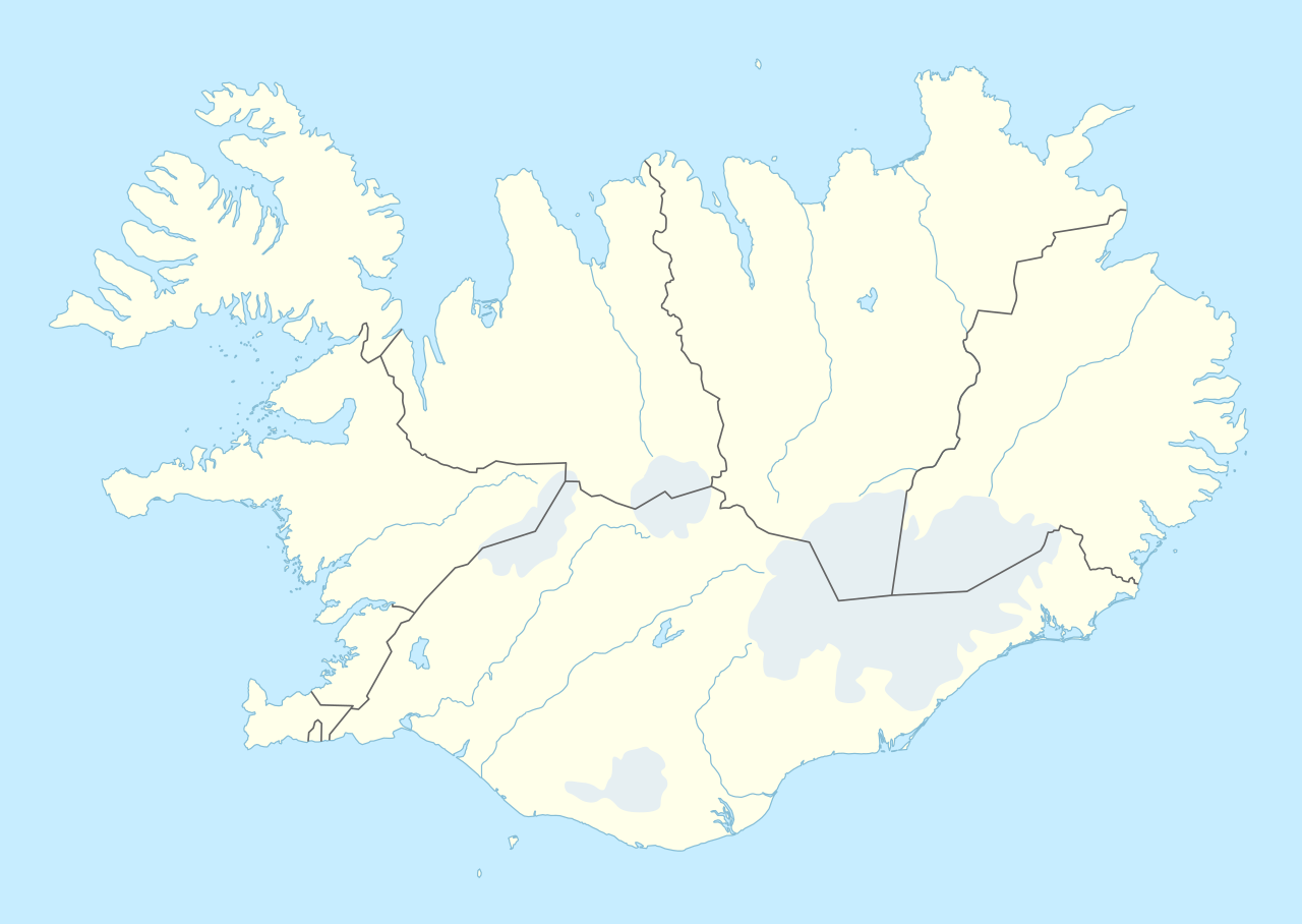
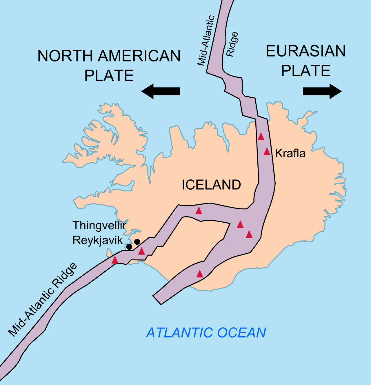


.jpeg/1280px-Eldgj%C3%A1_Volcanic_Canyon_Iceland_(176657459).jpeg)

.jpg/1280px-Esja_(2571116699).jpg)


.jpg/1280px-Iceland_2008-05-25_(2597414926).jpg)

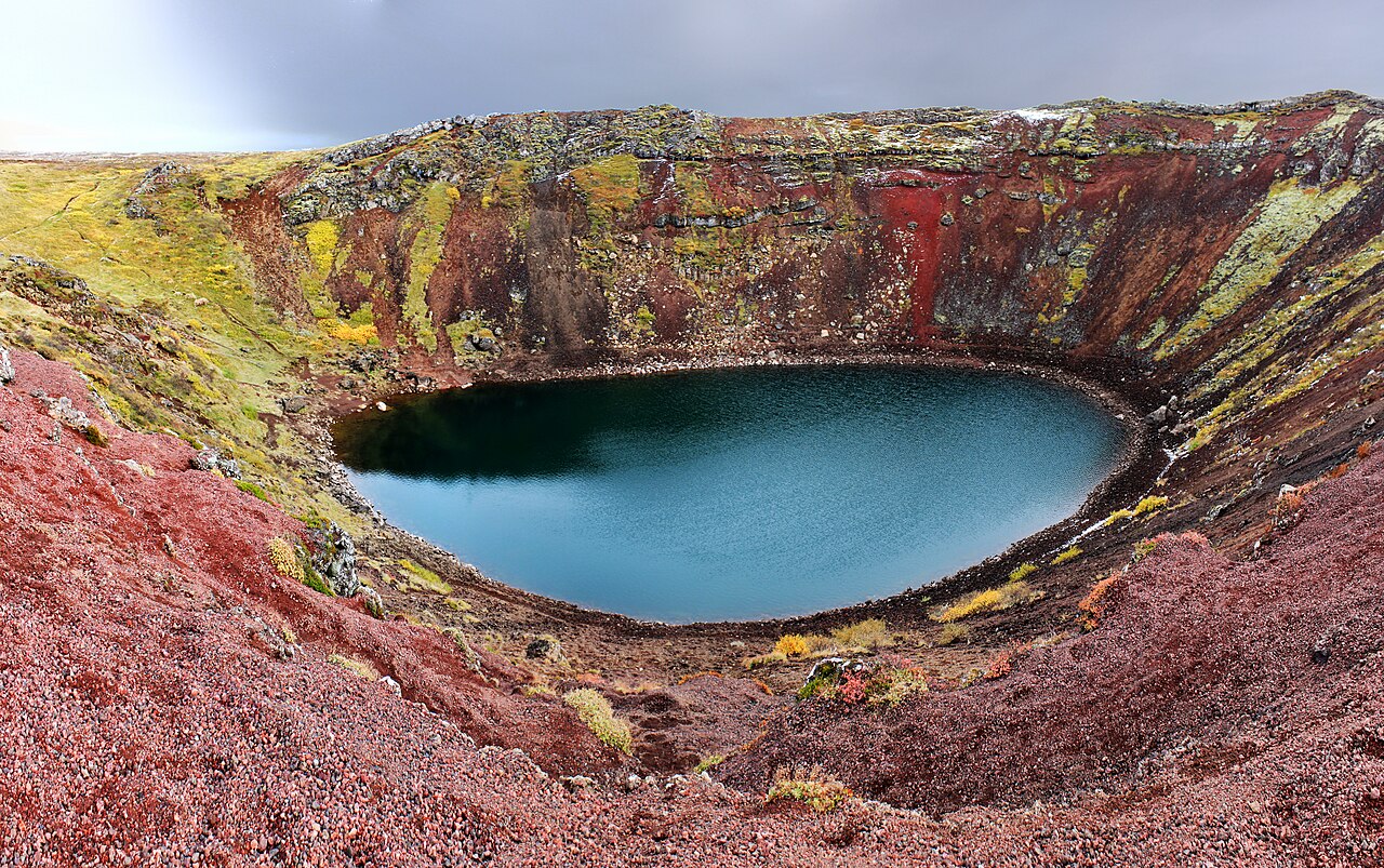


_Detail_from_map_of_Iceland_1585.jpg/1280px-Hekla_(A._Ortelius)_Detail_from_map_of_Iceland_1585.jpg)


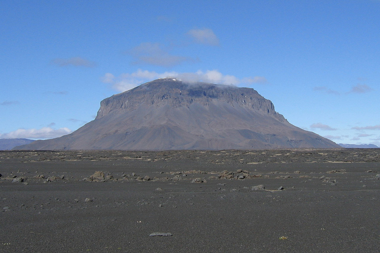

,_13._September_2014.JPG/1280px-Fissure_eruption_in_Holurhraun_(Iceland),_13._September_2014.JPG)

.jpeg/1280px-Blue_Hole_In_Hveravellir_Iceland_(40913978).jpeg)


.jpg/1280px-Laki_fissure_(3).jpg)
.jpg/1280px-Laki_fissure_(2).jpg)


.jpg/1280px-Sn%C3%A6fellsj%C3%B6kull_in_the_Morning_(7622876302).jpg)


.JPG/1280px-Shield-volcano-iceland_(cropped).JPG)


