El Endeavour visto desde la órbita de MarteLa punta de la parte inferior derecha de la estrella es la ubicación aproximada del cráter Endeavour en Marte.Opportunity capta un torbellino marciano en el suelo del Endeavour (abril de 2016)
En comparación con las llanuras circundantes, el fondo del cráter muestra una firma espectral mejorada de basalto y hematita . [7] El interior contiene dos grupos de campos de dunas. Las imágenes tomadas desde 2008 muestran evidencia de cambios en algunas de las formaciones asociadas, que pueden ser evidencia de erosión activa por el viento marciano durante un período de dos a tres años. [6] Las llanuras que rodean el borde muestran evidencia de sulfato polihidratado. [7]
El Mars Exploration Rover -B Opportunity comenzó a viajar hacia este cráter en agosto de 2008, [1] y el borde apareció a la vista el 7 de marzo de 2009, [8] y llegó al borde el 9 de agosto de 2011. [9]
El cráter Endeavour tiene una profundidad media de 200 a 300 metros (660 a 980 pies), con un área en su sureste que desciende hasta los 500 metros (1.600 pies) de profundidad, según una publicación llamada Degradación del cráter Endeavour, Marte, del Instituto Smithsonian. [10] La depresión suroeste desciende hasta una elevación de -1.980 metros (-6.500 pies), la depresión con forma de herradura se encuentra en el cuadrante sureste y está a alrededor de -1.800 a -1.900 metros (-5.900 a -6.200 pies) de elevación, que está a unos 400 metros (1.300 pies) por debajo de las llanuras circundantes. [10] Se observa que el cráter ha sufrido varios procesos de erosión, siendo el viento una de las causas. [10]
Nomenclatura
La Unión Astronómica Internacional nombró al cráter en honor a una ciudad de Canadá . [3] El nombre fue aprobado el 20 de octubre de 2008. [11] Debido a las reglas para nombrar cráteres, oficialmente lleva el nombre de la ciudad canadiense, pero la razón por la que se propuso este nombre fue porque el equipo del rover estaba usando apodos informales basados en un viaje del HMS Endeavour . [4]
Se entiende que en la década de 2010 el cráter tiene dos tipos principales de roca, la Formación Shoemaker y la Formación Matijevic. [13] Se ha clasificado como un cráter complejo y se cree que es tan antiguo que muchas de sus características se han desgastado. [13] Se plantearon algunas preguntas sobre la inclinación del borde, sin embargo, la comprensión se ve obstaculizada por la falta de conocimiento sobre los cráteres de impacto marcianos: Endeavour fue el cráter de impacto marciano más grande hasta ese momento en ser estudiado tan de cerca. [13] Un ejemplo de la dificultad de estudiar las características de Marte también es evidente con Orcus Patera , que tiene varias explicaciones de eventos volcánicos, tectónicos o de craterización para su formación. [14] Una famosa realización de Marte fue que lo que entonces se llamaba Nix Olympica era un volcán, y luego rebautizado como Olympus Mons gracias a las observaciones del orbitador Mariner 9 a principios de la década de 1970. [15] Se identificó que el Endeavour tenía minerales arcillosos, según lo detectado desde la órbita por el Mars Reconnaissance Orbiter , lo que según las teorías de ese momento indicaba que se trataba de rocas de un período más antiguo y húmedo en Marte. [16] Este tipo de roca es diferente de la que prevalece en otras áreas de las llanuras circundantes. [16]
En Endeavour se identificó lo que se espera que sea un barranco tallado por fluidos, probablemente agua. [17] Este barranco está previsto que sea explorado por la misión del rover MER-B a partir de octubre de 2016. [17] Llegó al barranco en 2017 y se lo denominó Valle de la Perseverancia.
Mapa mineral de los alrededores
Coloreado para minerales. La travesía de Opportunity se remonta a 2010, cuando todavía se dirigía hacia Endeavour. El color se basa en información geológica observada por el instrumento CRISM del Mars Reconnaissance Orbiter
Borde occidental
El cráter Endeavour
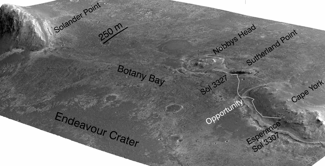
Borde occidental del cráter visto desde el cabo York hacia el sur, con la primera cresta siendo Solander PointImagen de Hazcam de Botany Bay y Solander Point (2013)Imagen MER-B NavCam Sol 4959 [18] Principios de enero de 2018, mirando a lo largo del borde del Endeavour al sur del barranco (PV)Mapa comentado de varias ubicaciones en el borde occidental del Endeavour
Valle de la Perseverancia, red de erosión en esta sección del borde, alcanzada por MER-B en 2017 [22]
Cabo Dromedario
Punto Hicks
Estrecho de Torres (desde el final de Point Hicks hasta Batavia en el borde sur)
La siguiente sección del borde que avanza en sentido contrario a las agujas del reloj alrededor del cráter es Batavia, en el extremo sur de todo el cráter, pero al este del estrecho de Torres.
Mapa de minerales del borde occidental
Este es un mapa geológico basado en las observaciones CRISM de MRO [23]
Imagen de la cámara de contexto MRO del borde occidental del Endeavour
Secciones del borde occidental desde Solander hasta Marathon
3492 (noviembre de 2013)
Travesía a partir de noviembre de 2013, hasta el sol 3492
3500 a 3689 (junio de 2014)
Travesía a partir de junio de 2014 desde aproximadamente sol 3500 a 3689
3728 a 3757 (agosto de 2014)
Aproximadamente en el centro se encuentra el cráter Ulises, visitado por MER-B alrededor del Sol 3790 (septiembre de 2014) [20]
Travesía a partir de agosto de 2014 desde aproximadamente el sol 3728 hasta el 3757
3750 a 3869 (diciembre de 2014)
El cráter Ulises se encuentra aproximadamente en el centro superior y fue visitado por MER-B alrededor del Sol 3790 (septiembre de 2014) [20]
Travesía a partir de diciembre de 2014 desde aproximadamente sol 3750 a 3868
3870 a 4209 (diciembre de 2015)
Travesía a partir de diciembre de 2015 desde aproximadamente el sol 3870 hasta el 4227
Octubre 2016 (con etiquetas)
Explorado por el rover MER-B, varias ubicaciones, incluido el cráter Spirit of St. Louis con Lindberg Mound, Marathon Valley, el paso Lewis y Clark y Spirit Mound, entre otras características en el borde occidental o muy cerca de él.
Mapa de travesía hasta octubre de 2016 (versión anotada)
hasta 4625 (enero de 2017)
Mapa de travesía hasta el 27 de enero de 2017 (Sol 4625)
hasta 4695 (abril de 2017)
Cabo Tribulación y Cabo Byron
Mapa de travesía hasta el 11 de abril de 2017 (Sol 4695) [24]
Hasta 4836 (septiembre de 2017)
A lo largo de 2017, Opportunity avanzó hacia el sur a lo largo del borde occidental mientras se dirigía hacia el barranco, que el equipo denominó Valle de la Perseverancia en abril de 2017. [22] [25]
Mapa de travesía hasta 4836 (12 de septiembre de 2017) [26]Imagen HiRise de MRO superpuesta a un mapa topográfico tridimensional del terreno, con una exageración vertical de cinco veces; vista hacia el oeste en el valle Perseverance en el borde occidental del Endeavour (15 de febrero de 2018) [27]
Borde oriental
Llegada a Spirit Point en Endeavour, a lo lejos se ve el fondo del cráter y al otro lado los segmentos del borde oriental.Borde oriental del Endeavour, la franja en blanco y negro tiene aproximadamente 5 km de ancho y la franja en color 1 km [28]Parte del borde oriental visto por MER-B
Oportunidad
MER-B ha realizado tantos descubrimientos nuevos en el cráter que el equipo del rover comparó a Endeavour con el equivalente a un segundo lugar de aterrizaje para Opportunity . [29] [30] Por ejemplo, en el sol 2692 (22 de agosto de 2011) el rover comenzó a examinar Tisdale 2, un gran bloque de material expulsado. "Esto es diferente de cualquier roca vista hasta ahora en Marte", dijo Steve Squyres , investigador principal de Opportunity en la Universidad de Cornell en Ithaca, Nueva York. [29]
El recorrido de Opportunity hasta marzo de 2015 desde su lugar de aterrizaje hasta Endeavour. Ha recorrido el borde occidental hacia el sur y las naves espaciales en órbita han ayudado a recopilar datos sobre el borde, lo que a su vez permite al rover investigar más de cercaAutorretrato de Opportunity cerca de Endeavour en la superficie de Marte (6 de enero de 2014).
El viaje a Endeavour
Imagen anotada que muestra la posición de Opportunity en mayo de 2009 y los nombres de los cráteres Iazu, Endeavour y Victoria
En agosto de 2008, el rover de exploración marciano Opportunity B se dispuso a alcanzar a Endeavour y comenzó un viaje hacia él. [1] [31] Algunos cráteres que Opportunity exploró anteriormente incluyen el cráter Victoria , que tiene 750 metros (0,47 millas) de diámetro, el cráter Endurance , que tiene 130 metros (0,081 millas) de diámetro, y el cráter Eagle , que tiene 22 metros (0,014 millas) de diámetro. [32] [33] [34]
El 7 de marzo de 2009 (sol 1.820), Opportunity fotografió por primera vez el borde del Endeavour después de conducir unos 3,2 kilómetros (2,0 millas) desde que salió de Victoria en agosto de 2008. [8] [35] Opportunity también fotografió el cráter Iazu , que está a unos 38 kilómetros (24 millas) de distancia y tiene unos 7 kilómetros (4,3 millas) de diámetro. [35] En ese momento, Opportunity estaba a 12 kilómetros (7,5 millas) de Endeavour en línea recta marciana, pero para evitar peligros, se estimó que se necesitaría aproximadamente un 30% más de distancia en coche que eso para llegar a Endeavour. [8] Basándose en la cantidad de tiempo que había tardado en conducir desde Victoria, se estimó que este viaje duraría más de un año marciano (23 meses). [8] El 5 de mayo de 2010, para evitar los peligrosos campos de dunas a lo largo del camino directo entre Victoria y Endeavour, la ruta trazada entre los dos cráteres se extendió a unos 19 kilómetros. [36]
On September 8, 2010, it was announced that Opportunity had reached the halfway point of the 19-kilometer journey between Victoria and Endeavour.[37] By June 28, 2011, Opportunity was just under 2 kilometers (1.2 mi) from landfall at the rim of Endeavour.[38]
On August 4, 2011, Opportunity was only 120 meters (390 ft) from the rim of Endeavour,[39] and on August 9, 2011 Opportunity arrived at the west rim near Spirit Point to study outcrops never seen before.[9]
When it arrived it explored the northwest outcrops at Cape York (Mars) of the crater before heading south to Solander Point and the Western rim.[40]
MER-B on Sol 2239 imaged the then distant crater rim. On this map several locations of Endeavour are identified including: Cape Tribulation, Cape Bryon, Cape Dromedary, Point Hicks, Torres Strait, and Batavia. Further south the nearby crater Iazu is also marked.Here is the view from the rover's perspective from that location noted in the above top-down view. The white lines indicate the rover's field of view
MER-B eventually reached Cape Tribulation, and took a panorama from its top: Opportunity's view from Cape Tribulation on the rim of Endeavour, January 22, 2015.
Opportunity's traverse up to February 2015 as it approached Spirit of St. Louis Crater and Marathon Valley, and came close to traveling the distance of a traditional marathon (about 26 miles or 42 km)
Solander point
Solander PointLooking west in this topographic view overlaid photo, Solander is to the left, then moving right Botany Bay, and Cape York
Homestake Vein
"Homestake" vein
In December 2011, Opportunity rover discovered a vein of gypsum sticking out of the soil along the rim of Endeavour. Tests confirmed that it contained calcium, sulfur, and water. The mineral gypsum is the best match for the data. It likely formed from mineral-rich water moving through a crack in the rock. The vein is called "Homestake." It could have been produced in conditions more neutral than the harshly acidic conditions indicated by the other sulfate deposits; hence this environment may have been more hospitable for a large variety of living organisms. Homestake is in a zone where the sulfate-rich sedimentary bedrock of the plains meets older, volcanic bedrock exposed at the rim of Endeavour.[41][42]
Wdowiak Ridge
A view looking north-north west with the Western and Northwest Endeavour segments
Wdowiak Ridge on the North-Western rim of Endeavour. MER-B recorded this panorama on Sept. 17, 2014 (Sol 3,786)[43]
Proximity to Schiaparelli landing ellipse
In October 2016 ESA's Schiaparelli lander attempted to re-use the proven Meridiani Planum landing site, with a landing ellipse that kisses the Endeavour crater location where Opportunity was still functioning.[44] This allowed the opportunity for Opportunity to attempt to image the lander during its descent from the surface of Mars.[44] Contact was lost during descent
MRO Context Camera images of Schiaparelli landing site; before (29 May 2016) and after (20 October 2016). The large black spot indicates the impact by the lander, and the white spot its parachute.[45]
Proximity to MSL landing site candidates
Two of the seven final landing candidates for MSL were relatively near to Endeavour, one was in Miyamoto (crater) and another was south of Endeavour in southerner Meridiani.[46]Gale (crater) won the selection
Endeavour can be seen on the right side of this map about halfway down; in the bottom left is the proposed landing ellipse for MSL in the crater Miyamoto.
Cape Tribulation
MER-B from 2011 to 2016 explored the Western rim of Endeavour, starting at Cape York (Mars) then moving down through Botany Bay to Solander Point, along Murray Ridge moving south to Marathon Valley; in late 2016 it began moving inward to the crater floor: It then moved back to the rim and went south to gully named Perseverance Valley, leaving the Cape Tribulation section, and heading towards Cape Bryon.
A detailed-class rover traverse map by the mission, released on September 28, 2016, showing the track of the rover up to Sol 4500 as it heads deeper in EndeavourAn annotated view of the traverse to Spirit mound, October 2016
Marathon Valley, 2016[47]
Marathon Valley as viewed by the Opportunity rover (false color; stereo; March 13, 2015).
Opportunity looks at the southern end of Cape Tribulation as it heads south, showing how the Western rim ridge[48]In March 2016, while trying to reach target on the slope of Marathon Valley in Cape Tribulation, the Mars rover attained a slope of 32 degrees, the highest angle yet for the rover since its mission began. This was so steep that dust that had accumulated on its top panels began to flow downward.[49]
Spirit of St. Louis
This crater sits at the Western mouth of Marathon Valley, south Cape Tribulation on the western rim of Endeavour. It was visited by the MER-B Opportunity rover in May 2015.[50]
In May 2015 the rover visited what was dubbed Spirit of St. Louis, a shallow crater about 110 feet (34 meters) long and 80 feet (24 meters) across. In its center is Lindbergh Mound, about 2-3 meters (yards) high. This version of the panorama is annotated and in false color[51]
Above Perseverance Valley by Opportunity
Perseverance Valley is an erosion network in the Cape Bryon section of the Western Endeavour rim.[22] It was named in April 2017 by the MER-B team, which previously referred to it as the gully.[22]
Above Perseverance Valley, July 2017
Context
The proposed landing ellipse in Miyamoto when it was one of seven finalists under consideration as a landing site for MSL.[46] Endeavour can be seen on the right side of the map, the top of three medium-sized craters in a north–south line. This map is color-coded based on elevation.
Map showing the location of Endeavour and other, nearby features
Comparison
Endeavour is about the same size as Valles Caldera in the U.S. State of New Mexico, a volcanic Caldera of the Valles Caldera National Preserve.[20] Endeavour has been compared to the Mars craters' Santa Fe (crater), which is about 20.2 km in diameter, and also to Tooting (crater), which is 27.5 km in diameter.[10]
^ a b c d"NASA'S Mars Rover to Head Toward Bigger Crater". NASA/JPL. 2008-09-22. Retrieved 2009-03-20.
^"Road Trip Gets Under Way". NASA/JPL. 2008-09-24. Retrieved 2009-04-27.
^ a b"Planetary Names: Crater, craters: Endeavour on Mars". Gazetteer of Planetary Nomenclature. Retrieved 2016-02-14.
^ a b c"Mars Exploration Rovers Update: Opportunity Embarks on New Endeavour, Spirit Gets Back To Normal Schedule | The Planetary Society". planetary.org. Retrieved 2018-08-16.
^Wray, J. J.; et al. (November 2009), "Phyllosilicates and sulfates at Endeavour Crater, Meridiani Planum, Mars", Geophysical Research Letters, 36 (21): L21201, Bibcode:2009GeoRL..3621201W, doi:10.1029/2009GL040734{{citation}}: CS1 maint: multiple names: authors list (link)
^ a bChojnacki, M.; Burr, D. M.; Moersch, J. (March 2010), "Recent Dune Changes at Endeavour Crater, Meridiani Planum, Mars, from Orbital Observations", 41st Lunar and Planetary Science Conference, held March 1–5, 2010, The Woodlands, Texas, p. 2326, Bibcode:2010LPI....41.2326C{{citation}}: CS1 maint: location missing publisher (link)
^ a bChojnacki, M.; Moersch, J.; Wray, J. J.; Burr, D. M. (March 2010), "The Stratigraphy, Composition and Thermophysical Properties of Endeavour Crater, Meridiani Planum, Mars, from Orbital Remote Sensing", 41st Lunar and Planetary Science Conference, held March 1–5, 2010, The Woodlands, Texas, p. 2175, Bibcode:2010LPI....41.2175C{{citation}}: CS1 maint: location missing publisher (link)
^ a b c d"One Mars Rover Sees A Distant Goal; The Other Takes A New Route". NASA/JPL. 2009-03-18. Retrieved 2009-03-20.
^ a b"NASA Mars Rover Arrives at New Site on Martian Surface" (Press release). NASA/JPL. 2011-08-10. Archived from the original on 2012-11-03. Retrieved 2016-02-14.
^ a b c d e f"Degradation of Endeavour Crater, Mars" (PDF). 2015-03-27. Retrieved 2018-08-16.
^"NASA Mars Rover Seeing Destination in More Detail". Mars Exploration Rover Mission: Press Release Images: Opportunity. 29 June 2010. Archived from the original on 2011-09-28. Retrieved 2022-12-31.
^ a b c"Endeavour rim rocks slope "wrong" way | Red Planet Report". redplanet.asu.edu. Retrieved 2018-08-16.
^"HRSC Press Release #471 - Orcus Patera (orbit 2216 & 2238)". 2010-08-27. Archived from the original on 2014-08-07.
^"ch9-4". solarviews.com. Retrieved 2018-08-16.
^ a b"NASA Rover Arrives at Huge Mars Crater After 3-Year Trek". space.com. 10 August 2011. Retrieved 2018-08-16.
^ a b"News | NASA's Opportunity Rover to Explore Mars Gully". jpl.nasa.gov. Retrieved 2018-08-16.
^mars.nasa.gov. "Mars Exploration Rover Mission: Multimedia: All Raw Images: Opportunity: Navigation Camera: Sol 4959". mars.nasa.gov. Retrieved 2018-08-16.
^ a b c d"Mars Exploration Rovers Update: Opportunity Heads for New Discovery as Winter Blows In at Cape York | The Planetary Society". planetary.org. Retrieved 2018-08-16.
^ a b c d"Sol 3790 | New Mexico Museum of Natural History & Science". nmnaturalhistory.org. Retrieved 2018-08-16.
^"NASA's Mars Rover Opportunity Leaves 'Tribulation' – NASA's Mars Exploration Program". mars.nasa.gov. Retrieved 2018-08-16.
^ a b c d"Mars Exploration Rovers Update: Opportunity Dodges Dust Storms, Makes Tracks to Perseverance Valley". www.planetary.org. Retrieved 2018-02-08.
^"Space Images | Geologic Map, West Rim of Endeavour, Mars". jpl.nasa.gov. Retrieved 2018-08-16.
^mars.nasa.gov. "Mars Exploration Rover Mission: the Mission". mars.nasa.gov. Retrieved 2018-08-16.
^"The Mars Exploration Rovers Update: Opportunity Closes in on Perseverance Valley". www.planetary.org. Retrieved 2018-02-08.
^mars.nasa.gov. "Mars Exploration Rover Mission: the Mission". mars.nasa.gov. Retrieved 2018-08-16.
^"Martian 'Perseverance Valley' in Perspective (Vertical Exaggeration) – NASA's Mars Exploration Program". mars.nasa.gov. Retrieved 2018-08-16.
^"HiRISE | Eastern Rim of Endeavour (ESP_012477_1775)". hirise.lpl.arizona.edu. Retrieved 2018-08-16.
^ a bFitzpatrick, Tony (14 September 2011). "Opportunity on verge of new discovery".
^"NASA's Mars Rover Opportunity begins study of Martian crater". DefenceWeb. September 6, 2011.
^Rahl, A.J.S. (2008-10-31). "Spirit "Bumps" a Move, Opportunity Puts the Pedal to the Metal". Planetary Society. Archived from the original on 2012-10-21. Retrieved 2009-03-20.
^"NASA Rover Nears Martian Bowl Goal". NASA/JPL. 2006-09-06. Archived from the original on 2006-09-29. Retrieved 2009-03-20.
^"Press Release Images: Opportunity". NASA/JPL. 2004-05-03. Archived from the original on 2004-11-17. Retrieved 2009-03-20.
^"NASA Facts: Mars Exploration Rover" (PDF). NASA/JPL. 2004-10-24. Archived from the original (PDF) on 2009-03-27. Retrieved 2009-03-26.
^ a b"One Mars Rover Sees A Distant Goal; The Other Takes A New Route". NASA/JPL. 2009-03-18. Retrieved 2009-03-20.
^"Opportunity's Long and Winding Road to Endeavour Crater". Universe Today. 2010-05-05. Retrieved 2010-08-04.
^"Opportunity Rover Reaches Halfway Point of Long Trek". NASA/JPL. 2010-09-08. Retrieved 2010-09-11.
^"Opportunity Is Just Over a Mile From Crater Rim". NASA/JPL. 2011-07-08. Archived from the original on 2014-06-20. Retrieved 2011-07-08.
^"Nearing First Landfall of Large Crater". NASA/JPL. 2011-08-04. Archived from the original on 2014-06-20. Retrieved 2011-08-08.
^"Mars Exploration Rover Mission: All Opportunity Updates". marsrovers.jpl.nasa.gov. Archived from the original on 2014-06-20. Retrieved 2018-08-16.
^"NASA - NASA Mars Rover Finds Mineral Vein Deposited by Water". NASA. Archived from the original on 2017-06-25. Retrieved 2018-08-16.
^"NASA - NASA Mars Rover Finds Mineral Vein Deposited by Water". Archived from the original on 2017-06-15. Retrieved 2022-07-21.
^"Catalog Page for PIA18614". photojournal.jpl.nasa.gov. Retrieved 2018-08-16.
^ a b"Schiaparelli Lander to Touch Down on Mars - Sky & Telescope". skyandtelescope.com. Retrieved 2018-08-16.
^Webster, Guy (21 October 2016). "Camera on Mars Orbiter Shows Signs of Latest Mars Lander". NASA. Retrieved 2016-10-24.
^ a bJPL, NASA. "Seven Possible MSL Landing Sites - Mars Science Laboratory". mars.nasa.gov. Retrieved 2018-08-16.
^"Catalog Page for PIA20749". photojournal.jpl.nasa.gov. Retrieved 2018-08-16.
^"Catalog Page for PIA21497". photojournal.jpl.nasa.gov. Retrieved 2018-08-16.
^"Streaks on Opportunity Solar Panel After Uphill Drive – NASA's Mars Exploration Program". mars.nasa.gov. Retrieved 2018-08-16.
^mars.nasa.gov. "Mars Exploration Rover Mission: Press Release Images: Opportunity | Martian Reminder of a Pioneering Flight". mars.nasa.gov. Retrieved 2018-08-16.
^mars.nasa.gov. "Mars Exploration Rover Mission: Press Release Images: Opportunity | Martian Reminder of a Pioneering Flight". mars.nasa.gov. Retrieved 2018-08-16.
External links
Wikimedia Commons has media related to Endeavour crater.
Official Mars Rovers website
Opportunity: Iazu Crater profiles (As seen from rim of Endeavour crater)
Endeavour crater as seen during MER-B's approach to the crater with some locations noted around the crater
HiRise Analysis of the Western Rim of Endeavour Crater, Meridiani Planum, Mars: Morphology, Composition and Topography. University of Tennessee
HiRise - search for Endeavour crater related images
HiRise - DTM - North-Central Endeavour Crater
HiRise - DTM - Endeavour Crater Western Rim
DLR - ExoMars Schiaparelli's landing site on Mars 11 August 2016


