Most of the walled villages of Hong Kong are located in the New Territories.
History
During the Ming and Qing dynasties, the shore of Guangdong suffered from pirates, and the area of present-day Hong Kong was particularly vulnerable to pirates' attacks. Winding shores, hilly lands and islands and remoteness from administrative centres made the territory of Hong Kong an excellent hideout for pirates. Villages, both Punti and Hakka, built walls against them. Some villages even protected themselves with cannons. Over time, the walls of most walled villages have been partly or totally demolished.
Names
In Punti Cantonese, Wai (圍, Walled) and Tsuen (村, Village) were once synonyms, hence most place names which include the word 'wai', were at some point in time a walled village.
Walled villages in Hong Kong are characterised by row houses arranged in a square or rectangular block, where the parallel rows of houses are separated by narrow lanes.[2]
Kat Hing Wai (吉慶圍) is a noted Punti walled village in Yuen Long District of Hong Kong.[citation needed] It often mistakenly believed to be Hakka, whose people have similar traditions.[citation needed] However the Punti people were from Southern China and the first to settle in Hong Kong. Kat Hing Wai's residents speak Cantonese, rather than Hakka.[citation needed] Popularly known as Kam Tin, from the name of the area, it is home to about 400 descendants of the Tang Clan, who built the village back in the 17th century.
Kat Hing Wai is a rectangular (100 m x 90 m) walled village. As a family stronghold, Kat Hing Wai has served the Tangs well through the centuries, protecting the residents against bandits, rival clans, and wild tigers. During the Qing dynasty, a five-metre high blue brick wall and four cannon towers were added to defend against bandits. Today, the village is still completely surrounded by 18-inch-thick walls,[citation needed] outside which are the remains of a moat. However, most houses within the walls have been rebuilt in recent years. There is only one narrow entrance, with a pair of iron gates.
Tsang Tai Uk
External view of Tsang Tai Uk.
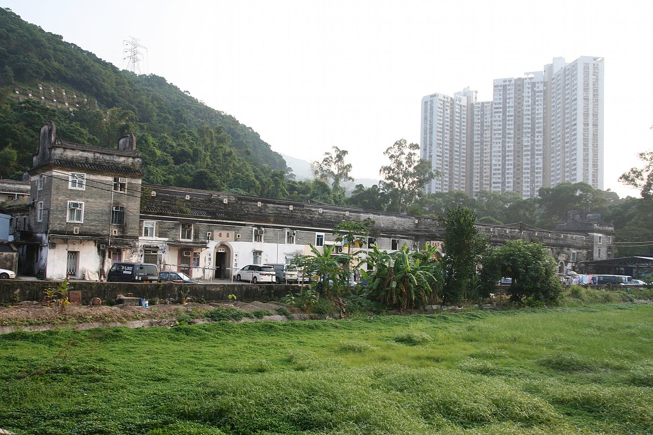
Tsang Tai Uk (曾大屋), also known as Shan Ha Wai (山下圍),[3] is another well-known Hakka walled village in Hong Kong, and one of the best preserved. It is located in Sha Tin, close to the south of the Pok Hong Estate, not far from the Lion Rock Tunnel Road. Built as a stronghold for the Tsang Clan, its construction started in 1847 and took around 20 years to complete. The village is built with granite, grey bricks, and solid timber.
Sheung Shui Wai
Sheung Shui Wai (上水圍), also known as Sheung Shui Heung (上水鄉), is one of the very few rural settlements having retained its original moat which was built in 1646. Characterized by its magnificent moat and landscape setting, the walled village is the core of the Liu clan, of which ancestors came originally from Fujian during the Yuan dynasty (1271–1368). The village is located in Sheung Shui.
Fanling Wai
Houses reflecting in a pond at Fanling Wai.
Fanling Wai (粉嶺圍) is a walled village in Fanling built by the Pang (彭) Clan. It is recognisable with the distinctive pond and layout including features such as cannons and watchtowers. All these elements were crafted to form an integral part of the village setting. Fanling Wai is the centre of the Pang Clan who arrived in Hong Kong late during the Song dynasty.[4]
Nga Tsin Wai Tsuen
Nga Tsin Wai Tsuen (衙前圍村) is a walled village in Wong Tai Sin, New Kowloon. It is the only walled village left in the urban built-up areas of Hong Kong. Nga Tsin Wai Tsuen is also the only remaining walled village in Kowloon. It is located near San Po Kong. On 18 July 2007, the government announced its plans to redevelop Nga Tsin Wai Tsuen.[5]
List of walled villages
Remaining walled villages in Hong Kong include:
North District
Sha Tin District
Tai Po District
Tsuen Wan District
Tuen Mun District
Wong Tai Sin District
Yuen Long District
Unconfirmed
The following villages are likely to have been walled villages, although it is not confirmed:[46]
Other fenced villages
A number of old villages in Hong Kong have a wall, built for defensive or feng shui purposes, and an entrance gate, but are not considered as traditional walled villages. They include:
Non-walled 'wai'
The following villages are neither current nor former walled villages, despite the wai in their name:[46]
^Jeffrey W. Cody and James R. Richardson (1997). "Urbanizing forest and Village Trees in Hong Kong's Sha Tin Valley, 1976–1997" (PDF). Traditional Dwellings and Settlements Review. IX (1): 24. Archived from the original (PDF) on 9 January 2016.
^ a bHill, Ronald D. (1985). "Fragments and speculations: the walled villages of Hong Kong". Journal of the Hong Kong Archaeological Society. 11. Hong Kong Archaeological Society: 25-38. OCLC 02465191.
^ a b cAgreement No. CE 45/2008 (CE) Liantang / Heung Yuen Wai Boundary Control Point and Associated Works -Environmental Impact Assessment Report. Appendix 12.2f: Detailed Records of Identified Built Heritage Features within CHIA Study Area of the Lau Shui Heung Tunnel Section (South Tunnel)
^SCL – NEX/2206 EIA Study for Tai Wai to Hung Hom Section. Environmental Impact Assessment Report.Appendix 4.3. Built Heritage Survey. October 2011
^East Rail Extensions – Tai Wai to Ma On Shan. Environmental Impact Assessment Report. Archaeological and Cultural Resources, 1999
^SCL – NEX/2206 EIA Study for Tai Wai to Hung Hom Section, Final Environmental Impact Assessment Report, Figure 4.2.1. Locations of Known Built Heritages (Sheet 1 of 8), October 2011. Shows the location of the historic buildings of Tin Sam Village.
^ a bIp, Hing-fong (1995). An historical geography of the walled villages of Hong Kong (Postgraduate Thesis, Master of Philosophy). University of Hong Kong.
Ali, Jason R.; Hill, Ronald D. (2005). "Feng Shui and the orientation of traditional villages in the New Territories, Hong Kong" (PDF). Journal of the Royal Asiatic Society Hong Kong Branch. 45: 27–39. ISSN 1991-7295.
Chan, Chi Sing Rex (2006). "Transformation of Two Walled Villages in Kam Tin" (PDF). HKIA Journal. 46. Hong Kong Institute of Architects: 56–58.
Hill, Ronald D. (1984). "Fragments and speculations: the walled villages of Hong Kong". Journal of the Hong Kong Archaeological Society. 11. Hong Kong Archaeological Society: 25-38. OCLC 02465191.
Ip, Hing-fong (1995). An historical geography of the walled villages of Hong Kong (Postgraduate Thesis, Master of Philosophy). University of Hong Kong.
Wang, Weijen (December 1998). "Axial Inversion – the transformation of the spatial structure and its ritual axis in Hong Kong's walled villages" (PDF). Hong Kong Papers in Design and Development. 1: 26–33.
External links
Wikimedia Commons has media related to Walled villages of Hong Kong.
Map all coordinates using OpenStreetMap
Download coordinates as:
KML
GPX (all coordinates)
GPX (primary coordinates)
GPX (secondary coordinates)
The Walled Villages of Hong Kong: Typology and Continuity

.jpg/1280px-Model_of_Kun_Lung_Wai,_Fanling_(Exhibit_of_HKHM).jpg)


.jpg/1280px-HK_KamTin_KatHingWai_2014_(brighter_version).jpg)

