The principal built-up area in the borough is the Milton Keynes urban area, which accounts for about 20% of its area and 90% of its population. The borough also includes many rural areas surrounding the Milton Keynes urban area (especially to the north), containing several villages and the town of Olney. At the 2021 census, the population of the unitary authority area was just over 287,000.[4]
History
The district was created on 1 April 1974 under the Local Government Act 1972, covering the whole area of four former districts and part of a fifth, which were all abolished at the same time:[5]
The new district was named Milton Keynes (after its largest settlement).[6] The district was given borough status from its creation, allowing the chair of the council to take the title of mayor.[7]
Arising from the local government elections of May 2024, the borough is governed by a Labour administration. The Liberal Democrat party is the main opposition group.
In the 2024 Labour gained 4 seats to become the majority party, having previously been part of a joint Labour-Lib-Dem run administration.
Economy
According to data from the Office for National Statistics for 2017, the borough was the highest performing NUTS3 region in the UK outside inner London (which takes the first five places), on the basis of gross value added per head.[10]
Cranfield University is the academic partner in project with Milton Keynes City Council to establish a new university, code-named "MK:U",
on a reserved site in the city centre.[11] As of January 2022[update], the project is stalled pending assurance of government funding.[12]
Demographics
Population
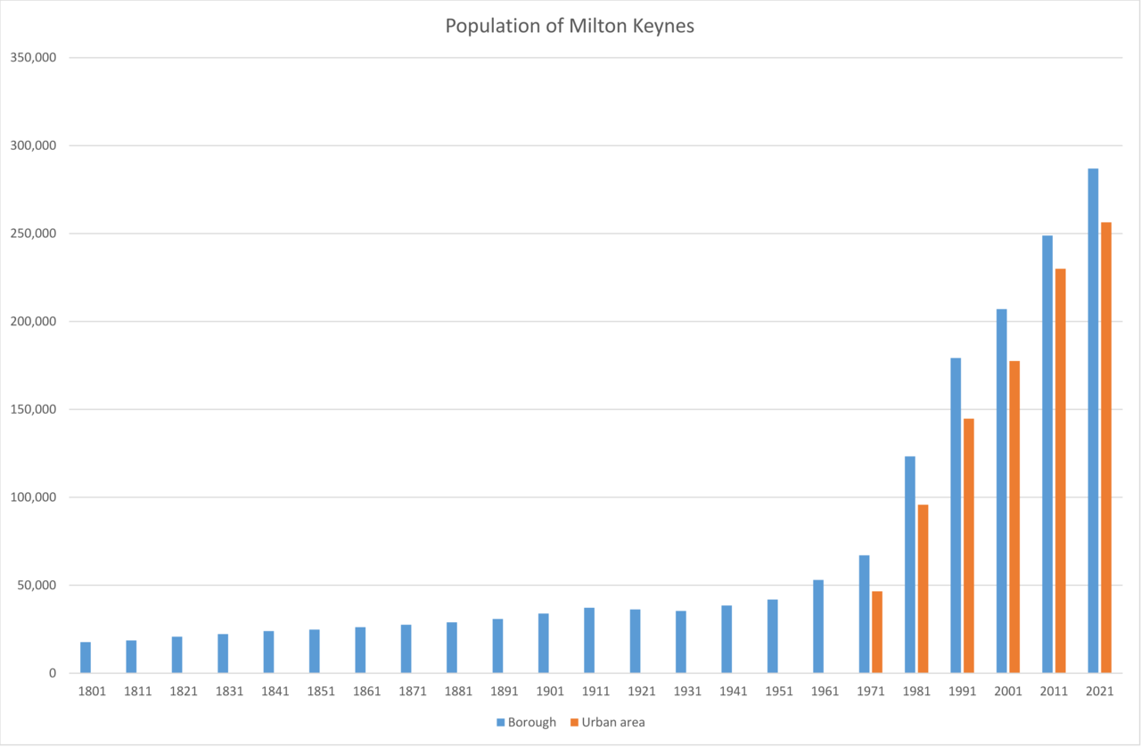
Population trend of borough and Urban Area 1801–2021.[13]Population of City of Milton Keynes (unitary authority area) in 2021[14]
At the 2021 census, the population of the borough was 287,060.[4] This was an increase of 15.3% from the 2011 census, when the population of the borough was 248,821.[15] By 2050, the City Council projects that the borough's population will reach 410,000.[16]
Education
At the 2021 census, of residents aged 16 and over, 15.8% had no qualifications, 10.9% had a level1 qualification, 14.2% had level2, 4.7% were in apprenticeship, 15.7% had level3, 35.8% had level4 and 2.9% had other qualifications.
Ethnicity
In the 2021 census, almost 71.8% of the population described their ethnic origin as white, 12.3% as Asian, 9.7% as black, 4% as mixed, and 2% as another ethnic group.[17]
Religion
The following table shows the religion of respondents in recent censuses in the city of Milton Keynes.
Housing and home ownership
Household tenure breaks down to 60.8% of dwellings owner-occupied, 21% of homes privately rented and 18% are socially rented.[4] Due to the borough's fast-growing population, the City Council plans for a minimum of 26,500 dwellings across the borough over the period between 2016 and 2031, with development primarily focused on city estates, expansion areas and strategic land locations in the south and east of Milton Keynes, Campbell Park (in CMK) and the three "Key Settlements" outside of the 1967 "designated development area" of Milton Keynes: Newport Pagnell, Woburn Sands and Olney.[24]
Public health
According to Public Health England, "The health of people in Milton Keynes is generally similar to the England average. About 15.1% (8,680) children live in low income families. Life expectancy for both men and women is similar to the England average."[25]
Settlements
Milton Keynes urban area
The urban area accounts for about 20% of the borough by area and 90% by population. This is a partial list of the districts of the Milton Keynes urban area.
The City of Milton Keynes is fully parished. These are the parishes, and the districts they contain, that are now elements of the Milton Keynes built-up area as defined by the Office for National Statistics.[26][b]
Great Linford: Bolbeck Park, Blakelands, Conniburrow, Downs Barn, Downhead Park, Giffard Park, Great Linford, Neath Hill, Pennyland, Redhouse, Tongwell, Willen Park
As of December 2023[update], the borough has 28 designated Neighbourhood Areas, of which 22 have made/adopted Neighbourhood Development Plans approved by the City Council, spanning both urban and rural parishes.[27]
Freedom of the City
The following people and military units have received the Freedom of the City (from 2022) or Freedom of the Borough (1982–2021).
^ a b"Crown Office | The Gazette". www.thegazette.co.uk. Retrieved 19 August 2022.
^ a b cUK Census (2021). "2021 Census Area Profile – Milton Keynes Local Authority (E06000042)". Nomis. Office for National Statistics. Retrieved 18 September 2023.
^"The Buckinghamshire (Borough of Milton Keynes) (Structural Change) Order 1995". Government of the United Kingdom. Retrieved 15 July 2020. (2) A new county shall be constituted comprising the area of Milton Keynes and shall be named the county of Milton Keynes.
^"Home - Office for National Statistics". www.ons.gov.uk. Retrieved 5 December 2022.
^"Plan:MK 2016-2031" (PDF). Milton Keynes City Council. Retrieved 12 December 2023.
^"Local Authority Health Profile 2019: Milton Keynes". Public Health England. 2019. Retrieved 22 August 2020.
^UK Census (2011). "Local Area Report – Milton Keynes Built-up area (E34005056)". Nomis. Office for National Statistics. Retrieved 29 March 2019. (includes map of the built-up area).
^"Neighbourhood Plans in Milton Keynes". Milton Keynes City Council. Retrieved 13 December 2023.
^ a b c d e fDavid Tooley (15 May 2020). "Tories want key workers in Milton Keynes to be awarded freedom of the borough". Milton Keynes Citizen. Retrieved 4 August 2020.
^"Football boss 'overwhelmed' by award". BBC News. 22 August 2015.
^"Proud city centre military march to commemorate Freedom of the Borough - Milton Keynes Council". www.milton-keynes.gov.uk.
^"Congratulations to MK's Leah Williamson and The Lionesses". Milton Keynes Council. 1 August 2022.
^Sally Murrer (28 February 2023). "England captain Leah Williamson awarded Freedom of the City of Milton Keynes". Milton Keynes Citizen. Retrieved 3 March 2023.
^"Rifles squadron rewarded for service with 'Freedom of Milton Keynes' honour". ITV News. 11 March 2018.
^The remainder of Buckinghamshire is also a Unitary Authority and is controlled by Buckinghamshire Council.
^This list excludes the civil parishes of Aspley Guise and Aspley Heath which, despite being in the contiguous built-up area, are in Central Bedfordshire and thus outside the City of Milton Keynes.
^So Milton Keynes (the village) is in Middleton (the grid square), which is in Milton Keynes (the civil parish), which is one of a number in Milton Keynes (the city), which in turn is in the City of Milton Keynes unitary authority district.
External links
Map on the Milton Keynes Council's website showing civil parishes in the borough.