stringtranslate.com

Lista de topónimos duales en Nueva Zelanda

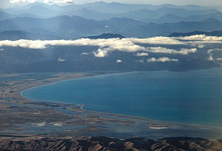
El nombre dual acordado de Te Koko-o-Kupe / Cloudy Bay recuerda las exploraciones maoríes y británicas de Nueva Zelanda.

Algunos nombres oficiales de lugares en Nueva Zelanda son nombres duales , que generalmente incorporan tanto el nombre maorí del lugar como el nombre original dado por los colonizadores o exploradores europeos . Aunque una mezcla de nombres maoríes e ingleses es la forma más común de nombre dual, algunos lugares, como Mahināpua Creek / Tūwharewhare, incluyen elementos maoríes en cada parte del nombre, y Wellington Harbour (Port Nicholson) incorpora dos nombres ingleses. Un nombre, Port Levy (Potiriwi) / Koukourarata , tiene un nombre triple que consiste en el nombre maorí, el nombre europeo y una transliteración maorí de este último.

La práctica de dar nombres duales a ciertos lugares de Nueva Zelanda comenzó en la década de 1920, [1] pero los nombres duales se volvieron mucho más comunes en las décadas de 1990 y 2000, en parte debido a los asentamientos del Tratado de Waitangi . Muchos lugares tienen nombres con una larga herencia en cada cultura. Por ejemplo, un asentamiento vio a Cloudy Bay , que el capitán Cook le dio este nombre en 1770, rebautizada como Te Koko-o-Kupe / Cloudy Bay, [2] con el nombre maorí que recuerda al primer explorador Kupe recogiendo ostras de la bahía. [3]

En casos poco comunes, a un lugar se le pueden dar dos nombres alternativos en lugar de un nombre dual. Algunos ejemplos destacados son la Isla Norte y Te Ika-a-Māui, [4] la Isla Sur y Te Waipounamu, [5] y la ciudad llamada Whanganui o Wanganui. [6] Estos lugares no están incluidos en la lista siguiente.

Asignación y estado

A muchos lugares se les dio oficialmente nombres duales a través del acuerdo del tratado Ngāi Tahu de 1998, incluido Aoraki / Monte Cook.

Los nombres oficiales de lugares en Nueva Zelanda suelen ser determinados por la Junta Geográfica de Nueva Zelanda (Ngā Pou Taunaha o Aotearoa). En los casos en que haya habido objeciones a un nombre propuesto, la decisión final la toma el Ministro de Tierras.

Un gran número de nombres duales no fueron otorgados por el NZGB, sino que fueron negociados como parte de los acuerdos de reclamaciones del Tratado de Waitangi y luego promulgados por el Parlamento. [7] Solo el acuerdo de Ngāi Tahu de 1998 estableció 87 nombres duales, incluido Aoraki / Mount Cook . [8] [9]

Muchos nombres de lugares de Nueva Zelanda no tienen reconocimiento oficial por parte de la NZGB, incluidas la mayoría de las ciudades principales del país y, hasta 2013, las islas del Norte y del Sur . [10] Los nombres no oficiales todavía se registran en el diccionario geográfico, siempre que hayan "aparecido en al menos dos publicaciones o bases de datos autorizadas disponibles públicamente". [11] En la mayoría de los casos, no existe una diferencia funcional entre un nombre oficial y uno no oficial, y la NZGB espera estandarizar los nombres no oficiales como oficiales para 2026. [12]

Ortografía

Originalmente, la junta publicó en el boletín oficial los nombres duales en un formato en el que el nombre menos comúnmente usado estaba entre paréntesis, por ejemplo, Taylors Mistake (Te Onepoto). En la década de 1990, el sistema se cambió para separar los nombres con una barra diagonal, es decir, nombre1/nombre2, por ejemplo, Aoraki/Monte Cook. [13] Ahora, se recomienda colocar un espacio antes y después de la barra diagonal, es decir, nombre1 / nombre2. [7] En 2021, la Junta Geográfica de Nueva Zelanda votó para estandarizar la ortografía de los nombres de lugares duales y está en proceso de actualizar los nombres que usan paréntesis a la barra diagonal más común.

En la actualidad, la junta generalmente coloca el nombre maorí primero, pero a veces se hacen excepciones, por ejemplo, cuando la seguridad marítima es primordial (por ejemplo, Baring Head / Ōrua-pouanui ). [7]

Lista de nombres duales oficiales

Lista de nombres duales no oficiales

See also

References

  1. ^ "Protocol for Mäori Place Names" (PDF). New Zealand Geographic Board Ngā Pou Taunaha o Aotearoa. 14 August 2002. Archived from the original (PDF) on 22 May 2010. Retrieved 12 November 2010.
  2. ^ Initialled version of Te Whakatau/Deed of Settlement between Ngāti Kuia and the Crown for Ratification Purposes Archived 13 March 2016 at the Wayback Machine, p. 23. Office of Treaty Settlements.
  3. ^ Gina Poncini (2004). Exploring the Image of New World Wine Producers: Website Texts for Wineries in Australia and New Zealand. Working Paper 04/2004, Istituto per la comunicazione aziendale, Facoltà di scienze della comunicazione Lugano, Università della Svizzera italiana.
  4. ^ "North Island". New Zealand Gazetteer. Land Information New Zealand. Retrieved 7 August 2021.
  5. ^ "South Island". New Zealand Gazetteer. Land Information New Zealand. Retrieved 7 August 2021.
  6. ^ "Wanganui proposed change to Whanganui: What is the difference between alternative naming and dual naming?". New Zealand Geographic Board Ngā Pou Taunaha o Aotearoa. Archived from the original on 24 May 2010. Retrieved 16 November 2010.
  7. ^ a b c "Frameworks of the New Zealand Geographic Board Ngā Pou Taunaha o Aotearoa: Version 10" (PDF). LINZ. 2018. Retrieved 10 December 2019.
  8. ^ "Mana Recognition". Retrieved 16 November 2010.
  9. ^ a b c d e f g h i j k l m n o p q r s t u v w x y z aa ab ac ad ae af ag ah ai aj ak al am an ao ap aq ar as at au av aw ax ay az ba bb bc bd be bf bg bh bi bj bk bl bm bn bo bp bq br bs bt bu bv bw bx by bz ca cb cc cd ce cf cg ch ci cj ck cl cm cn co cp "Ngāi Tahu Claims Settlement Act 1998 (1998 No 97)".
  10. ^ "Maori names for North and South Islands approved". RNZ. 10 October 2013. Retrieved 15 October 2021.
  11. ^ "Help finding names". Land Information New Zealand. Retrieved 19 March 2011.
  12. ^ "Approving recorded (unofficial) place names as official". linz.govt.nz. Toitū Te Whenua Land Information New Zealand. Retrieved 15 October 2021.
  13. ^ "NZGB Gazetteer". LINZ. Retrieved 11 December 2019.
  14. ^ "NZGB Gazetteer: Aldermen Islands (Ruamaahu) Nature Reserve)". Land Information New Zealand. Retrieved 22 January 2021.
  15. ^ "NZGB Gazetteer: Aotea / Shelly Beach". Land Information New Zealand. Retrieved 22 January 2021.
  16. ^ a b "NZGB Gazetteer: Kawhitu or Stanley Island". Land Information New Zealand. Retrieved 16 October 2021.
  17. ^ "NZGB Gazetteer: Atuanui / Mount Auckland". Land Information New Zealand. Retrieved 22 January 2021.
  18. ^ a b c "Notice of the Final Determinations of the Minister for Land Information on Official Geographic Names". New Zealand Gazette. Retrieved 9 July 2020.
  19. ^ "NZGB Gazetteer: Autere / East End Beach". Land Information New Zealand. Retrieved 22 January 2021.
  20. ^ a b c d e f g h i j k l m n "NZGB Gazetted Notices 26 June 2003" (PDF). Land Information New Zealand.[permanent dead link]
  21. ^ a b c d e f g h i j k l m n o p q r s t u v w x y z aa ab ac ad ae af ag ah ai aj ak al am an ao ap aq ar as at au av aw ax ay az ba bb bc bd be bf bg bh bi bj bk bl bm bn bo bp "New Zealand Gazetteer of Official Geographic Names" (PDF). Land Information New Zealand. 9 September 2010. Retrieved 9 November 2010.[permanent dead link]
  22. ^ "NZGB Gazetteer: Campbell Island / Motu Ihupuku Shelf". Land Information New Zealand. Retrieved 22 January 2021.
  23. ^ a b c d e f g h i j k l m n "New Zealand Gazetteer of Official Geographic Names: Offshore Islands" (PDF). Land Information New Zealand. 23 December 2009. Archived from the original (PDF) on 29 December 2010. Retrieved 17 November 2010.
  24. ^ "NZGB Gazetteer: Cape Kidnappers / Te Kauwae-a-Māui". Land Information New Zealand. Retrieved 22 January 2021.
  25. ^ a b c d e f g h i j k l m n "New Zealand Gazetteer of place names". Land Information New Zealand (LINZ). Retrieved 6 June 2020.
  26. ^ "NZGB Gazetteer: Columbia Bank / Te Nuku-o-Mourea". Land Information New Zealand. Retrieved 22 January 2021.
  27. ^ "NZGB Gazetteer: Dog Island (Motuwhangaikirehe Island)". Land Information New Zealand. Retrieved 21 March 2021.
  28. ^ "NZGB Gazetteer: Double Island (Moturehu) Nature Reserve". Land Information New Zealand. Retrieved 21 March 2021.
  29. ^ "NZGB Gazetteer: Eyre Mountains/Taka Ra Haka Conservation Park". Land Information New Zealand. Retrieved 22 January 2021.
  30. ^ "NZGB Gazetteer: Goat Island/Rakiriri Scenic Reserve". Land Information New Zealand. Retrieved 22 January 2021.
  31. ^ a b c d e f g h i j k l m n o p q r s "NZGB decisions". Land Information New Zealand. August 2014. Archived from the original on 21 November 2015. Retrieved 7 November 2015.
  32. ^ "NZGB Gazetteer: Greville Harbour / Wharariki". Land Information New Zealand. Retrieved 22 January 2021.
  33. ^ "NZGB Gazetteer: Hikurangi / Goulter Hill". Land Information New Zealand. Retrieved 22 January 2021.
  34. ^ "NZGB Gazetteer: Hikurua / de Surville Canyon". Land Information New Zealand. Retrieved 22 January 2021.
  35. ^ "NZGB Gazetteer: Hikurua / de Surville Cliffs". Land Information New Zealand. Retrieved 22 January 2021.
  36. ^ "NZGB Gazetteer: Hinemoatū / Howard River". Land Information New Zealand. Retrieved 22 January 2021.
  37. ^ "NZGB Gazetteer: Horoirangi / Drumduan". Land Information New Zealand. Retrieved 22 January 2021.
  38. ^ a b c d e f g h i "NZGB notices – October 2019". Land Information New Zealand. 17 October 2019. Retrieved 15 December 2019.
  39. ^ a b c d e f g h "Dual place names for Banks Peninsula announced". Land Information New Zealand (LINZ). Retrieved 12 January 2021.
  40. ^ "NZGB Gazetteer: Karaka (Hamilton Island)". Land Information New Zealand. Retrieved 18 April 2021.
  41. ^ "NZGB Gazetteer: Kauri Point Birkenhead / Te Mātā-rae-o-Mana". Land Information New Zealand. Retrieved 22 January 2021.
  42. ^ "NZGB Gazetteer: Kirikirikatata / Mount Cook Range". Land Information New Zealand. Retrieved 22 January 2021.
  43. ^ "NZGB Gazetteer: Kōhatupapā / Ranfurly Bay". Land Information New Zealand. Retrieved 22 January 2021.
  44. ^ "NZGB Gazetteer: Kokota (The Sandspit)". Land Information New Zealand. Retrieved 18 April 2021.
  45. ^ a b c d "Te Arawa Lakes Settlement Act 2006 No 43 – Schedule 4: Place names". 23 May 2008. Retrieved 12 November 2010.
  46. ^ "NZGB Gazetteer: Maniniaro / Angelus Peak". Land Information New Zealand. Retrieved 22 January 2021.
  47. ^ "NZGB Gazetteer: Matapara / Pickersgill Island". Land Information New Zealand. Retrieved 22 January 2021.
  48. ^ "NZGB Gazetteer: Matira / Castle Rock". Land Information New Zealand. Retrieved 22 January 2021.
  49. ^ "NZGB Gazetteer: Maungakura / Red Hill". Land Information New Zealand. Retrieved 22 January 2021.
  50. ^ "NZGB Gazetteer: Maungaroa / Blagdon Hill". Land Information New Zealand. Retrieved 22 January 2021.
  51. ^ "NZGB decisions – September 2014". Land Information New Zealand. Archived from the original on 29 October 2014. Retrieved 25 October 2014.
  52. ^ "Moana-whenua-pōuri / Edwardson Sound". Land Information New Zealand (LINZ). Retrieved 11 January 2021.
  53. ^ "NZGB Gazetteer: Moekawa / South West Island". Land Information New Zealand. Retrieved 22 January 2021.
  54. ^ "NZGB Gazetteer: Moeraki Boulders / Kaihinaki Scenic Reserve". Land Information New Zealand. Retrieved 22 January 2021.
  55. ^ "NZGB Gazetteer: Moeraki River (Blue River)". Land Information New Zealand. Retrieved 22 January 2021.
  56. ^ "New Zealand Gazetteer: Motumānawa / Pollen Island". gazetteer.linz.govt.nz. Retrieved 30 April 2020.
  57. ^ "NZGB Gazetteer: Motunui/Edwards Island". Land Information New Zealand. Retrieved 22 January 2021.
  58. ^ "NZGB Gazetteer: Moutere Hauriri / Bounty Islands Marine Reserve". Land Information New Zealand. Retrieved 22 January 2021.
  59. ^ "NZGB Gazetteer: Moutere Ihupuku / Campbell Island Marine Reserve". Land Information New Zealand. Retrieved 22 January 2021.
  60. ^ "NZGB Gazetteer: Moutere Mahue / Antipodes Island Marine Reserve". Land Information New Zealand. Retrieved 22 January 2021.
  61. ^ "NZGB Gazetteer: Muhuaka / Capstan Rock". Land Information New Zealand. Retrieved 22 January 2021.
  62. ^ "NZGB Gazetteer: Mutukaroa / Hamlin Hill". Land Information New Zealand. Retrieved 22 January 2021.
  63. ^ "NZGB Gazetteer: Ngā Atua Tātā / Kerr Point". Land Information New Zealand. Retrieved 22 January 2021.
  64. ^ "NZGB Gazetteer: Ngataea / Hooper Point". Land Information New Zealand. Retrieved 22 January 2021.
  65. ^ "NZGB Gazetteer: Ōhau / West Island". Land Information New Zealand. Retrieved 22 January 2021.
  66. ^ "NZGB Gazetteer: Ōhinerau / Mount Hobson". Land Information New Zealand. Retrieved 22 January 2021.
  67. ^ "NZGB Gazetteer: Ōhuiarangi / Pigeon Mountain". Land Information New Zealand. Retrieved 22 January 2021.
  68. ^ "NZGB Gazetteer: Ōraumoa / Fighting Bay". Land Information New Zealand. Retrieved 22 January 2021.
  69. ^ "NZGB decisions – September 2014". Land Information New Zealand. Archived from the original on 29 October 2014. Retrieved 25 October 2014.
  70. ^ "NZGB Gazetteer: Ōtaipango / Henderson Bay". Land Information New Zealand. Retrieved 22 January 2021.
  71. ^ "NZGB Gazetteer: Ōtānerua / Hatfields Beach". Land Information New Zealand. Retrieved 22 January 2021.
  72. ^ "NZGB Gazetteer: Paengarēhia / Twilight Beach". Land Information New Zealand. Retrieved 22 January 2021.
  73. ^ "NZGB Gazetteer: Paepae-o-Tū / Bream Tail". Land Information New Zealand. Retrieved 22 January 2021.
  74. ^ a b c Moriori; The Trustees of the Moriori Imi Settlement Trust; The Crown. "Deed of Settlement of Historical Claims" (PDF). Office of Treaty Settlements. pp. 57–58. Retrieved 26 November 2021.
  75. ^ "NZGB Gazetteer: Papawhero / Mount Moturoa". Land Information New Zealand. Retrieved 22 January 2021.
  76. ^ "NZGB Gazetteer: Pariroa / Castle Mount". Land Information New Zealand. Retrieved 22 January 2021.
  77. ^ "NZGB Gazetteer: Pikikirunga / Caanan Downs". Land Information New Zealand. Retrieved 22 January 2021.
  78. ^ "NZGB Gazetteer: Pikimai / Church Hill". Land Information New Zealand. Retrieved 22 January 2021.
  79. ^ "NZGB Gazetteer: Poukirikiri / Travers Saddle". Land Information New Zealand. Retrieved 22 January 2021.
  80. ^ "NZGB Gazetteer: Pūkākā / Marsland Hill". Land Information New Zealand. Retrieved 22 January 2021.
  81. ^ "NZGB Gazetteer: Pukatea / Whites Bay". Land Information New Zealand. Retrieved 22 January 2021.
  82. ^ "NZGB Gazetteer: Pukeahurangi / Jumbo". Land Information New Zealand. Retrieved 22 January 2021.
  83. ^ "NZGB Gazetteer: Pukeone / Mount Campbell". Land Information New Zealand. Retrieved 22 January 2021.
  84. ^ "NZGB Gazetteer: Puketuroto / Hoopers Canyon". Land Information New Zealand. Retrieved 22 January 2021.
  85. ^ "NZGB Gazetteer: Puketuroto / Hoopers Channel". Land Information New Zealand. Retrieved 22 January 2021.
  86. ^ "NZGB Gazetteer: Pūkorokoro / Miranda". Land Information New Zealand. Retrieved 22 January 2021.
  87. ^ "Rangitoto ki te Tonga/D'Urville Island". Archived from the original on 24 May 2010. Retrieved 16 November 2010.
  88. ^ "NZGB Gazetteer: Rangituhi / Colonial Knob". Land Information New Zealand. Retrieved 22 January 2021.
  89. ^ "NZGB decisions – September 2014". Land Information New Zealand. Archived from the original on 29 October 2014. Retrieved 25 October 2014.
  90. ^ "NZGB Gazetteer: Rotokare / Barrett Lagoon". Land Information New Zealand. Retrieved 22 January 2021.
  91. ^ "NZGB Gazetteer: Rotomaninitua / Lake Angelus". Land Information New Zealand. Retrieved 22 January 2021.
  92. ^ "NZGB Gazetteer: Ruakōura / Perpendicular Point". Land Information New Zealand. Retrieved 22 January 2021.
  93. ^ "NZGB Gazetteer: Separation Point / Te Matau". Land Information New Zealand. Retrieved 22 January 2021.
  94. ^ "NZGB Gazetteer: Tāhoro / Union Bay". Land Information New Zealand. Retrieved 22 January 2021.
  95. ^ "NZGB Gazetteer: Taitimu / Caswell Ridge". Land Information New Zealand. Retrieved 22 January 2021.
  96. ^ "NZGB Gazetteer: Takapaukura / Tom Bowling Bay". Land Information New Zealand. Retrieved 22 January 2021.
  97. ^ "NZGB Gazetteer: Takapōtaka / Attempt Hill". Land Information New Zealand. Retrieved 22 January 2021.
  98. ^ "NZGB Gazetteer: Takarunga / Mount Victoria". Land Information New Zealand. Retrieved 22 January 2021.
  99. ^ "Tamatea / Dusky Sound". Land Information New Zealand (LINZ). Retrieved 30 June 2020.
  100. ^ "NZGB Gazetteer: Tapuae-o-Uenuku / Hector Mountains". Land Information New Zealand. Retrieved 22 January 2021.
  101. ^ "Issue No. 114 3213" (PDF). New Zealand Gazette. 25 September 2014. Retrieved 1 July 2020.
  102. ^ "NZGB Gazetteer: Tawhitikurī / Goat Point". Land Information New Zealand. Retrieved 22 January 2021.
  103. ^ "NZGB decisions – Te Awa Kairangi / Hutt River". Archived from the original on 29 December 2010. Retrieved 17 November 2010.
  104. ^ "NZGB Gazetteer: Te Awaroa / Long Sound". Land Information New Zealand. Retrieved 22 January 2021.
  105. ^ "NZGB Gazetteer: Te Hauturu-o-Toi / Little Barrier Island". Land Information New Zealand. Retrieved 22 January 2021.
  106. ^ "NZGB Gazetteer: Te Hāwere-a-Maki / Goat Island". Land Information New Zealand. Retrieved 22 January 2021.
  107. ^ "NZGB Gazetteer: Te Horowai / Speargrass Creek". Land Information New Zealand. Retrieved 22 January 2021.
  108. ^ "NZGB Gazetteer: Te Kā-a-Maki / Jackie Hill". Land Information New Zealand. Retrieved 22 January 2021.
  109. ^ "NZGB Gazetteer: Te Kōhanga / Shipwreck Bay". Land Information New Zealand. Retrieved 22 January 2021.
  110. ^ "NZGB Gazetteer: Te Kohuroa / Mathesons Bay". Land Information New Zealand. Retrieved 22 January 2021.
  111. ^ "Te Korowhakaunu / Cunaris Sound". Land Information New Zealand (LINZ). Retrieved 11 January 2021.
  112. ^ "NZGB Gazetteer linz.govt.nz". gazetteer.linz.govt.nz. Retrieved 1 July 2020.
  113. ^ "Young Nicks Head (Te Kurī) and Te Kuri a Paoa / Young Nick's Head National Historic Reserve". Land Information New Zealand (LINZ). Retrieved 1 July 2020.
  114. ^ "NZGB Gazetteer: Te Mamaku / Ruby Bay". Land Information New Zealand. Retrieved 22 January 2021.
  115. ^ "NZGB decisions – Te Motu Kairangi". Archived from the original on 29 December 2010. Retrieved 17 November 2010.
  116. ^ "NZGB Gazetteer: Te Motu-o-Kura / Bare Island". Land Information New Zealand. Retrieved 22 January 2021.
  117. ^ [1] Deed Of Settlement, Ngati Kuri and the Crown. Retrieved 10 February 2014
  118. ^ "NZGB Gazetteer: Te Pokohiwi / Boulder Bank". Land Information New Zealand. Retrieved 22 January 2021.
  119. ^ "NZGB Gazetteer: Te Poporo / Bulli Point". Land Information New Zealand. Retrieved 22 January 2021.
  120. ^ "NZGB Gazetteer: Te Rau-o-te-Huia / Mount Donald McLean". Land Information New Zealand. Retrieved 22 January 2021.
  121. ^ "NZGB Gazetteer: Te Tara-o-Te-Marama / Mount Freeth". Land Information New Zealand. Retrieved 22 January 2021.
  122. ^ "NZGB Gazetteer: Te Toka-Tapu-a-Kupe / Ninepin Rock". Land Information New Zealand. Retrieved 22 January 2021.
  123. ^ "NZGB Gazetteer: Te Unuhanga-a-Rangitoto / Mercer Bay". Land Information New Zealand. Retrieved 22 January 2021.
  124. ^ "NZGB Gazetteer: Te Wai-o-Pareira / Henderson Creek". Land Information New Zealand. Retrieved 22 January 2021.
  125. ^ "NZGB Gazetteer: Te Waiu o Pukemaire/Braemar Springs". Land Information New Zealand. Retrieved 22 January 2021.
  126. ^ "NZGB Gazetteer: Te Whatu / Berghan Point". Land Information New Zealand. Retrieved 22 January 2021.
  127. ^ "NZGB Gazetteer: Tiriparepa / Scott Point". Land Information New Zealand. Retrieved 22 January 2021.
  128. ^ "NZGB Gazetteer: Tohoraha / Mount Camel". Land Information New Zealand. Retrieved 22 January 2021.
  129. ^ "NZGB Gazetteer: Tokomaru / Mount Robertson". Land Information New Zealand. Retrieved 22 January 2021.
  130. ^ "NZGB notices – February 2019". Land Information New Zealand. 15 November 2019. Retrieved 17 February 2019.
  131. ^ "Waiau Toa / Clarence River". Land Information New Zealand. 18 January 2018. Retrieved 30 January 2018.
  132. ^ "NZGB Gazetteer: Waikutakuta / Robin Hood Bay". Land Information New Zealand. Retrieved 22 January 2021.
  133. ^ "NZGB Gazetteer: Waipaparoa / Howick Beach". Land Information New Zealand. Retrieved 22 January 2021.
  134. ^ "NZGB 2008". Archived from the original on 27 November 2010. Retrieved 16 November 2010.
  135. ^ "NZGB Gazetteer: Watchman Island / Te Kākāwhakaara". Land Information New Zealand. Retrieved 22 January 2021.
  136. ^ "NZGB Gazetteer: Whakaari / White Island Canyon". Land Information New Zealand. Retrieved 22 January 2021.
  137. ^ "NZGB Gazetteer: Whangākea / Pandora". Land Information New Zealand. Retrieved 22 January 2021.
  138. ^ "NZGB notices – June 2019". Land Information New Zealand. 25 June 2019. Retrieved 25 June 2019.
  139. ^ "NZGB Gazetteer: Wharekahika / Hicks Bay". Land Information New Zealand. Retrieved 22 January 2021.
  140. ^ "NZGB Gazetteer: Wharekāpu / Paxton Point". Land Information New Zealand. Retrieved 22 January 2021.
  141. ^ "NZGB Gazetteer: Wharepapa / Arthur Range". Land Information New Zealand. Retrieved 22 January 2021.
  142. ^ a b c d e f g h i j k l m n o p q r s t u v w "NZGB Gazetteer". Land Information New Zealand. Retrieved 16 October 2021.
  143. ^ "NZGB Gazetteer: Ahuru (Eastern Reef)". Land Information New Zealand. Retrieved 21 March 2021.
  144. ^ "NZGB Gazetteer: Boyds Bush (Kaimoko)". Land Information New Zealand. Retrieved 21 March 2021.
  145. ^ "NZGB Gazetteer: Calypso Bay (Otamarau Bay)". Land Information New Zealand. Retrieved 21 March 2021.
  146. ^ "NZGB Gazetteer: Cone Rock (Horoiwi)". Land Information New Zealand. Retrieved 21 March 2021.
  147. ^ "NZGB Gazetteer: Cuvier Island (Repanga Island)". Land Information New Zealand. Retrieved 21 March 2021.
  148. ^ "NZGB Gazetteer: Double Island (Moturehu)". Land Information New Zealand. Retrieved 21 March 2021.
  149. ^ "NZGB Gazetteer: French Bay (Otitori Bay)". Land Information New Zealand. Retrieved 21 March 2021.
  150. ^ "NZGB Gazetteer: French Pass (Anaru)". Land Information New Zealand. Retrieved 21 March 2021.
  151. ^ "NZGB Gazetteer: Goldsborough (Waimea)". Land Information New Zealand. Retrieved 21 March 2021.
  152. ^ "NZGB Gazetteer: Great Barrier Island (Aotea Island)". Land Information New Zealand. Retrieved 21 March 2021.
  153. ^ "NZGB Gazetteer: Great Mercury Island (Ahuahu)". Land Information New Zealand. Retrieved 21 March 2021.
  154. ^ "NZGB Gazetteer: Green Point (Pungawiriwiri)". Land Information New Zealand. Retrieved 21 March 2021.
  155. ^ "NZGB Gazetteer: Greenstone (Pounamu)". Land Information New Zealand. Retrieved 21 March 2021.
  156. ^ "NZGB Gazetteer: Haukawakawa (Madsen)". Land Information New Zealand. Retrieved 11 April 2021.
  157. ^ "NZGB Gazetteer: Horuhoru Rock (Gannet Rock)". Land Information New Zealand. Retrieved 11 April 2021.
  158. ^ "NZGB Gazetteer: Island Bay (Huritini)". Land Information New Zealand. Retrieved 11 April 2021.
  159. ^ "NZGB Gazetteer: Lake Brunner (Moana)". Land Information New Zealand. Retrieved 18 April 2021.
  160. ^ "NZGB Gazetteer: Lake Forsyth (Wairewa)". Land Information New Zealand . Consultado el 18 de abril de 2021 .
  161. ^ "NZGB Gazetteer: Lake Rotokākahi (Green Lake)" (Diccionario geográfico de Nueva Zelanda: lago Rotokākahi [lago verde]). Land Information New Zealand (Información territorial de Nueva Zelanda) . Consultado el 18 de abril de 2021 .
  162. ^ "NZGB Gazetteer: Lake Rotongata (Mirror Lake)". Land Information New Zealand . Consultado el 18 de abril de 2021 .
  163. ^ "Detalle del nombre del lugar: Isla Flat / Isla Motueka". Diccionario geográfico de Nueva Zelanda . Junta Geográfica de Nueva Zelanda . Consultado el 15 de julio de 2023 .
  164. ^ "Pukekawa/Auckland Domain". Ayuntamiento de Auckland . Consultado el 6 de febrero de 2022 .