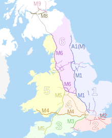
In the Great Britain road numbering scheme, the country is divided into numbered zones, the boundaries of which are usually defined by single-digit roads. The first digit of a road's number should be the number of the zone it occupies. If the road occupies multiple zones, then the furthest-anticlockwise zone is the correct one. The following tables list all British roads which are anomalously numbered. Roads in bold lie completely outside their "correct" zone; all other roads run for some length in their "correct" zones but trespass into zones anticlockwise of this zone. A further table lists duplicated road numbers.
The motorway zone boundaries[1] are different from the A-road boundaries.

While the M25 may appear to contradict these rules as it runs through all the London-bound zones, it in fact does not: it does not quite form a complete circle. It starts in Zone 2, south of the Thames, and proceeds clockwise through zones 3, 4 and 1. The A282, which completes the circle mostly formed by the M25, is anomalously numbered; as it proceeds into the A-road 1-zone (and should therefore begin with a 1).
The M271 is numbered as a spur of the M27, as opposed to the traditional numbering rules; however the M3 to Southampton came after the M271 was built and is not the zone boundary, which appears to be a straight line from M3 J8 to Exeter in some documentation.
