Weetangera (/ˈwiːtæŋɡərə/) is a suburb in the Belconnen district of Canberra, located within the Australian Capital Territory, Australia. The suburb covers an area of approximately 158 hectares (390 acres). Located approximately 10 kilometres (6.2 mi) north-west of the city, Weetangera is bounded by Springvale Drive to the south and west, Coulter Drive to the east and Belconnen Way to the north. The Pinnacle Nature Reserve, a Canberra Nature Park is adjacent to the south of the suburb, across Springvale Drive.
Etymology
Weetangera is named after the original name of the property "Spring Vale", which in turn had been given a name of Aboriginal origin.[3] In 1934, Australian journalist Frederic Slater claimed that the name "Wittanjirra" was an Aboriginal word meaning "to suck, to drink greedily", referring to a spring near the Weetangera Public School.[4] However, Slater does not provide evidence to support this claim.
History
Aboriginal settlement of the Australian Capital Territory dates back over 20,000 years. Grinding grooves located on the Molonglo River to the south of Weetangera provide evidence of Aboriginal use of the region pre-colonisation.[1] Members of the 'Canberra Tribe' continued to camp near Weetangera until the 1860s.[5]
Europeans first settled in the area in the 1820s, with the name Weetangera (also Weetangerra and Weetangara in early documents) applied to the local vicinity from this time. Weetangera was also the name for the historic Weetangera parish, which included the land from Ginninderra Creek to the Molonglo River.
The Weetangera Public School was first built to service the area in 1875, facing onto the Weetangera Road (now Belconnen Way).[6]
Samuel Shumack lived at "Spring Vale" in Weetangera between 1866 and 1915. Shumack and his father had taken up the land for farming when Samuel was eight years old. Samuel Shumack lived on the property with his family until it was claimed as land for the nation's capital in 1915.[7]
The Southwell family were significant to Weetangera, and various members of the family are buried in the Weetangera Cemetery and former Methodist Church now sited to the west of the adjoining suburb, Hawker.
The modern suburb of Weetangera was officially gazetted by the ACT Government in 1968, with a street theme: 'Pioneers of the Australian Capital Territory'.[8] After the gazetting, the first modern settlers moved into the suburb in 1970 and the first students moved into the Weetangera Primary School, located about a kilometre from the old Weetangera Primary School, in 1973.[6][8] Today, the suburb is home to over 2500 people.
People who live in Weetangera are called Weetangerans.[11] At the 2016 census, Weetangera had a population of 2,576 people. The census shows that Weetangera residents have a median age of 43 which is older than the ACT median of 35 and the Australian median of 38. The median weekly household income was A$2,699, significantly more than the ACT median of $2,070 and the Australian median of $1,438.[12]
Weetangera's population is predominantly Australian-born; 75.0 per cent on census night 2016. The second most common birthplace was England at 4.3 per cent. The most common religion is 'no religion', with 41.0% of the population reporting they were not religious.[12]
Suburb amenities
Weetangera has a small shopping centre containing a bakery, beauty salon, dentist, coffee shop, gym, Pakistani restaurant and cleaner.
The suburb is also home to the Weetangera Neighbourhood Oval. The ACT Government announced restoration plans for the oval in June 2012, committing $4 million to three ovals, including the Weetangera oval, over a three-year period. The money is for the installation of irrigation systems, synthetic cricket wickets and practice nets, floodlights and a small pavilion and toilet block.[13]
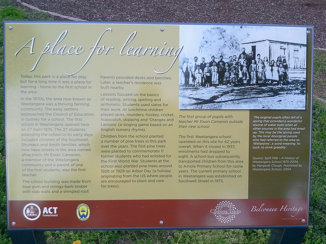
Sign giving history of the original Public School, Weetangera.
The first Public School (pre-High School) was sited on land of the original farming property, and opened on 27 April 1875, with 27 students. The first teacher was Mr Ewan Cameron, a member of the Weetangera community and a parent of a student.
The site is between (beside) the present Belconnen Way (north) and Smith and Kinleyside Streets (south). It now a park, with children's play area, with several lines of pine trees that were planted by students of the original school in about 1919 and 1928/9 (Arbor Day).
People honoured in the streets of Weetangera
The street names in Weetangera are predominantly named for ACT pioneers:
Southwell family graves, late 1800s, Weetangera CemeteryWeetangera is in the centre of this aerial photo.
Abernethy Street – James Abernethy (1830–1920), an overseer and later superintendent of `Yarralumla Station', 1857–63; schoolmaster and clerk at St John the Baptist Church, 1863–80.[15]
Bambridge Street – Edwin Elijah Bambridge (1815–1879), who planted some of the first willow trees along the Molonglo River.[16]
Belconnen Way – "Belconnen" was originally the name of a pioneer's homestead and later of a rural district of the ACT.[17]
Coppin Place – John Coppin (born circa 1840).[18] Coppins Crossing, across the lower Molonglo River, is also named for John Coppin.[19]
Coulter Drive – Robert Charles Coulter (1864–1956); an architect and landscape painter and the co-designer of an award-winning plan in the competition for a Design for the National Capital held in 1911.[20]
Crace Street – Edward Kendall Crace (1844–1892); one of the original settlers in the Gungahlin area becoming one of the largest landholders in the district; purchased the 'Gungahlin' and 'Ginninderra' properties from William Davis in 1877 and also acquired 'Charnwood'.[21]
Darmody Street – John Darmody (1817–1877); employed at 'Duntroon Station' in 1858.[22]
Davis Street – William Davis, senior (1821–1876); arrived in the colony from England on 6 March 1842 on the Palestine with his wife, Jane Elizabeth (née Weston) and several of their children; went to 'Lanyon', home of his daughter and son-in-law; the family moved to Booroomba, where they remained until the early 1860s; sold the property to Charles McKeahnie; Davis then moved to Ginninderra Cottage where he remained until the early 1870s after which he moved to Goulburn; he died in 1876 and his wife died in 1888.[23]
Gibbes Place – Augustus Onslow Manby Gibbes (1828–1897); owned Yarralumla sheep station between 1858 and 1881, purchased from Sir Terence Aubrey Murray and sold to Frederick Campbell.[25]
Gillespie Street – John Gillespie (1809–1889); owned 'Horse Park Station', Ginninderra, 1856–89.[26]
Harcourt Street – George Harcourt (died 1893), a storekeeper in Ginninderra.[27]
Jones Place – Thomas Jones (1812–1887); arrived in the district in 1825; carpenter and farmer; held land at Rocky Gully near Mulligan's Flat, Gungahlin District.[28]
Kilby Crescent – William Kilby (1811–1902); settled at 'Lands End' in Weetangera.[29]
Kinleyside Crescent – George Kinleyside (1820–1886); was a blacksmith and the Postmaster at Ainslie between 1884 and 1886.[30]
Line Place – Thomas Harrington Line (1828–1878); a schoolteacher at Canberra, 1858–60; Superintendent of 'Duntroon Station', 1860; also worked the 'Glebe Farm', 1859.[31]
Mathieson Crescent – William Mathieson (1837–1882); a shepherd on 'Ginninderra Station' from 1860 to 1882.[32]
Mayo Street – Alfred William Mayo (1856–1936); a pioneering farmer of the Majura area.[33]
McKeahnie Street – Charles McKeahnie (1809–1903); owner, at various times, of properties in Boboyan, Gudgenby, Orroral and Booroomba areas. He and his wife Elizabeth came to Australia from Scotland in 1838.[34][35] They were the grandparents of Charlie McKeahnie, who some historians believe to be the inspiration for the poem 'The Man from Snowy River' by Banjo Paterson.[36]
McLachlan Crescent – Allan McLachlan (1835–1878); the manager of "Duntroon Station" in 1876.[37]
Morton Street – Andrew Morton (1812–1881); a pioneer medical practitioner and coroner in the Queanbeyan district.[38]
Mowle Place – Stewart Majoribanks Mowle (1822–1908); employed at 'Yarralumla Station' between 1838 and 1845.[39]
O'Rourke Street – Terence O'Rourke (1831–1896); employed on 'Duntroon Station' during the 1850s.[40]
Packer Street – William James Packer (1793–1881); the first settler at Gundaroo in 1824, who owned 'Esthermead Estate'.[41]
Plummer Street – Levi Plummer (1822–1876); settled at Weetangera in the early 1870s; died after falling from a horse in 1876; his wife, Frances (née Guthridge), died in 1891.[42]
Shumack Street – Richard Shumack (1817–1887); father of Samuel Shumack and employed at 'Duntroon Station' between 1856 and 1858 and later with his son, Samuel, established 'Springvale Station' at Weetangera.[43]
Smith Street – named for ACT pioneer clergymen.[44]
Southwell Street – Thomas Southwell (1813–1881); the owner of "Parkwood" station from 1854.[45] Southwell was responsible for the introduction of Methodism into the Weetangera area.[46]
Springvale Drive – named for a homestead in the Weetangera area established by Samuel Shumack and his father Richard Shumack in 1866.[47]
Vest Place – Richard Vest (1855–1922); an overseer at 'Yarralumla Station', 1897–1911.[48]
Webb Place – George Solomon Webb (1783–1868); a pioneer settler in the Tidbinbilla area, 1833; married to Sarah Rolfe, the step-daughter of Timothy Beard. Their eldest daughter Eliza Webb married John McDonald, the son of the original settlers at Uriarra. Mount Eliza in Tidbinbilla is believed to be named in her honour.[49]
Weetangera Place – the name has been associated with the area since the days of the early settlers.[50]
Geology
Silurian age green grey rhyodacite of the Walker Volcanics underlie the whole suburb.[51]
References
^Australian Bureau of Statistics (28 June 2022). "Weetangera (suburb and locality)". Australian Census 2021 QuickStats. Retrieved 28 June 2022.
^ACT Territory and Municipal Services (9 September 2009). "Suburbs & their names" (PDF). ACT Territory and Municipal Services. Archived from the original (PDF) on 26 January 2013. Retrieved 28 March 2013.
^"Place Names: Australian Capital Territory". Australia For Everyone. Archived from the original on 13 March 2013. Retrieved 22 March 2013.
^Slater, Frederic (1934). "Aboriginal Names in the Federal Capital". Mankind. 1 (10): 236–239. doi:10.1111/j.1835-9310.1934.tb00048.x. ISSN 1835-9310.
^Schumack, Samuel (11 June 1927). "Canberra Blacks". The Sydney Morning Herald. Retrieved 22 August 2020.
^ a b"Weetangera Primary School: Our History". 16 May 2011. Archived from the original on 1 March 2012. Retrieved 28 March 2013.
^"OBITUARY. Mr. Samuel Shumack". The Canberra Times. 10 April 1940. Retrieved 20 March 2013.
^ a bBrian Rhynehart (27 February 2008). "Belconnen history timeline". Belconnen Community. Archived from the original on 21 March 2012. Retrieved 22 March 2013.
^"Profile of the electoral division of Canberra (ACT)". Current federal electoral divisions. Australian Electoral Commission. 17 August 2018. Retrieved 21 June 2019.
^"Electorates 2012 election". Electorates. ACT Electoral Commission. 5 July 2012. Retrieved 17 December 2013.
^Pettit, Philip (3 July 1988). "Fogs clear over Weetangera". The Canberra Times. My Suburb, Cycling, Business. Retrieved 13 April 2013.
^ a bAustralian Bureau of Statistics (27 June 2017). "Weetangera (State Suburb)". 2016 Census QuickStats. Retrieved 29 June 2017.
^"ACT Labor delivers $13.5 million in upgrades to local sporting facilities". ACT Government. 2 June 2012. Archived from the original on 28 June 2012. Retrieved 23 March 2013.
^Weetangera Primary School
^"Abernethy Street". ACT Planning and Land Authority. 13 June 2012. Retrieved 22 March 2013.
^"Bambridge Street". ACT Planning and Land Authority. 13 June 2012. Archived from the original on 10 April 2012. Retrieved 22 March 2013.
^"Belconnen Way". ACT Planning and Land Authority. 13 June 2012. Archived from the original on 7 April 2012. Retrieved 23 March 2013.
^"Coppin Place". ACT Planning and Land Authority. 13 June 2012. Archived from the original on 10 April 2012. Retrieved 22 March 2013.
^Colin McAlister (November 2007). "Twelve Historic Sites in the Glenburn and Burbong" (PDF). National Parks Association of the ACT Inc. Archived from the original (PDF) on 21 March 2012. Retrieved 22 March 2013.
^"Coulter Drive". ACT Planning and Land Authority. 13 June 2012. Archived from the original on 7 April 2012. Retrieved 22 March 2013.
^"Crace Street". ACT Planning and Land Authority. 13 June 2012. Archived from the original on 10 April 2012. Retrieved 22 March 2013.
^"Darmody Street". ACT Planning and Land Authority. 13 June 2012. Archived from the original on 10 April 2012. Retrieved 22 March 2013.
^"Davis Street". ACT Planning and Land Authority. 13 June 2012. Archived from the original on 10 April 2012. Retrieved 22 March 2013.
^"De Salis Street". ACT Planning and Land Authority. 13 June 2012. Archived from the original on 10 April 2012. Retrieved 22 March 2013.
^"Gibbes Place". ACT Planning and Land Authority. 13 June 2012. Archived from the original on 10 April 2012. Retrieved 22 March 2013.
^"Gillespie Street". ACT Planning and Land Authority. 13 June 2012. Archived from the original on 10 April 2012. Retrieved 22 March 2013.
^"Harcourt Street". ACT Planning and Land Authority. 13 June 2012. Archived from the original on 10 April 2012. Retrieved 22 March 2013.
^"Jones Place". ACT Planning and Land Authority. 13 June 2012. Archived from the original on 10 April 2012. Retrieved 22 March 2013.
^"Kilby Crescent". ACT Planning and Land Authority. 13 June 2012. Archived from the original on 10 April 2012. Retrieved 22 March 2013.
^"Kinleyside Crescent". ACT Planning and Land Authority. 13 June 2012. Archived from the original on 10 April 2012. Retrieved 22 March 2013.
^"Line Place". ACT Planning and Land Authority. 13 June 2012. Archived from the original on 10 April 2012. Retrieved 22 March 2013.
^"Mathieson Crescent". ACT Planning and Land Authority. 13 June 2012. Archived from the original on 10 April 2012. Retrieved 22 March 2013.
^"Mayo Street". ACT Planning and Land Authority. 20 March 2012. Archived from the original on 10 April 2012. Retrieved 22 March 2013.
^"McKeahnie Street". ACT Planning and Land Authority. 13 June 2012. Archived from the original on 10 April 2012. Retrieved 23 March 2013.
^"McKeahnie Major". Geocaching. Retrieved 26 March 2013.
^Charles Duncan McKeahnie, The Monaro Pioneers, archived from the original on 16 July 2014
^"McLachlan Street". ACT Planning and Land Authority. 13 June 2012. Archived from the original on 10 April 2012. Retrieved 23 March 2013.
^"Morton Street". ACT Planning and Land Authority. 13 June 2012. Archived from the original on 10 April 2012. Retrieved 22 March 2013.
^"Mowle Place". ACT Planning and Land Authority. 13 June 2012. Archived from the original on 10 April 2012. Retrieved 23 March 2013.
^"O'Rourke Street". ACT Planning and Land Authority. 13 June 2012. Archived from the original on 10 April 2012. Retrieved 23 March 2013.
^"Packer Street". ACT Planning and Land Authority. 13 June 2012. Archived from the original on 10 April 2012. Retrieved 23 March 2013.
^"Plummer Street". ACT Planning and Land Authority. 13 June 2012. Archived from the original on 10 April 2012. Retrieved 23 March 2013.
^"Shumack Street". ACT Planning and Land Authority. 13 June 2012. Archived from the original on 10 April 2012. Retrieved 22 March 2013.
^"Smith Street". ACT Planning and Land Authority. 13 June 2012. Archived from the original on 10 April 2012. Retrieved 23 March 2013.
^"Southwell Street". ACT Planning and Land Authority. 13 June 2012. Archived from the original on 10 April 2012. Retrieved 22 March 2013.
^"Weetangera Cemetery" (PDF). Retrieved 23 March 2013.
^"Springvale Drive". ACT Planning and Land Authority. 13 June 2012. Archived from the original on 10 April 2012. Retrieved 23 March 2013.
^"Vest Place". ACT Planning and Land Authority. 13 June 2012. Archived from the original on 10 April 2012. Retrieved 23 March 2013.
^"Webb Place". ACT Planning and Land Authority. 13 June 2012. Archived from the original on 10 April 2012. Retrieved 22 March 2013.
^"Weetangera Place". ACT Planning and Land Authority. 13 June 2012. Archived from the original on 10 April 2012. Retrieved 23 March 2013.
^Henderson G A M and Matveev G, Geology of Canberra, Queanbeyan and Environs 1:50000 1980.