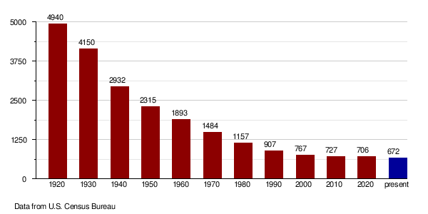
Slope County is a county in the U.S. state of North Dakota. As of the 2020 census, the population was 706,[1] making it the least populous county in North Dakota and the 18th-least populous county in the United States. The county seat is Amidon.[2]
The vote to create Slope County, by partitioning the lower portion of Billings, was held on November 3, 1914. This was the final (as of 2019) alteration to that once-large Dakota county, as Bowman had been partitioned off in 1883, and Golden Valley was split off in 1910. The unorganized Slope County was not attached to another county for administrative or judicial purposes during the interregnum; on January 14, 1915, the county organization was effected.[3][4][5] The name refers to the Missouri Slope, a geographical feature that is also a popular designation for western North Dakota, particularly the area west of the Missouri River.
.JPG/1280px-White_butte_(1).JPG)
Slope County lies on the lower west side of North Dakota. Its west boundary line abuts the east boundary line of the state of Montana. The Little Missouri River enters the county's south boundary line from Bowman County near the Montana border and flows north until it loops very briefly into Golden Valley County. Then it flows east to near the midpoint of the north boundary of Slope County and then turns north into Billings County. Cedar Creek drains the southeastern portion of the county, flowing south into Bowman county.
Slope County terrain consists of semi-arid rough hills and gullies interspersed with lower hills, part of which is dedicated to agriculture.[6] The terrain slopes to the east and south; its highest area (except for isolated prominences, such as White Butte) is its northwestern corner, at 3,104 ft (946 m) ASL.[7] The county has a total area of 1,219 square miles (3,160 km2), of which 1,215 square miles (3,150 km2) is land and 4.2 square miles (11 km2) (0.3%) is water.[8]
White Butte, the highest natural point in North Dakota at an elevation of 3,506 ft (1,069 m), is in southeast Slope County.
As of the census of 2020, there were 706 people.
As of the census of 2010, there were 727 people, 326 households, and 224 families in the county. The population density was 0.60 people per square mile (0.23 people/km2). There were 436 housing units at an average density of 0.36 units per square mile (0.14/km2). The racial makeup of the county was 97.5% white, 2.2% American Indian, 0.0% from other races, and 0.3% from two or more races. Those of Hispanic or Latino origin made up 1.7% of the population. In terms of ancestry, 53.9% were of German, 30.7% Norwegian, 9.9% English, 7.4% Swedish, 5.5% Polish and 2.8% American ancestry.
Of the 326 households, 22.4% had children under the age of 18 living with them, 60.7% were married couples living together, 4.9% had a female householder with no husband present, 31.3% were non-families, and 29.4% of all households were made up of individuals. The average household size was 2.23 and the average family size was 2.74. The median age was 49.2 years.
The median income for a household in the county was $43,625 and the median income for a family was $55,833. Males had a median income of $36,458 versus $31,172 for females. The per capita income for the county was $24,824. About 6.8% of families and 10.5% of the population were below the poverty line, including 9.3% of those under age 18 and 11.7% of those age 65 or over.
Slope County has the highest decline from its peak population of all US counties.
Slope County voters have traditionally voted Republican. In no national election since 1964 has the county selected the Democratic Party candidate (as of 2020). In 2020 Donald Trump received 89% of the vote in Slope County.
School districts include:[15]
Former school districts:
The Amidon and Cottage schools were the final two schools remaining in the county.[19]
This dissolution would not take effect until July 1, 2020 so there is time to review this information.
RR 1 Box 21 Bowman ND 58623-9203 Sheets 14
46°27′N 103°28′W / 46.45°N 103.46°W / 46.45; -103.46


